Alexander Zipf

10 papers on arXiv

Academic Profile

Name: A. Zipf
Total Papers: 33

Statistics

arXiv Papers 10
Total Publications 33

Papers on arXiv

Thumbnail for Distortions in Judged Spatial Relations in Large Language Models

Distortions in Judged Spatial Relations in Large Language Models

We present a benchmark for assessing the capability of Large Language Models (LLMs) to discern intercardinal directions between geographic locations and apply it to three prominent LLMs: GPT-3.5, GP...

Thumbnail for Cross-City Matters: A Multimodal Remote Sensing Benchmark Dataset for
  Cross-City Semantic Segmentation using High-Resolution Domain Adaptation
  Networks

Cross-City Matters: A Multimodal Remote Sensing Benchmark Dataset for Cross-City Semantic Segmentation using High-Resolution Domain Adaptation Networks

Artificial intelligence (AI) approaches nowadays have gained remarkable success in single-modality-dominated remote sensing (RS) applications, especially with an emphasis on individual urban environ...

Thumbnail for Semi-supervised Learning from Street-View Images and OpenStreetMap for
  Automatic Building Height Estimation

Semi-supervised Learning from Street-View Images and OpenStreetMap for Automatic Building Height Estimation

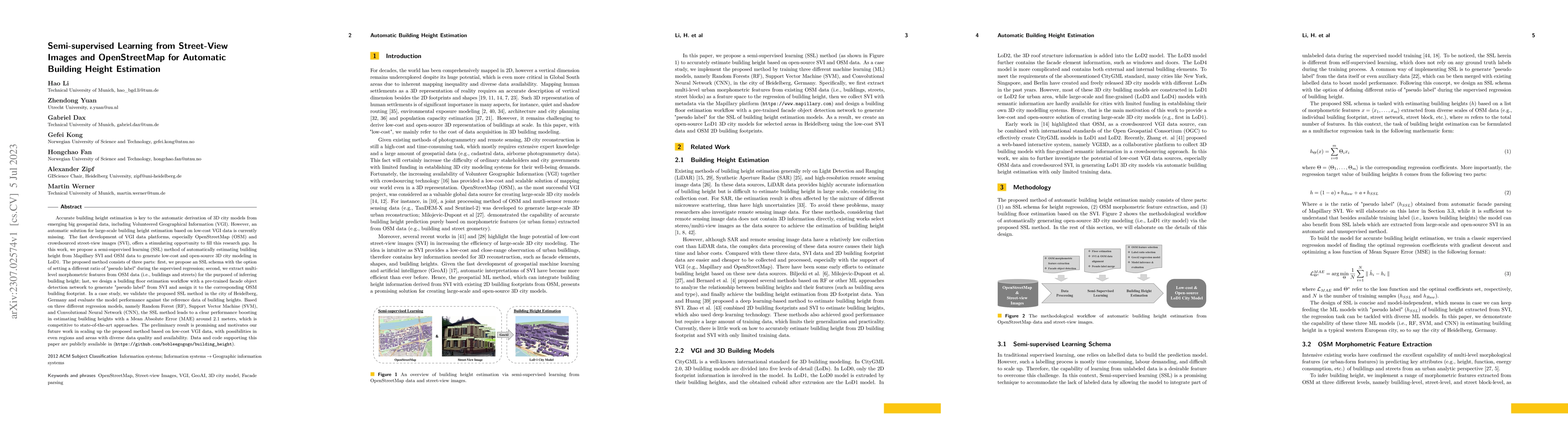
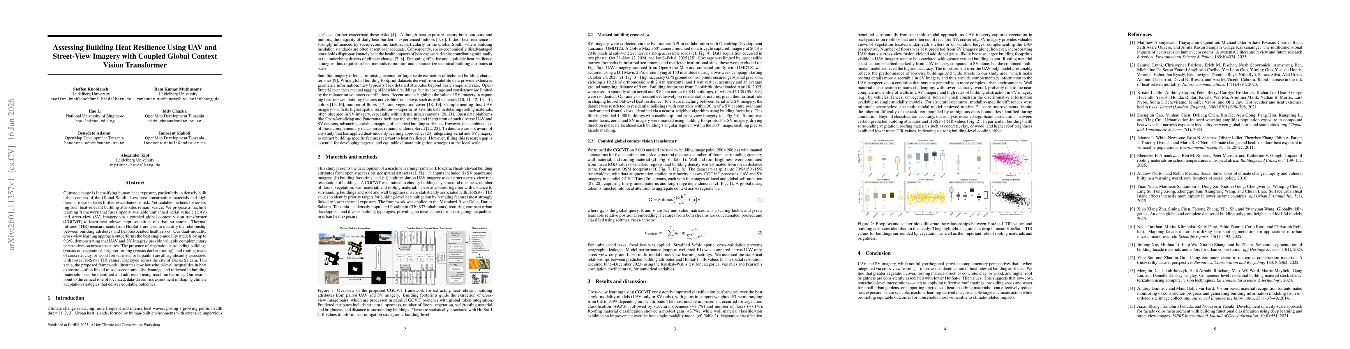
Accurate building height estimation is key to the automatic derivation of 3D city models from emerging big geospatial data, including Volunteered Geographical Information (VGI). However, an automati...

Thumbnail for Deep Learning Enhanced Road Traffic Analysis: Scalable Vehicle Detection
  and Velocity Estimation Using PlanetScope Imagery

Deep Learning Enhanced Road Traffic Analysis: Scalable Vehicle Detection and Velocity Estimation Using PlanetScope Imagery

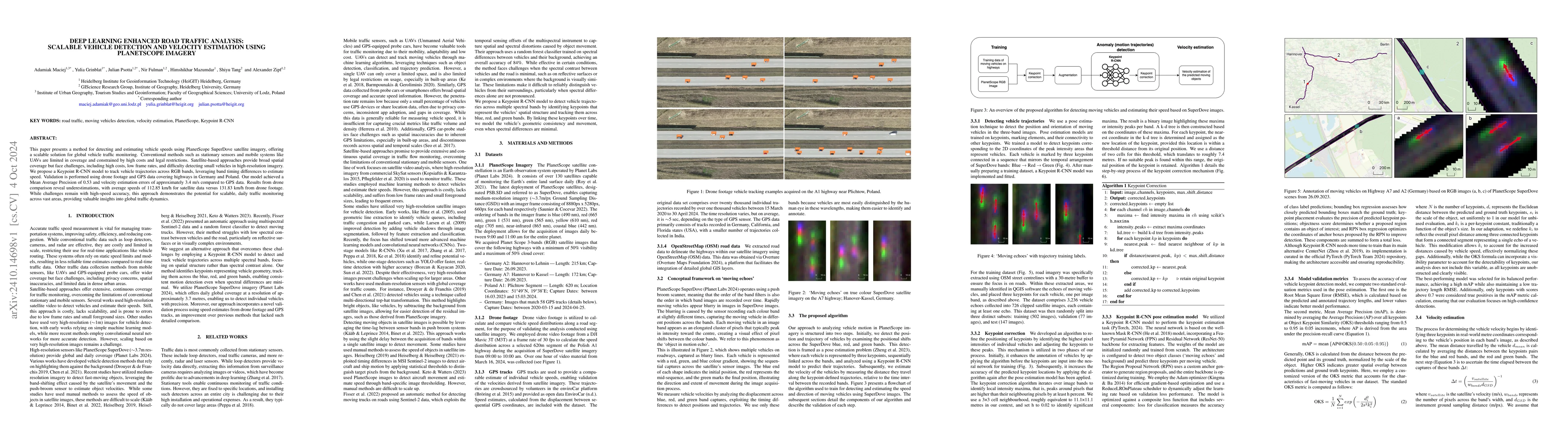
This paper presents a method for detecting and estimating vehicle speeds using PlanetScope SuperDove satellite imagery, offering a scalable solution for global vehicle traffic monitoring. Conventional...

Thumbnail for Paved or unpaved? A Deep Learning derived Road Surface Global Dataset
  from Mapillary Street-View Imagery

Paved or unpaved? A Deep Learning derived Road Surface Global Dataset from Mapillary Street-View Imagery

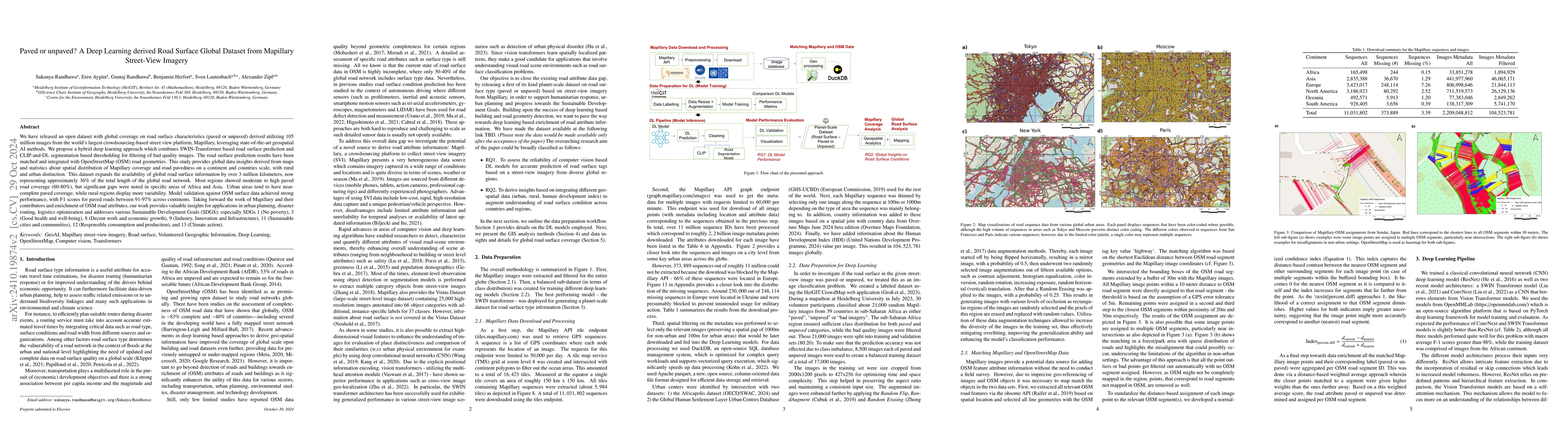
We have released an open dataset with global coverage on road surface characteristics (paved or unpaved) derived utilising 105 million images from the world's largest crowdsourcing-based street view p...

Thumbnail for The changing surface of the world's roads

The changing surface of the world's roads

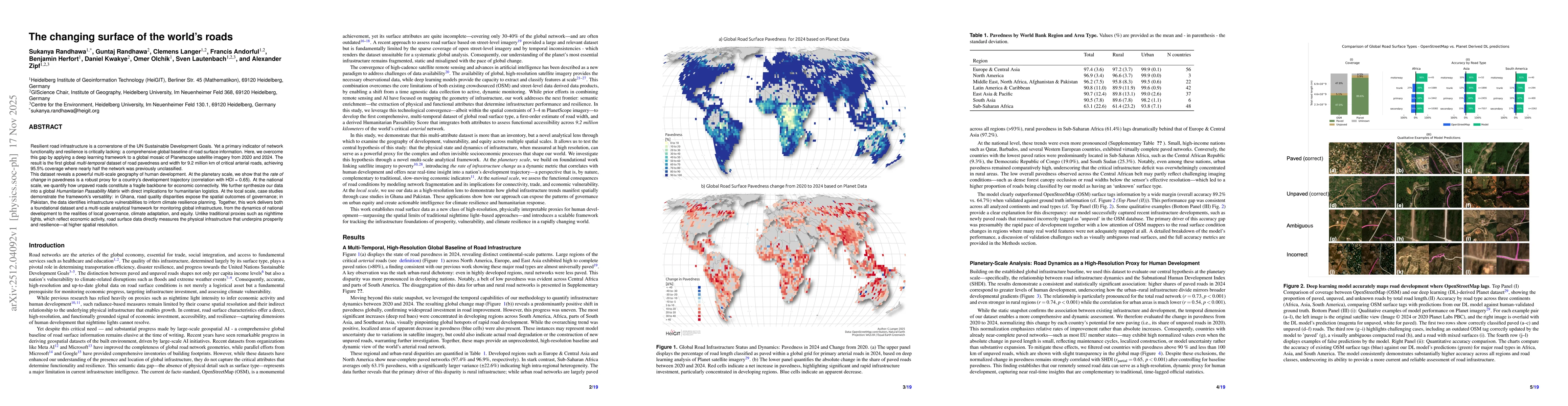
Resilient road infrastructure is a cornerstone of the UN Sustainable Development Goals. Yet a primary indicator of network functionality and resilience is critically lacking: a comprehensive global ba...

Thumbnail for Assessing Building Heat Resilience Using UAV and Street-View Imagery with Coupled Global Context Vision Transformer

Assessing Building Heat Resilience Using UAV and Street-View Imagery with Coupled Global Context Vision Transformer

Climate change is intensifying human heat exposure, particularly in densely built urban centers of the Global South. Low-cost construction materials and high thermal-mass surfaces further exacerbate t...

Thumbnail for Automated Road Crack Localization to Guide Highway Maintenance

Automated Road Crack Localization to Guide Highway Maintenance

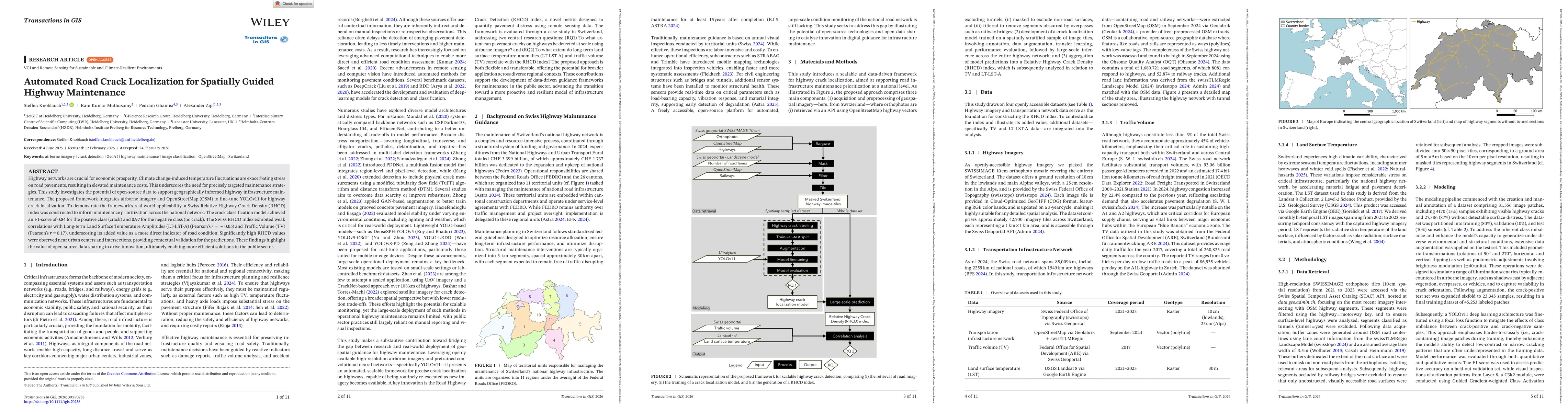
Highway networks are crucial for economic prosperity. Climate change-induced temperature fluctuations are exacerbating stress on road pavements, resulting in elevated maintenance costs. This underscor...

Thumbnail for AI-based Waste Mapping for Addressing Climate-Exacerbated Flood Risk

AI-based Waste Mapping for Addressing Climate-Exacerbated Flood Risk

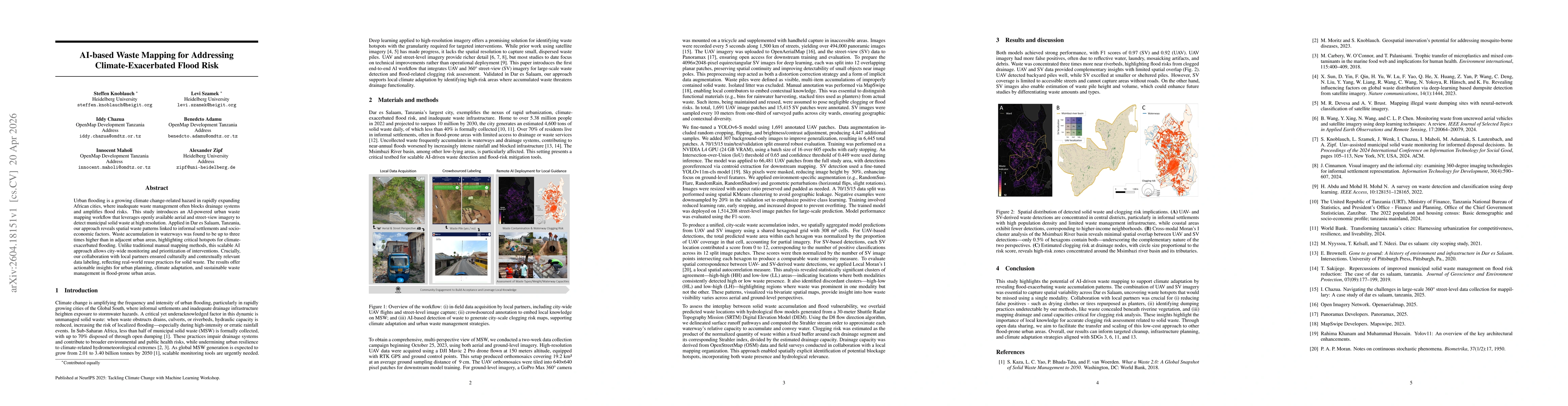
Urban flooding is a growing climate change-related hazard in rapidly expanding African cities, where inadequate waste management often blocks drainage systems and amplifies flood risks. This study int...

Thumbnail for Open-access model for detecting openly dumped dispersed municipal solid waste from crowdsourced UAV imagery in Sub-Saharan Africa

Open-access model for detecting openly dumped dispersed municipal solid waste from crowdsourced UAV imagery in Sub-Saharan Africa

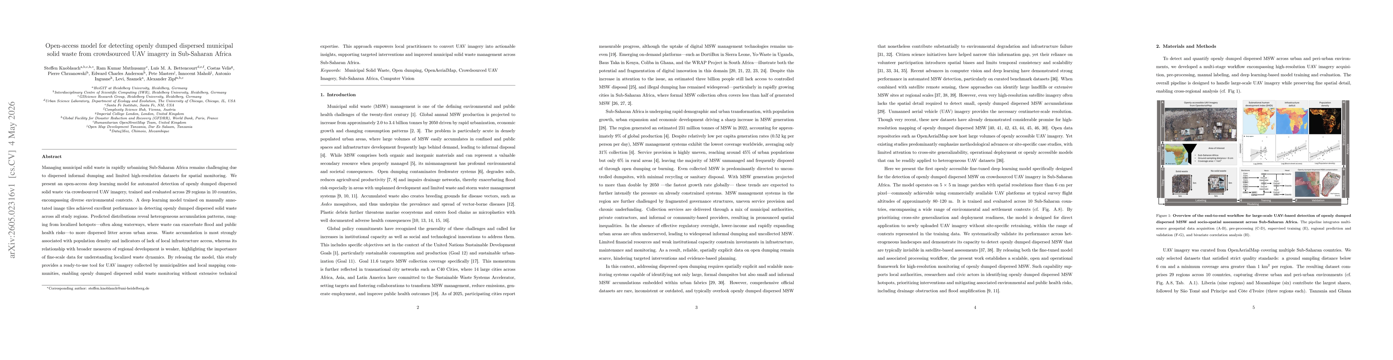
Managing municipal solid waste in rapidly urbanizing Sub-Saharan Africa remains challenging due to dispersed informal dumping and limited high-resolution datasets for spatial monitoring. We present an...

This website uses cookies to ensure you get the best experience. Learn more