Academic Profile
Statistics
Similar Authors
Papers on arXiv
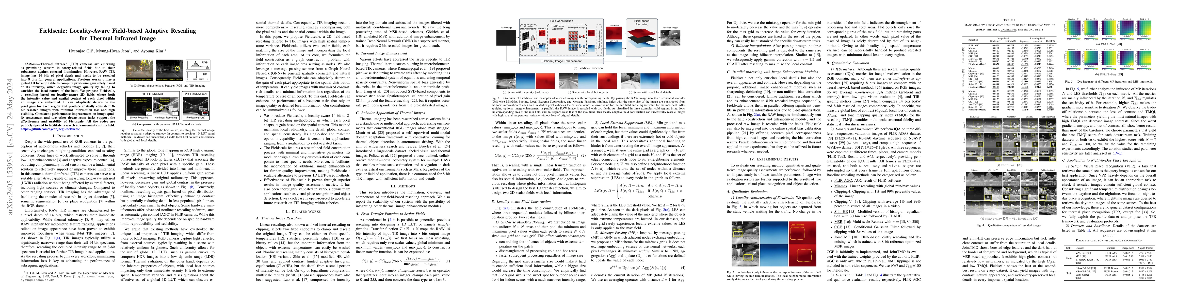
Thermal infrared (TIR) cameras are emerging as promising sensors in safety-related fields due to their robustness against external illumination. However, RAW TIR image has 14 bits of pixel depth and...
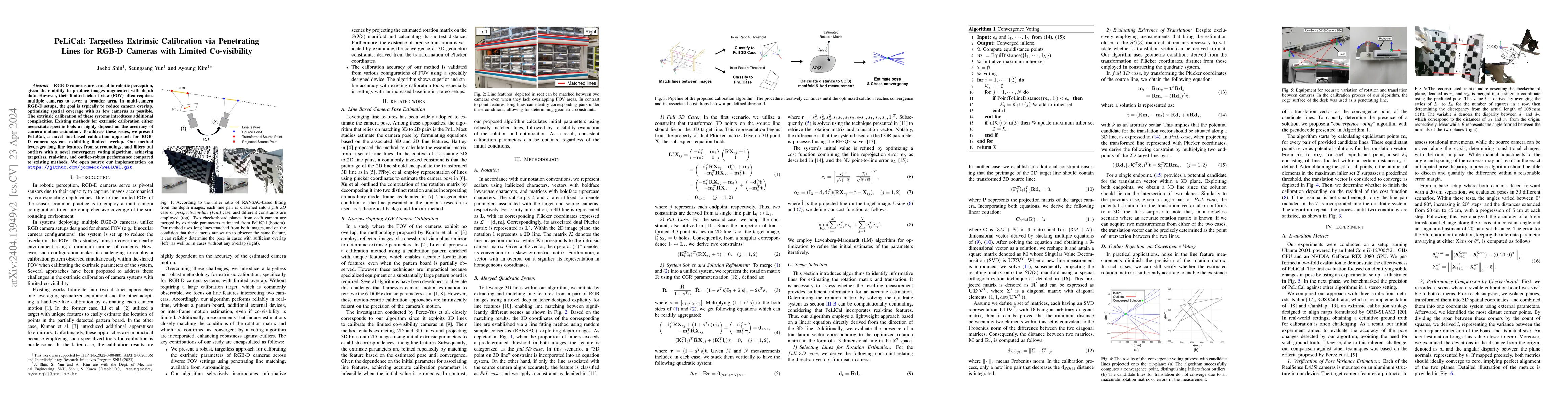
RGB-D cameras are crucial in robotic perception, given their ability to produce images augmented with depth data. However, their limited FOV often requires multiple cameras to cover a broader area. ...
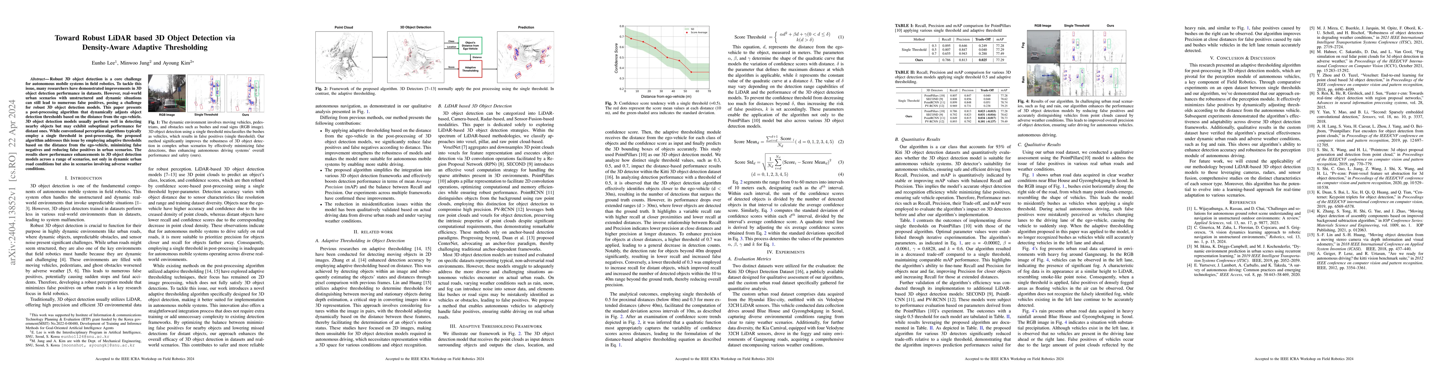
Robust 3D object detection is a core challenge for autonomous mobile systems in field robotics. To tackle this issue, many researchers have demonstrated improvements in 3D object detection performan...
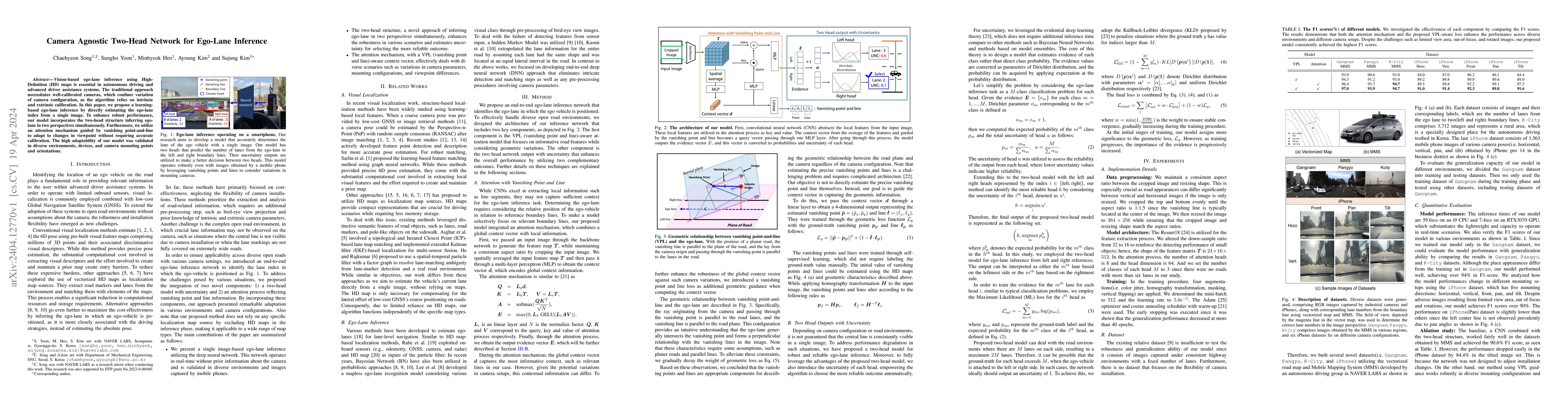
Vision-based ego-lane inference using High-Definition (HD) maps is essential in autonomous driving and advanced driver assistance systems. The traditional approach necessitates well-calibrated camer...
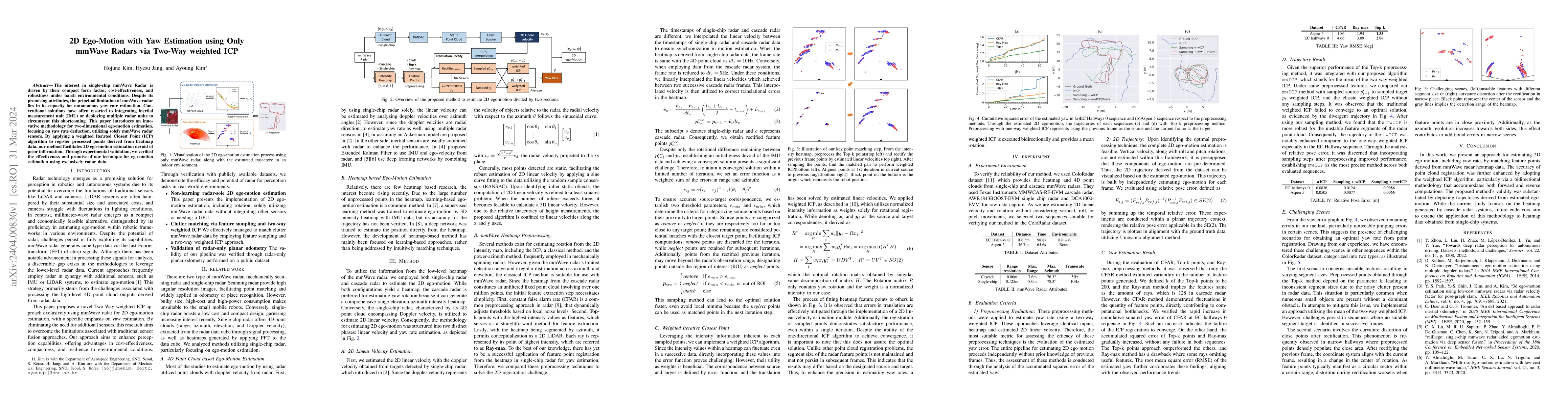
The interest in single-chip mmWave Radar is driven by their compact form factor, cost-effectiveness, and robustness under harsh environmental conditions. Despite its promising attributes, the princi...
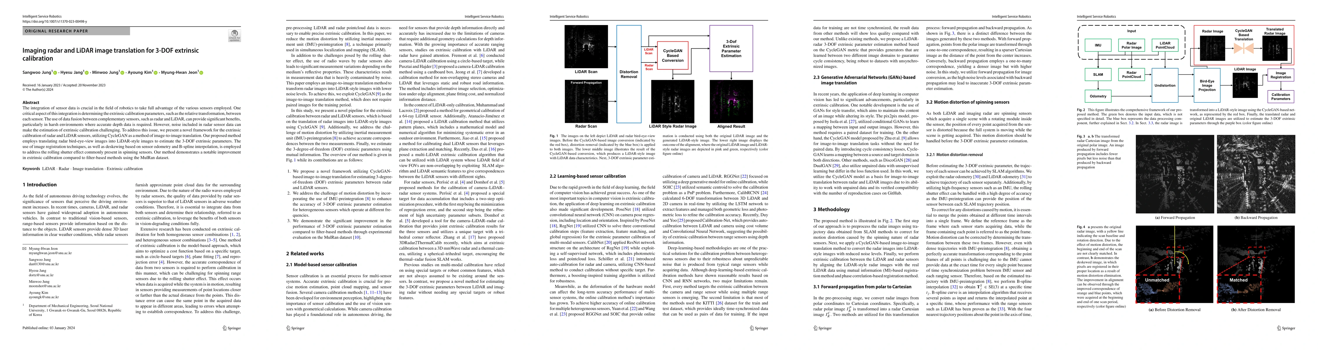
The integration of sensor data is crucial in the field of robotics to take full advantage of the various sensors employed. One critical aspect of this integration is determining the extrinsic calibr...
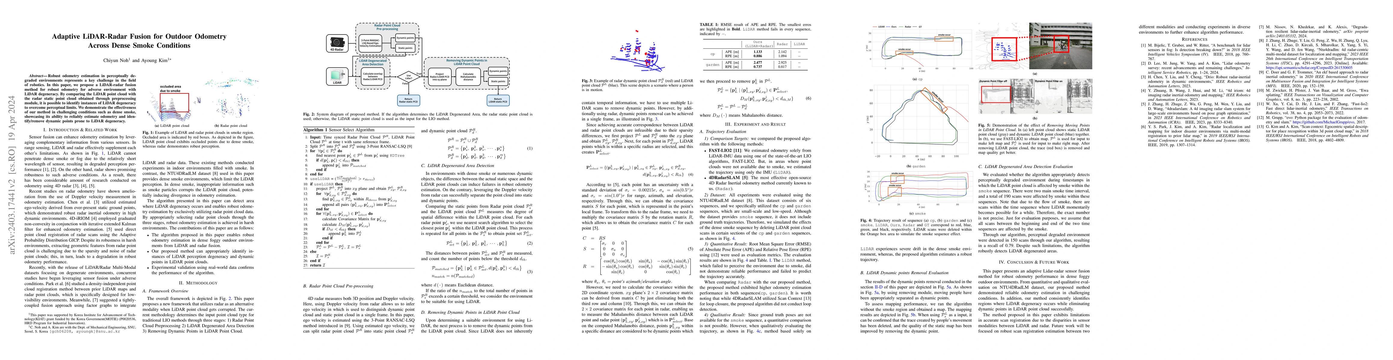
Robust odometry estimation in perceptually degraded environments represents a key challenge in the field of robotics. In this paper, we propose a LiDAR-radar fusion method for robust odometry for ad...
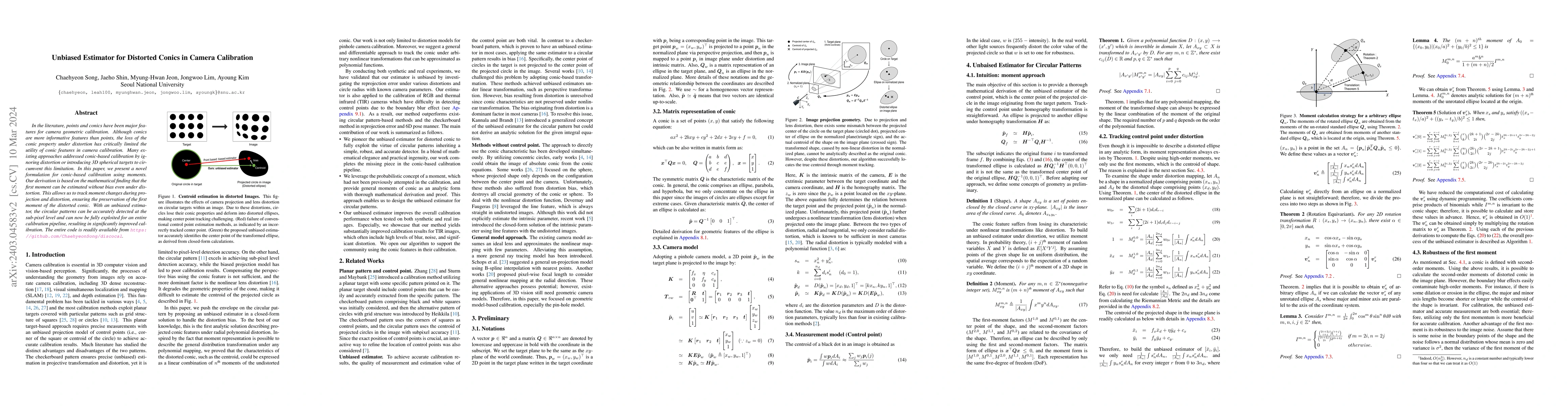
In the literature, points and conics have been major features for camera geometric calibration. Although conics are more informative features than points, the loss of the conic property under distor...
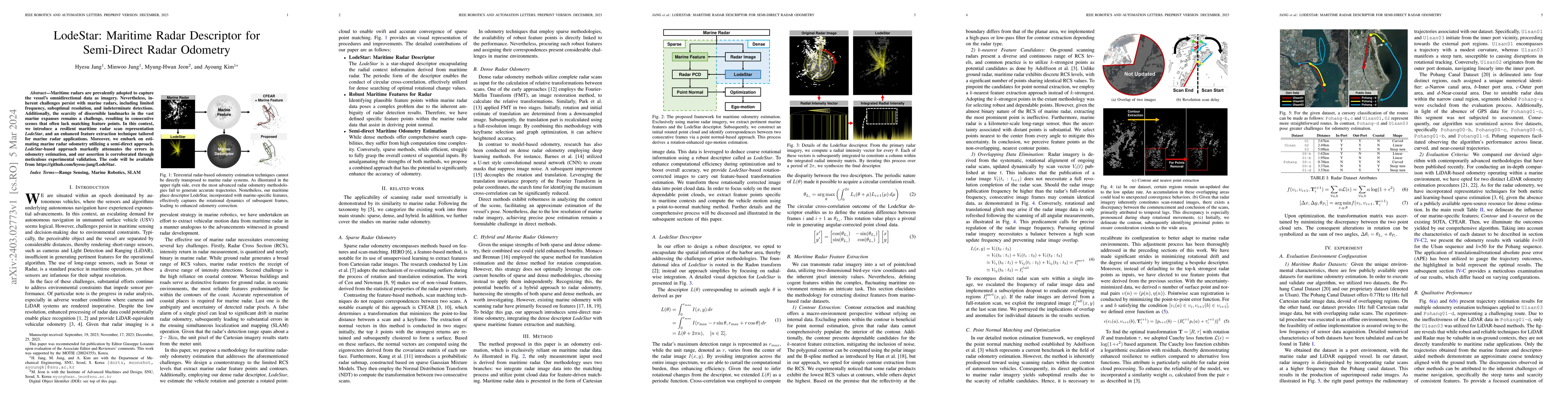
Maritime radars are prevalently adopted to capture the vessel's omnidirectional data as imagery. Nevertheless, inherent challenges persist with marine radars, including limited frequency, suboptimal...
Odometry is crucial for robot navigation, particularly in situations where global positioning methods like global positioning system (GPS) are unavailable. The main goal of odometry is to predict th...
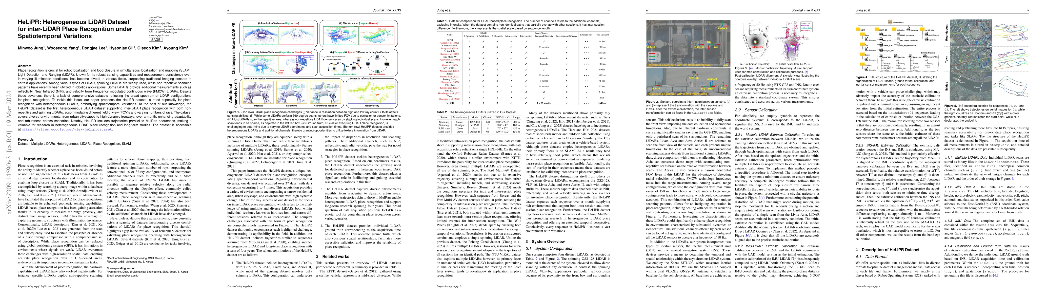
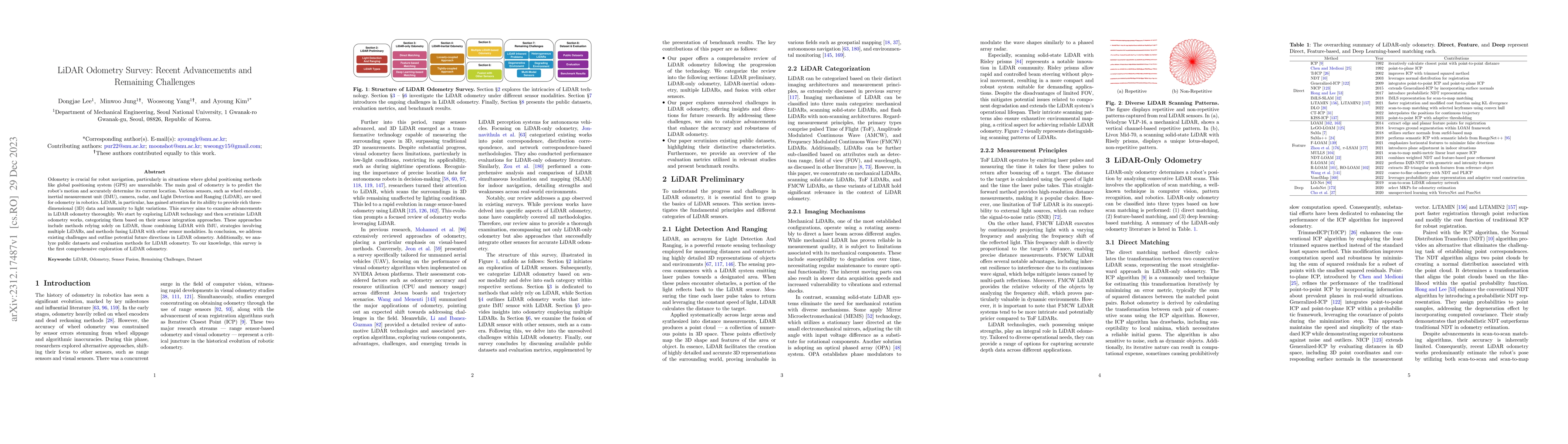
Place recognition is crucial for robot localization and loop closure in simultaneous localization and mapping (SLAM). Light Detection and Ranging (LiDAR), known for its robust sensing capabilities a...
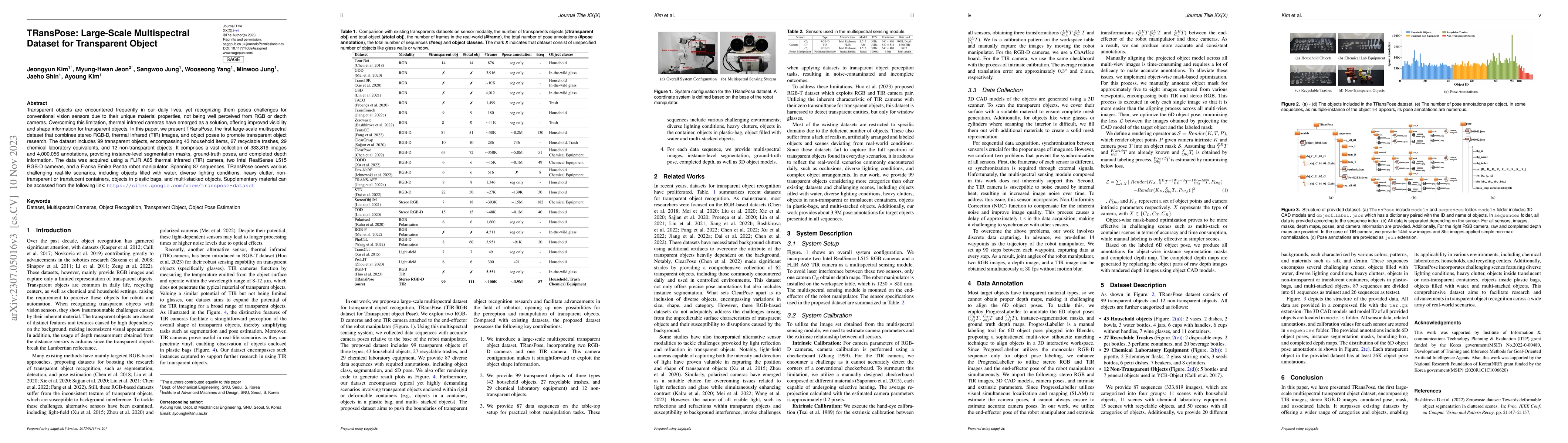
Transparent objects are encountered frequently in our daily lives, yet recognizing them poses challenges for conventional vision sensors due to their unique material properties, not being well perce...
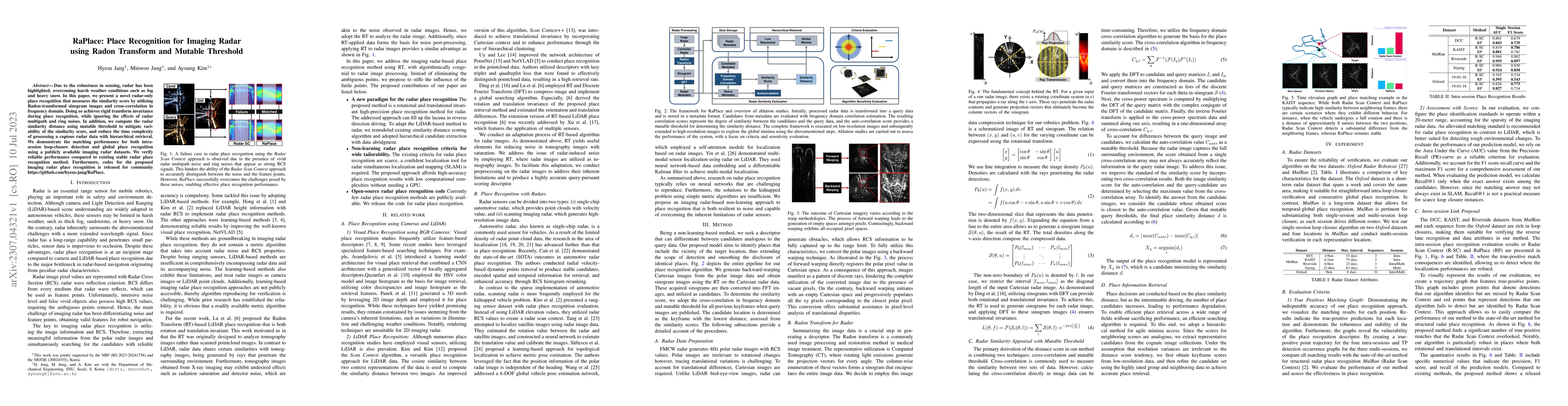
Due to the robustness in sensing, radar has been highlighted, overcoming harsh weather conditions such as fog and heavy snow. In this paper, we present a novel radar-only place recognition that meas...
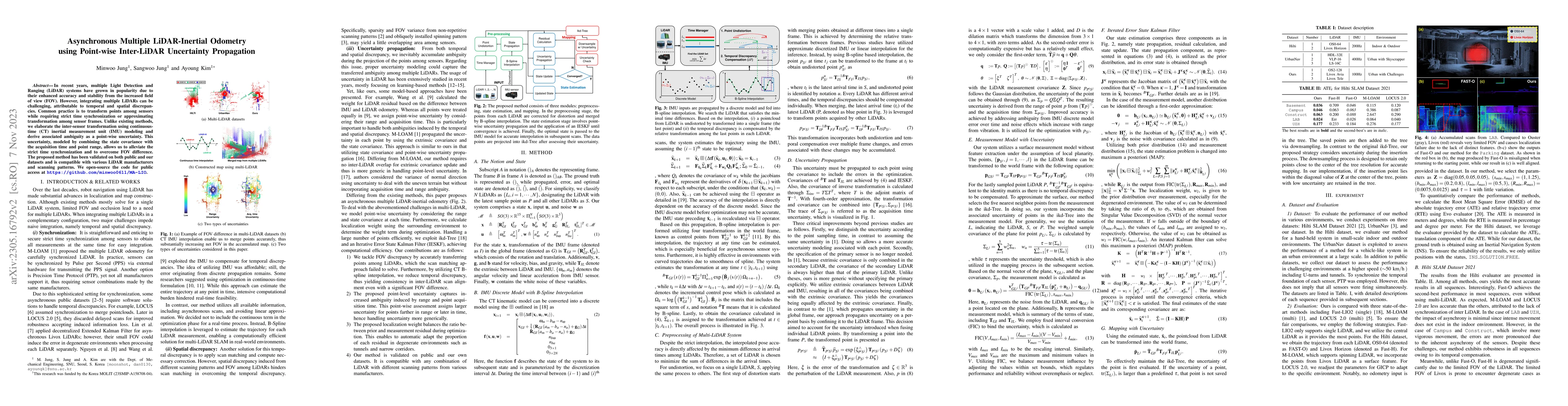
In recent years, multiple Light Detection and Ranging (LiDAR) systems have grown in popularity due to their enhanced accuracy and stability from the increased field of view (FOV). However, integrati...
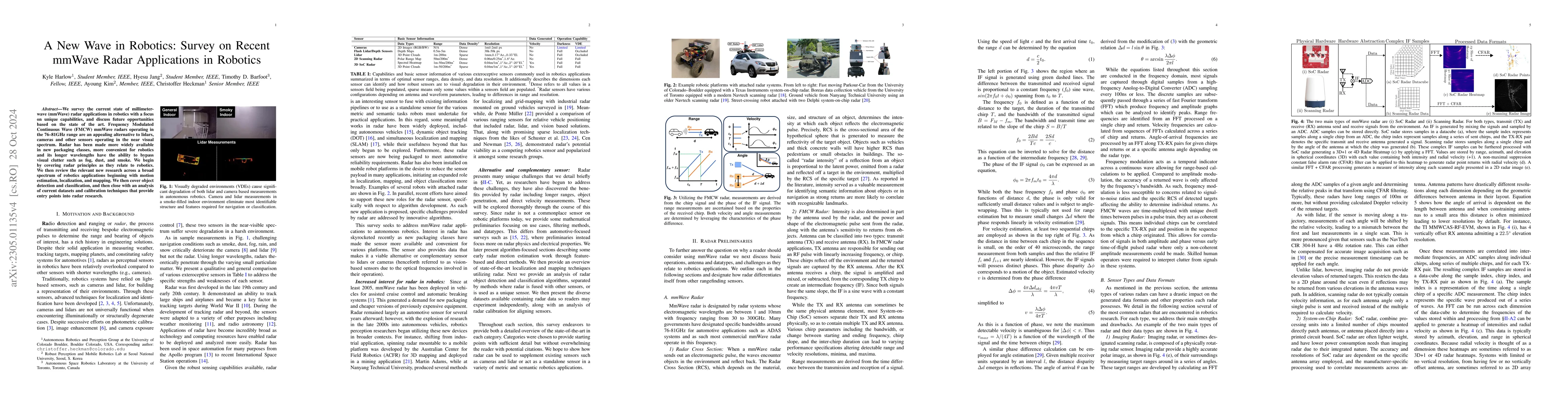
We survey the current state of millimeterwave (mmWave) radar applications in robotics with a focus on unique capabilities, and discuss future opportunities based on the state of the art. Frequency M...
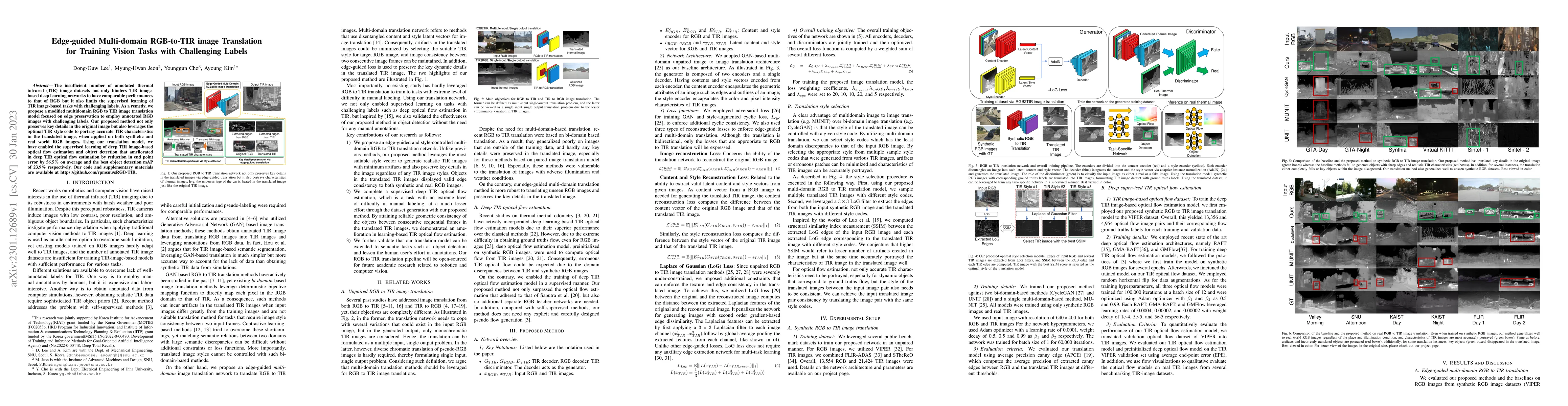
The insufficient number of annotated thermal infrared (TIR) image datasets not only hinders TIR image-based deep learning networks to have comparable performances to that of RGB but it also limits t...
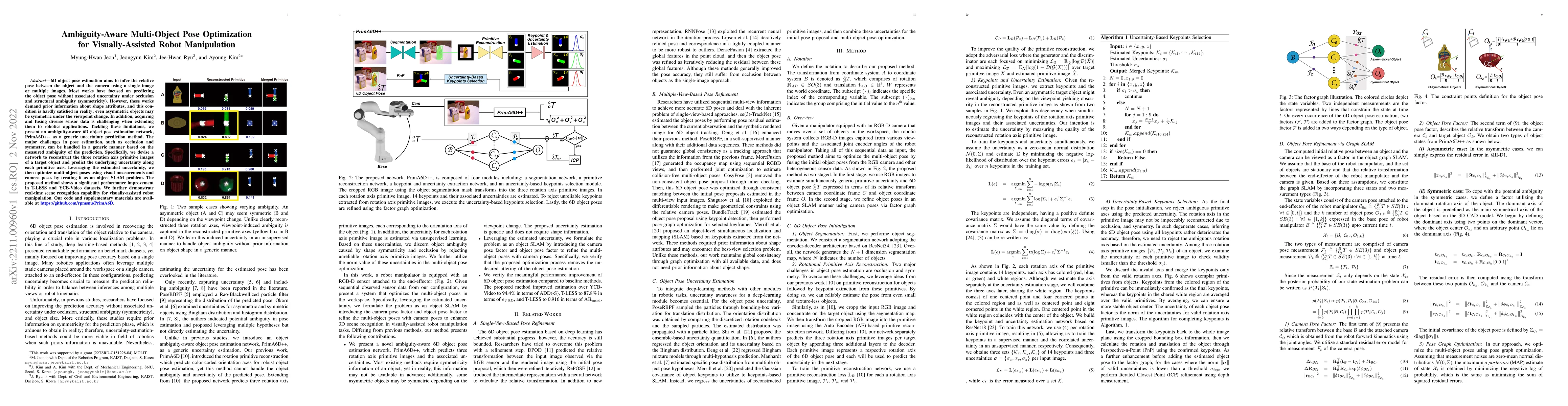
6D object pose estimation aims to infer the relative pose between the object and the camera using a single image or multiple images. Most works have focused on predicting the object pose without ass...
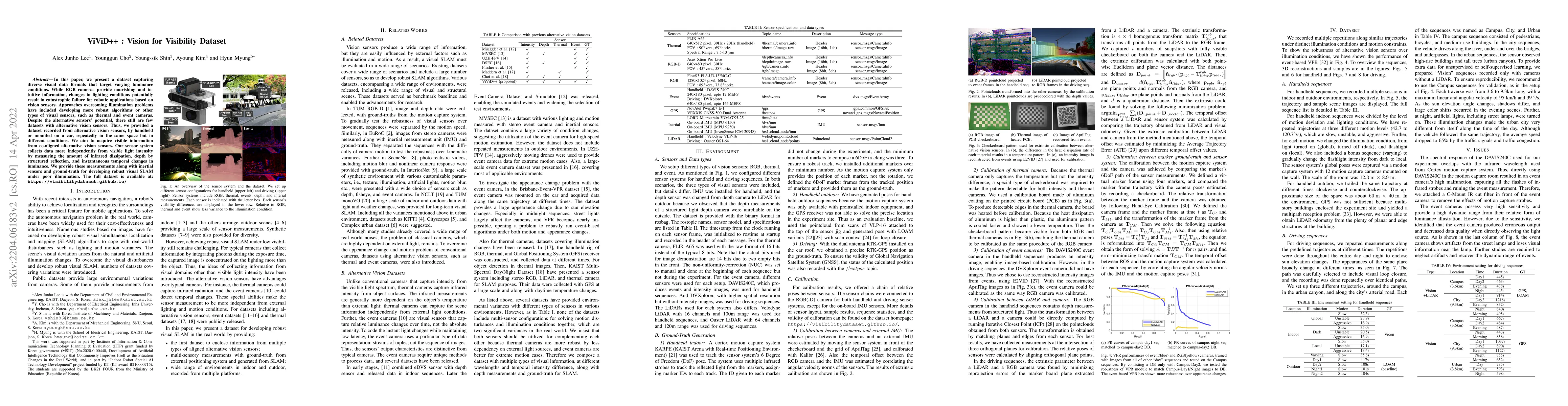
In this paper, we present a dataset capturing diverse visual data formats that target varying luminance conditions. While RGB cameras provide nourishing and intuitive information, changes in lightin...
Accurate 3D point cloud map generation is a core task for various robot missions or even for data-driven urban analysis. To do so, light detection and ranging (LiDAR) sensor-based simultaneous local...
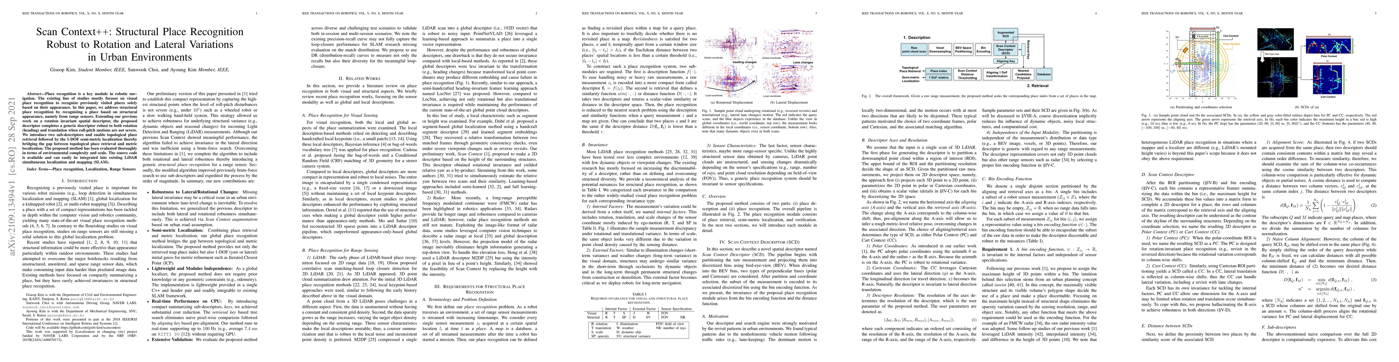
Place recognition is a key module in robotic navigation. The existing line of studies mostly focuses on visual place recognition to recognize previously visited places solely based on their appearan...
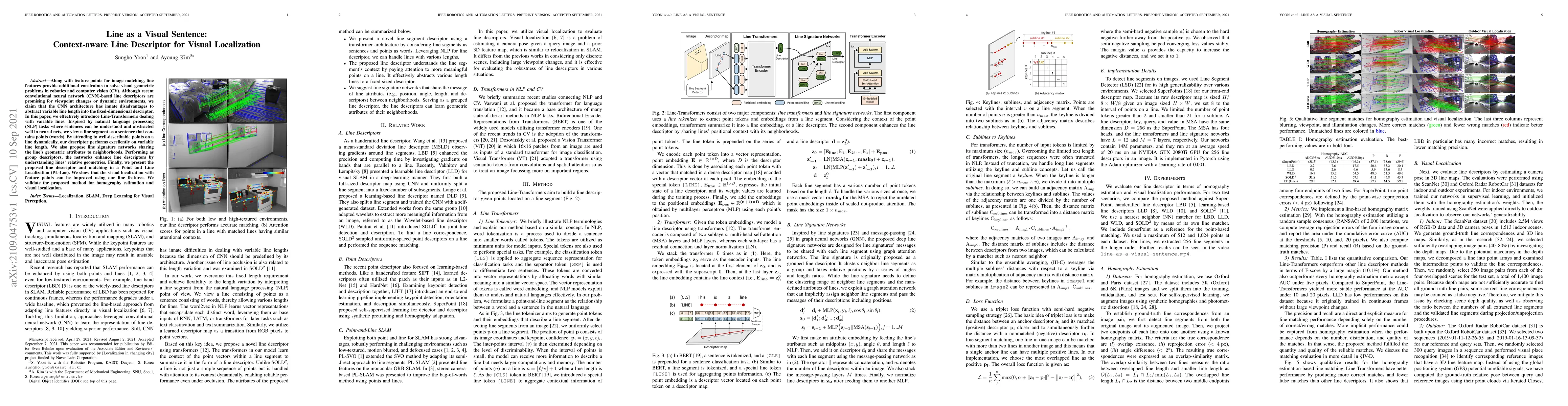
Along with feature points for image matching, line features provide additional constraints to solve visual geometric problems in robotics and computer vision (CV). Although recent convolutional neur...
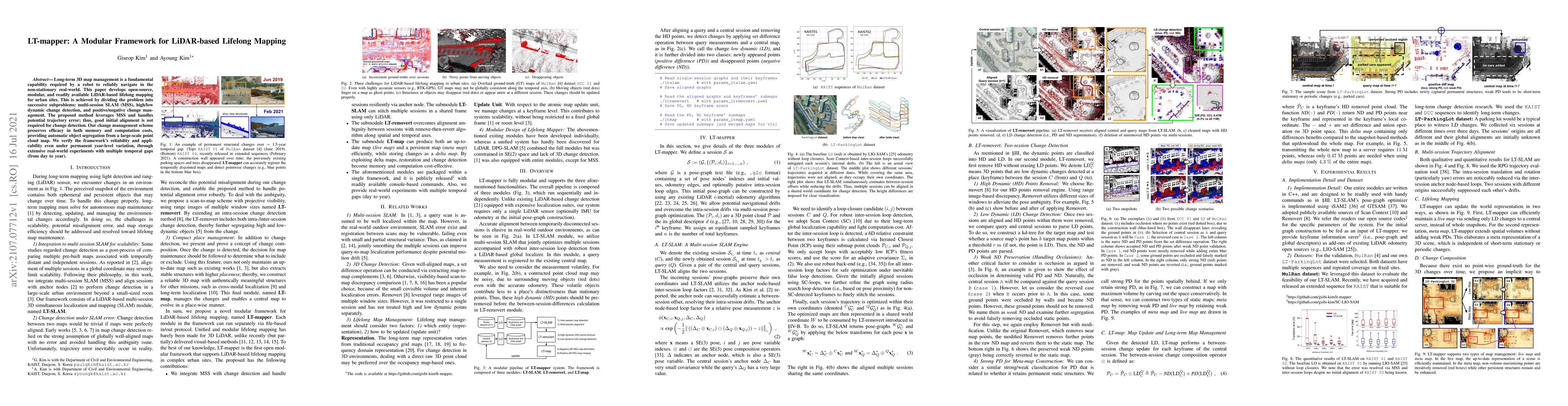
Long-term 3D map management is a fundamental capability required by a robot to reliably navigate in the non-stationary real-world. This paper develops open-source, modular, and readily available LiD...
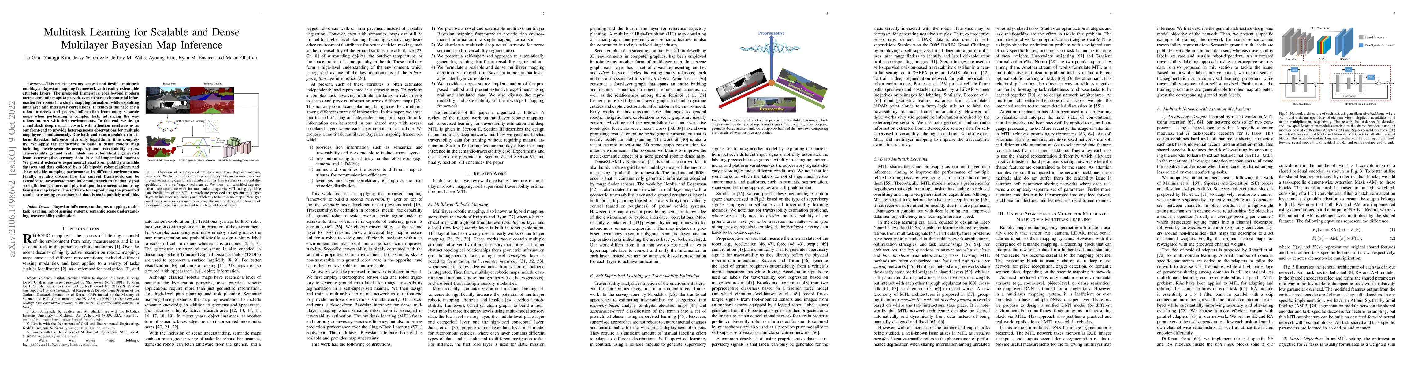
This article presents a novel and flexible multitask multilayer Bayesian mapping framework with readily extendable attribute layers. The proposed framework goes beyond modern metric-semantic maps to...
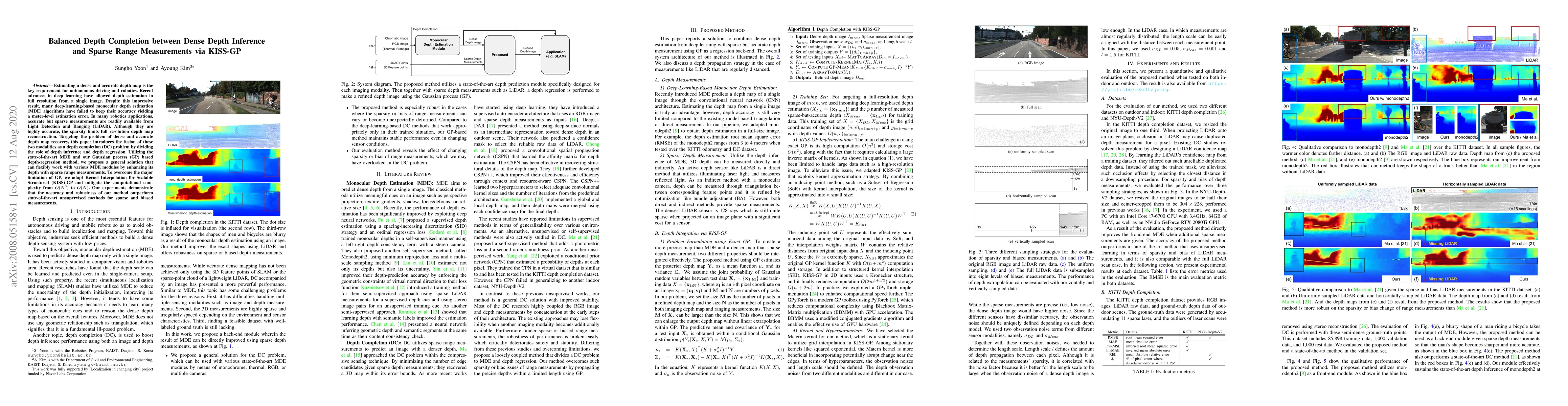
Estimating a dense and accurate depth map is the key requirement for autonomous driving and robotics. Recent advances in deep learning have allowed depth estimation in full resolution from a single ...
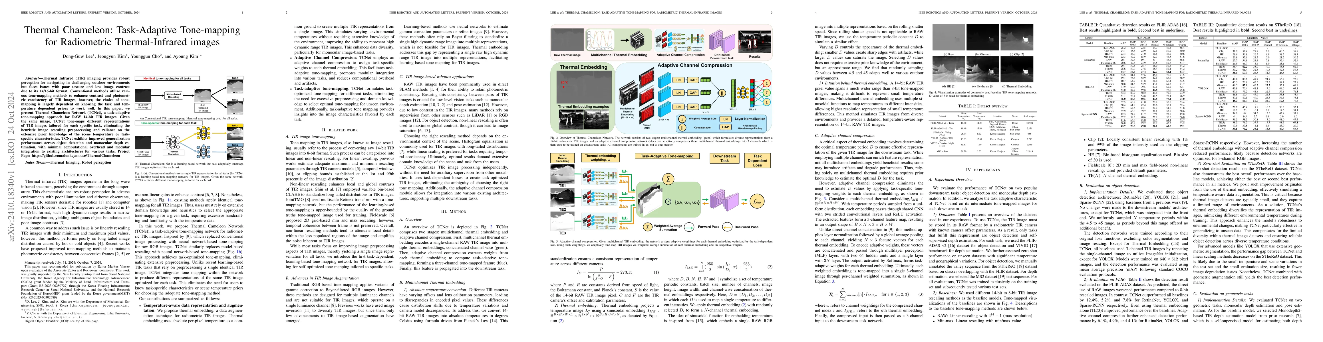
Thermal Infrared (TIR) imaging provides robust perception for navigating in challenging outdoor environments but faces issues with poor texture and low image contrast due to its 14/16-bit format. Conv...
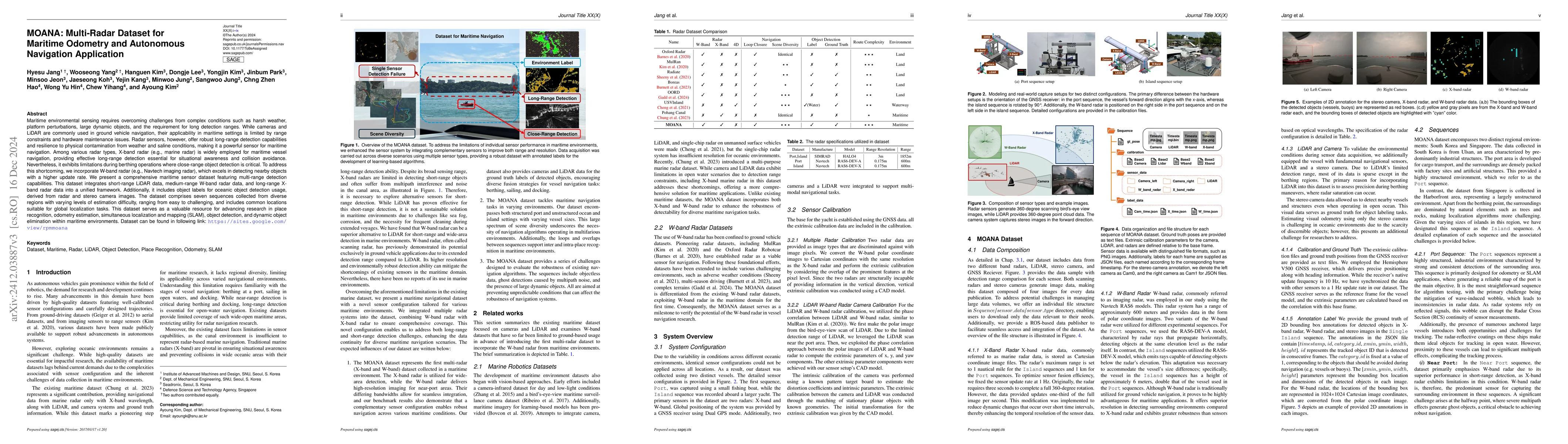
Maritime environmental sensing requires overcoming challenges from complex conditions such as harsh weather, platform perturbations, large dynamic objects, and the requirement for long detection range...
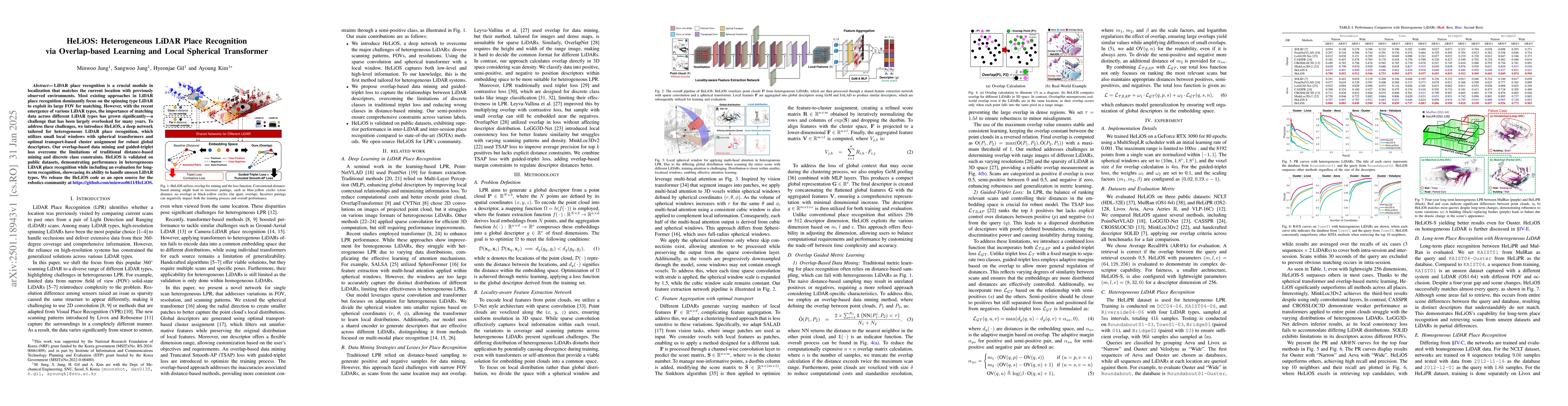
LiDAR place recognition is a crucial module in localization that matches the current location with previously observed environments. Most existing approaches in LiDAR place recognition dominantly focu...
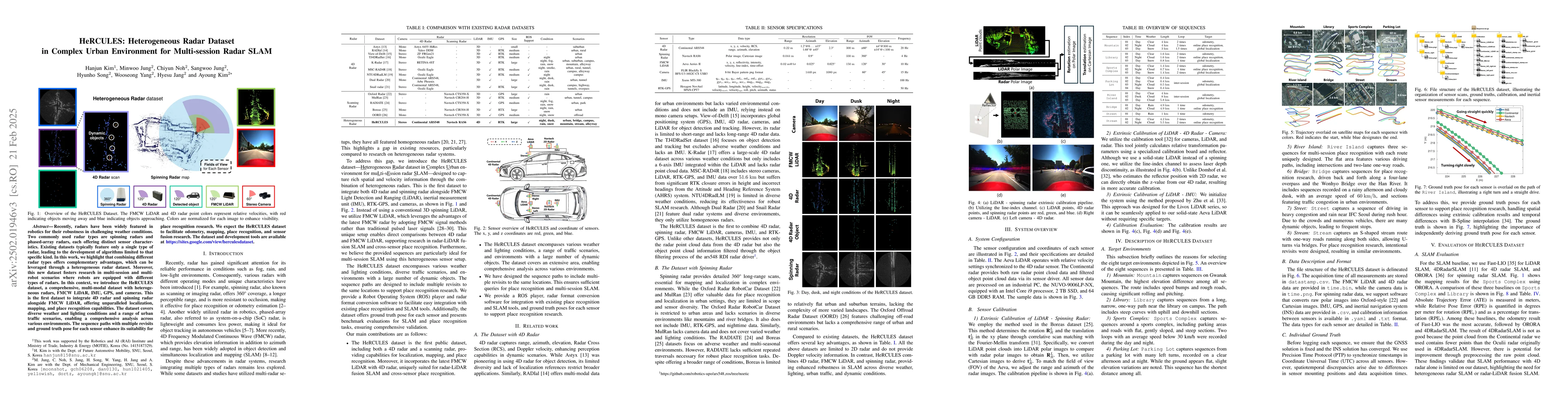
Recently, radars have been widely featured in robotics for their robustness in challenging weather conditions. Two commonly used radar types are spinning radars and phased-array radars, each offering ...
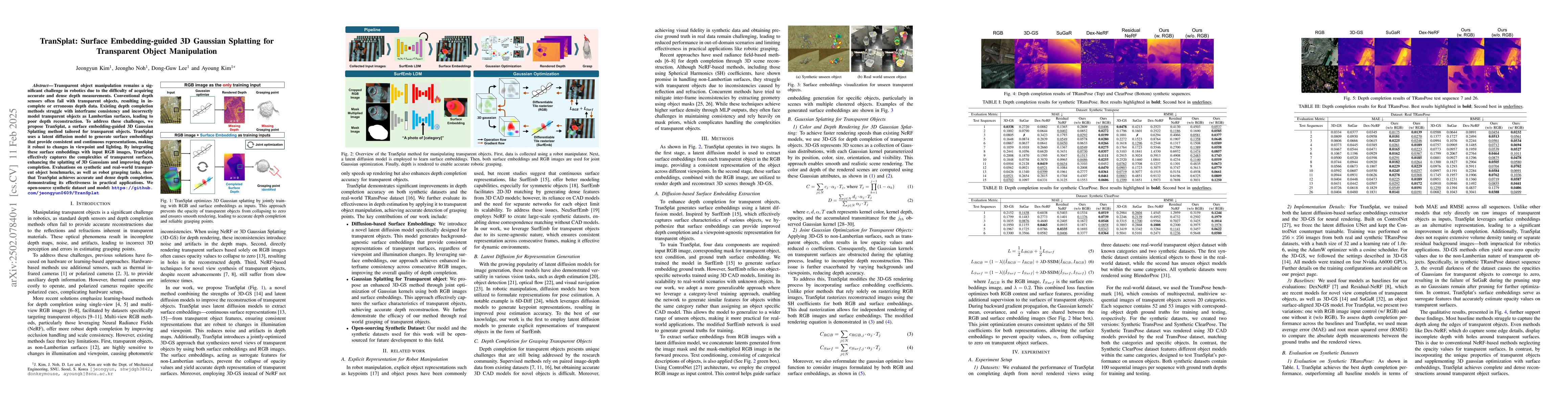
Transparent object manipulation remains a significant challenge in robotics due to the difficulty of acquiring accurate and dense depth measurements. Conventional depth sensors often fail with transpa...
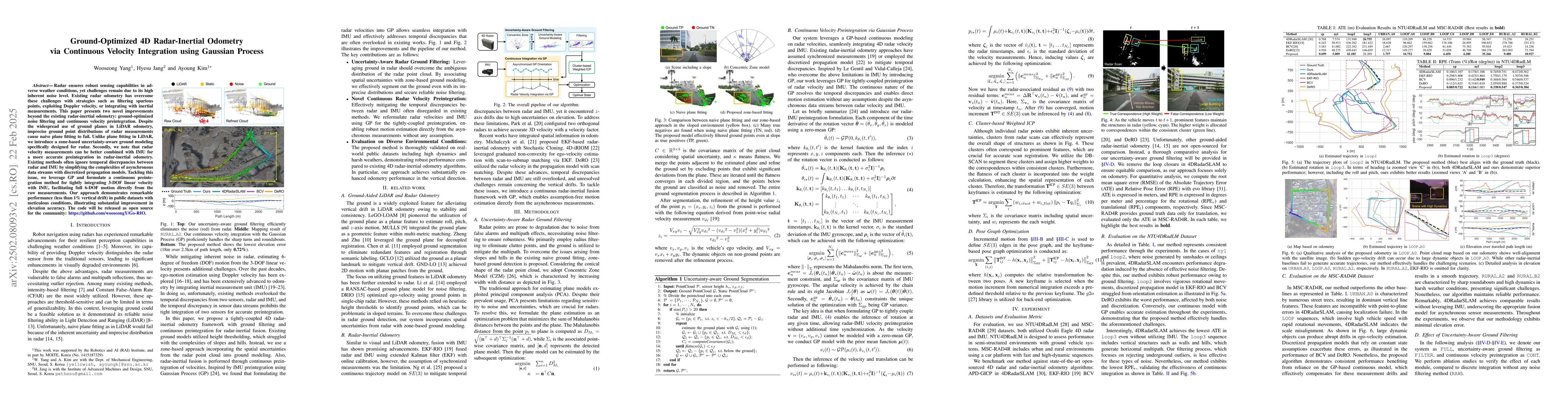
Radar ensures robust sensing capabilities in adverse weather conditions, yet challenges remain due to its high inherent noise level. Existing radar odometry has overcome these challenges with strategi...
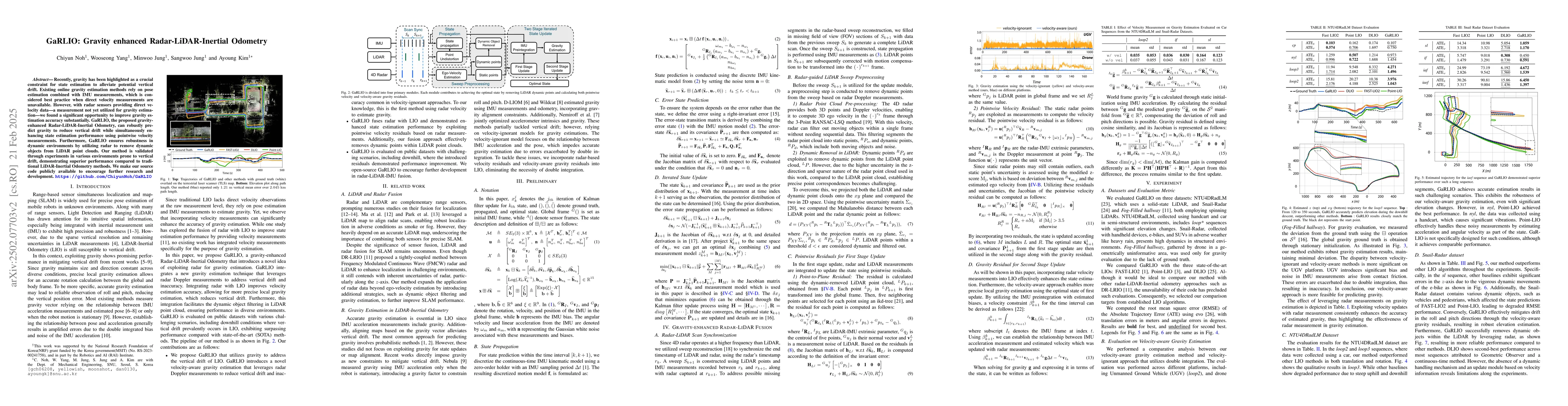
Recently, gravity has been highlighted as a crucial constraint for state estimation to alleviate potential vertical drift. Existing online gravity estimation methods rely on pose estimation combined w...
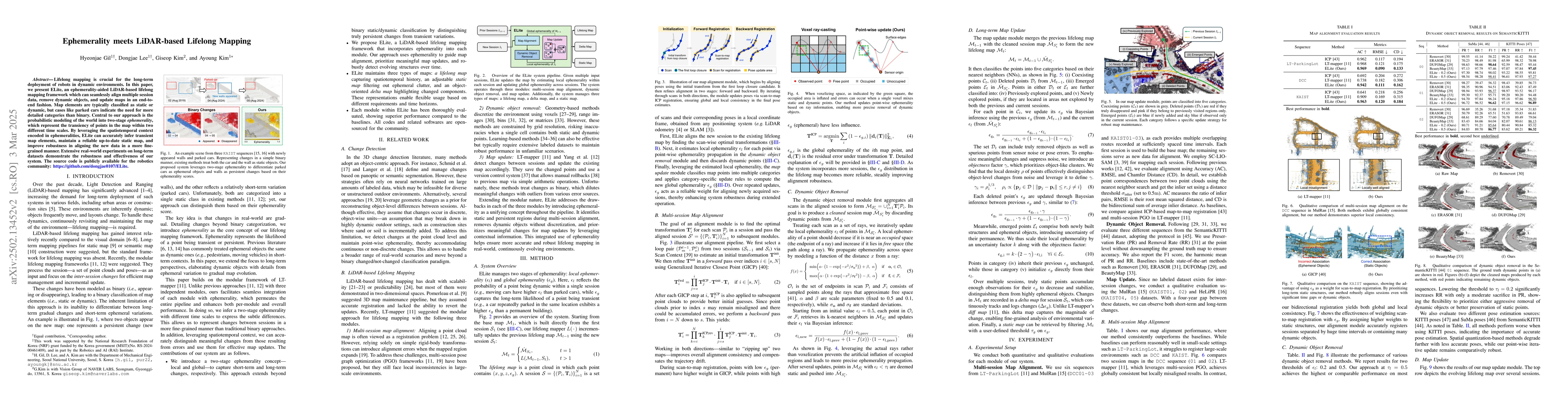
Lifelong mapping is crucial for the long-term deployment of robots in dynamic environments. In this paper, we present ELite, an ephemerality-aided LiDAR-based lifelong mapping framework which can seam...
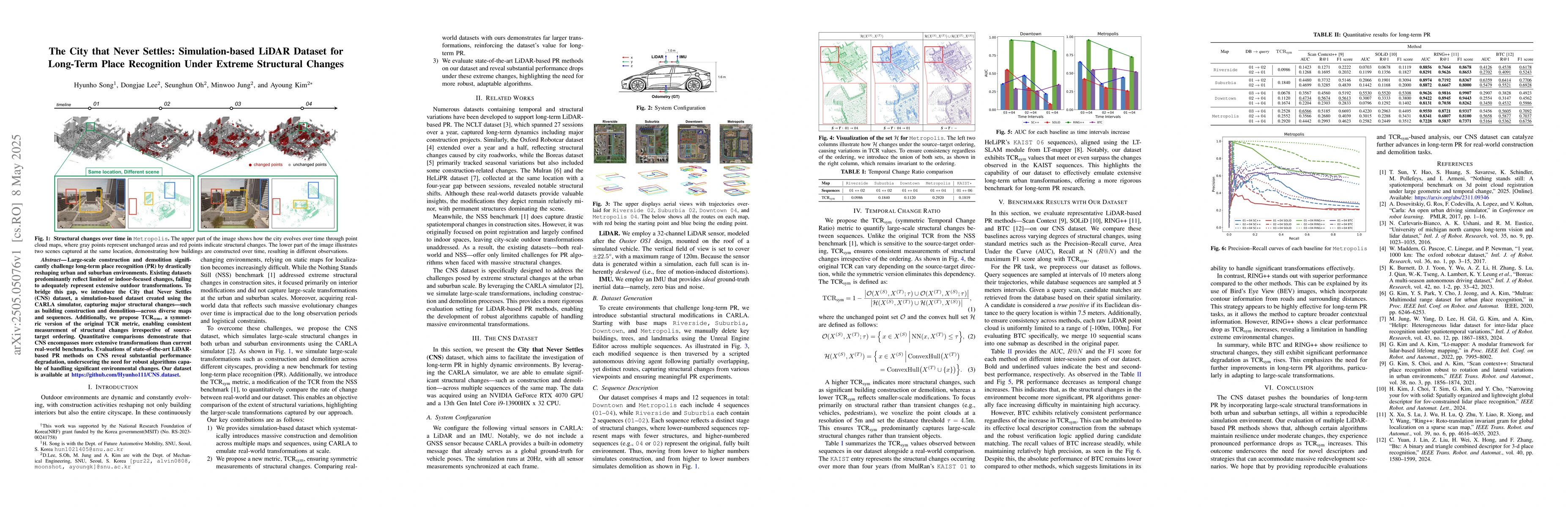
Large-scale construction and demolition significantly challenge long-term place recognition (PR) by drastically reshaping urban and suburban environments. Existing datasets predominantly reflect limit...
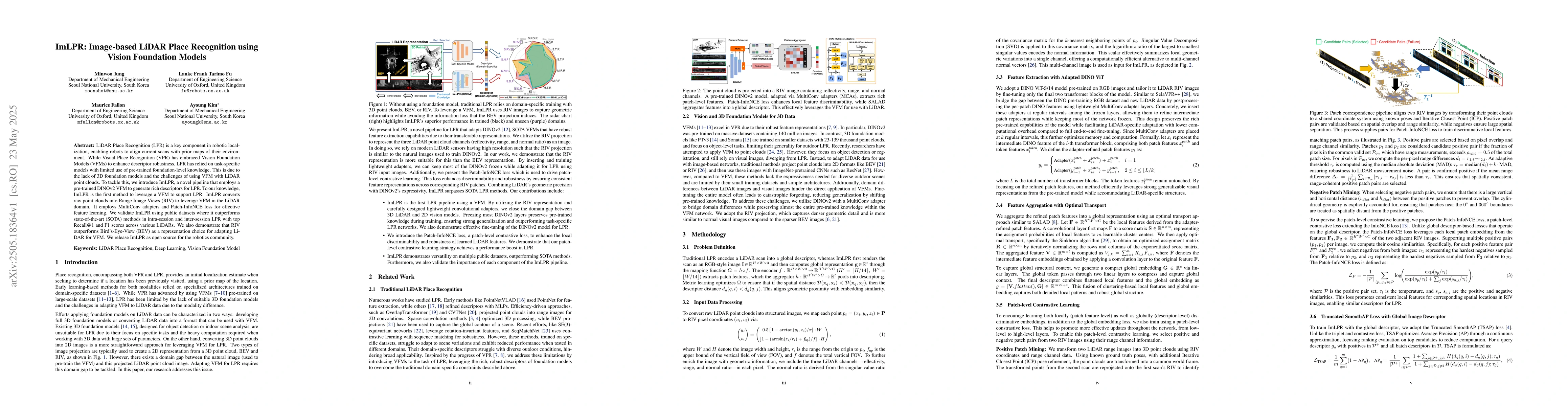
LiDAR Place Recognition (LPR) is a key component in robotic localization, enabling robots to align current scans with prior maps of their environment. While Visual Place Recognition (VPR) has embraced...
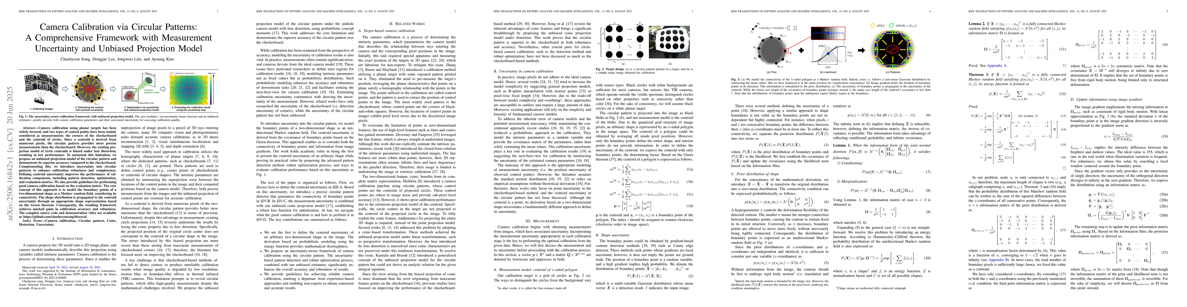
Camera calibration using planar targets has been widely favored, and two types of control points have been mainly considered as measurements: the corners of the checkerboard and the centroid of circle...
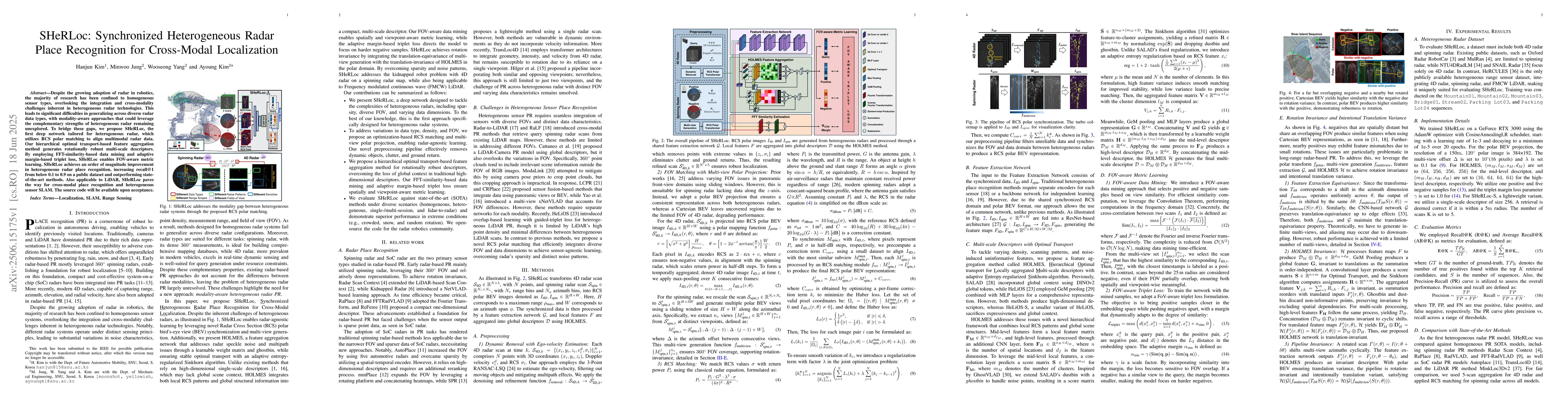
Despite the growing adoption of radar in robotics, the majority of research has been confined to homogeneous sensor types, overlooking the integration and cross-modality challenges inherent in heterog...
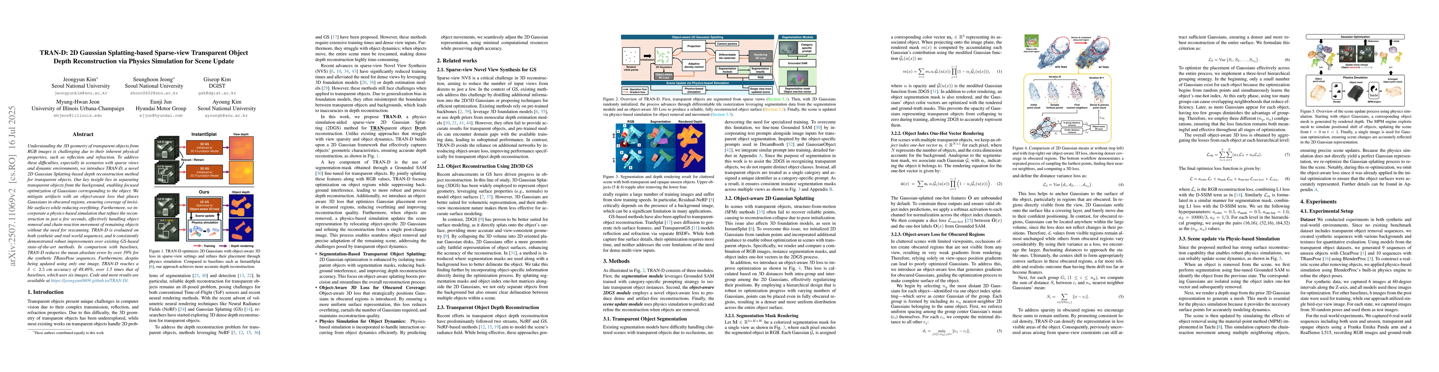
Understanding the 3D geometry of transparent objects from RGB images is challenging due to their inherent physical properties, such as reflection and refraction. To address these difficulties, especia...
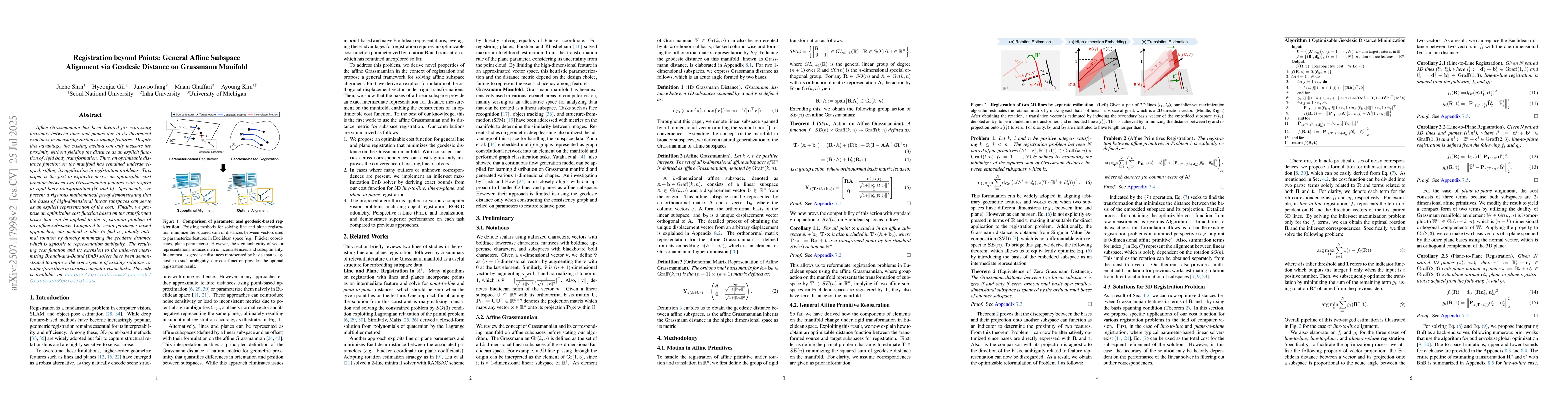
Affine Grassmannian has been favored for expressing proximity between lines and planes due to its theoretical exactness in measuring distances among features. Despite this advantage, the existing meth...
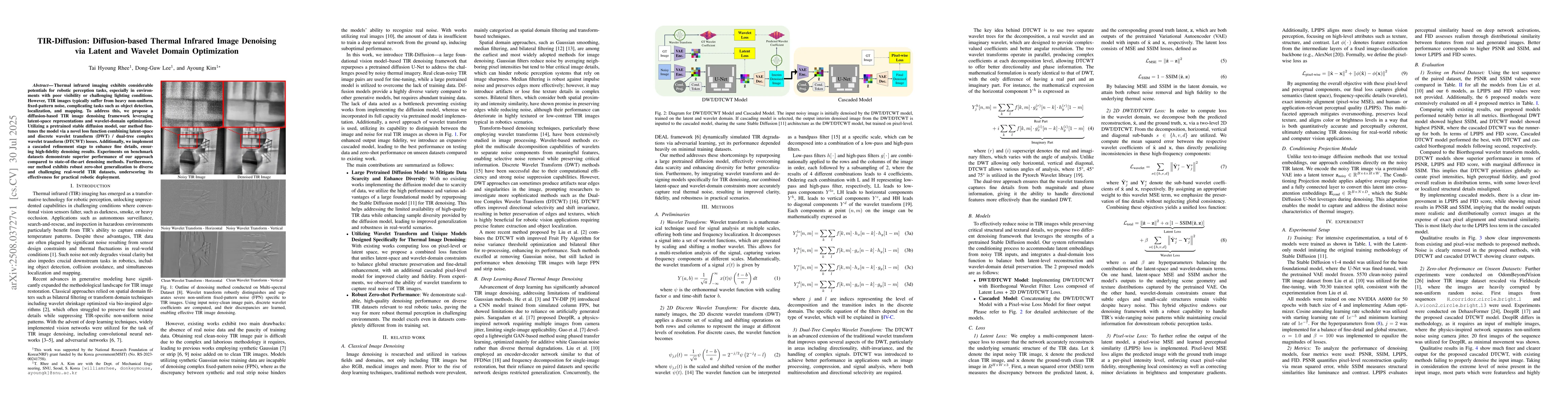
Thermal infrared imaging exhibits considerable potentials for robotic perception tasks, especially in environments with poor visibility or challenging lighting conditions. However, TIR images typicall...
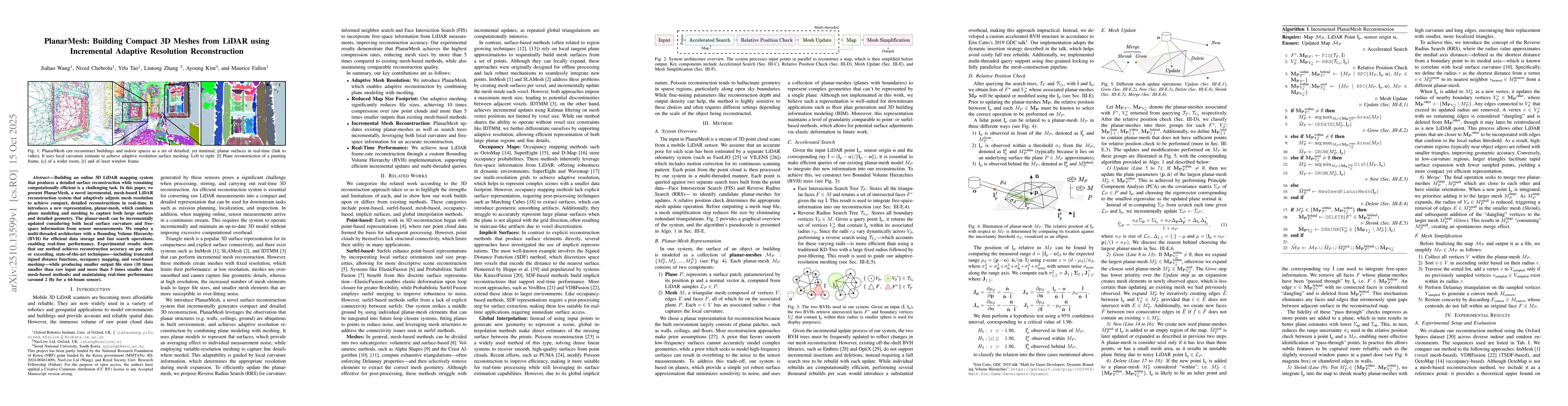
Building an online 3D LiDAR mapping system that produces a detailed surface reconstruction while remaining computationally efficient is a challenging task. In this paper, we present PlanarMesh, a nove...
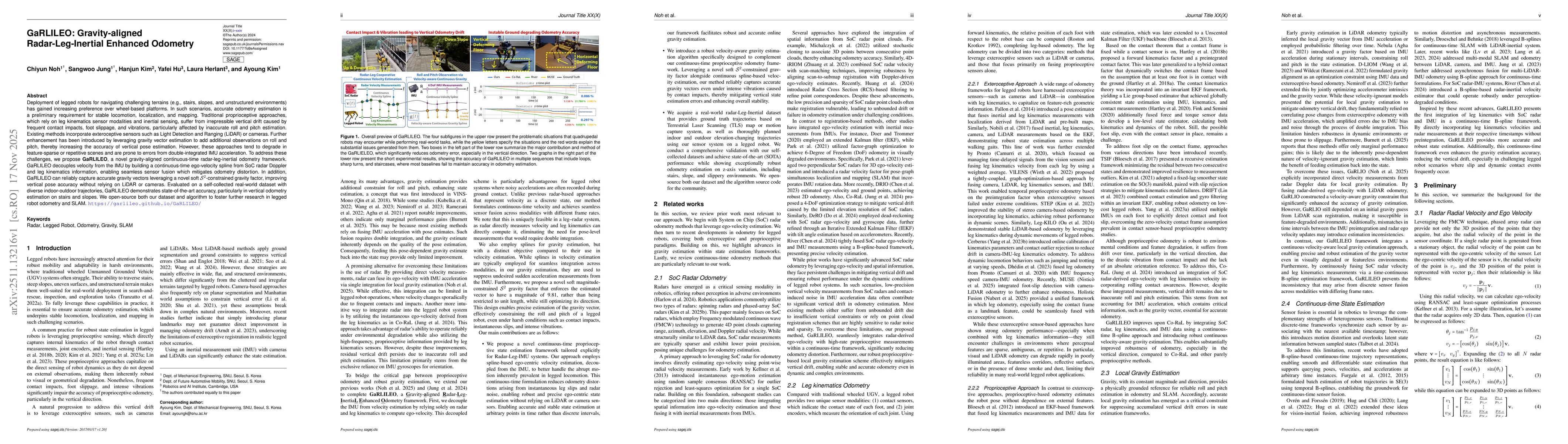
Deployment of legged robots for navigating challenging terrains (e.g., stairs, slopes, and unstructured environments) has gained increasing preference over wheel-based platforms. In such scenarios, ac...
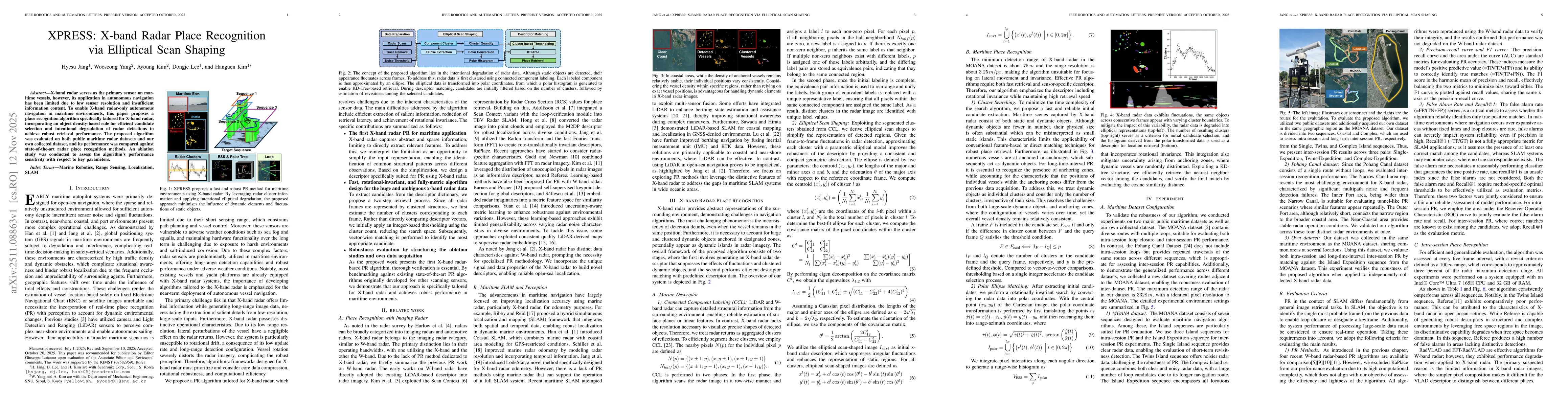
X-band radar serves as the primary sensor on maritime vessels, however, its application in autonomous navigation has been limited due to low sensor resolution and insufficient information content. To ...
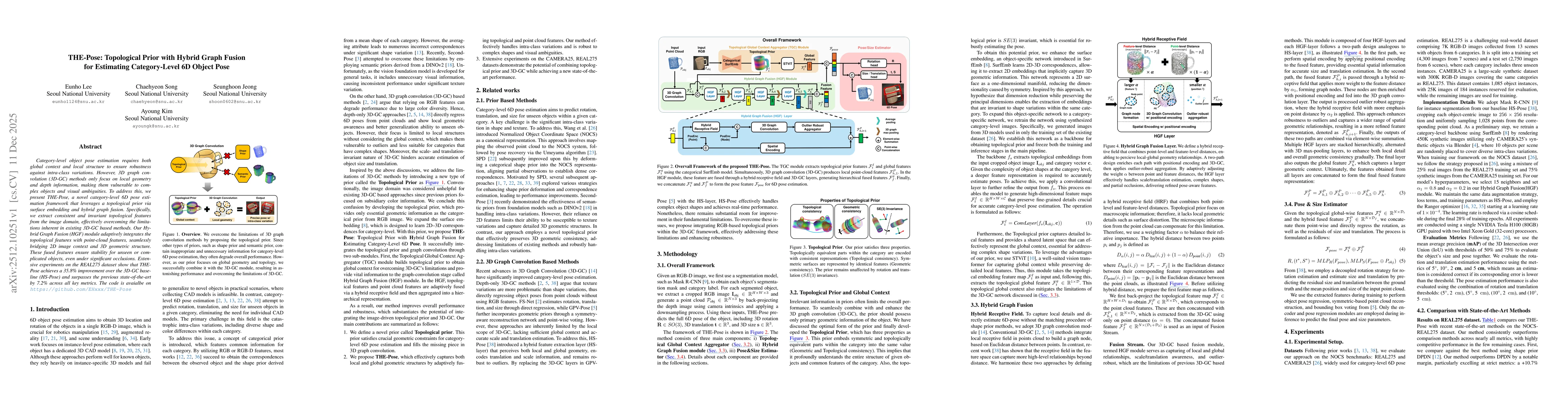
Category-level object pose estimation requires both global context and local structure to ensure robustness against intra-class variations. However, 3D graph convolution (3D-GC) methods only focus on ...
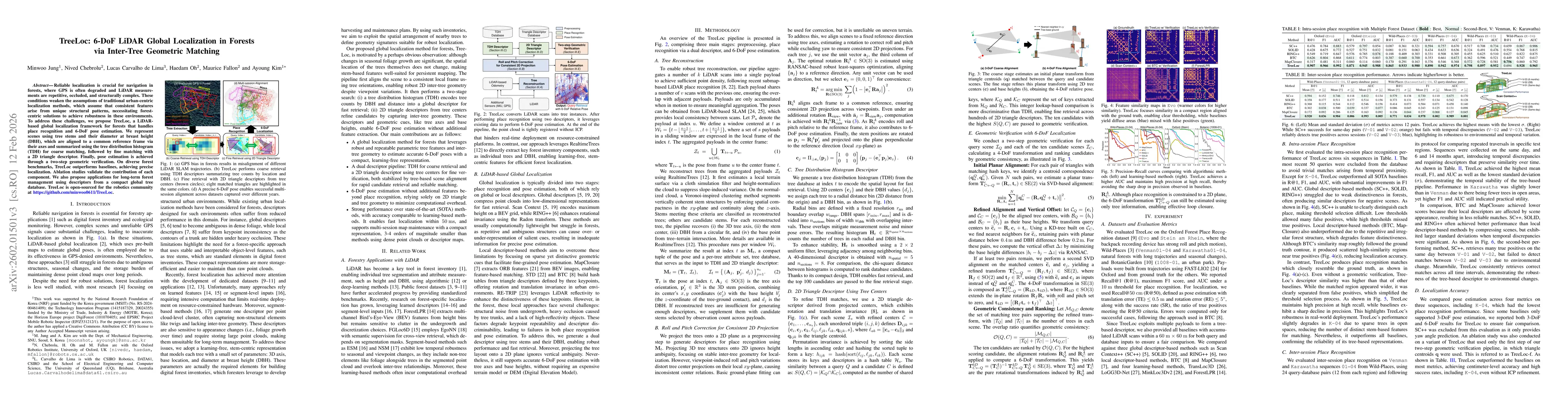
Reliable localization is crucial for navigation in forests, where GPS is often degraded and LiDAR measurements are repetitive, occluded, and structurally complex. These conditions weaken the assumptio...
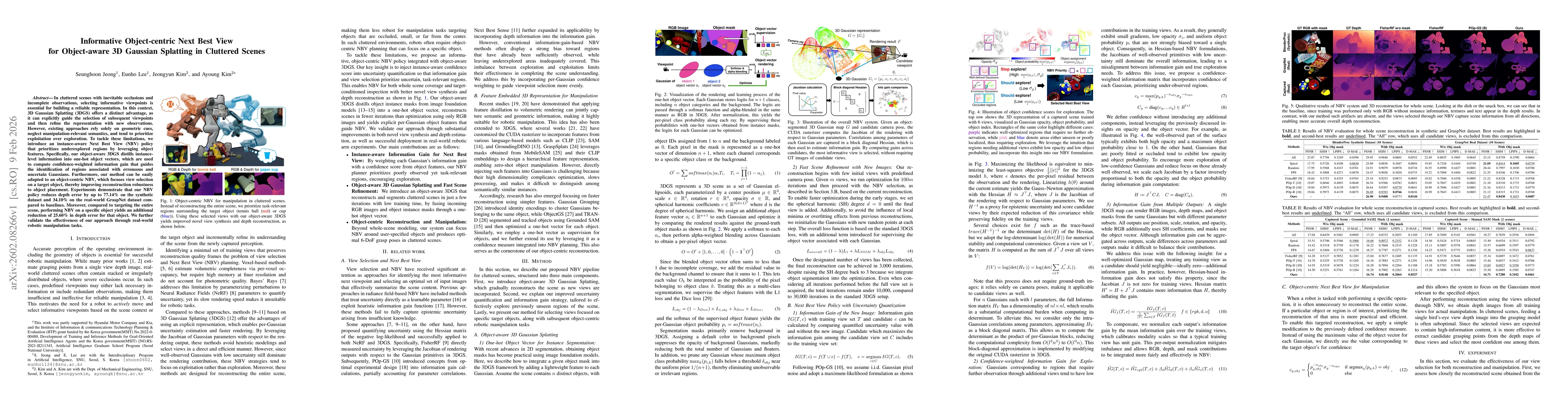
In cluttered scenes with inevitable occlusions and incomplete observations, selecting informative viewpoints is essential for building a reliable representation. In this context, 3D Gaussian Splatting...
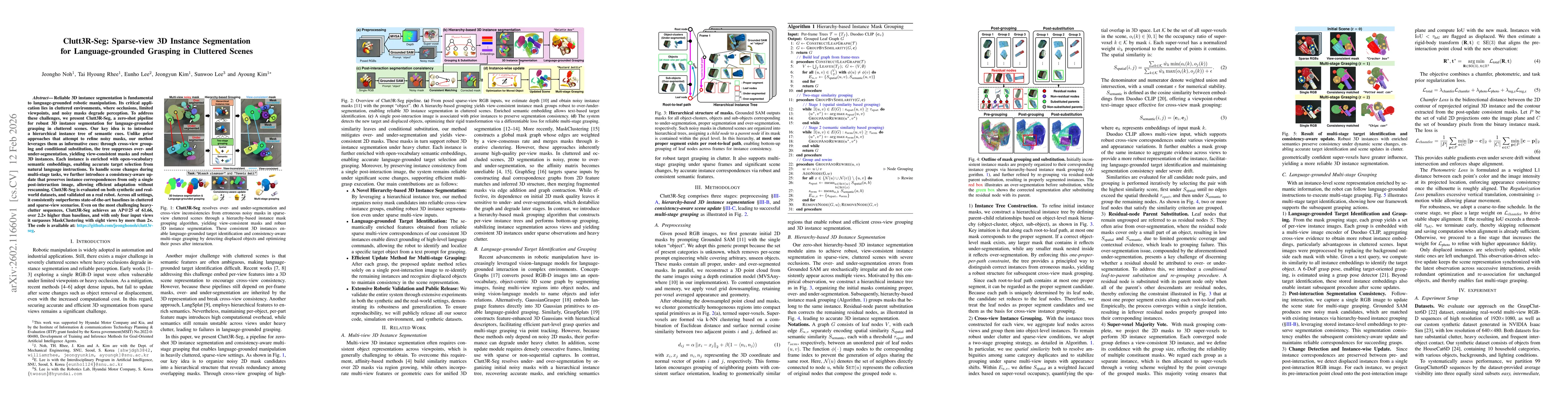
Reliable 3D instance segmentation is fundamental to language-grounded robotic manipulation. Its critical application lies in cluttered environments, where occlusions, limited viewpoints, and noisy mas...
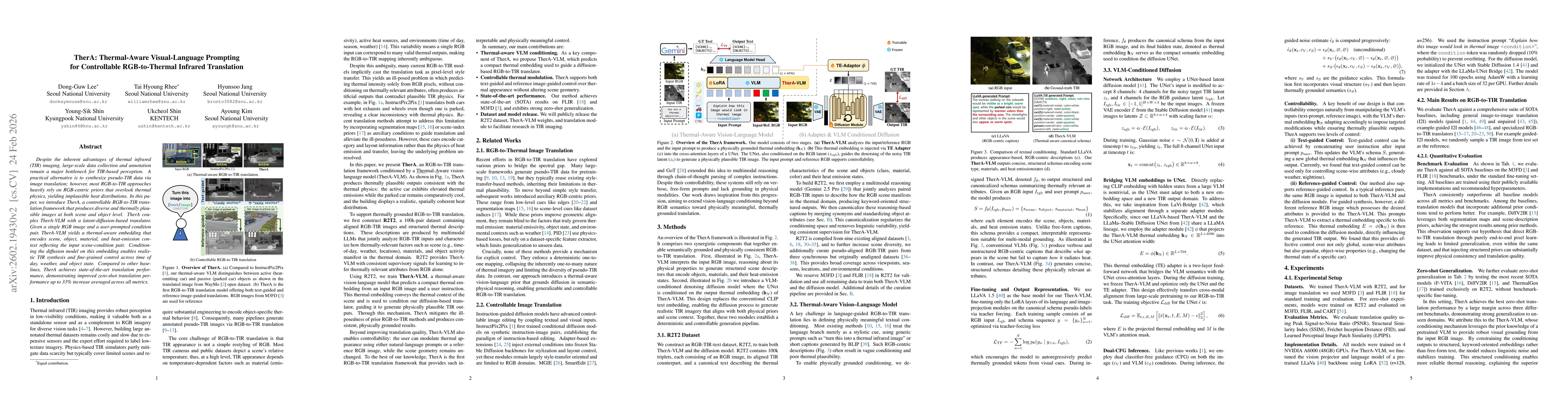
Despite the inherent advantages of thermal infrared(TIR) imaging, large-scale data collection and annotation remain a major bottleneck for TIR-based perception. A practical alternative is to synthesiz...
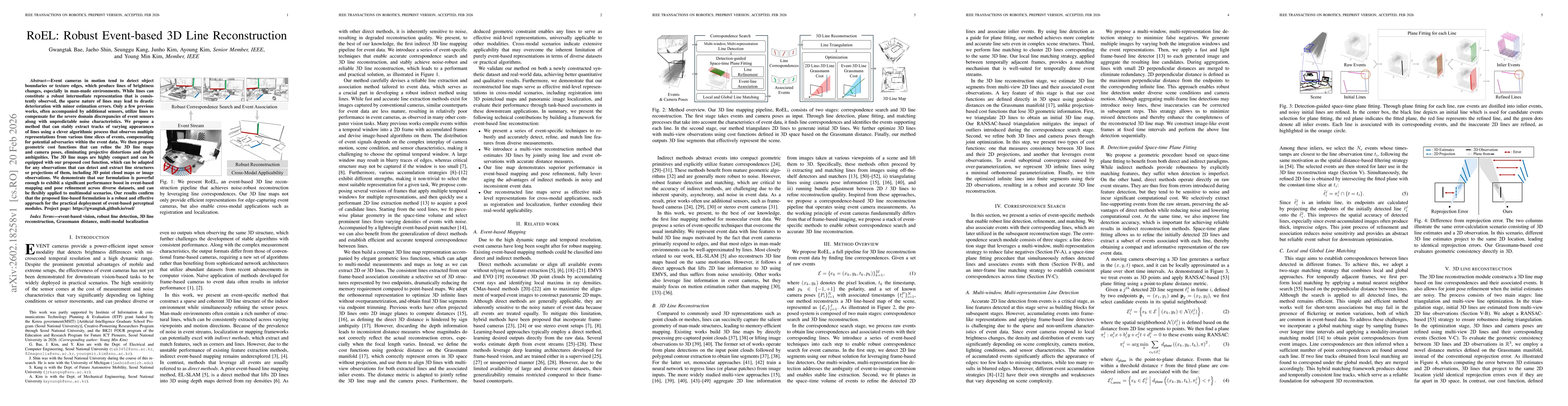
Event cameras in motion tend to detect object boundaries or texture edges, which produce lines of brightness changes, especially in man-made environments. While lines can constitute a robust intermedi...
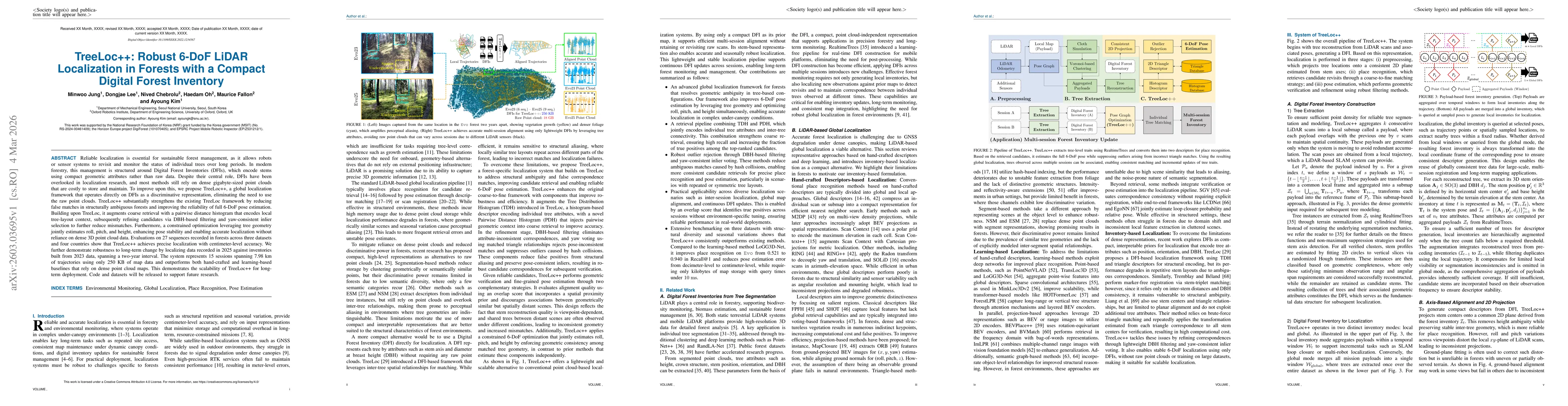
Reliable localization is essential for sustainable forest management, as it allows robots or sensor systems to revisit and monitor the status of individual trees over long periods. In modern forestry,...
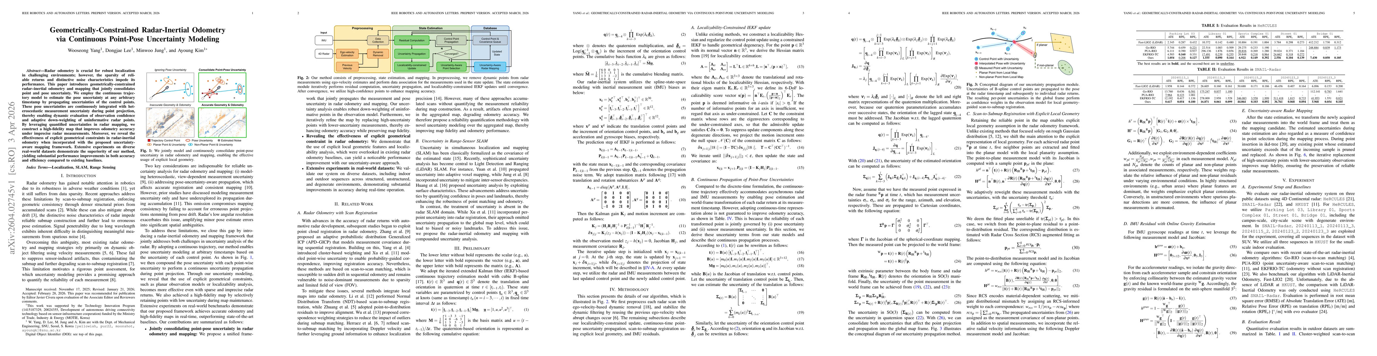
Radar odometry is crucial for robust localization in challenging environments; however, the sparsity of reliable returns and distinctive noise characteristics impede its performance. This paper introd...
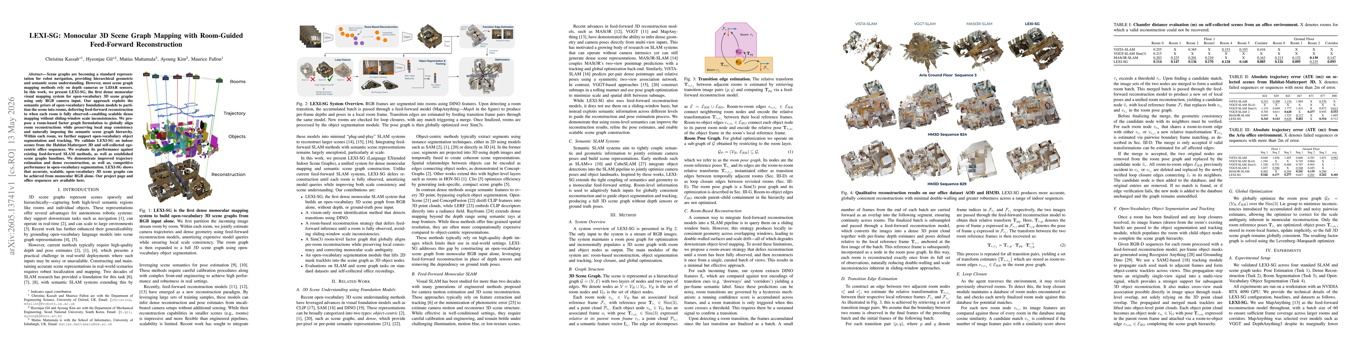
Scene graphs are becoming a standard representation for robot navigation, providing hierarchical geometric and semantic scene understanding. However, most scene graph mapping methods rely on depth cam...
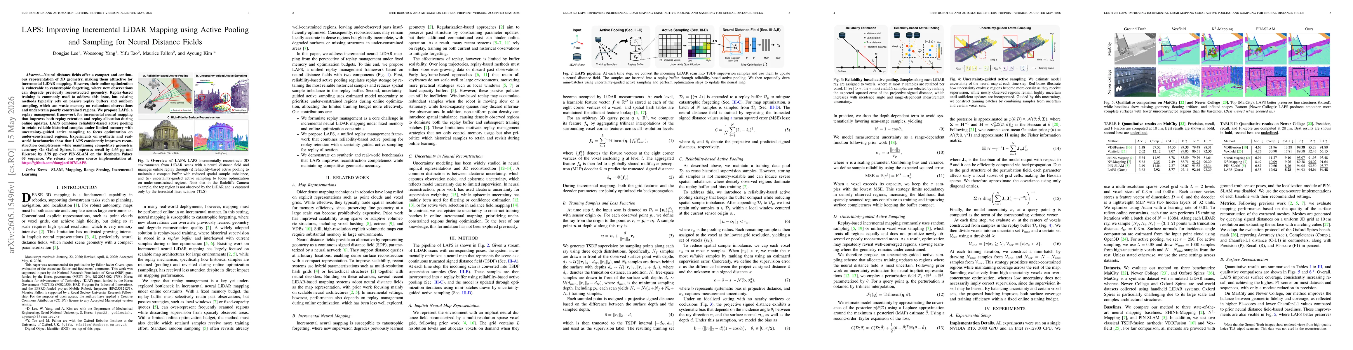
Neural distance fields offer a compact and continuous representation of 3D geometry, making them attractive for incremental LiDAR mapping. However, their online optimization is vulnerable to catastrop...
Legged robots carry an IMU, but the inertial solution drifts because consumer-grade IMUs are noisy. However, the feet create intermittent contacts with the environment that can be used to mitigate tha...
Thermal infrared (TIR) imaging has been a popular choice for field robotics due to its robust perception capability under low light visual degradation, but it suffers from severe stochastic and fixed-...
Extrinsic calibration of multi-camera systems with non-overlapping FOVs has been a challenging problem in the robotics literature. Conventional target-based methods impose substantial target setup ove...
Standard stereo VIO focuses exclusively on the benefit of metric scale via single-spectrum baselines, often overlooking the risks of spectral redundancy. This structural limitation leads to correlated...