Ben Seiyon Lee

10 papers on arXiv

Academic Profile

Name: Seiyon Lee
Total Papers: 11

Statistics

arXiv Papers 10
Total Publications 11

Papers on arXiv

Thumbnail for A Variational Approach for Modeling High-dimensional Spatial Generalized
  Linear Mixed Models

A Variational Approach for Modeling High-dimensional Spatial Generalized Linear Mixed Models

Gaussian and discrete non-Gaussian spatial datasets are prevalent across many fields such as public health, ecology, geosciences, and social sciences. Bayesian spatial generalized linear mixed model...

Thumbnail for A Class of Models for Large Zero-inflated Spatial Data

A Class of Models for Large Zero-inflated Spatial Data

Spatially correlated data with an excess of zeros, usually referred to as zero-inflated spatial data, arise in many disciplines. Examples include count data, for instance, abundance (or lack thereof...

Thumbnail for Flood hazard model calibration using multiresolution model output

Flood hazard model calibration using multiresolution model output

Riverine floods pose a considerable risk to many communities. Improving flood hazard projections has the potential to inform the design and implementation of flood risk management strategies. Curren...

Thumbnail for Effects of Mixed Distribution Statistical Flood Frequency Models on Dam
  Safety Assessments: A Case Study of the Pueblo Dam, USA

Effects of Mixed Distribution Statistical Flood Frequency Models on Dam Safety Assessments: A Case Study of the Pueblo Dam, USA

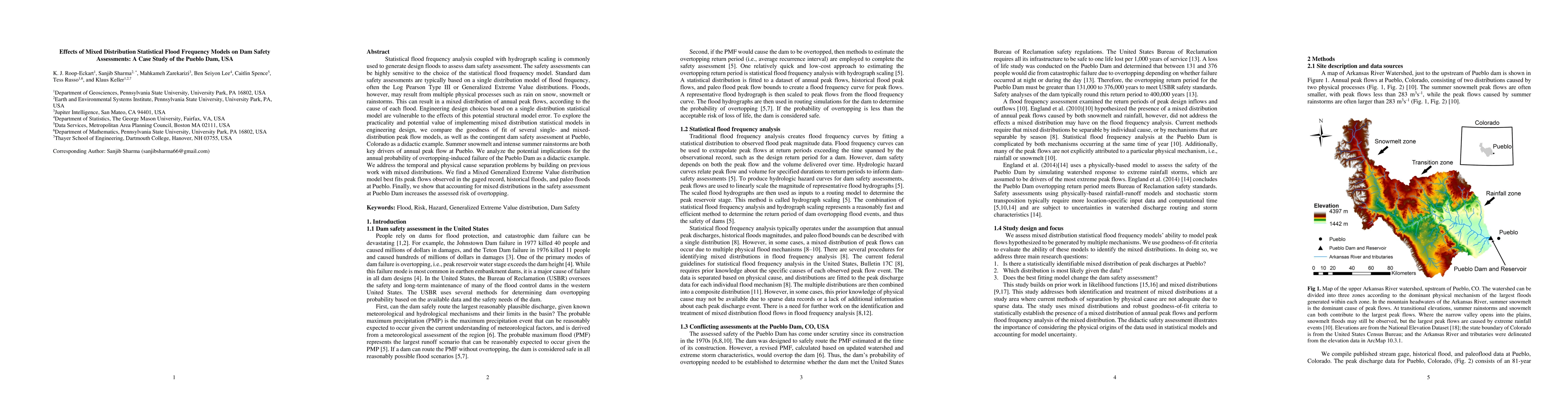
Statistical flood frequency analysis coupled with hydrograph scaling is commonly used to generate design floods to assess dam safety assessment. The safety assessments can be highly sensitive to the...

Thumbnail for A safety factor approach to designing urban infrastructure for dynamic
  conditions

A safety factor approach to designing urban infrastructure for dynamic conditions

Current approaches to design flood-sensitive infrastructure typically assume a stationary rainfall distribution and neglect many uncertainties. These assumptions are inconsistent with observations t...

Thumbnail for Bayesian Spatiotemporal Nonstationary Model Quantifies Robust Increases
  in Daily Extreme Rainfall Across the Western Gulf Coast

Bayesian Spatiotemporal Nonstationary Model Quantifies Robust Increases in Daily Extreme Rainfall Across the Western Gulf Coast

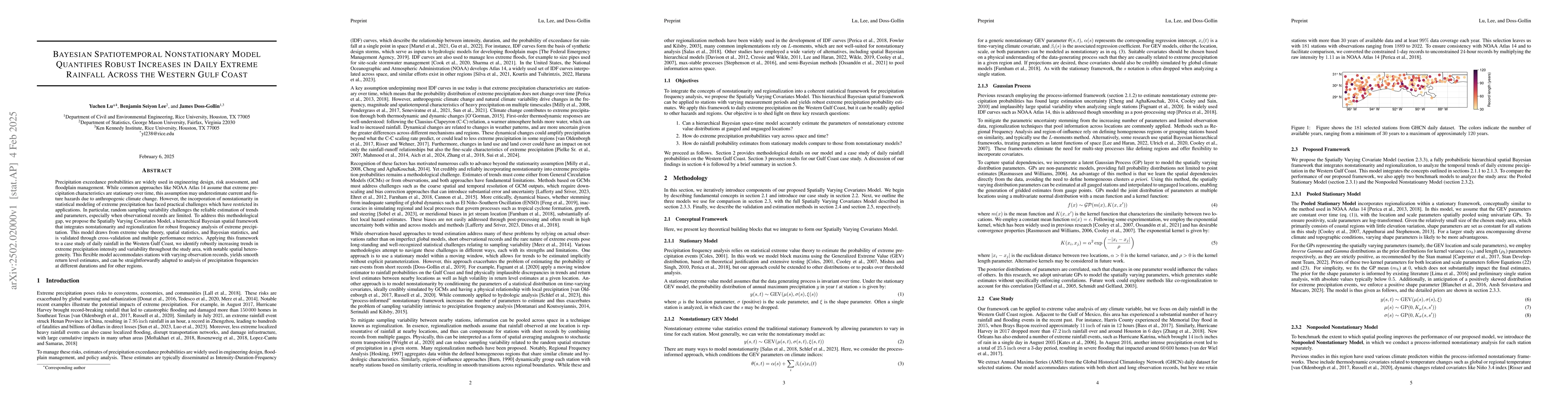
Precipitation exceedance probabilities are widely used in engineering design, risk assessment, and floodplain management. While common approaches like NOAA Atlas 14 assume that extreme precipitation c...

Thumbnail for A Scalable Variational Bayes Approach for Fitting Non-Conjugate Spatial Generalized Linear Mixed Models via Basis Expansions

A Scalable Variational Bayes Approach for Fitting Non-Conjugate Spatial Generalized Linear Mixed Models via Basis Expansions

Large spatial datasets with non-Gaussian responses are increasingly common in environmental monitoring, ecology, and remote sensing, yet scalable Bayesian inference for such data remains challenging. ...

Thumbnail for Spatial Extremes at Scale: A Case Study of Surface Skin Temperature and Heat Risk in the United States

Spatial Extremes at Scale: A Case Study of Surface Skin Temperature and Heat Risk in the United States

Understanding and mapping extreme heat is critical for risk management and public health planning, particularly in regions with complex terrain and heterogeneous climate. We present a case study of ex...

Thumbnail for REX-SUB: A Scalable Subsampling Strategy for Modeling Large Spatial Datasets

REX-SUB: A Scalable Subsampling Strategy for Modeling Large Spatial Datasets

Recent advances in data collection technologies have led to the emergence of massive spatial datasets, with measurements obtained at millions of spatial locations. Geostatistical models typically empl...

Thumbnail for A Cubing Strategy for Identifying Stable Hyperparameter Regions for Uncertainty Quantification in Spatial Deep Learning

A Cubing Strategy for Identifying Stable Hyperparameter Regions for Uncertainty Quantification in Spatial Deep Learning

Spatially referenced datasets have become increasingly prevalent across many fields, largely driven by advances in data collection methods such as satellite remote sensing. In many applications, predi...

This website uses cookies to ensure you get the best experience. Learn more