Changjie Chen

10 papers on arXiv

Academic Profile

Name: Chang-you Chen
Total Papers: 5

Statistics

arXiv Papers 10
Total Publications 5

Papers on arXiv

Thumbnail for Integrating urban digital twins with cloud-based geospatial dashboards
  for coastal resilience planning: A case study in Florida

Integrating urban digital twins with cloud-based geospatial dashboards for coastal resilience planning: A case study in Florida

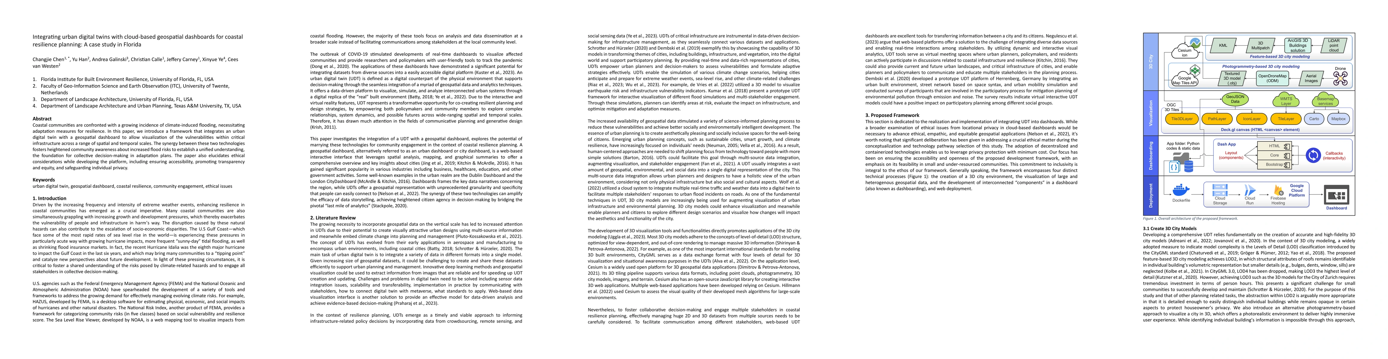
Coastal communities are confronted with a growing incidence of climate-induced flooding, necessitating adaptation measures for resilience. In this paper, we introduce a framework that integrates an ...

Thumbnail for Defining sequences for fundamental root systems and Coxeter graphs for
  super Weyl groups

Defining sequences for fundamental root systems and Coxeter graphs for super Weyl groups

The purpose of this paper is double. One is to introduce defining sequences which are a kind of new descriptions of fundamental root systems for classical Lie superalgebras of type $A,B,C$ and $D$. ...

Thumbnail for No low index critical points for the systole function and sys_T
  functions in large M_{g,n}

No low index critical points for the systole function and sys_T functions in large M_{g,n}

We show for each $k$, any critical point for the $C^2$-Morse function $\syst$ or the systole function that is topologically Morse on $\mathcal M_{g,n}$ has index greater than $k$ when $g$ or $n$ is ...

Thumbnail for C^2-Morse Functions on the Deligne-Mumford compactification of the
  moduli space M_{g,n} bar

C^2-Morse Functions on the Deligne-Mumford compactification of the moduli space M_{g,n} bar

We construct a series of C^2-Morse functions on the Deligne-Mumford compactification M_{g,n} bar of the moduli space of genus g Riemann/hyperbolic surfaces with n punctures. This series of functions...

Thumbnail for PyLUSAT: An open-source Python toolkit for GIS-based land use
  suitability analysis

PyLUSAT: An open-source Python toolkit for GIS-based land use suitability analysis

Desktop GIS applications, such as ArcGIS and QGIS, provide tools essential for conducting suitability analysis, an activity that is central in formulating a land-use plan. But, when it comes to buil...

Thumbnail for Diff4VS: HIV-inhibiting Molecules Generation with Classifier Guidance
  Diffusion for Virtual Screening

Diff4VS: HIV-inhibiting Molecules Generation with Classifier Guidance Diffusion for Virtual Screening

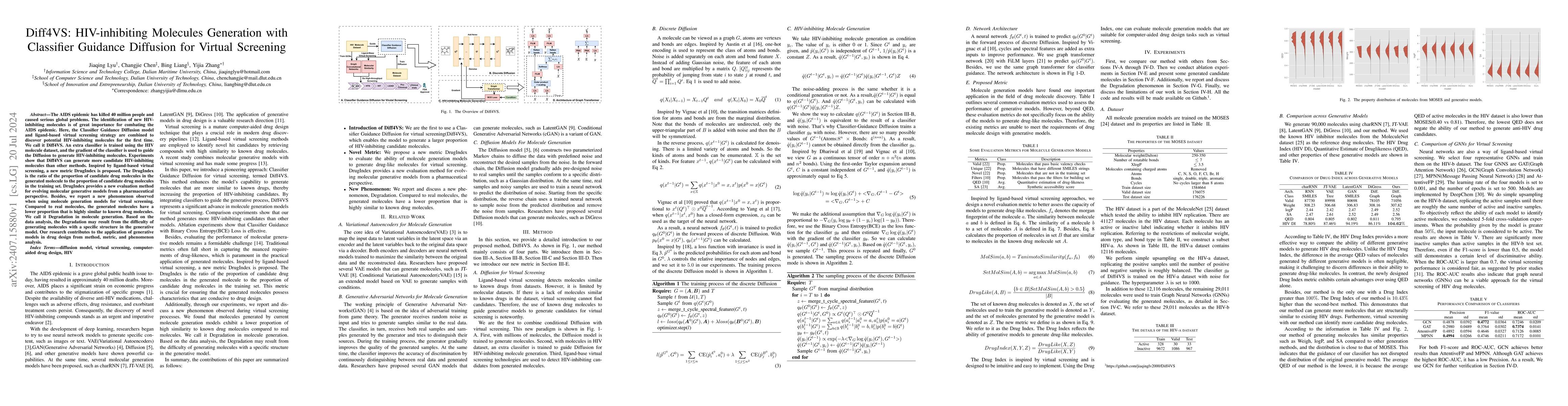
The AIDS epidemic has killed 40 million people and caused serious global problems. The identification of new HIV-inhibiting molecules is of great importance for combating the AIDS epidemic. Here, the ...

Thumbnail for Stability phenomena in Deligne-Mumford compactifications via Morse theory

Stability phenomena in Deligne-Mumford compactifications via Morse theory

We study the rational homology of the Deligne-Mumford compactification $\overline{\mathcal M}_{g,n}$ of the moduli space of stable curves via a family of Morse functions, the $\text{sys}_T$ functions,...

Thumbnail for Shortest k-Geodesics on Hyperbolic Surfaces

Shortest k-Geodesics on Hyperbolic Surfaces

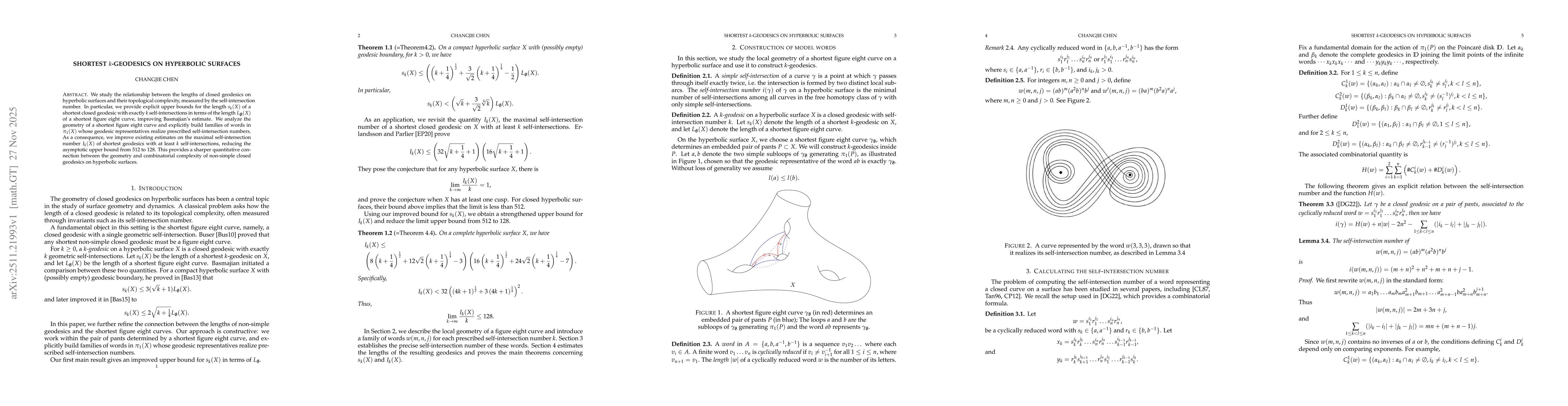
We study the relationship between the lengths of closed geodesics on hyperbolic surfaces and their topological complexity, measured by the self-intersection number. In particular, we provide explicit ...

Thumbnail for Enhancing Demand-Oriented Regionalization with Agentic AI and Local Heterogeneous Data for Adaptation Planning

Enhancing Demand-Oriented Regionalization with Agentic AI and Local Heterogeneous Data for Adaptation Planning

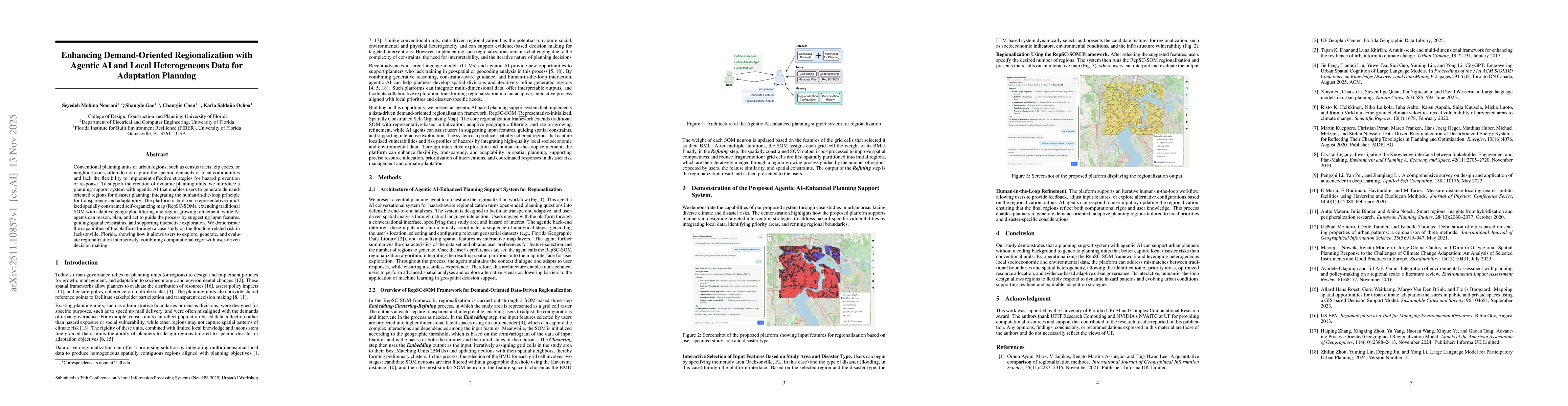
Conventional planning units or urban regions, such as census tracts, zip codes, or neighborhoods, often do not capture the specific demands of local communities and lack the flexibility to implement e...

Thumbnail for From Sparse to Dense: Spatio-Temporal Fusion for Multi-View 3D Human Pose Estimation with DenseWarper

From Sparse to Dense: Spatio-Temporal Fusion for Multi-View 3D Human Pose Estimation with DenseWarper

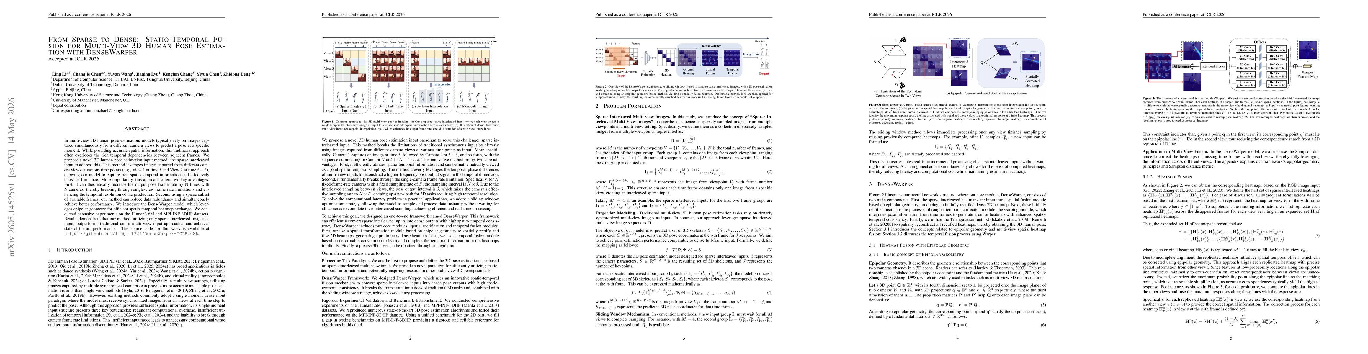
In multi-view 3D human pose estimation, models typically rely on images captured simultaneously from different camera views to predict a pose at a specific moment. While providing accurate spatial inf...

This website uses cookies to ensure you get the best experience. Learn more