ArxivLens
C
Researcher

Craig A. Knoblock

University of Southern California, Information Sciences Institute

6 arXiv Papers
446 Total Publications
Profile

Academic Profile

Name Craig A. Knoblock
Affiliations University of Southern California, Information Sciences Institute
Total Papers 446
Homepage Visit Homepage
Scholar Profile View on Semantic Scholar
Metrics

Statistics

6 arXiv Papers
446 Total Publications
Publications

Papers on arXiv

Thumbnail for Towards the automated large-scale reconstruction of past road networks
  from historical maps
arXiv
Towards the automated large-scale reconstruction of past road networks from historical maps

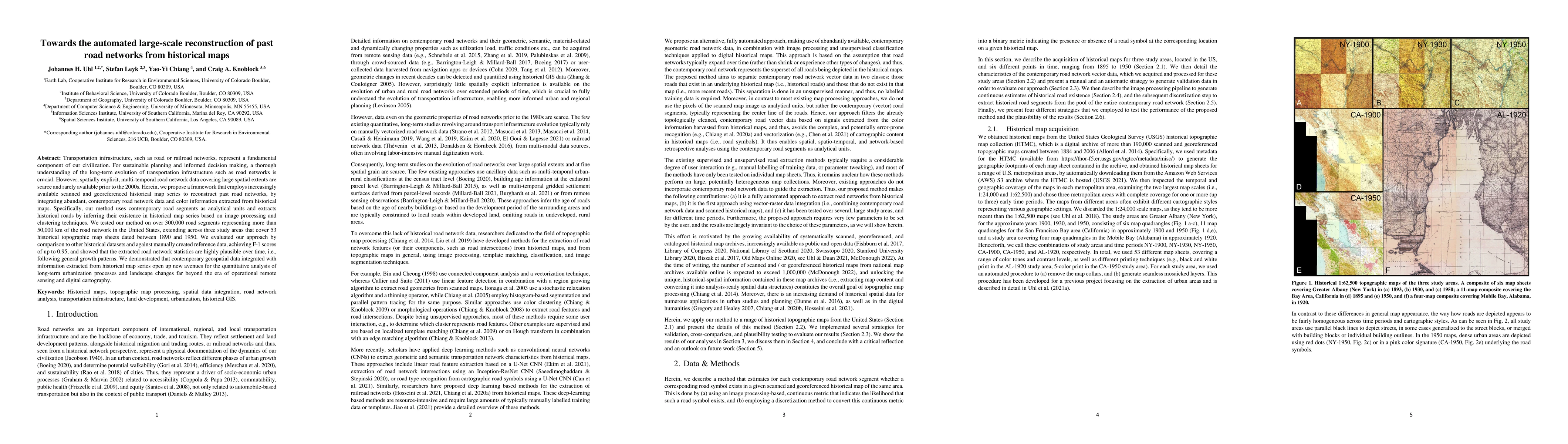
Transportation infrastructure, such as road or railroad networks, represent a fundamental component of our civilization. For sustainable planning and informed decision making, a thorough understandi...

Thumbnail for Synthetic Map Generation to Provide Unlimited Training Data for
  Historical Map Text Detection
arXiv
Synthetic Map Generation to Provide Unlimited Training Data for Historical Map Text Detection

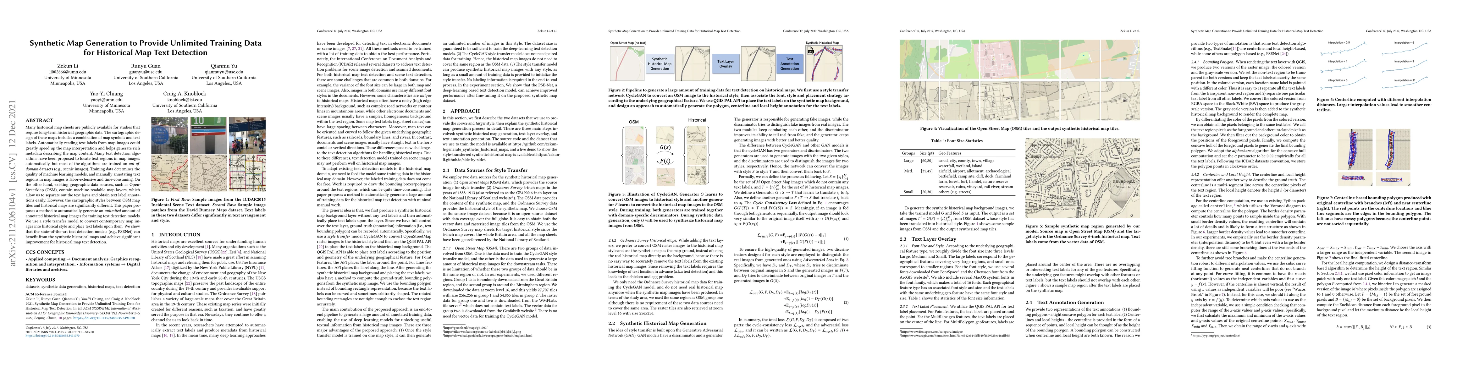
Many historical map sheets are publicly available for studies that require long-term historical geographic data. The cartographic design of these maps includes a combination of map symbols and text ...

Thumbnail for A Label Correction Algorithm Using Prior Information for Automatic and
  Accurate Geospatial Object Recognition
arXiv
A Label Correction Algorithm Using Prior Information for Automatic and Accurate Geospatial Object Recognition

Thousands of scanned historical topographic maps contain valuable information covering long periods of time, such as how the hydrography of a region has changed over time. Efficiently unlocking the ...

Thumbnail for Guided Generative Models using Weak Supervision for Detecting Object
  Spatial Arrangement in Overhead Images
arXiv
Guided Generative Models using Weak Supervision for Detecting Object Spatial Arrangement in Overhead Images

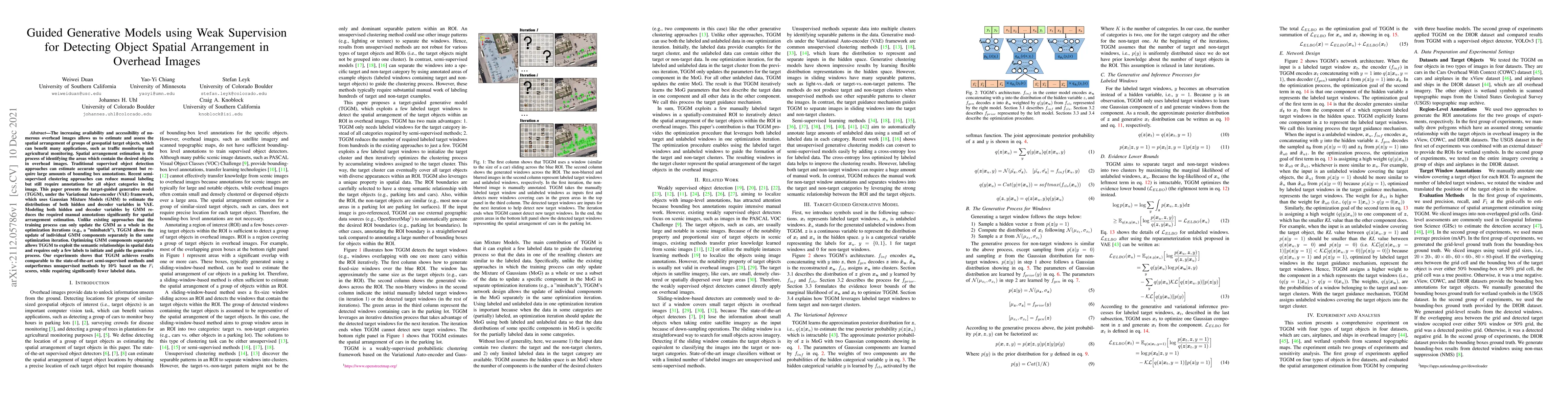
The increasing availability and accessibility of numerous overhead images allows us to estimate and assess the spatial arrangement of groups of geospatial target objects, which can benefit many appl...

Thumbnail for An Automatic Approach for Generating Rich, Linked Geo-Metadata from
  Historical Map Images
arXiv
An Automatic Approach for Generating Rich, Linked Geo-Metadata from Historical Map Images

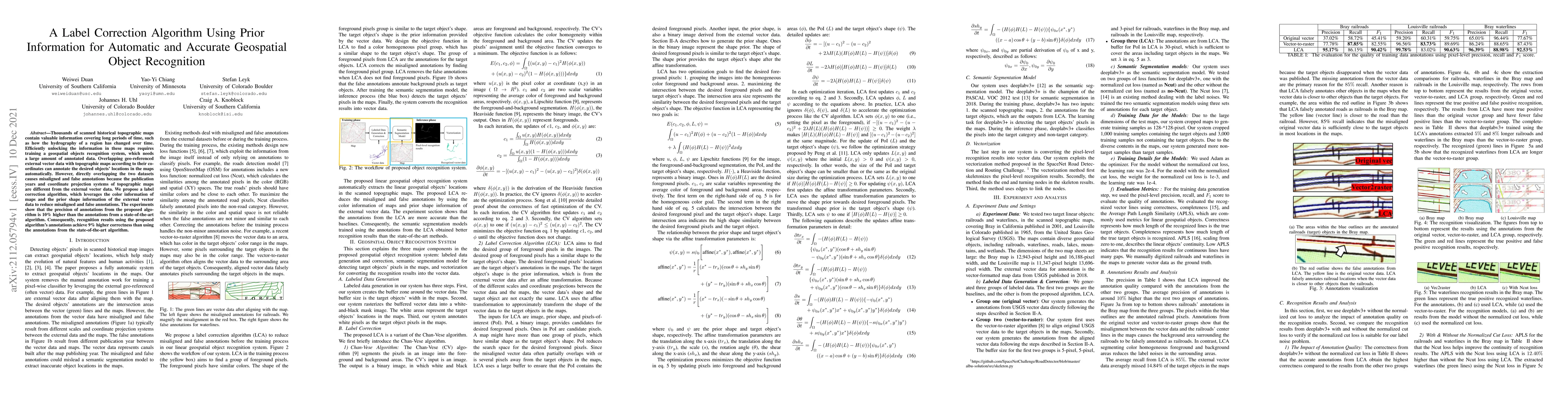
Historical maps contain detailed geographic information difficult to find elsewhere covering long-periods of time (e.g., 125 years for the historical topographic maps in the US). However, these maps...

Thumbnail for DIGMAPPER: A Modular System for Automated Geologic Map Digitization
arXiv
DIGMAPPER: A Modular System for Automated Geologic Map Digitization

Historical geologic maps contain rich geospatial information, such as rock units, faults, folds, and bedding planes, that is critical for assessing mineral resources essential to renewable energy, ele...

This website uses cookies to ensure you get the best experience. Learn more