Academic Profile
Statistics
Similar Authors
Papers on arXiv
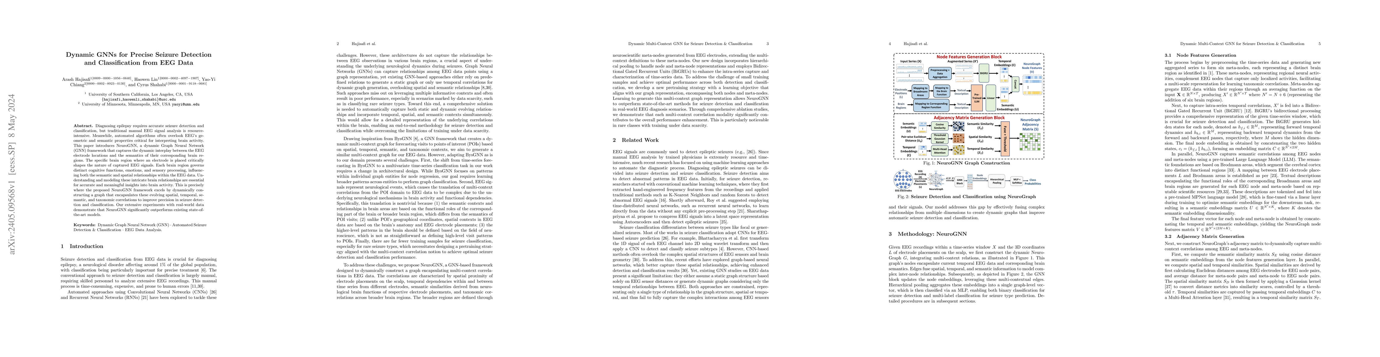
Diagnosing epilepsy requires accurate seizure detection and classification, but traditional manual EEG signal analysis is resource-intensive. Meanwhile, automated algorithms often overlook EEG's geo...
Despite location being increasingly used in decision-making systems employed in many sensitive domains such as mortgages and insurance, astonishingly little attention has been paid to unfairness tha...
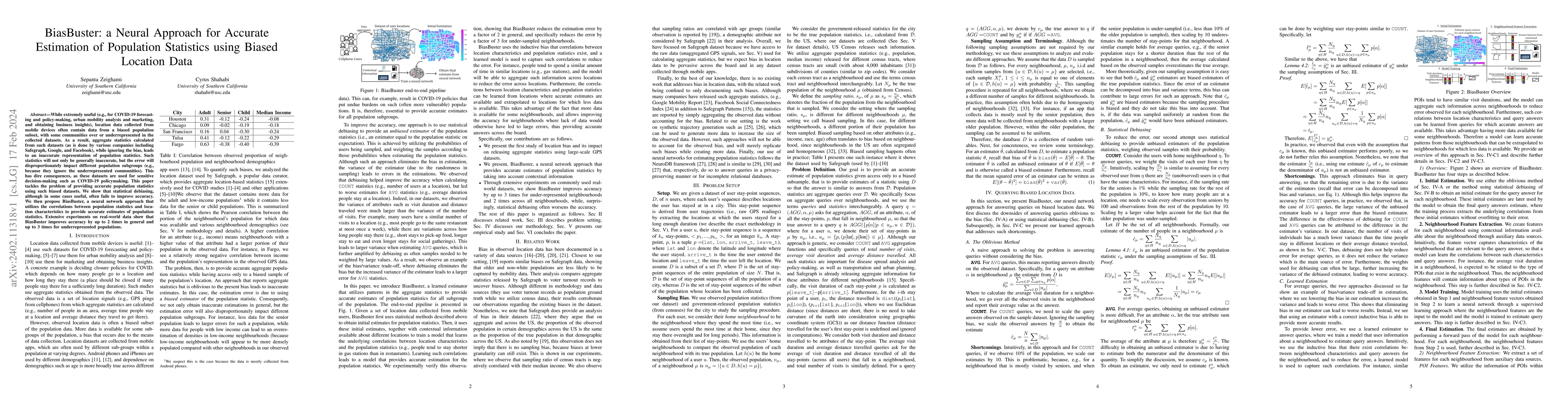
While extremely useful (e.g., for COVID-19 forecasting and policy-making, urban mobility analysis and marketing, and obtaining business insights), location data collected from mobile devices often c...
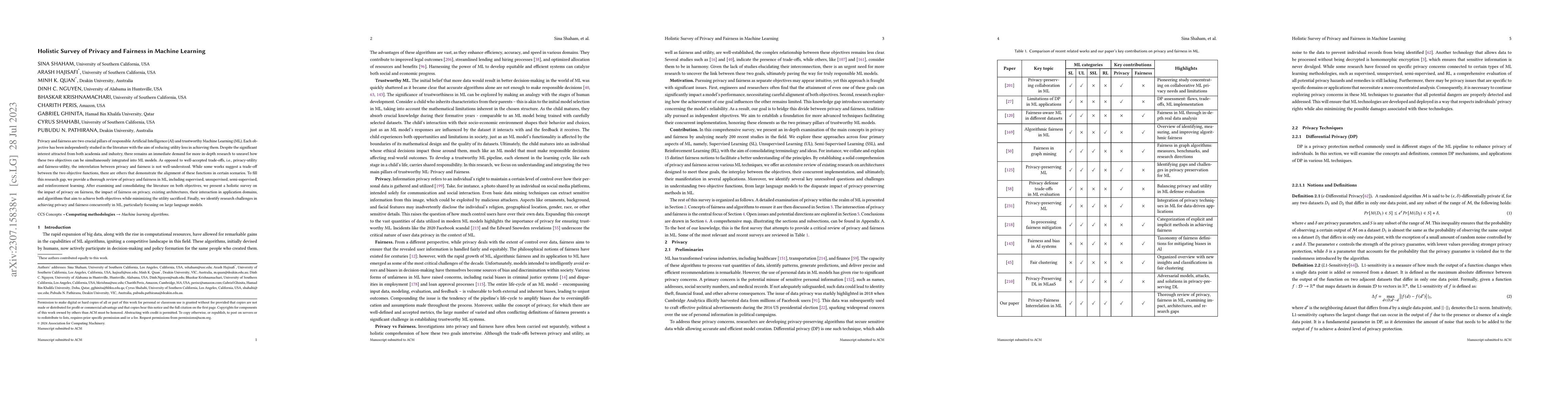
Privacy and fairness are two crucial pillars of responsible Artificial Intelligence (AI) and trustworthy Machine Learning (ML). Each objective has been independently studied in the literature with t...
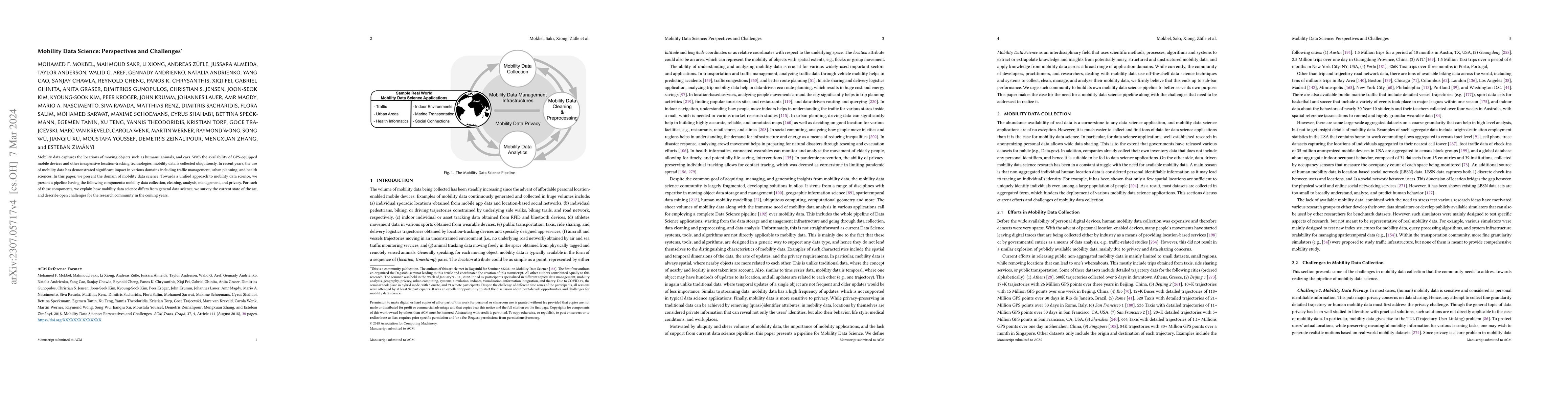
Mobility data captures the locations of moving objects such as humans, animals, and cars. With the availability of GPS-equipped mobile devices and other inexpensive location-tracking technologies, m...
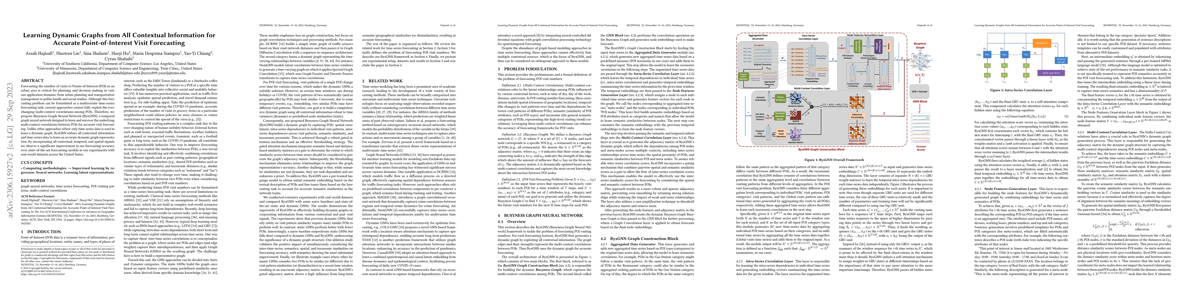
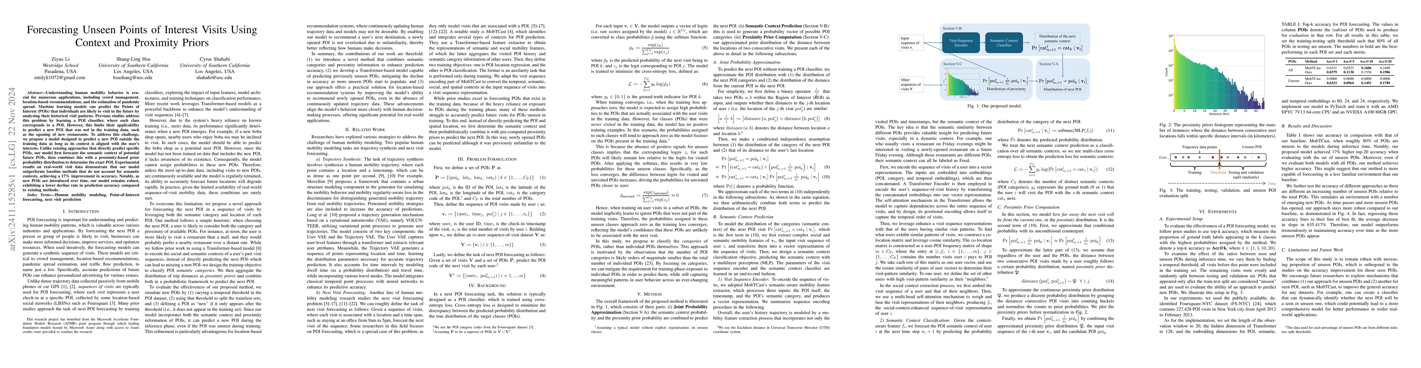
Forecasting the number of visits to Points-of-Interest (POI) in an urban area is critical for planning and decision-making for various application domains, from urban planning and transportation man...
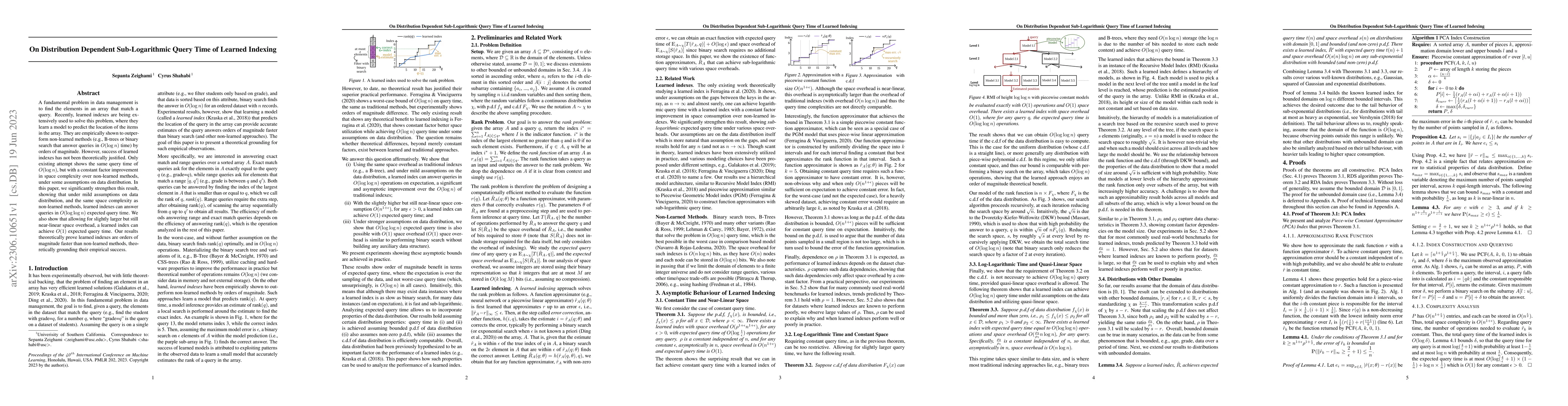
A fundamental problem in data management is to find the elements in an array that match a query. Recently, learned indexes are being extensively used to solve this problem, where they learn a model ...
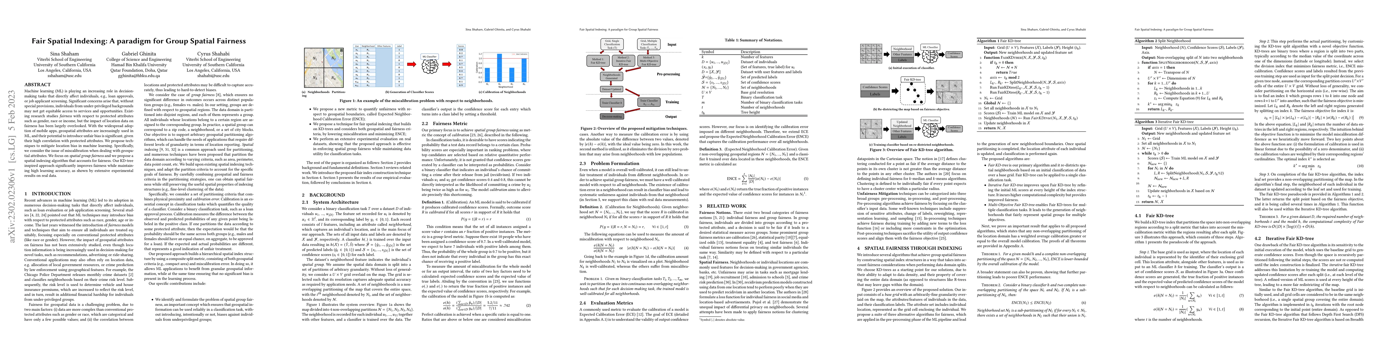
Machine learning (ML) is playing an increasing role in decision-making tasks that directly affect individuals, e.g., loan approvals, or job applicant screening. Significant concerns arise that, with...
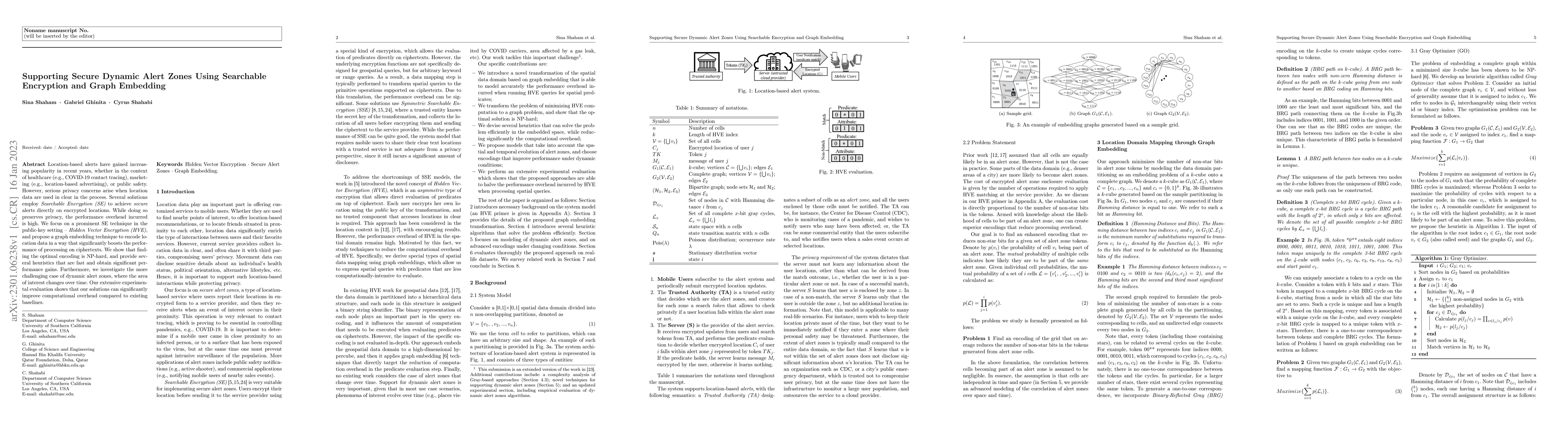
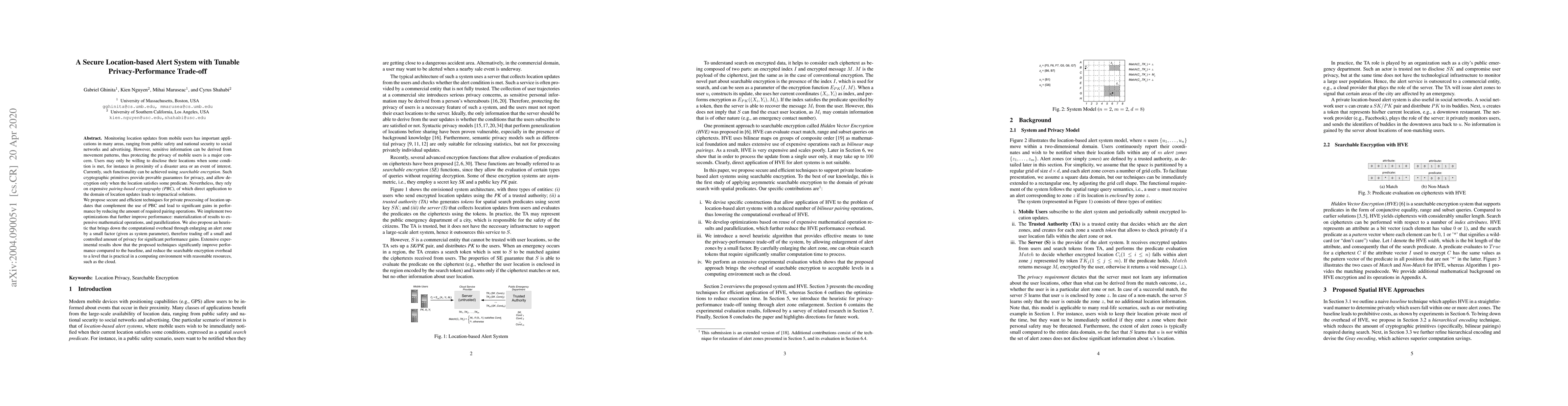
Location-based alerts have gained increasing popularity in recent years, whether in the context of healthcare (e.g., COVID-19 contact tracing), marketing (e.g., location-based advertising), or publi...
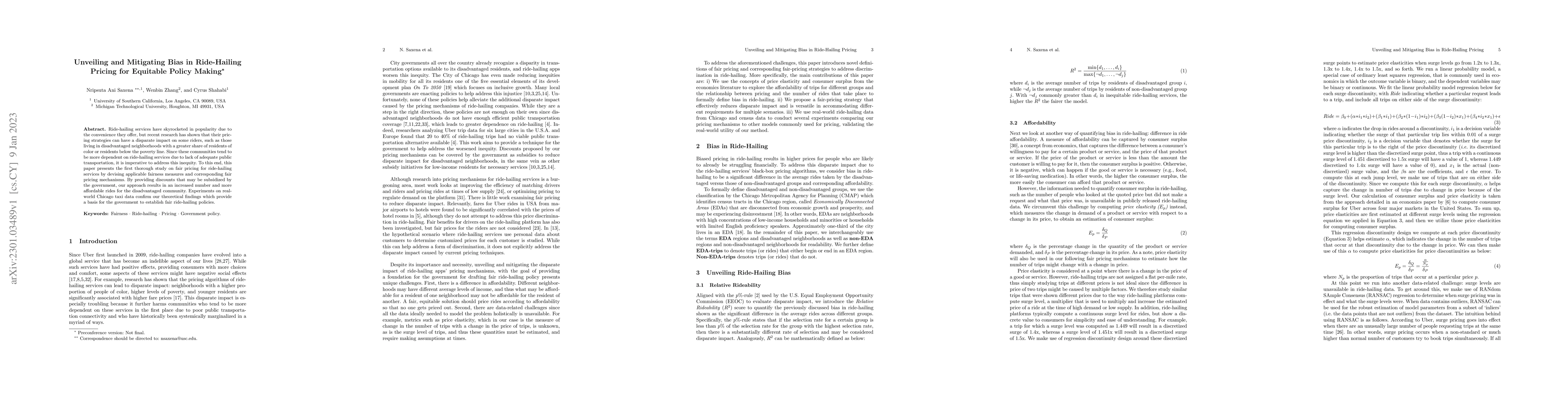
Ride-hailing services have skyrocketed in popularity due to the convenience they offer, but recent research has shown that their pricing strategies can have a disparate impact on some riders, such a...
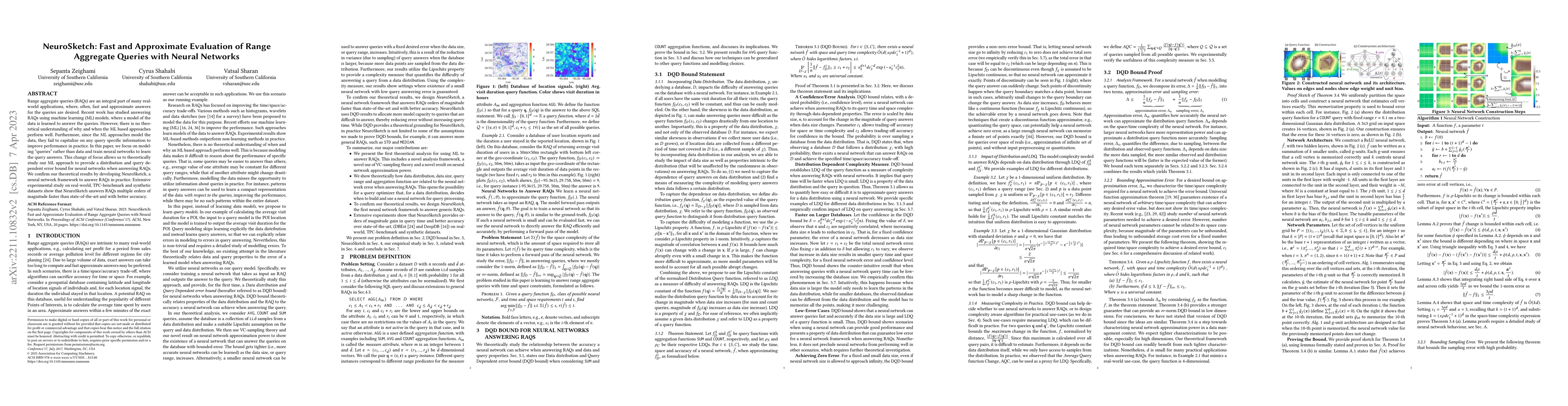
Range aggregate queries (RAQs) are an integral part of many real-world applications, where, often, fast and approximate answers for the queries are desired. Recent work has studied answering RAQs us...
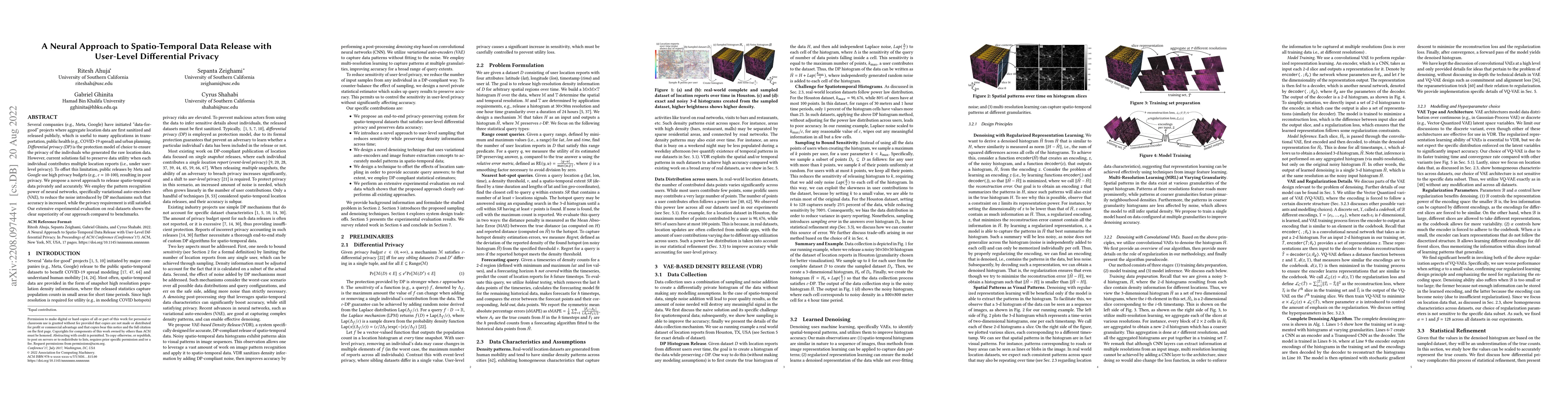
Several companies (e.g., Meta, Google) have initiated "data-for-good" projects where aggregate location data are first sanitized and released publicly, which is useful to many applications in transp...
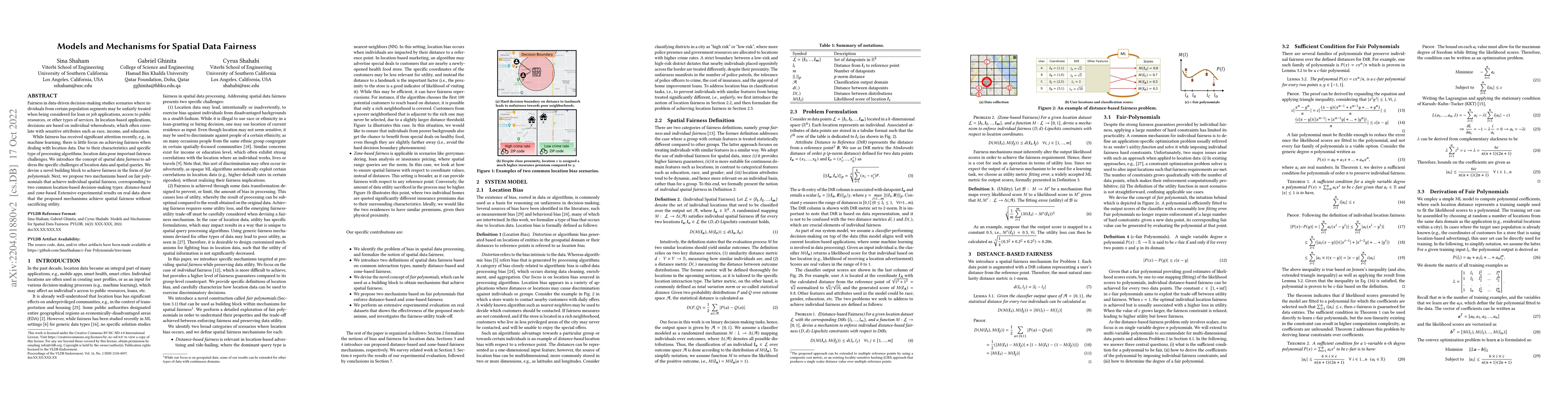
Fairness in data-driven decision-making studies scenarios where individuals from certain population segments may be unfairly treated when being considered for loan or job applications, access to pub...
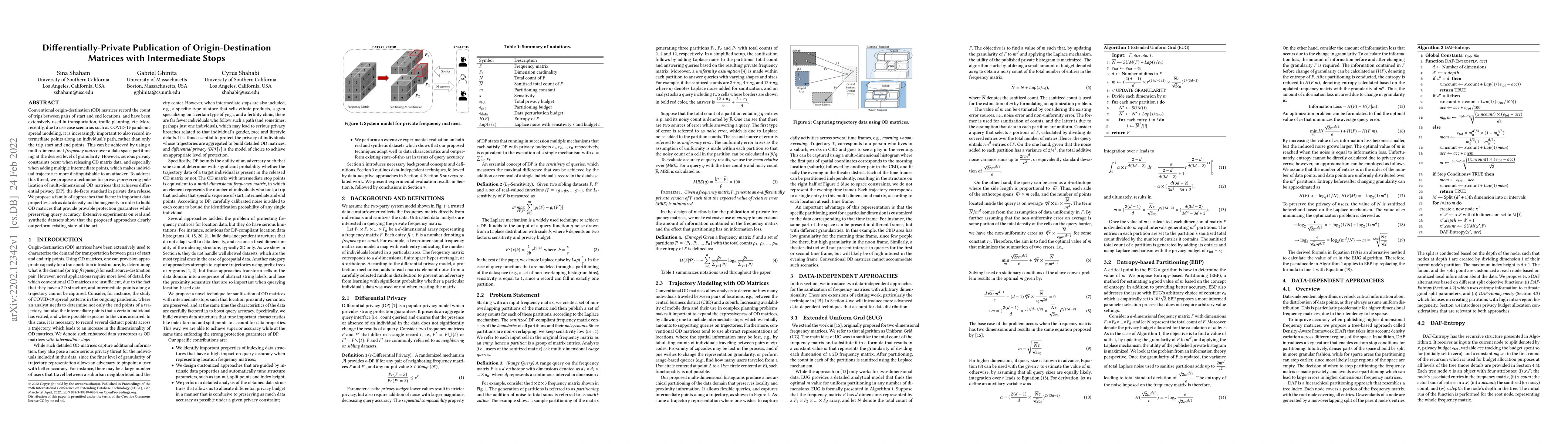
Conventional origin-destination (OD) matrices record the count of trips between pairs of start and end locations, and have been extensively used in transportation, traffic planning, etc. More recent...
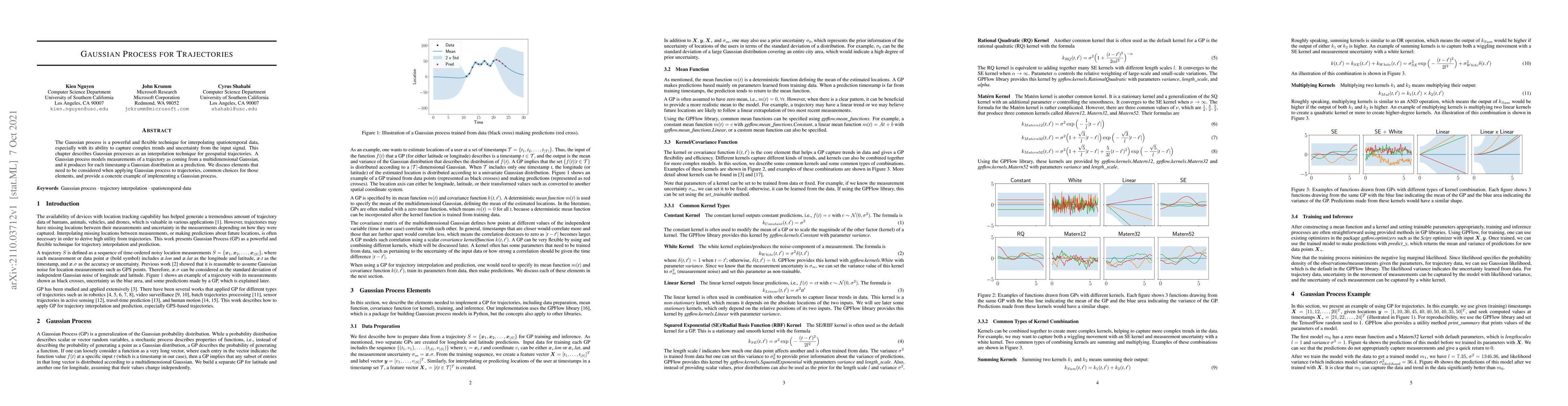
The Gaussian process is a powerful and flexible technique for interpolating spatiotemporal data, especially with its ability to capture complex trends and uncertainty from the input signal. This cha...
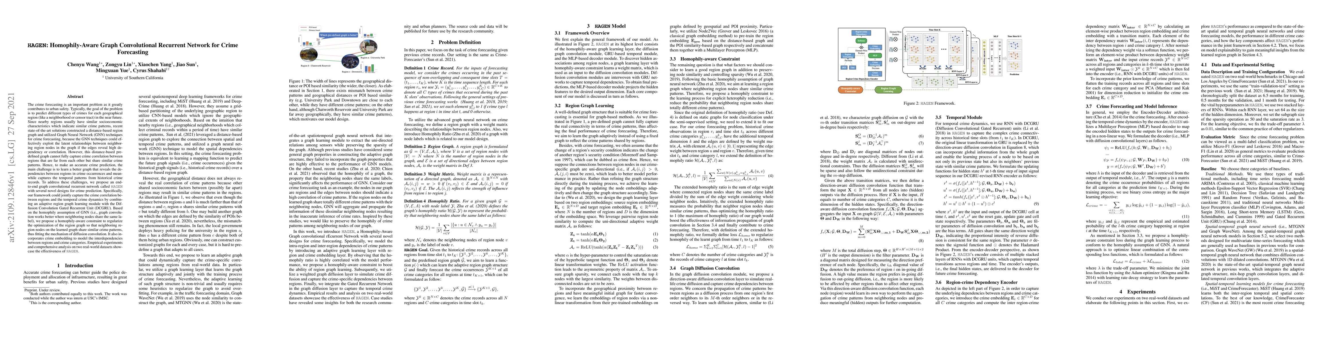
The crime forecasting is an important problem as it greatly contributes to urban safety. Typically, the goal of the problem is to predict different types of crimes for each geographical region (like...
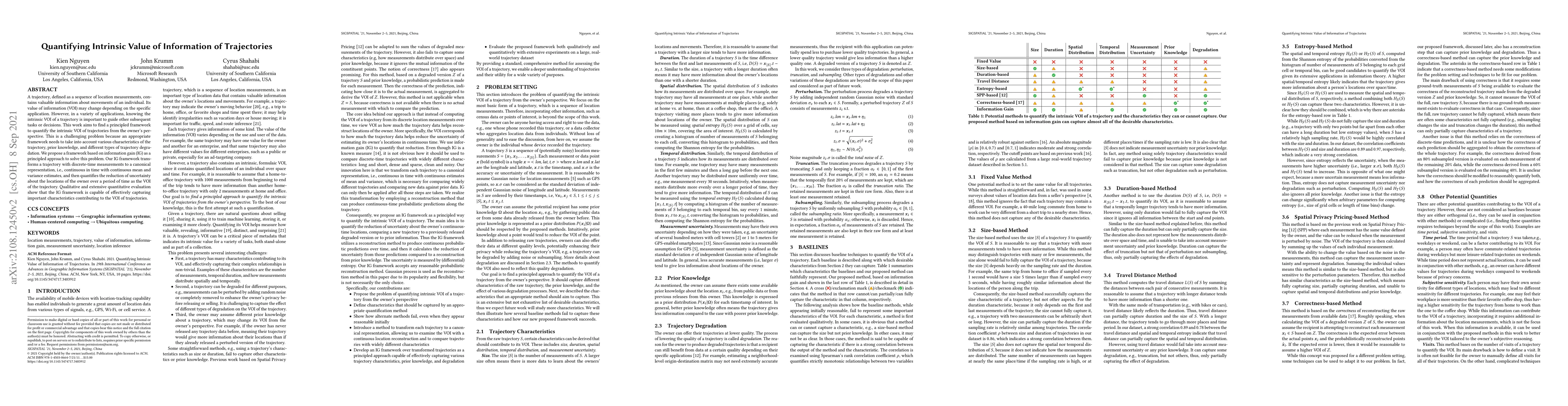
A trajectory, defined as a sequence of location measurements, contains valuable information about movements of an individual. Its value of information (VOI) may change depending on the specific appl...
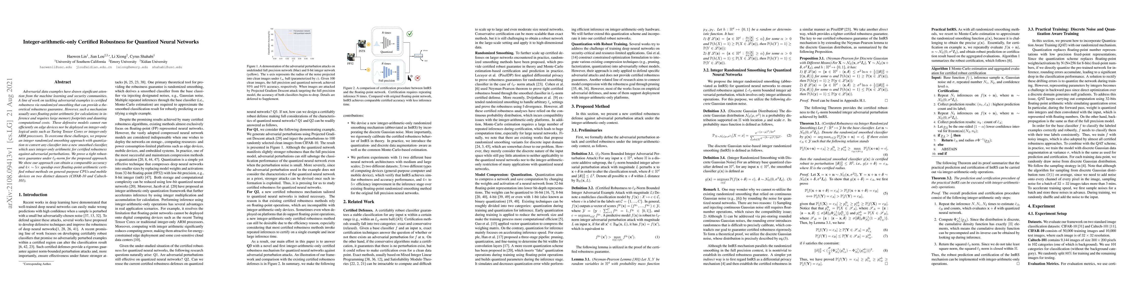
Adversarial data examples have drawn significant attention from the machine learning and security communities. A line of work on tackling adversarial examples is certified robustness via randomized ...
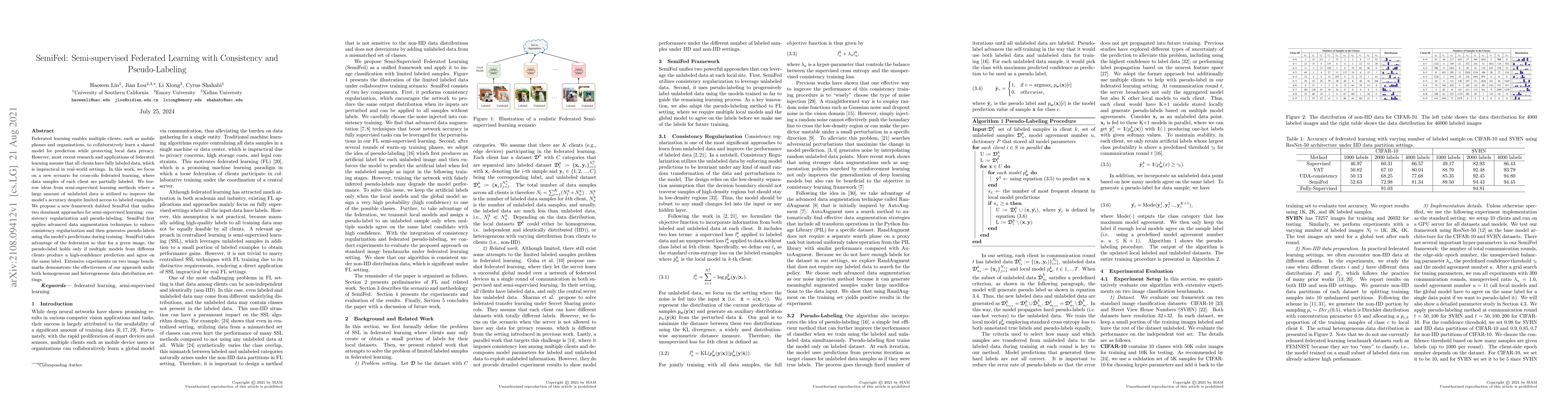
Federated learning enables multiple clients, such as mobile phones and organizations, to collaboratively learn a shared model for prediction while protecting local data privacy. However, most recent...
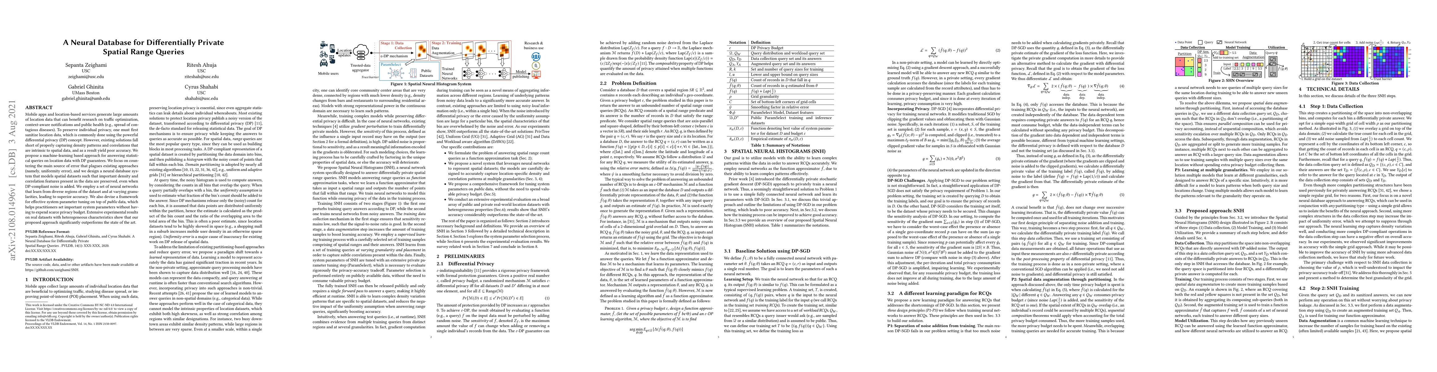
Mobile apps and location-based services generate large amounts of location data that can benefit research on traffic optimization, context-aware notifications and public health (e.g., spread of cont...
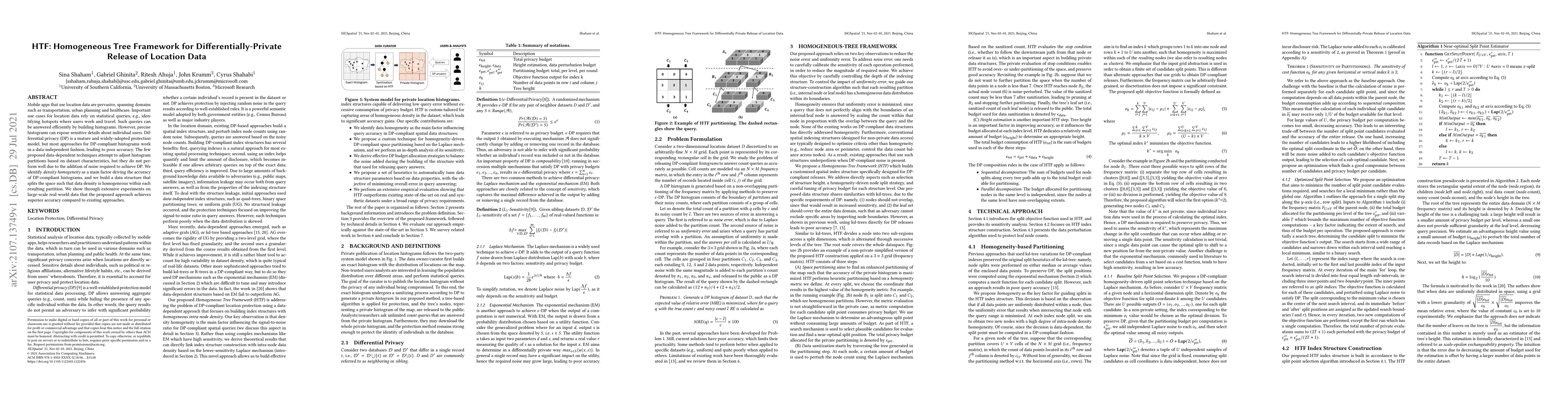
Mobile apps that use location data are pervasive, spanning domains such as transportation, urban planning and healthcare. Important use cases for location data rely on statistical queries, e.g., ide...
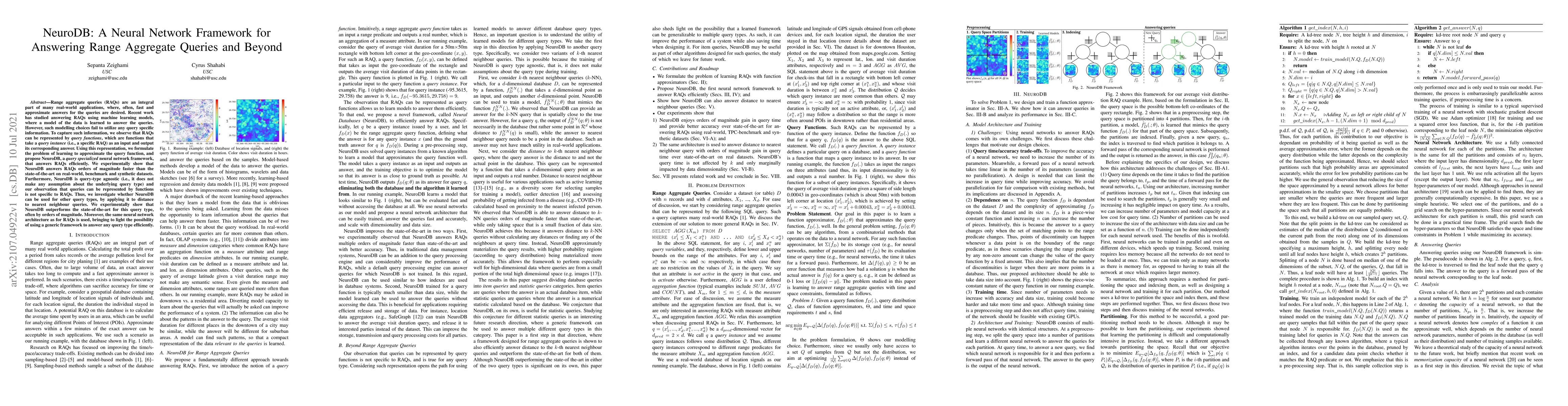
Range aggregate queries (RAQs) are an integral part of many real-world applications, where, often, fast and approximate answers for the queries are desired. Recent work has studied answering RAQs us...
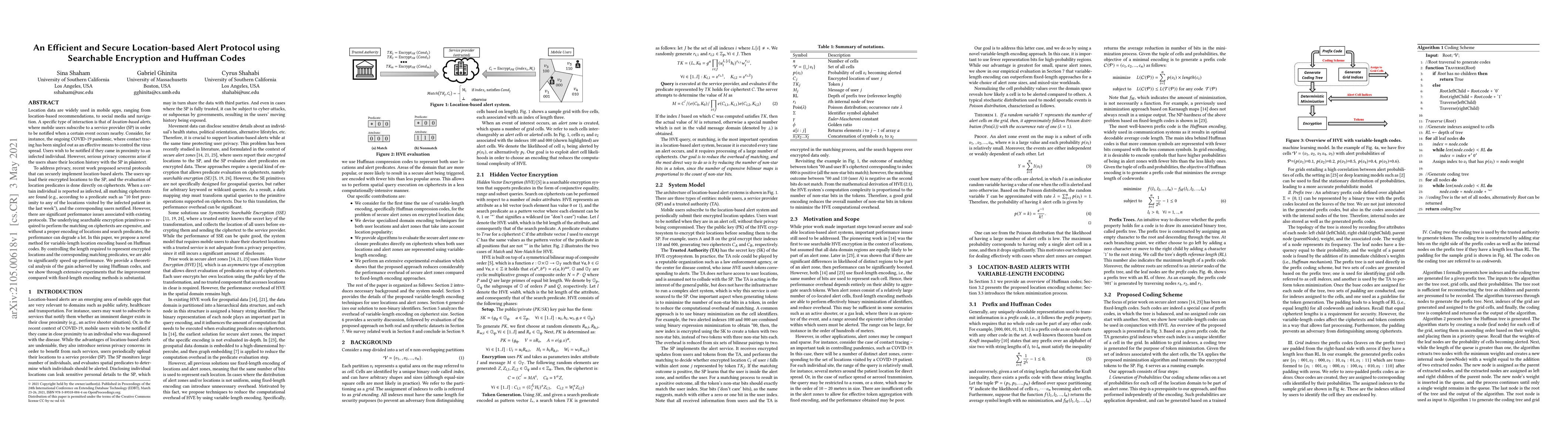
Location data are widely used in mobile apps, ranging from location-based recommendations, to social media and navigation. A specific type of interaction is that of location-based alerts, where mobi...
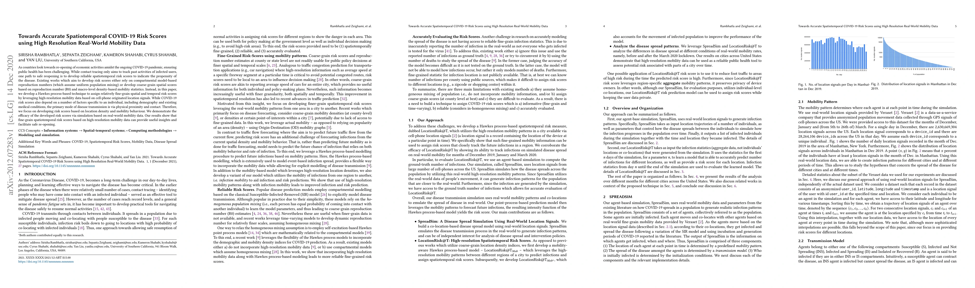
As countries look towards re-opening of economic activities amidst the ongoing COVID-19 pandemic, ensuring public health has been challenging. While contact tracing only aims to track past activitie...
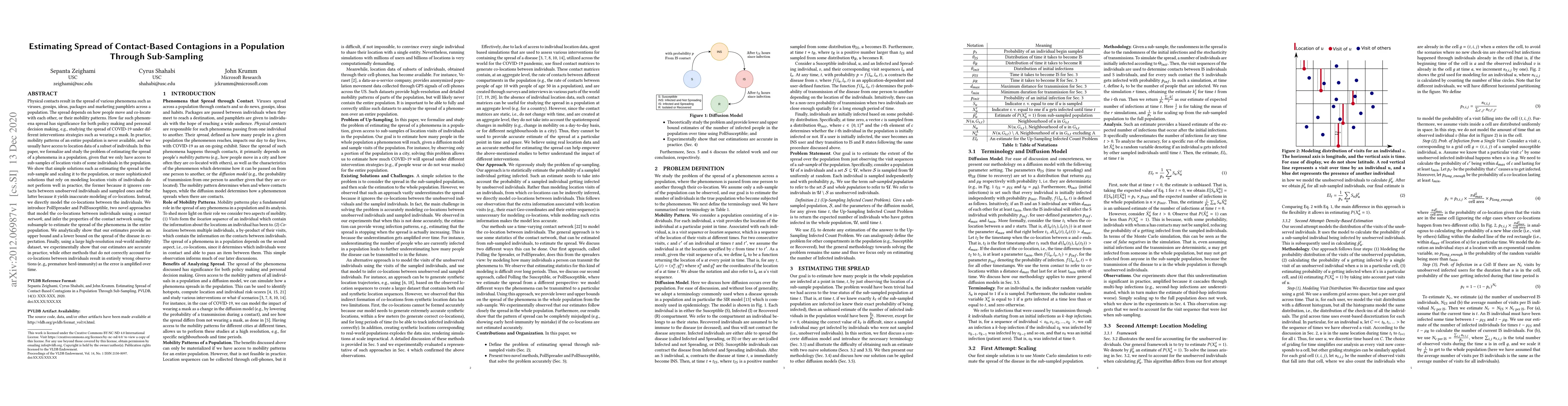
Physical contacts result in the spread of various phenomena such as viruses, gossips, ideas, packages and marketing pamphlets across a population. The spread depends on how people move and co-locate...
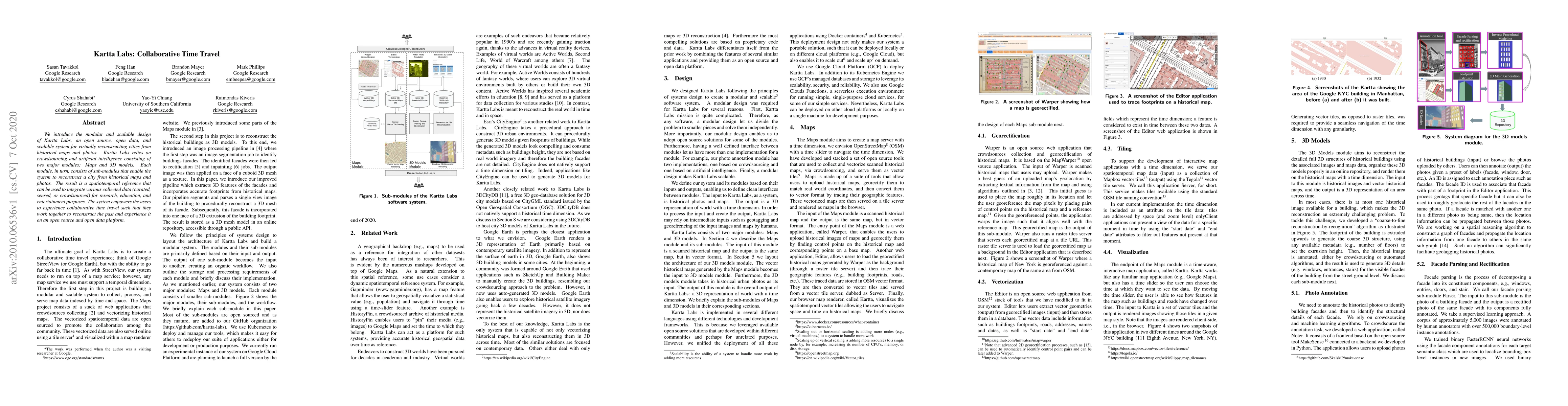
We introduce the modular and scalable design of Kartta Labs, an open source, open data, and scalable system for virtually reconstructing cities from historical maps and photos. Kartta Labs relies on...
Monitoring location updates from mobile users has important applications in many areas, ranging from public safety and national security to social networks and advertising. However, sensitive inform...
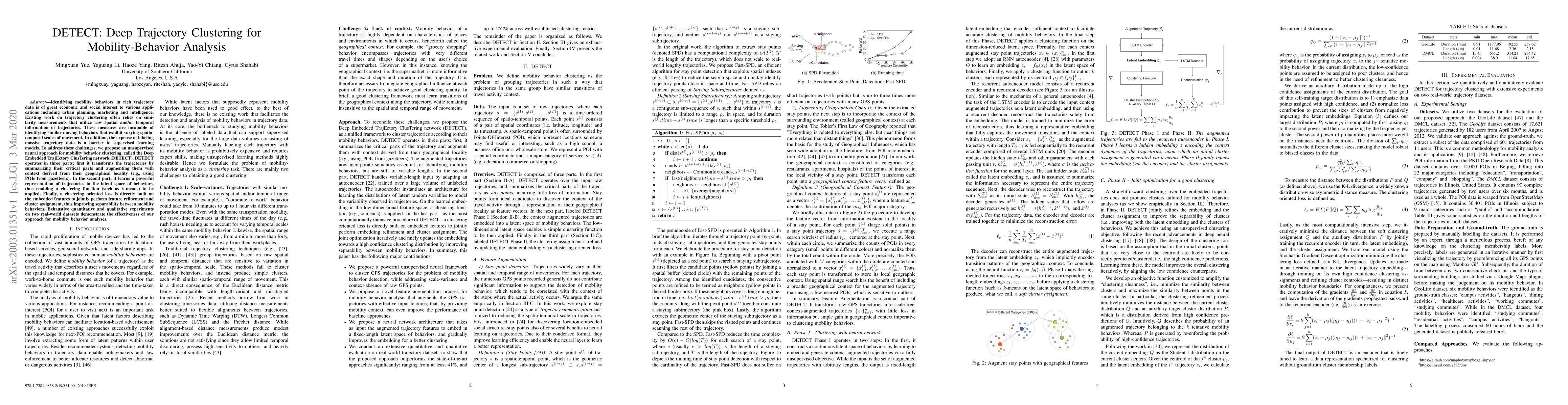
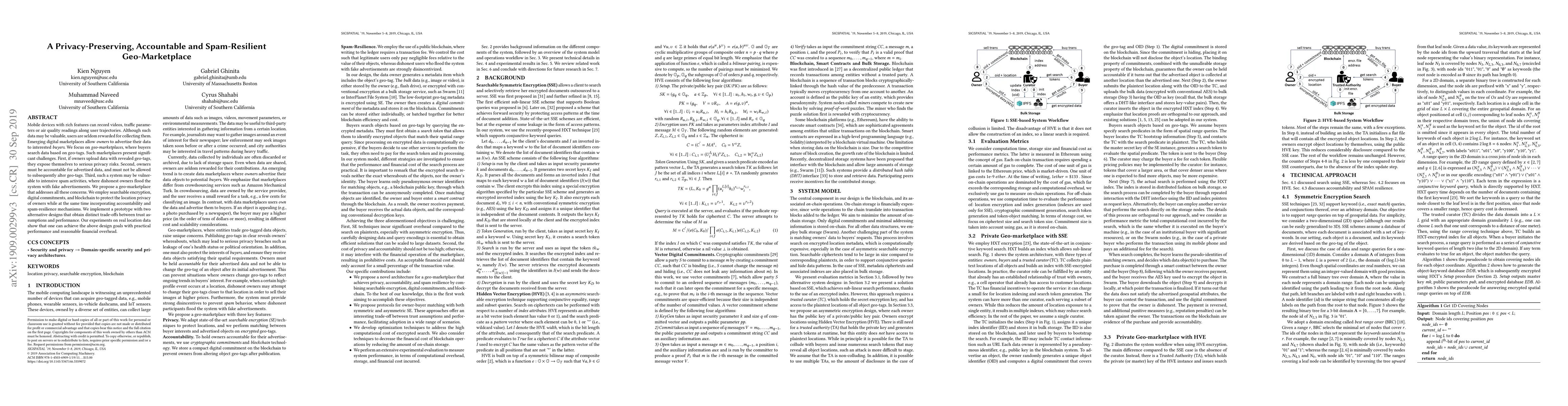
Identifying mobility behaviors in rich trajectory data is of great economic and social interest to various applications including urban planning, marketing and intelligence. Existing work on traject...
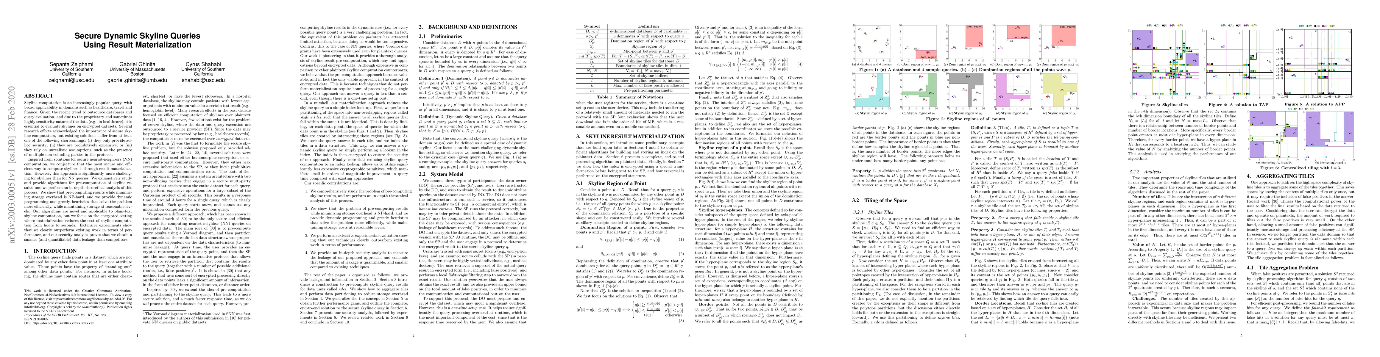
Skyline computation is an increasingly popular query, with broad applicability in domains such as healthcare, travel and finance. Given the recent trend to outsource databases and query evaluation, ...
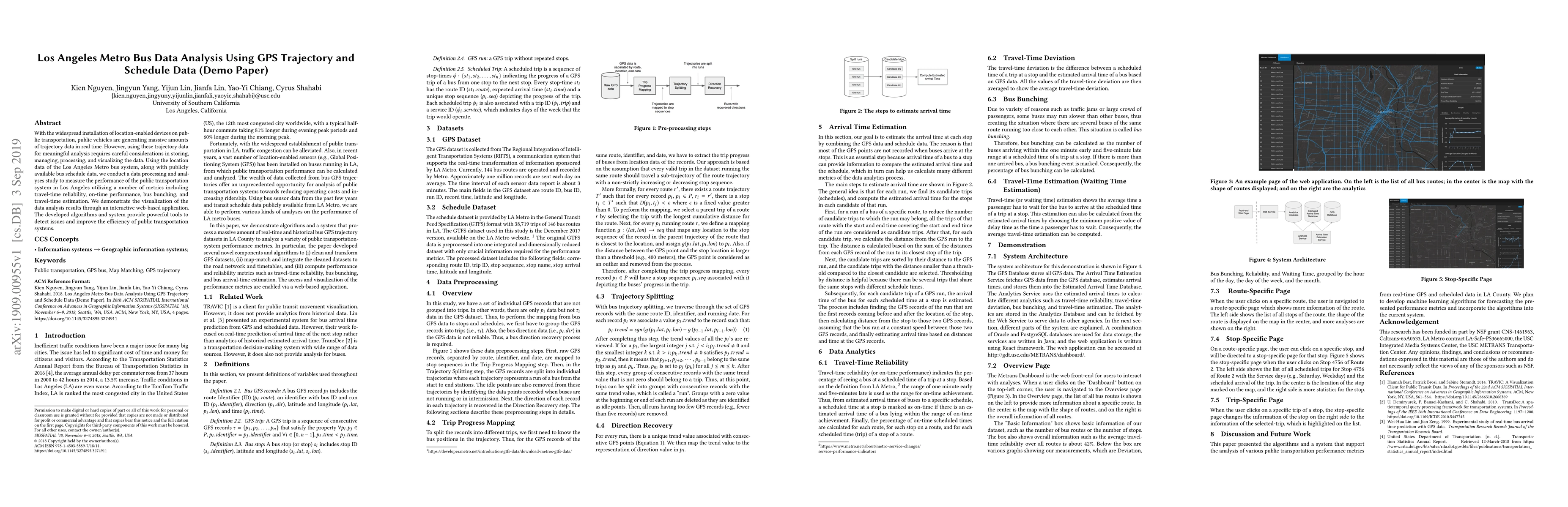
With the widespread installation of location-enabled devices on public transportation, public vehicles are generating massive amounts of trajectory data in real time. However, using these trajectory...
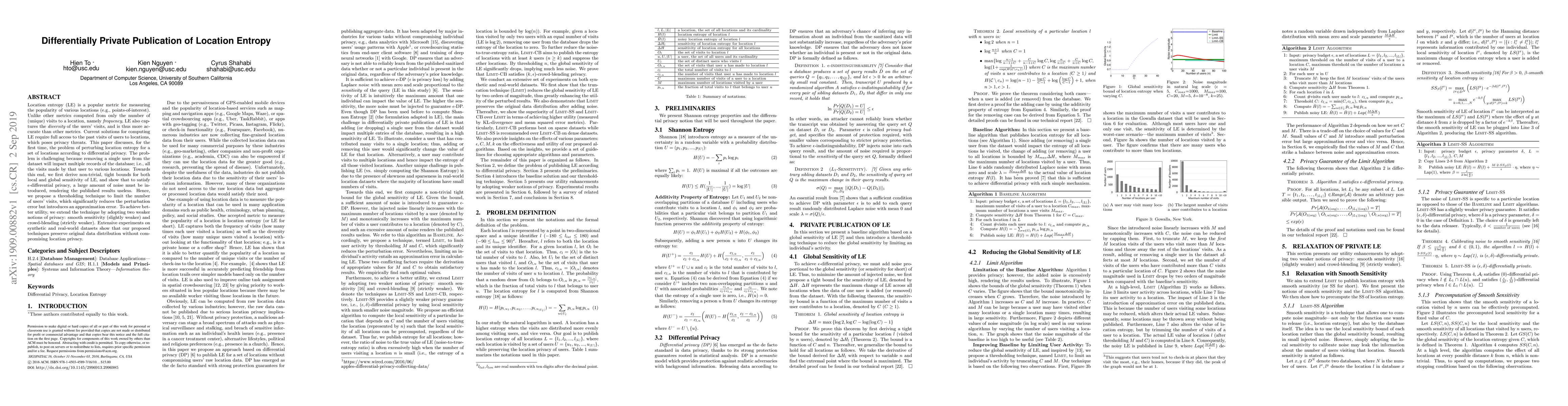
Location entropy (LE) is a popular metric for measuring the popularity of various locations (e.g., points-of-interest). Unlike other metrics computed from only the number of (unique) visits to a loc...
Mobile devices with rich features can record videos, traffic parameters or air quality readings along user trajectories. Although such data may be valuable, users are seldom rewarded for collecting ...
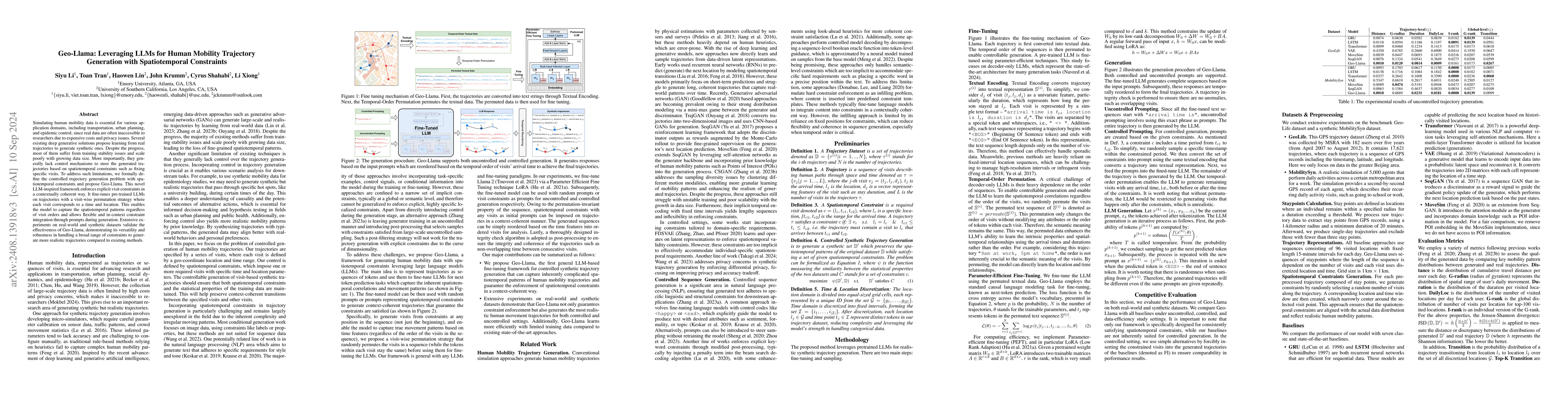
Simulating human mobility data is essential for various application domains, including transportation, urban planning, and epidemic control, since real data are often inaccessible to researchers due t...
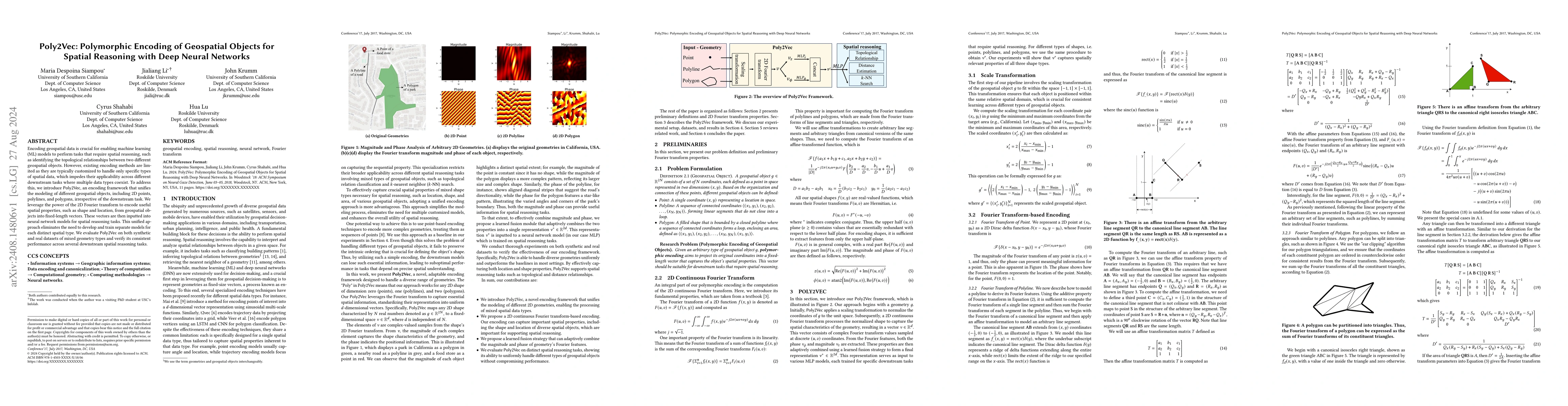
Encoding geospatial data is crucial for enabling machine learning (ML) models to perform tasks that require spatial reasoning, such as identifying the topological relationships between two different g...
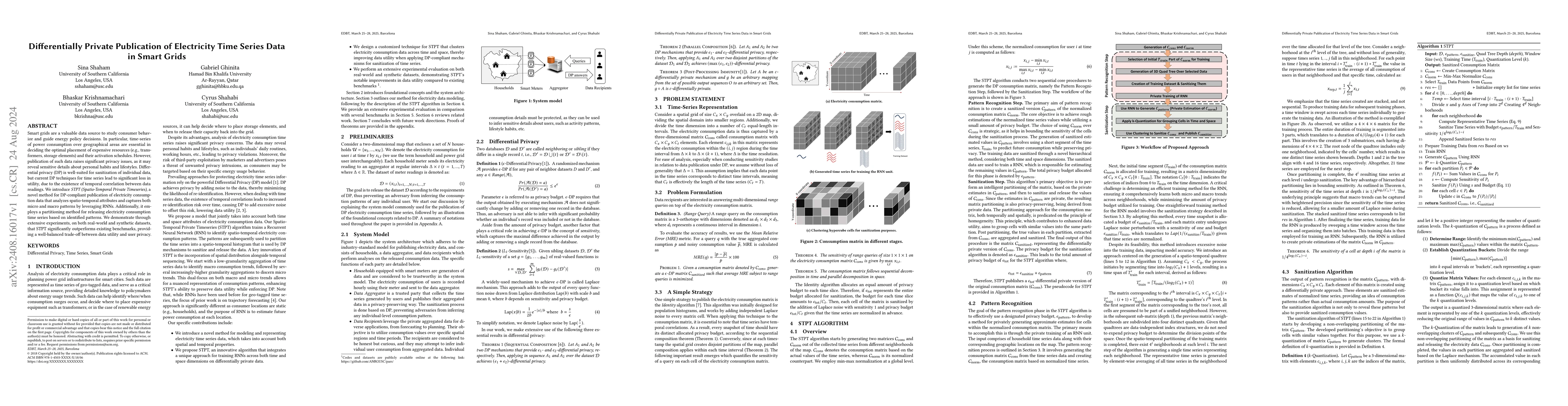
Smart grids are a valuable data source to study consumer behavior and guide energy policy decisions. In particular, time-series of power consumption over geographical areas are essential in deciding t...
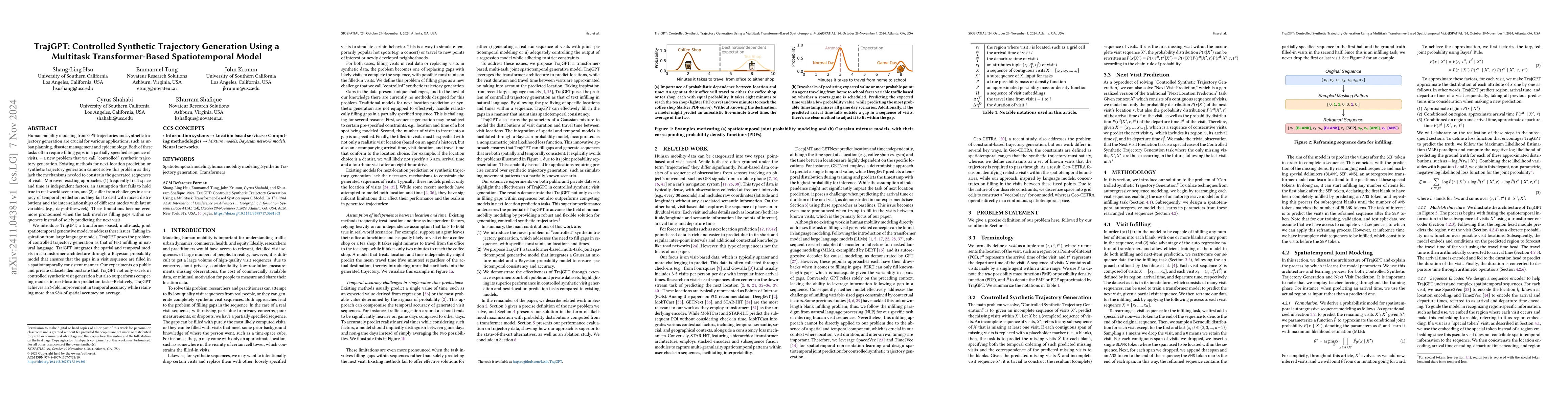
Human mobility modeling from GPS-trajectories and synthetic trajectory generation are crucial for various applications, such as urban planning, disaster management and epidemiology. Both of these task...
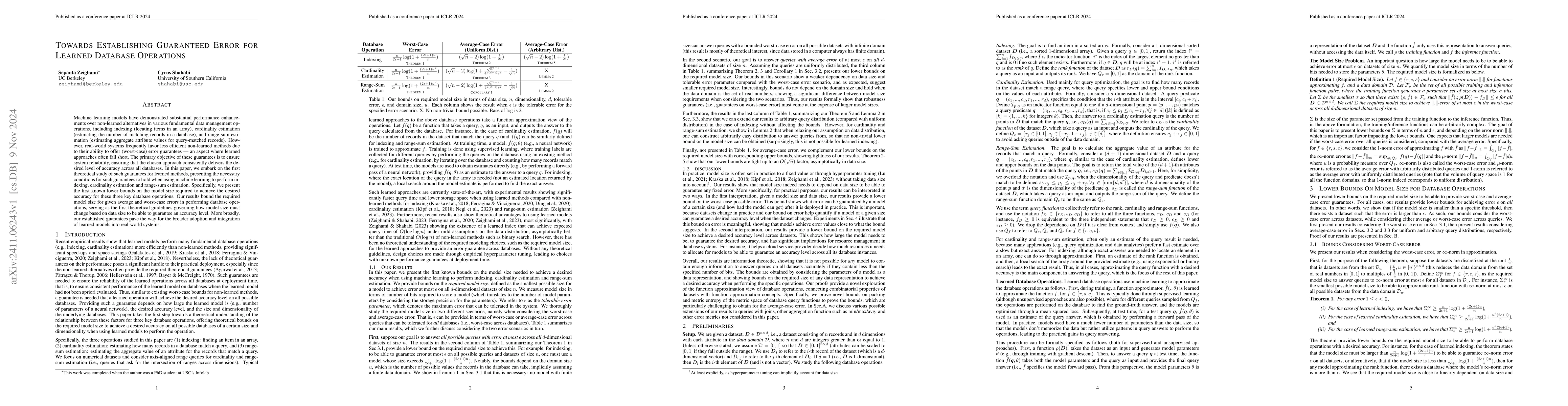
Machine learning models have demonstrated substantial performance enhancements over non-learned alternatives in various fundamental data management operations, including indexing (locating items in an...
Understanding human mobility behavior is crucial for numerous applications, including crowd management, location-based recommendations, and the estimation of pandemic spread. Machine learning models c...
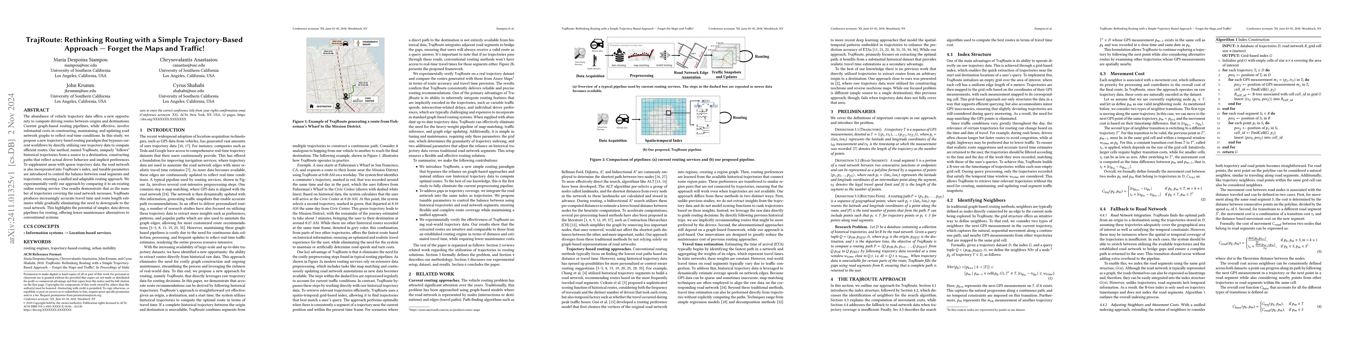
The abundance of vehicle trajectory data offers a new opportunity to compute driving routes between origins and destinations. Current graph-based routing pipelines, while effective, involve substantia...
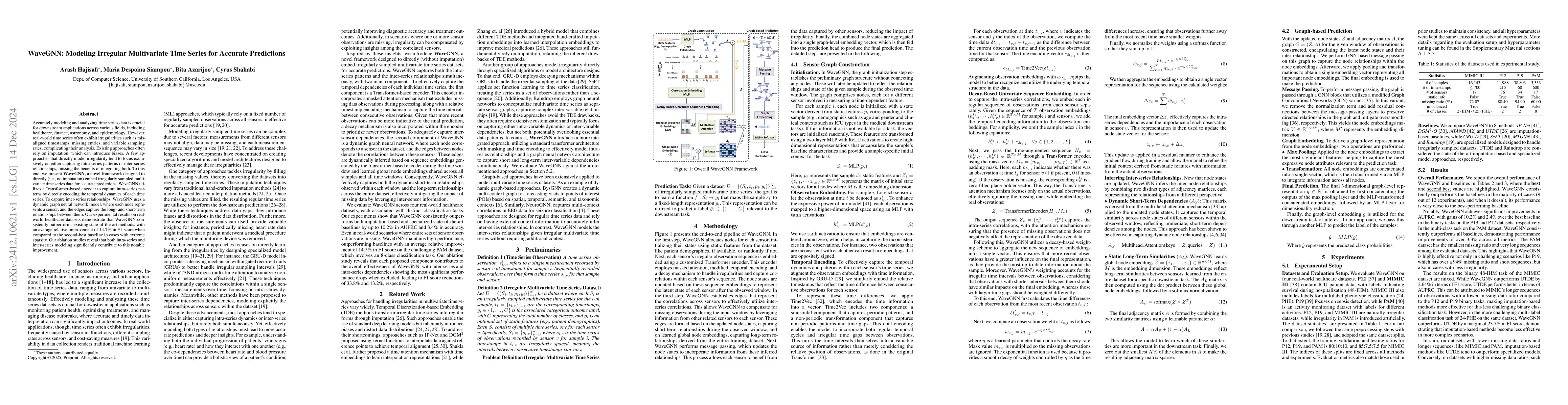
Accurately modeling and analyzing time series data is crucial for downstream applications across various fields, including healthcare, finance, astronomy, and epidemiology. However, real-world time se...
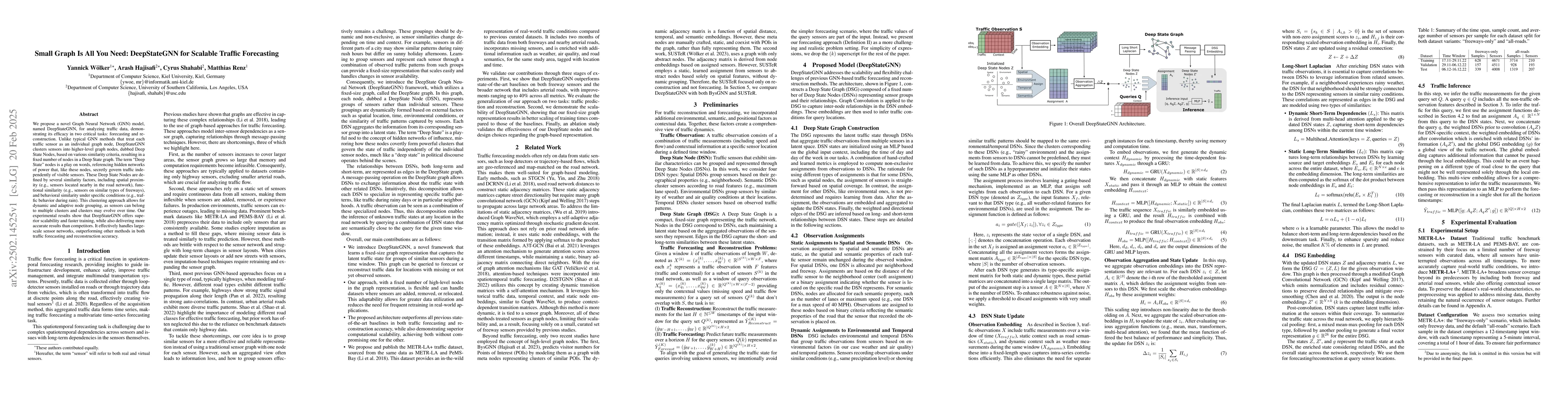
We propose a novel Graph Neural Network (GNN) model, named DeepStateGNN, for analyzing traffic data, demonstrating its efficacy in two critical tasks: forecasting and reconstruction. Unlike typical GN...
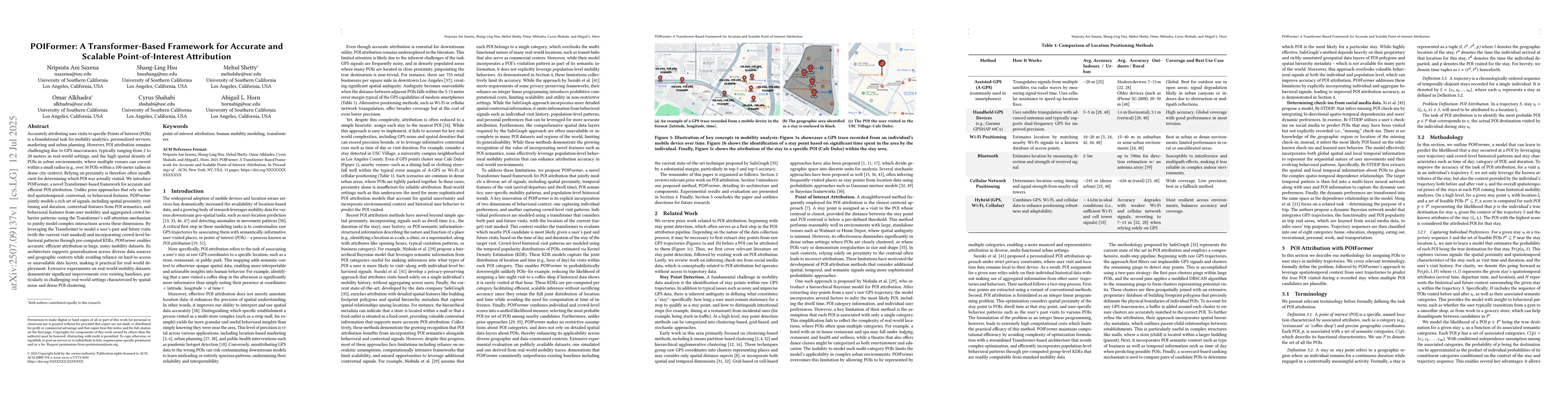
Accurately attributing user visits to specific Points of Interest (POIs) is a foundational task for mobility analytics, personalized services, marketing and urban planning. However, POI attribution re...
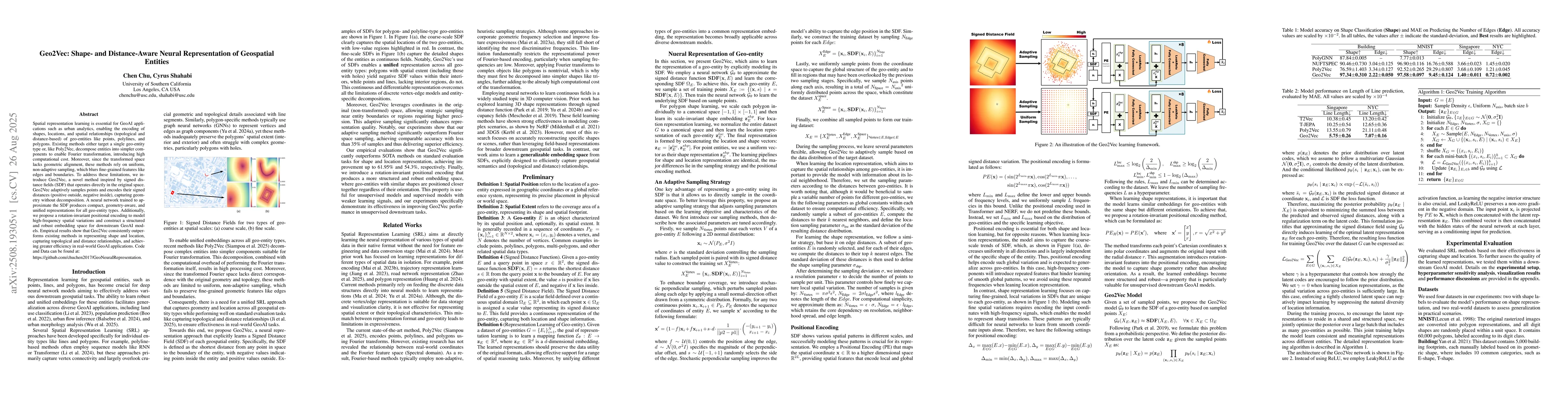
Spatial representation learning is essential for GeoAI applications such as urban analytics, enabling the encoding of shapes, locations, and spatial relationships (topological and distance-based) of g...
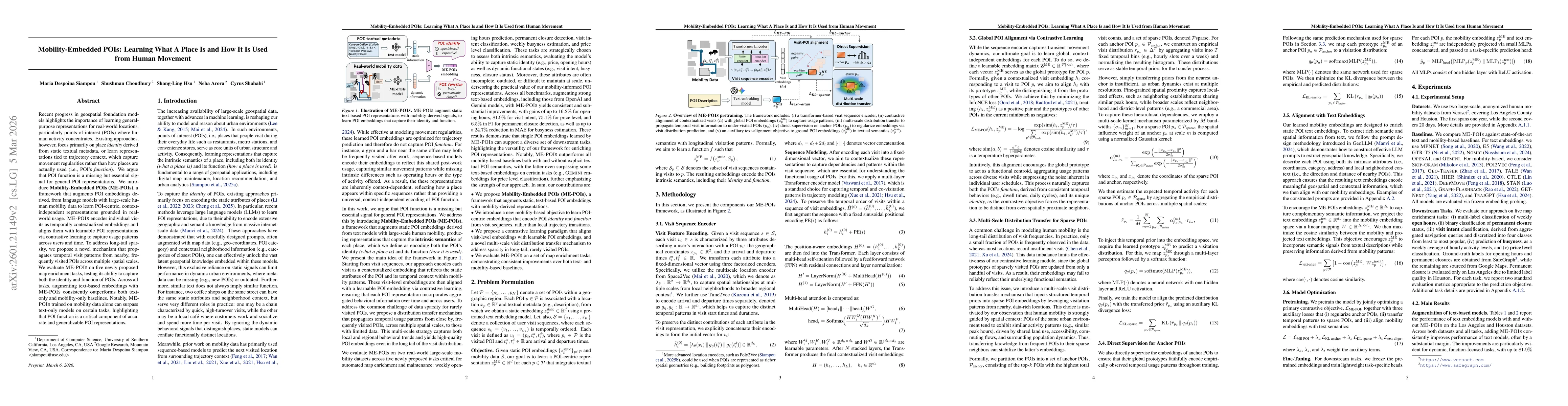
Recent progress in geospatial foundation models highlights the importance of learning general-purpose representations for real-world locations, particularly points-of-interest (POIs) where human activ...
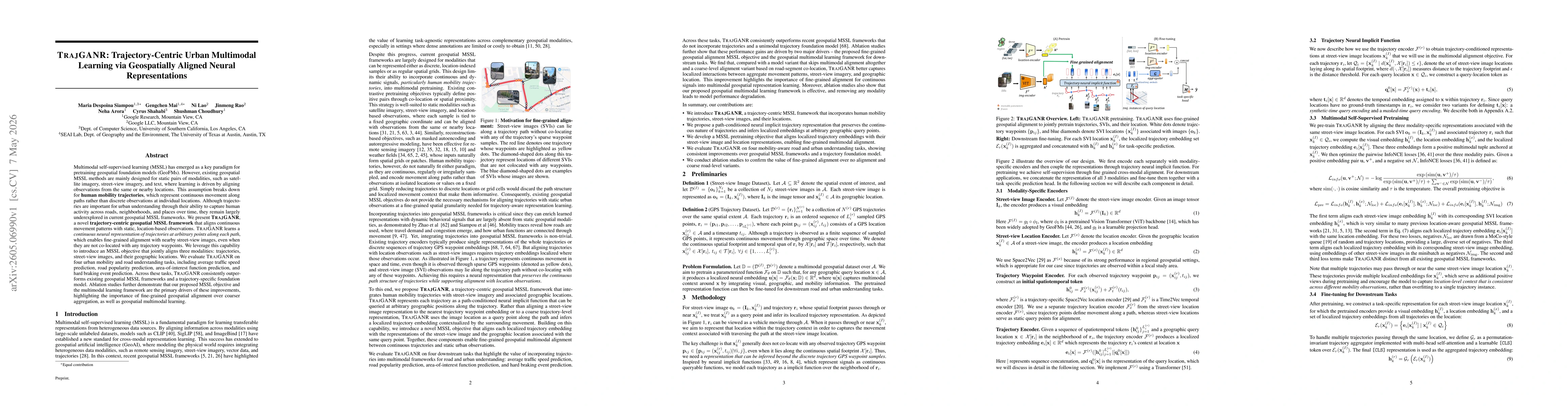
Multimodal self-supervised learning (MSSL) has emerged as a key paradigm for pretraining geospatial foundation models. However, existing geospatial MSSL methods are mainly designed for static pairs of...
Human mobility differs from text and from generic time series in three structural ways: visits are tuple-valued events whose meaning depends on the joint distribution over location, time, and activity...
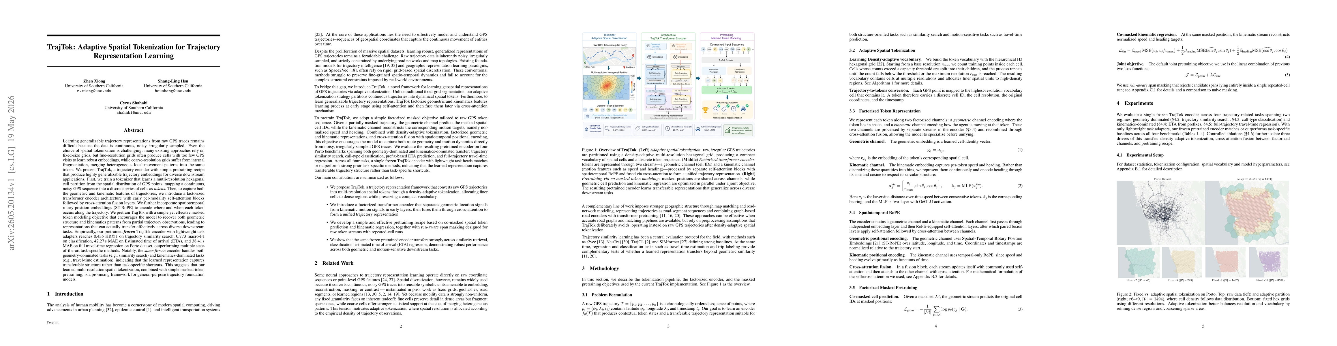
Learning generalizable trajectory representations from raw GPS traces remains difficult because the data is continuous, noisy, and irregularly sampled. Spatial tokenization is also challenging: fine g...
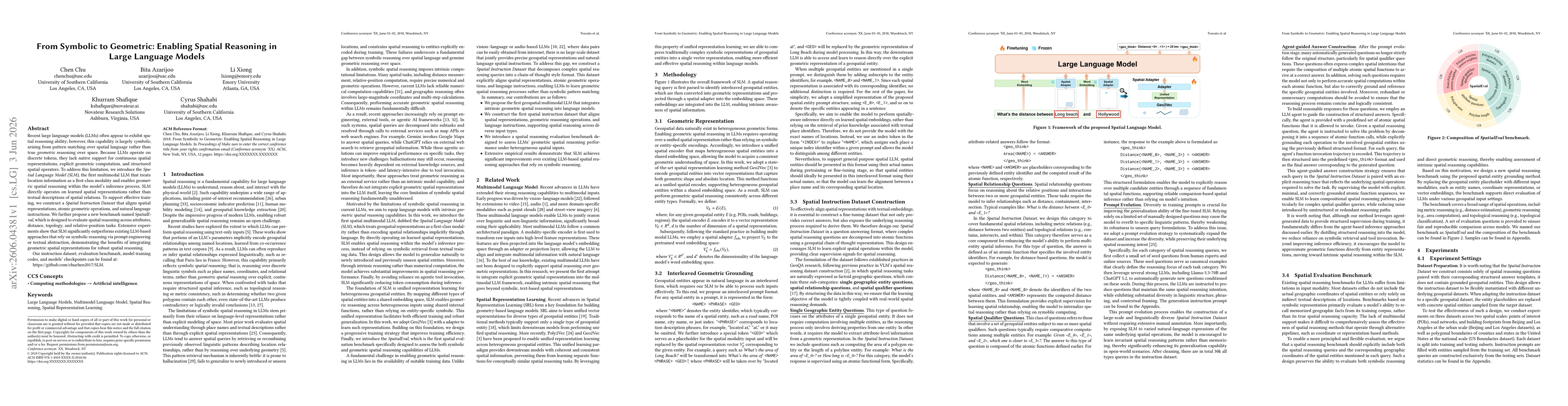
Recent large language models (LLMs) often appear to exhibit spatial reasoning ability; however, this capability is largely \emph{symbolic}, arising from pattern matching over spatial language rather t...
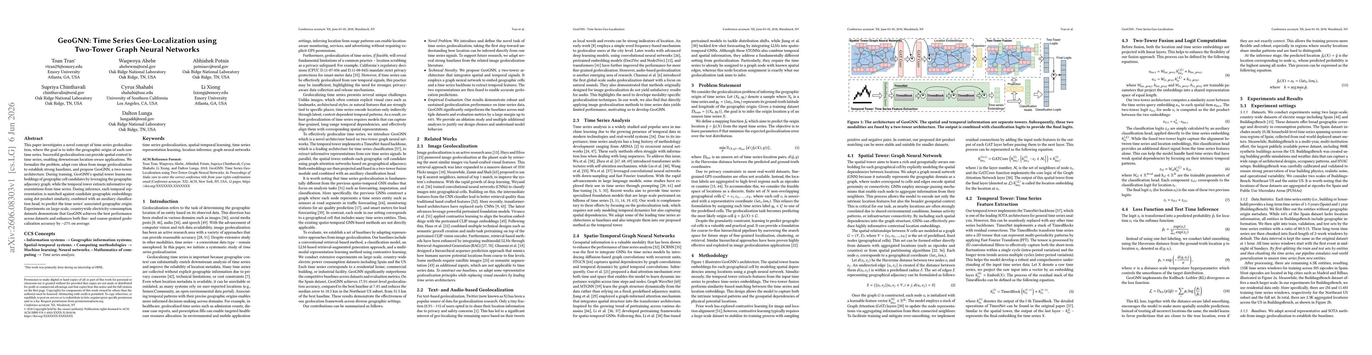
This paper investigates a novel concept of time series geolocalization, where the goal is to infer the geographic origin of each raw time series. Successful geolocalization can provide spatial context...
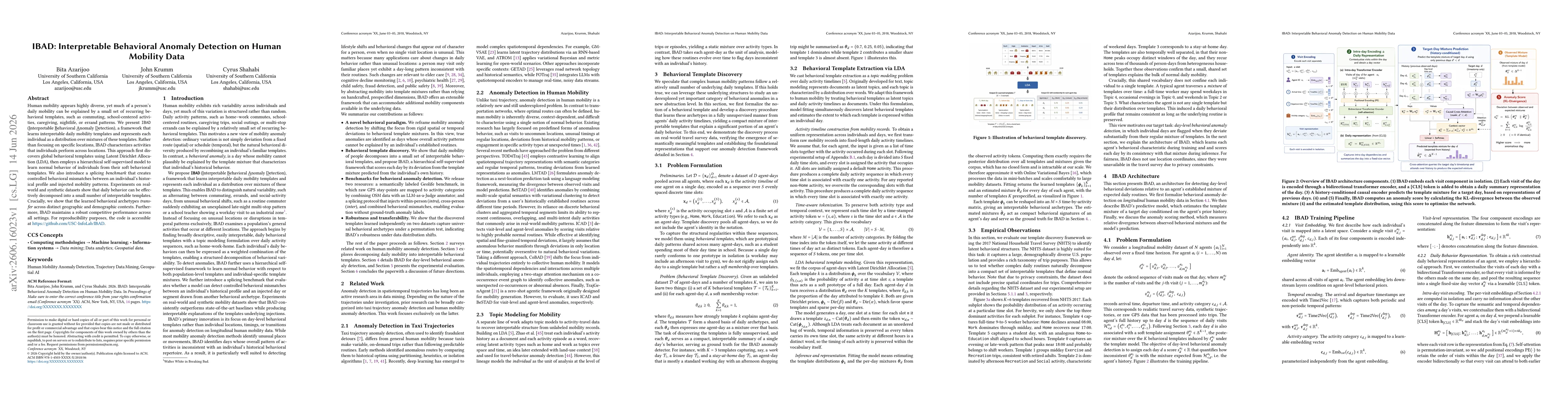
Human mobility appears highly diverse, yet much of a person's daily mobility can be explained by a small set of recurring behavioral templates, such as commuting, school-centered activities, caregivin...
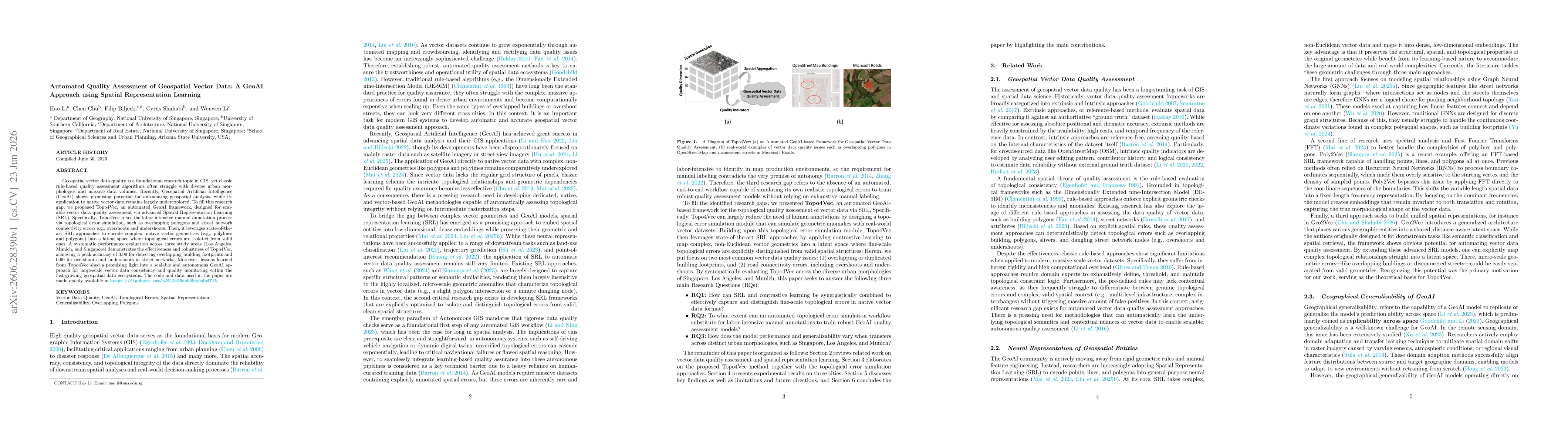
Geospatial vector data quality is a foundational research topic in GIS, yet classic rule-based quality assessment algorithms often struggle with diverse urban morphologies and massive data volumes. Re...