Academic Profile
Statistics
Similar Authors
Papers on arXiv
Convolutional Neural Networks (CNNs) and vision transformers (ViTs) have shown excellent capability in complex hyperspectral image (HSI) classification. However, these models require a significant n...
Semantic segmentation, as a basic tool for intelligent interpretation of remote sensing images, plays a vital role in many Earth Observation (EO) applications. Nowadays, accurate semantic segmentati...
Insufficient prior knowledge of a captured hyperspectral image (HSI) scene may lead the experts or the automatic labeling systems to offer incorrect labels or ambiguous labels (i.e., assigning each ...
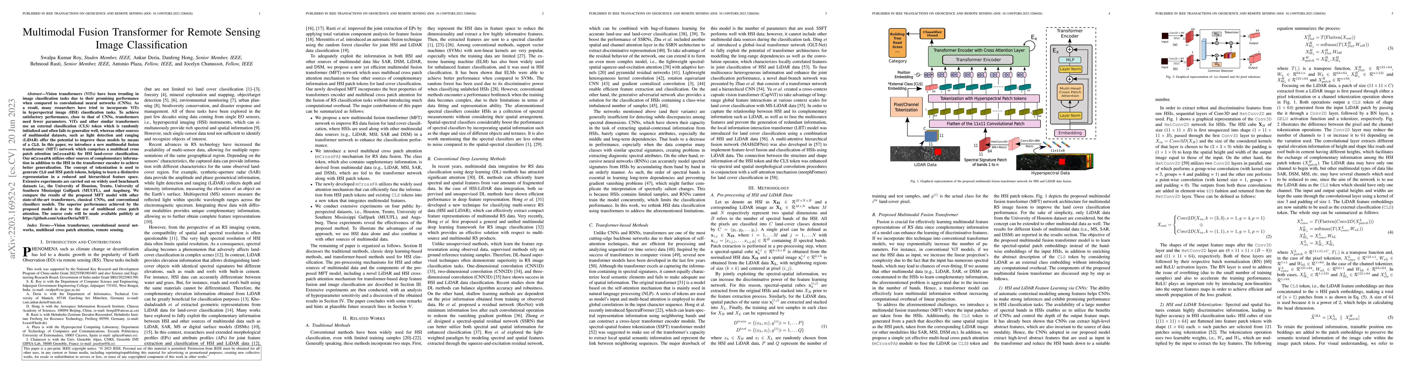
Hyperspectral Image Classification (HSC) is a challenging task due to the high dimensionality and complex nature of Hyperspectral (HS) data. Traditional Machine Learning approaches while effective, ...
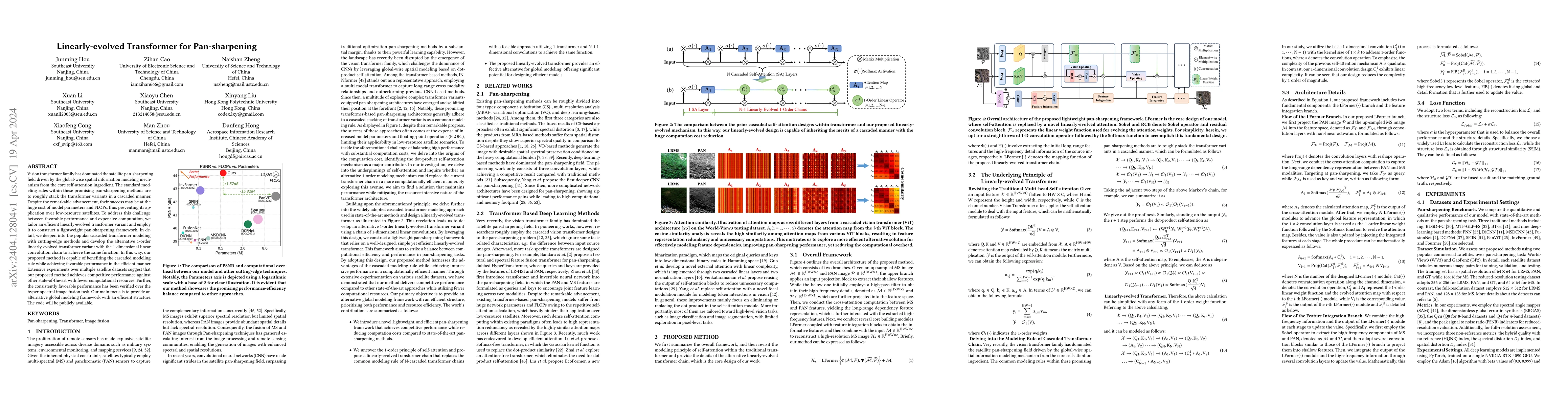
Vision transformer family has dominated the satellite pan-sharpening field driven by the global-wise spatial information modeling mechanism from the core self-attention ingredient. The standard mode...
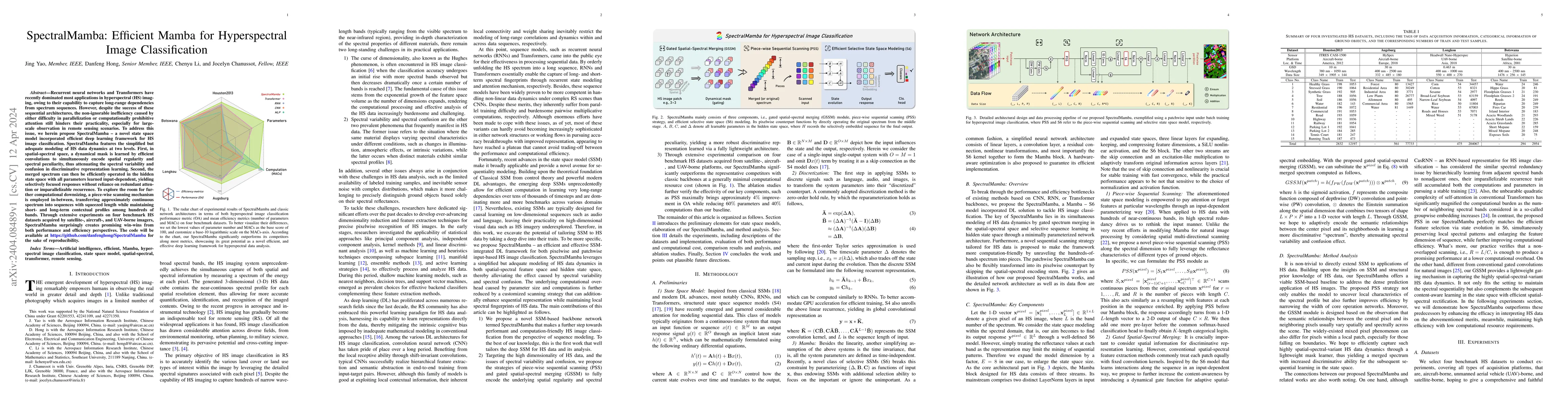
Recurrent neural networks and Transformers have recently dominated most applications in hyperspectral (HS) imaging, owing to their capability to capture long-range dependencies from spectrum sequenc...
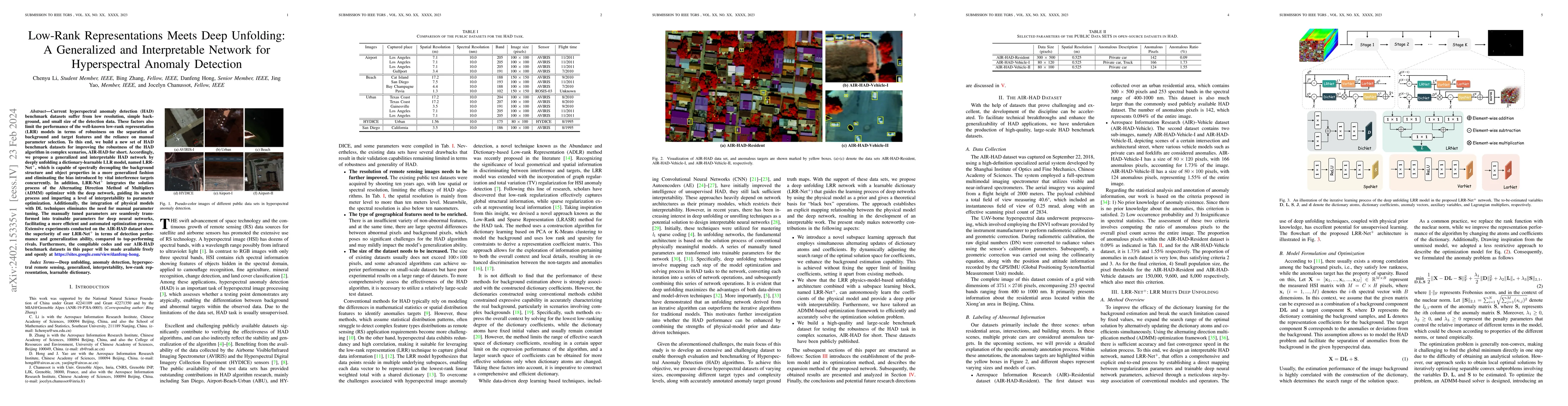
Current hyperspectral anomaly detection (HAD) benchmark datasets suffer from low resolution, simple background, and small size of the detection data. These factors also limit the performance of the ...
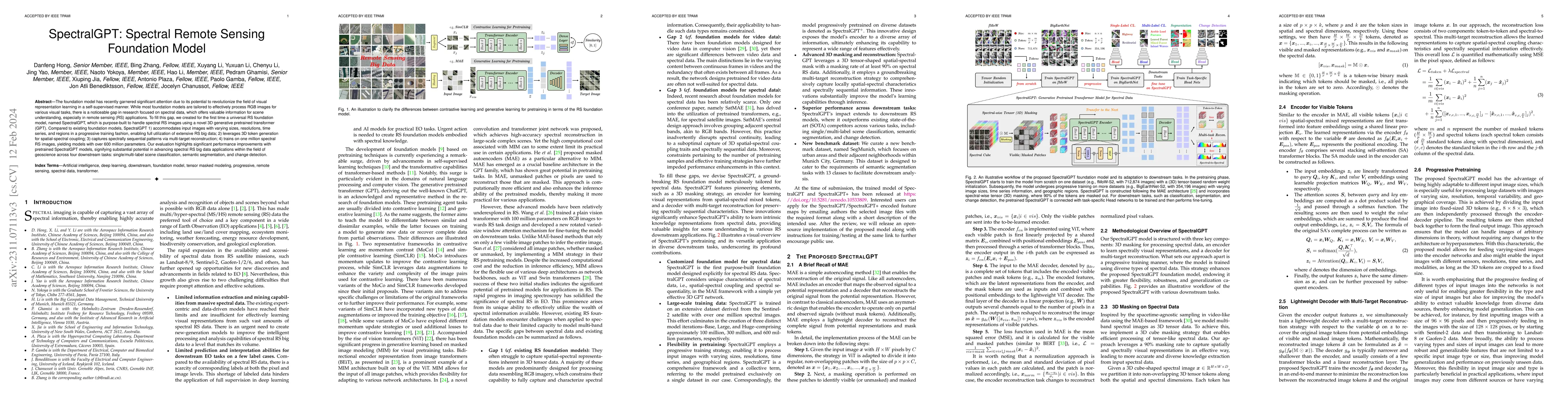
The foundation model has recently garnered significant attention due to its potential to revolutionize the field of visual representation learning in a self-supervised manner. While most foundation ...
Artificial intelligence (AI) approaches nowadays have gained remarkable success in single-modality-dominated remote sensing (RS) applications, especially with an emphasis on individual urban environ...
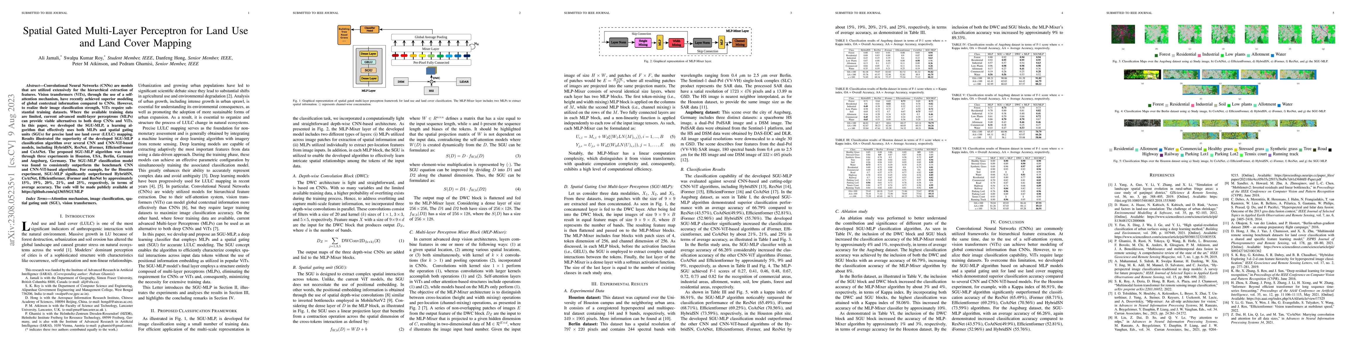
Convolutional Neural Networks (CNNs) are models that are utilized extensively for the hierarchical extraction of features. Vision transformers (ViTs), through the use of a self-attention mechanism, ...
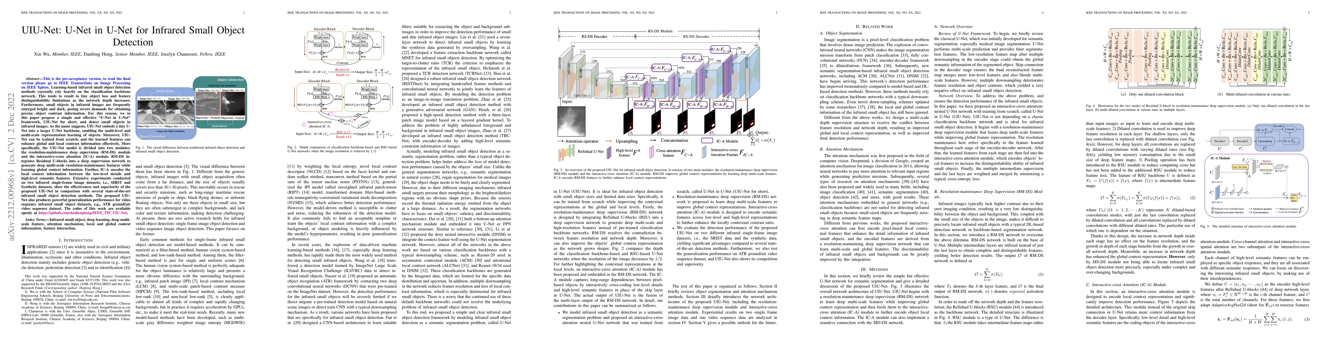
Learning-based infrared small object detection methods currently rely heavily on the classification backbone network. This tends to result in tiny object loss and feature distinguishability limitati...
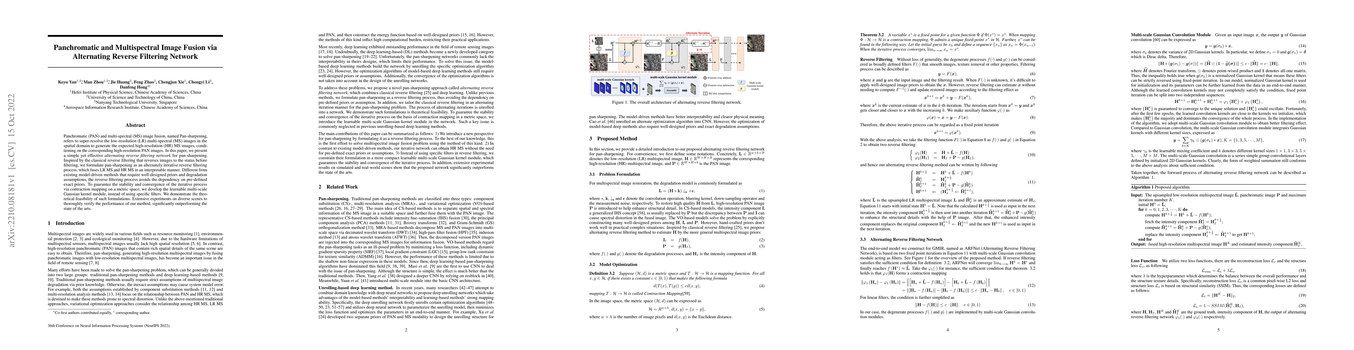
Panchromatic (PAN) and multi-spectral (MS) image fusion, named Pan-sharpening, refers to super-resolve the low-resolution (LR) multi-spectral (MS) images in the spatial domain to generate the expect...
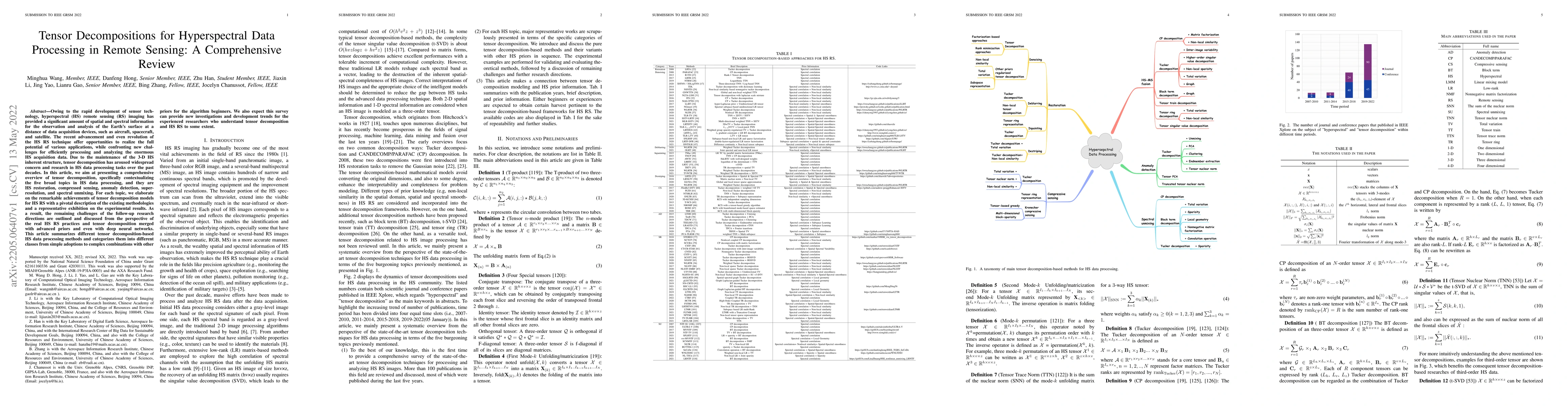
Owing to the rapid development of sensor technology, hyperspectral (HS) remote sensing (RS) imaging has provided a significant amount of spatial and spectral information for the observation and anal...
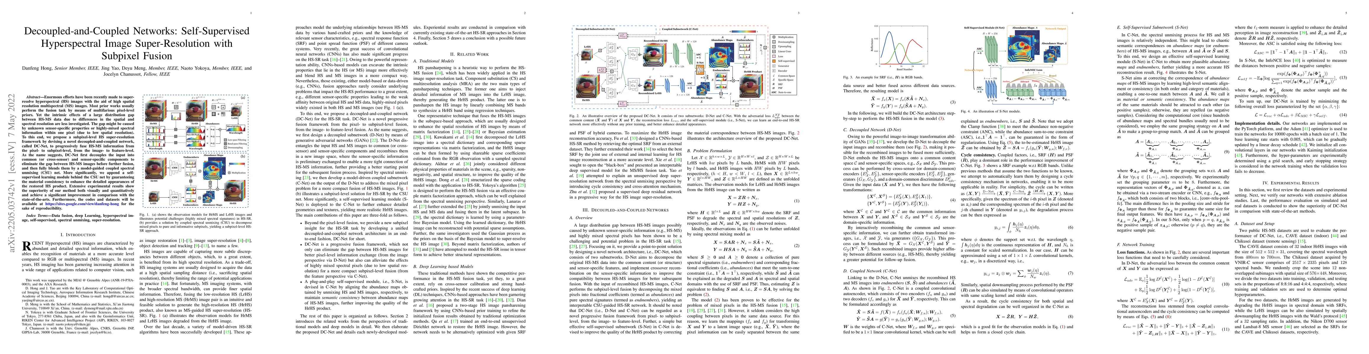
Enormous efforts have been recently made to super-resolve hyperspectral (HS) images with the aid of high spatial resolution multispectral (MS) images. Most prior works usually perform the fusion tas...
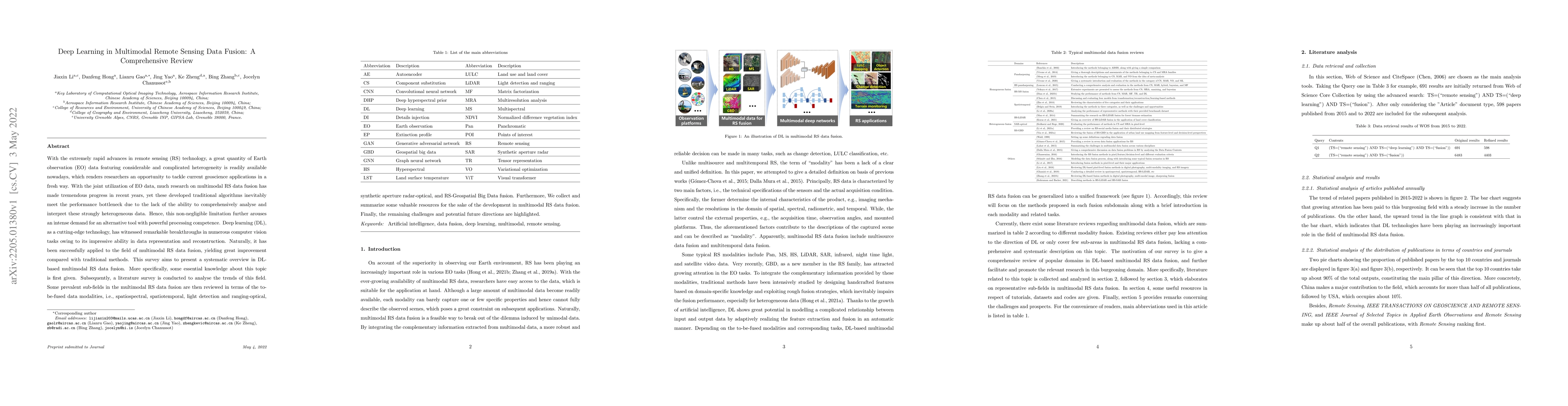
With the extremely rapid advances in remote sensing (RS) technology, a great quantity of Earth observation (EO) data featuring considerable and complicated heterogeneity is readily available nowaday...
Vision transformers (ViTs) have been trending in image classification tasks due to their promising performance when compared to convolutional neural networks (CNNs). As a result, many researchers ha...
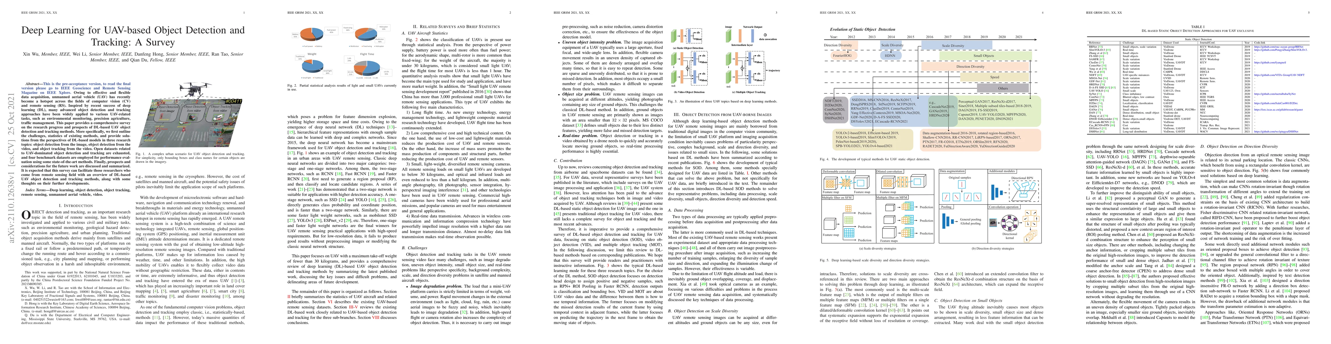
Owing to effective and flexible data acquisition, unmanned aerial vehicle (UAV) has recently become a hotspot across the fields of computer vision (CV) and remote sensing (RS). Inspired by recent su...
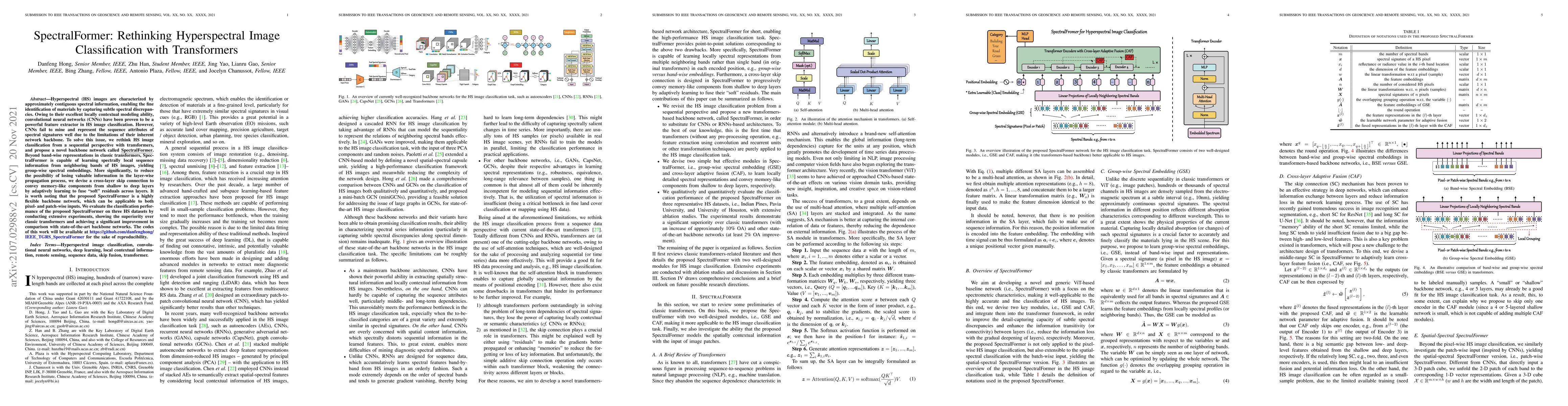
Hyperspectral (HS) images are characterized by approximately contiguous spectral information, enabling the fine identification of materials by capturing subtle spectral discrepancies. Owing to their...
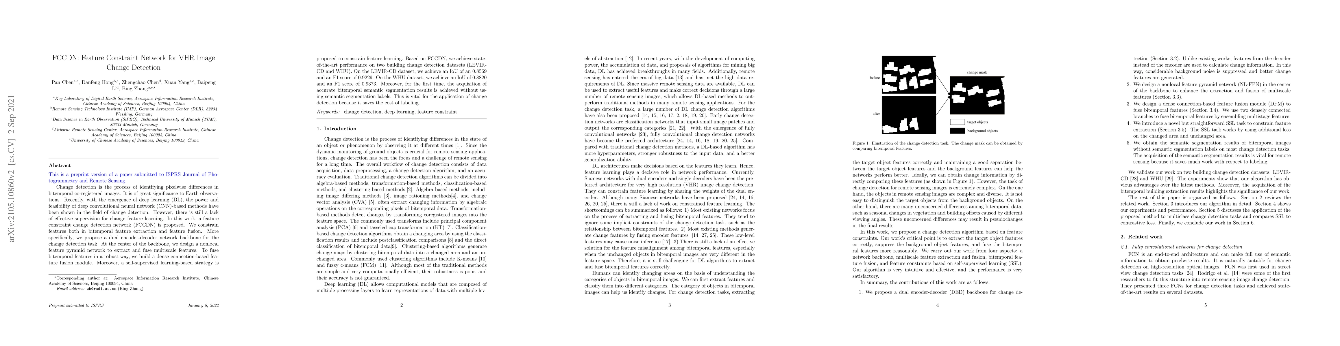
Change detection is the process of identifying pixelwise differences in bitemporal co-registered images. It is of great significance to Earth observations. Recently, with the emergence of deep learn...
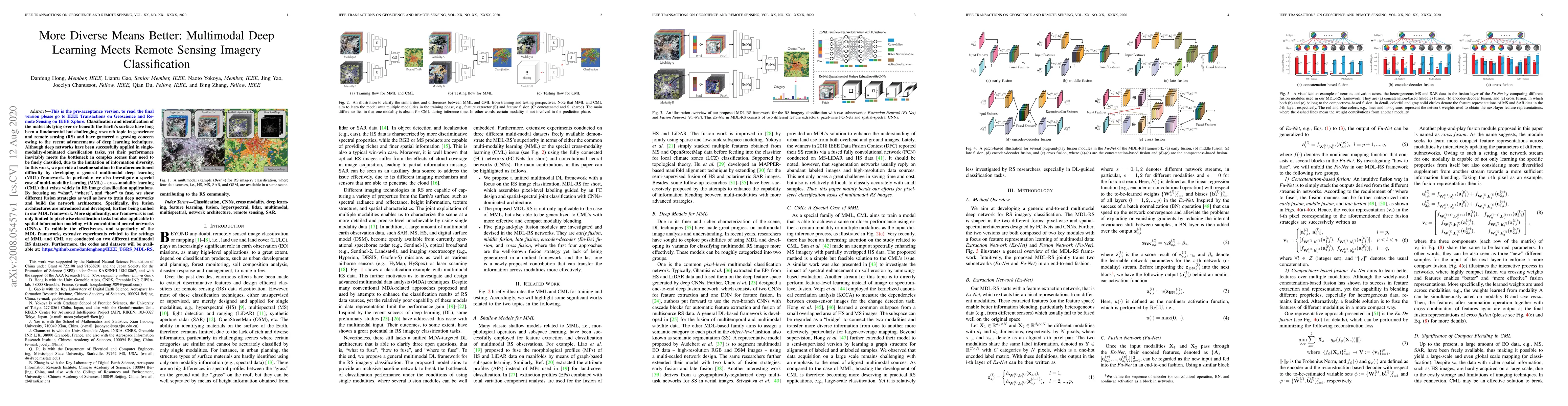
As remote sensing (RS) data obtained from different sensors become available largely and openly, multimodal data processing and analysis techniques have been garnering increasing interest in the RS ...
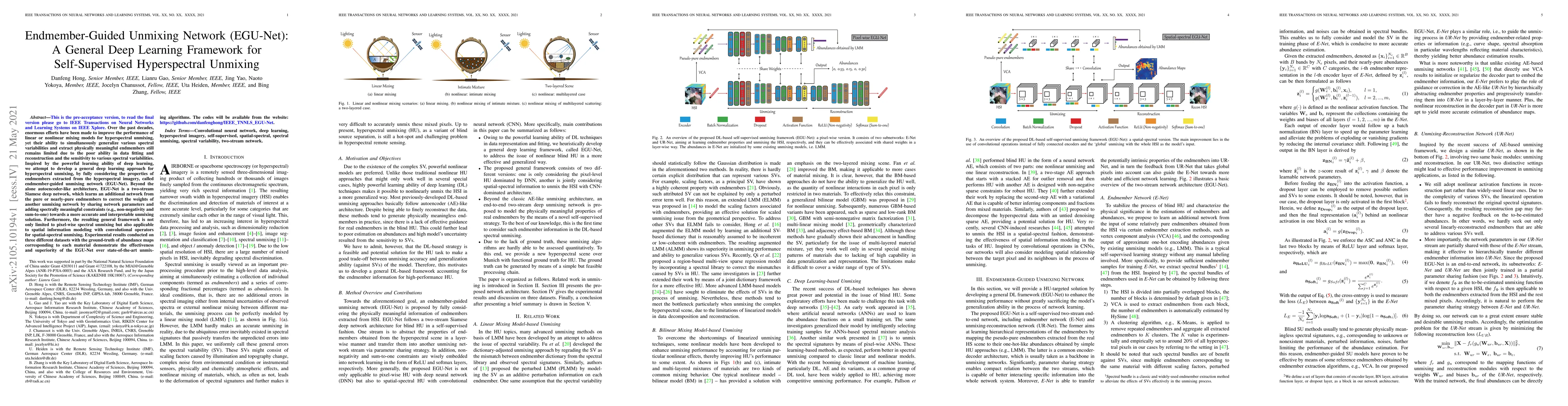
Over the past decades, enormous efforts have been made to improve the performance of linear or nonlinear mixing models for hyperspectral unmixing, yet their ability to simultaneously generalize vari...
Hyperspectral imaging, also known as image spectrometry, is a landmark technique in geoscience and remote sensing (RS). In the past decade, enormous efforts have been made to process and analyze the...
Hyperspectral Imaging (HSI) has been extensively utilized in many real-life applications because it benefits from the detailed spectral information contained in each pixel. Notably, the complex char...
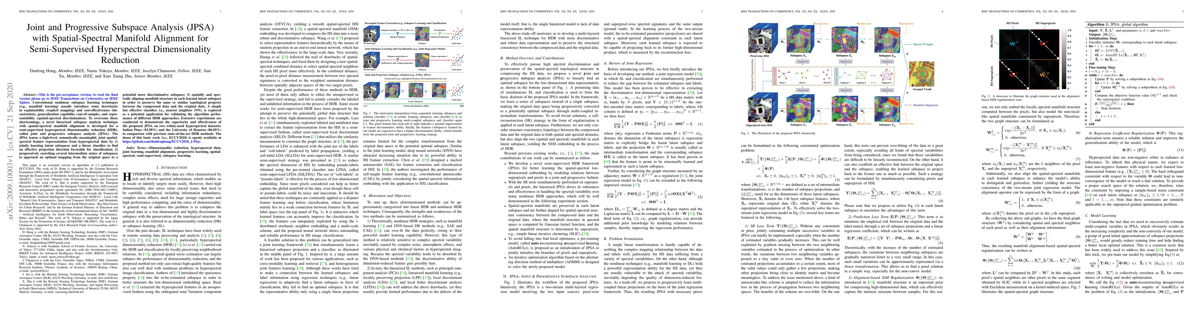
Conventional nonlinear subspace learning techniques (e.g., manifold learning) usually introduce some drawbacks in explainability (explicit mapping) and cost-effectiveness (linearization), generaliza...
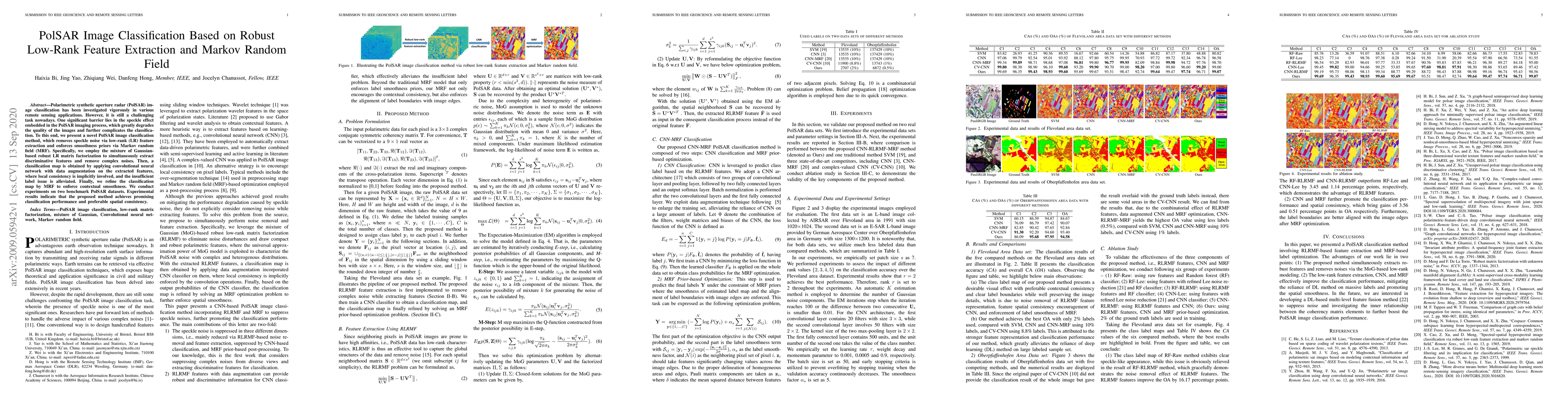
Polarimetric synthetic aperture radar (PolSAR) image classification has been investigated vigorously in various remote sensing applications. However, it is still a challenging task nowadays. One sig...
Classification and identification of the materials lying over or beneath the Earth's surface have long been a fundamental but challenging research topic in geoscience and remote sensing (RS) and hav...
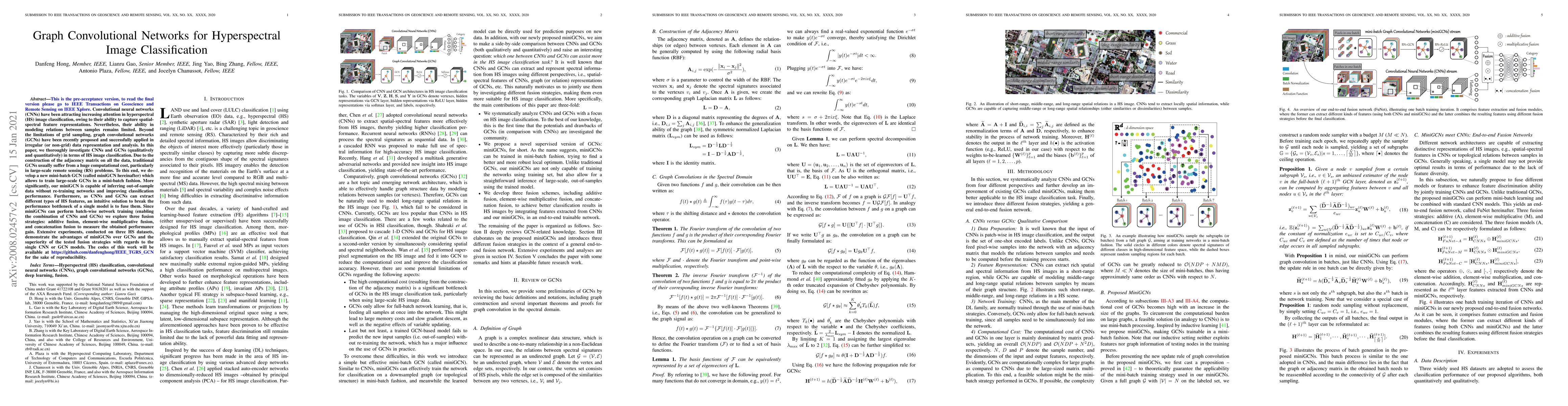
To read the final version please go to IEEE TGRS on IEEE Xplore. Convolutional neural networks (CNNs) have been attracting increasing attention in hyperspectral (HS) image classification, owing to t...
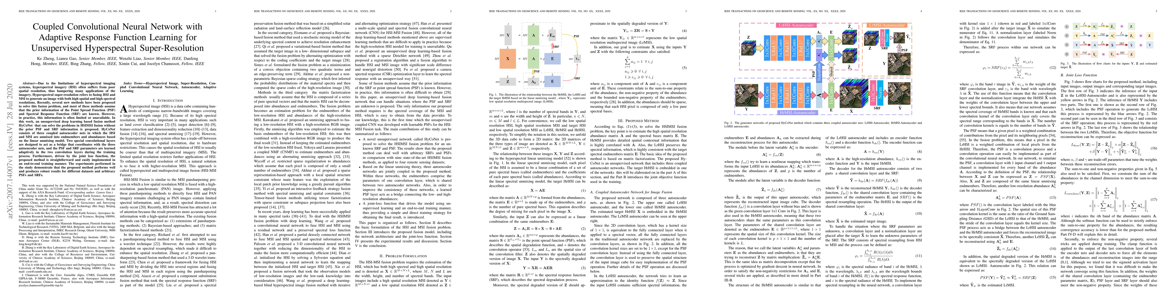
Due to the limitations of hyperspectral imaging systems, hyperspectral imagery (HSI) often suffers from poor spatial resolution, thus hampering many applications of the imagery. Hyperspectral super-...
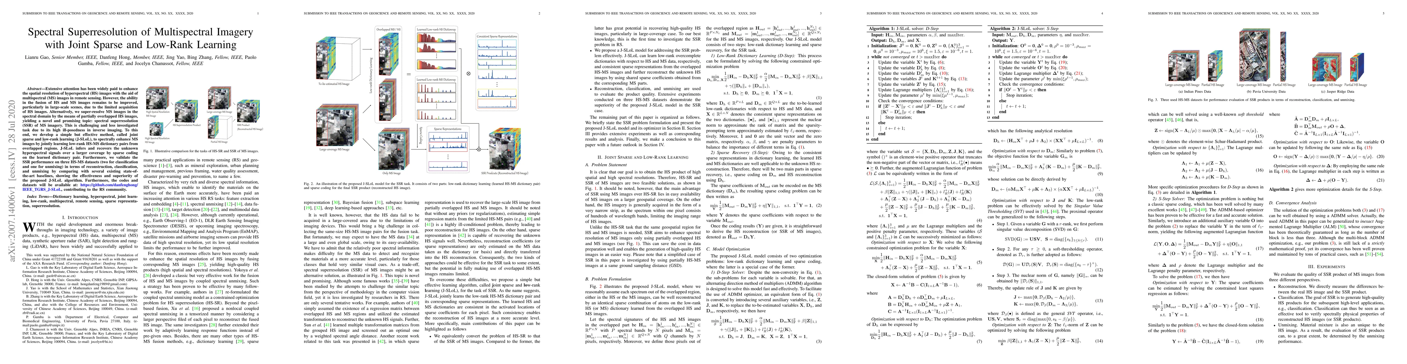
Extensive attention has been widely paid to enhance the spatial resolution of hyperspectral (HS) images with the aid of multispectral (MS) images in remote sensing. However, the ability in the fusio...
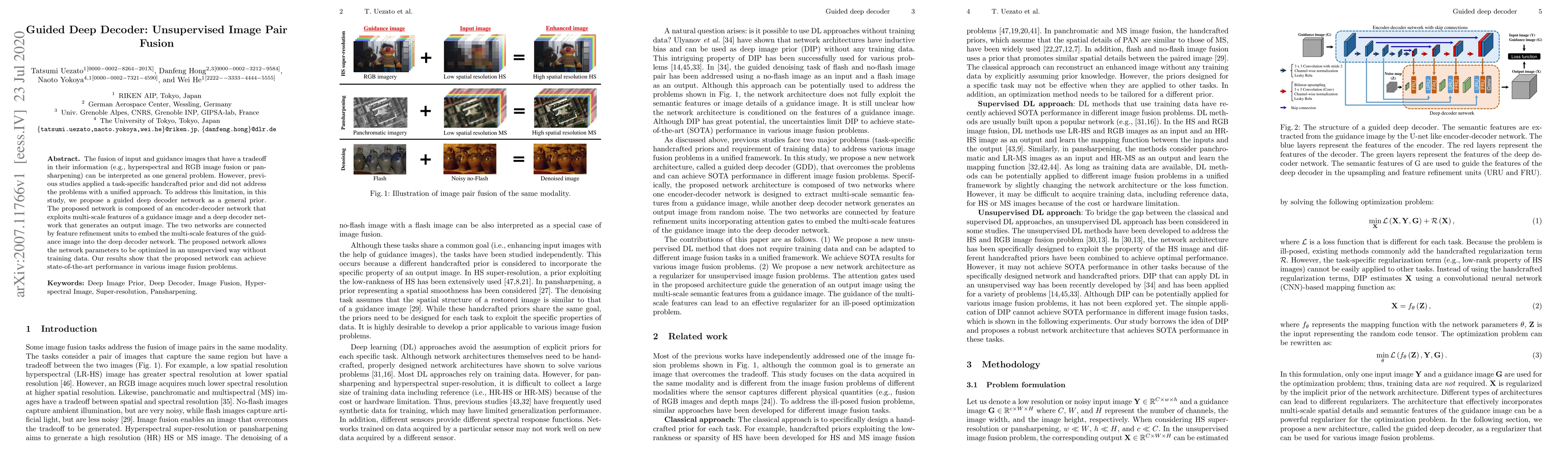
The fusion of input and guidance images that have a tradeoff in their information (e.g., hyperspectral and RGB image fusion or pansharpening) can be interpreted as one general problem. However, prev...
In recent years, hyperspectral imaging, also known as imaging spectroscopy, has been paid an increasing interest in geoscience and remote sensing community. Hyperspectral imagery is characterized by...
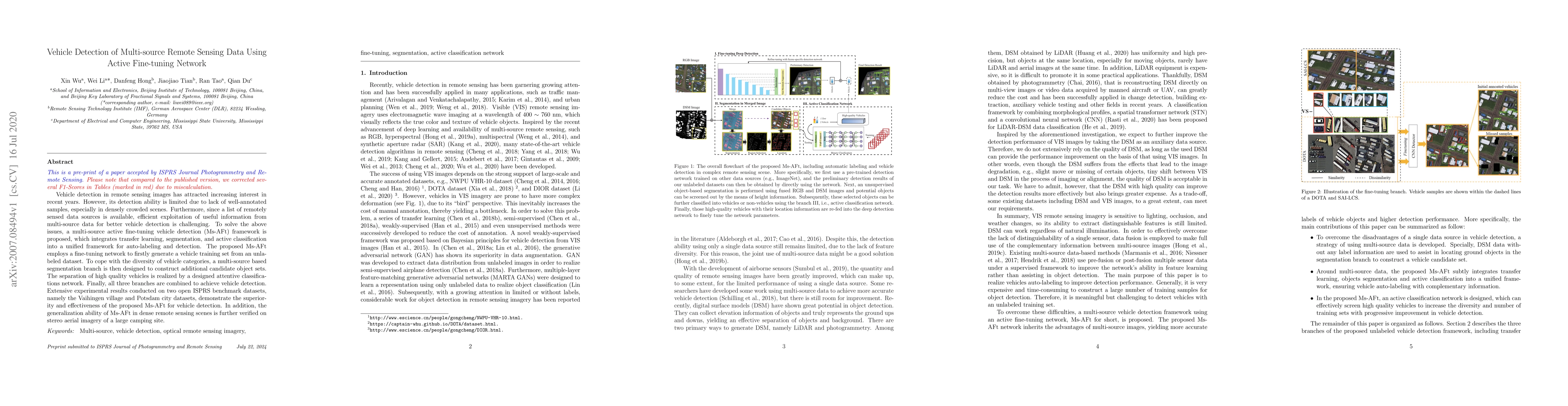
Vehicle detection in remote sensing images has attracted increasing interest in recent years. However, its detection ability is limited due to lack of well-annotated samples, especially in densely c...
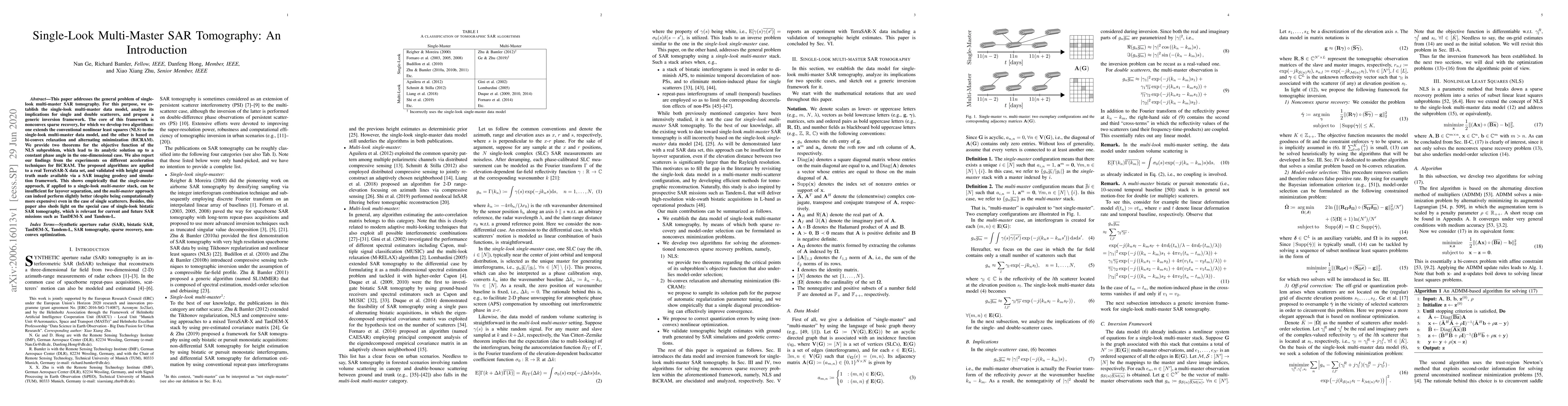
This paper addresses the general problem of single-look multi-master SAR tomography. For this purpose, we establish the single-look multi-master data model, analyze its implications for single and d...
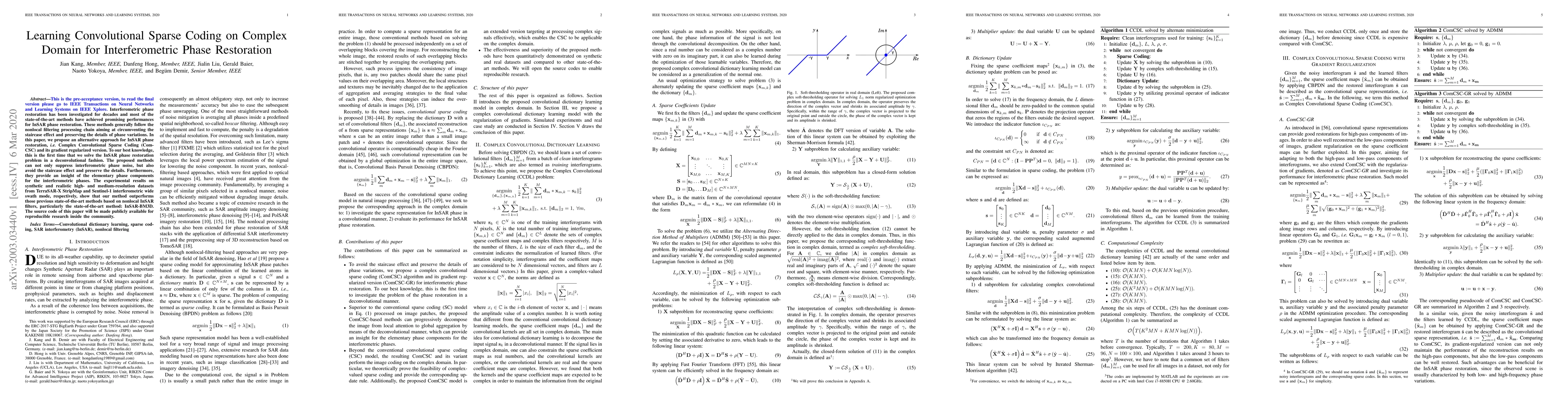
Interferometric phase restoration has been investigated for decades and most of the state-of-the-art methods have achieved promising performances for InSAR phase restoration. These methods generally...
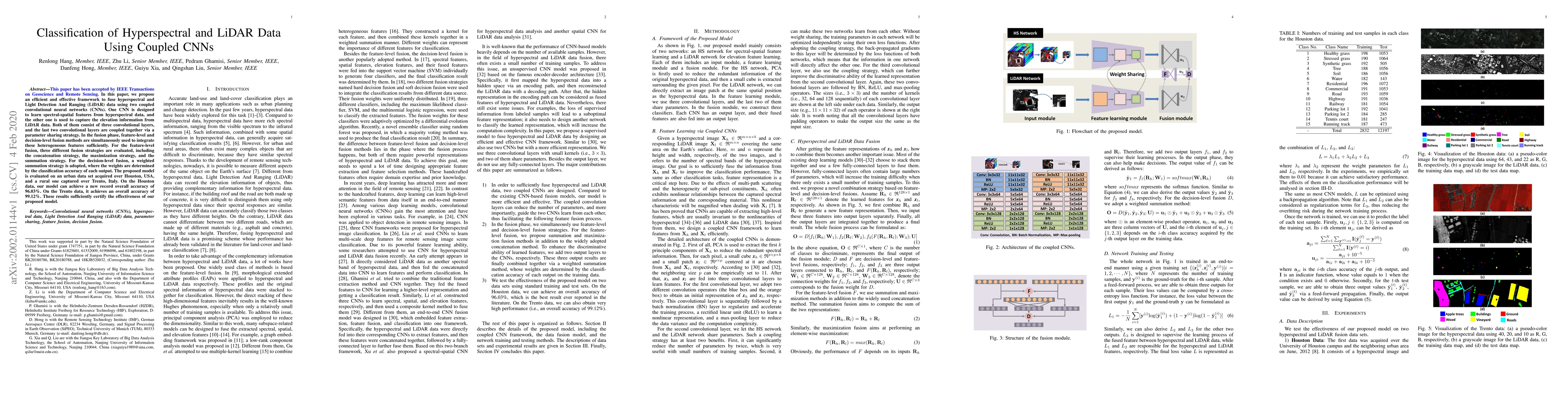
In this paper, we propose an efficient and effective framework to fuse hyperspectral and Light Detection And Ranging (LiDAR) data using two coupled convolutional neural networks (CNNs). One CNN is d...
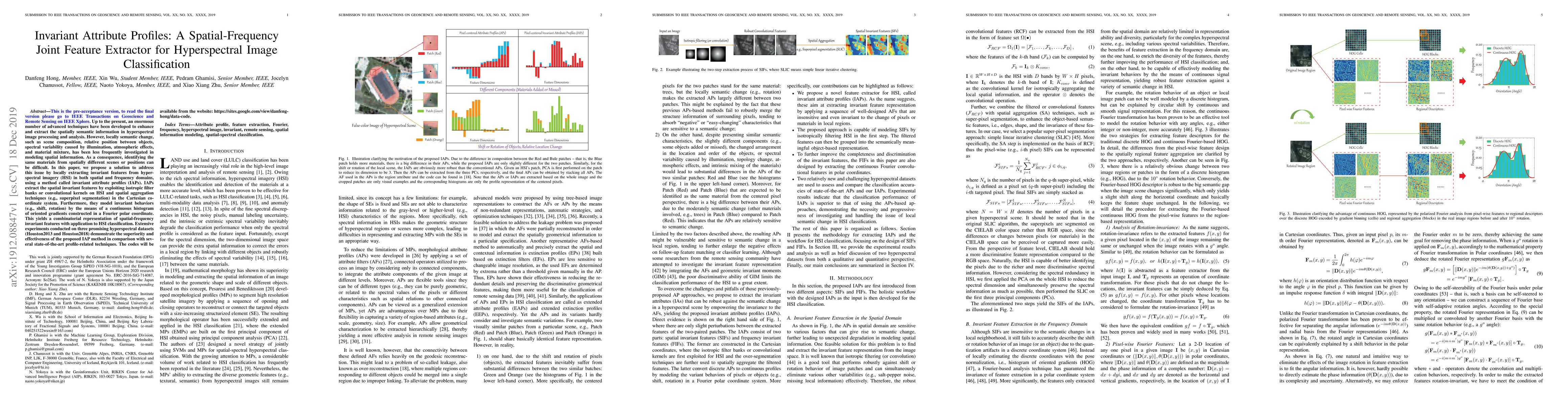
Up to the present, an enormous number of advanced techniques have been developed to enhance and extract the spatially semantic information in hyperspectral image processing and analysis. However, lo...
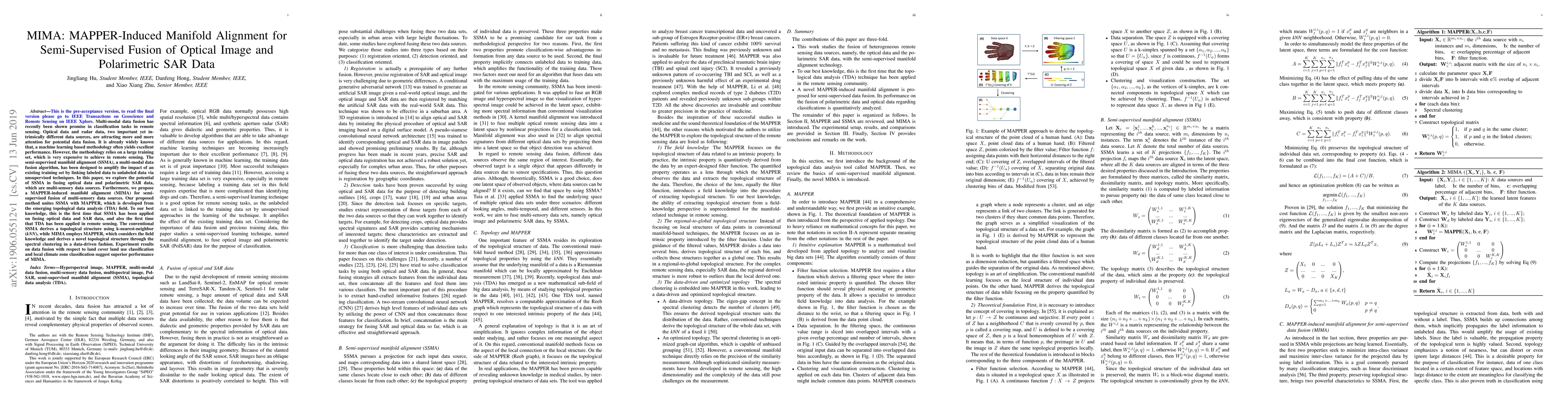
Multi-modal data fusion has recently been shown promise in classification tasks in remote sensing. Optical data and radar data, two important yet intrinsically different data sources, are attracting...
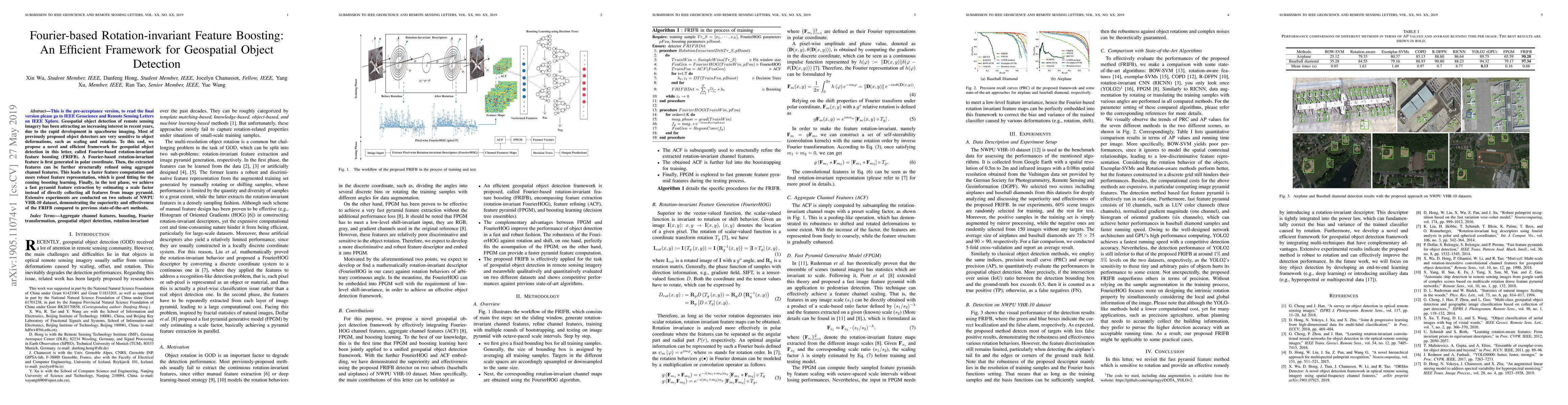
Geospatial object detection of remote sensing imagery has been attracting an increasing interest in recent years, due to the rapid development in spaceborne imaging. Most of previously proposed obje...
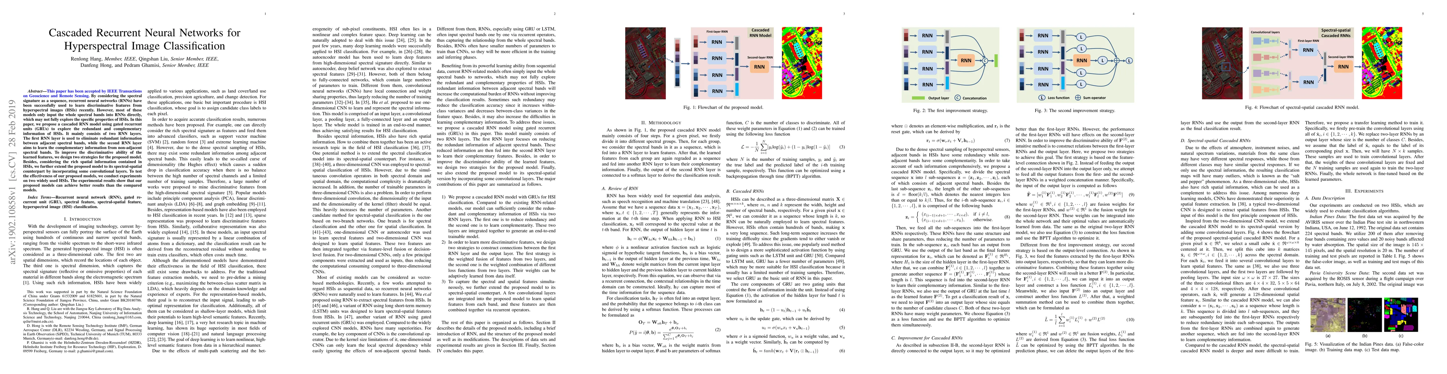
By considering the spectral signature as a sequence, recurrent neural networks (RNNs) have been successfully used to learn discriminative features from hyperspectral images (HSIs) recently. However,...
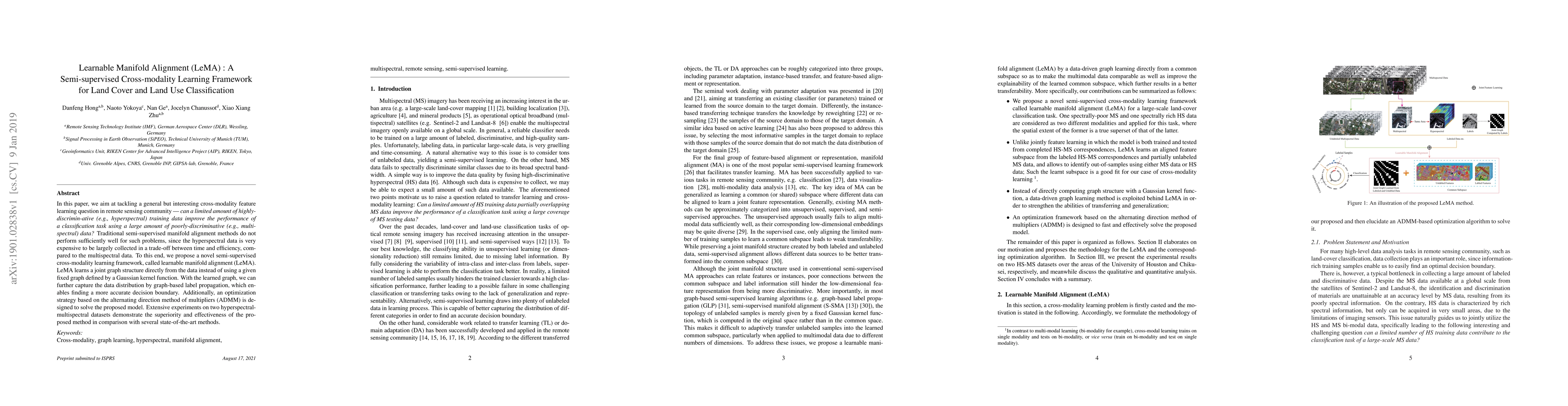
In this paper, we aim at tackling a general but interesting cross-modality feature learning question in remote sensing community --- can a limited amount of highly-discrimin-ative (e.g., hyperspectr...
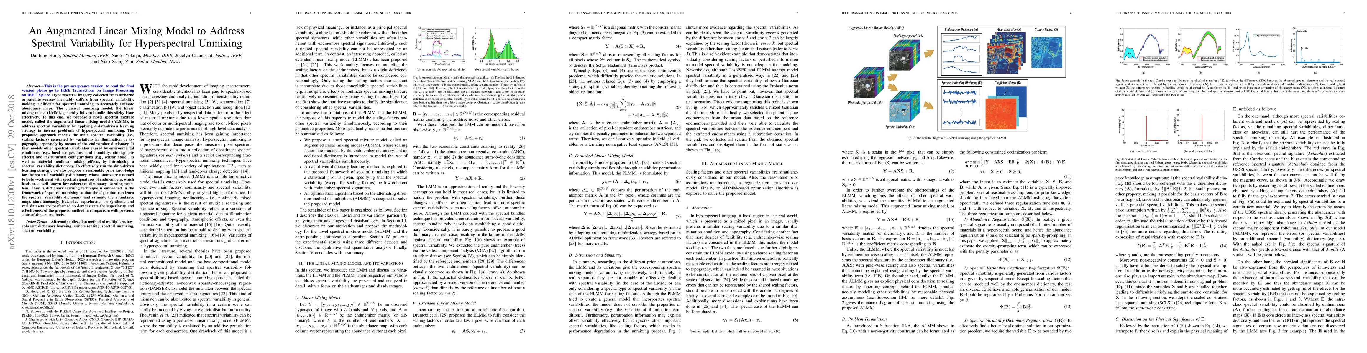
Hyperspectral imagery collected from airborne or satellite sources inevitably suffers from spectral variability, making it difficult for spectral unmixing to accurately estimate abundance maps. The ...
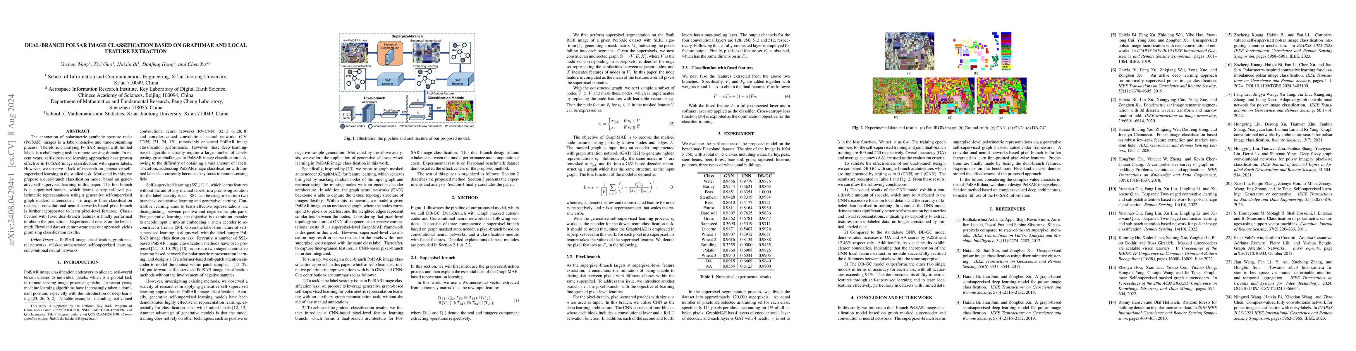
The annotation of polarimetric synthetic aperture radar (PolSAR) images is a labor-intensive and time-consuming process. Therefore, classifying PolSAR images with limited labels is a challenging task ...
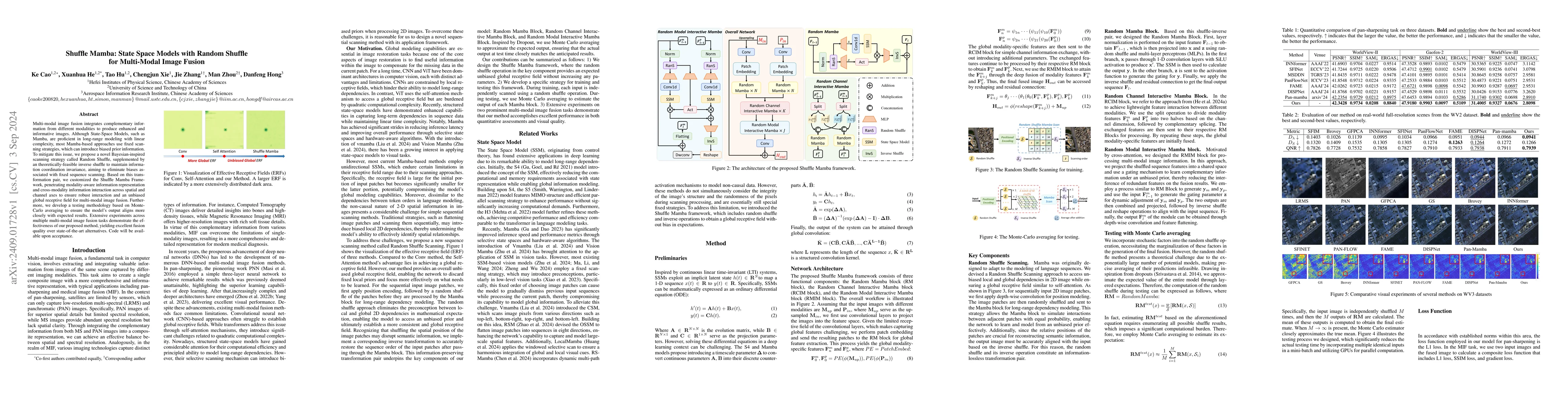
Multi-modal image fusion integrates complementary information from different modalities to produce enhanced and informative images. Although State-Space Models, such as Mamba, are proficient in long-r...
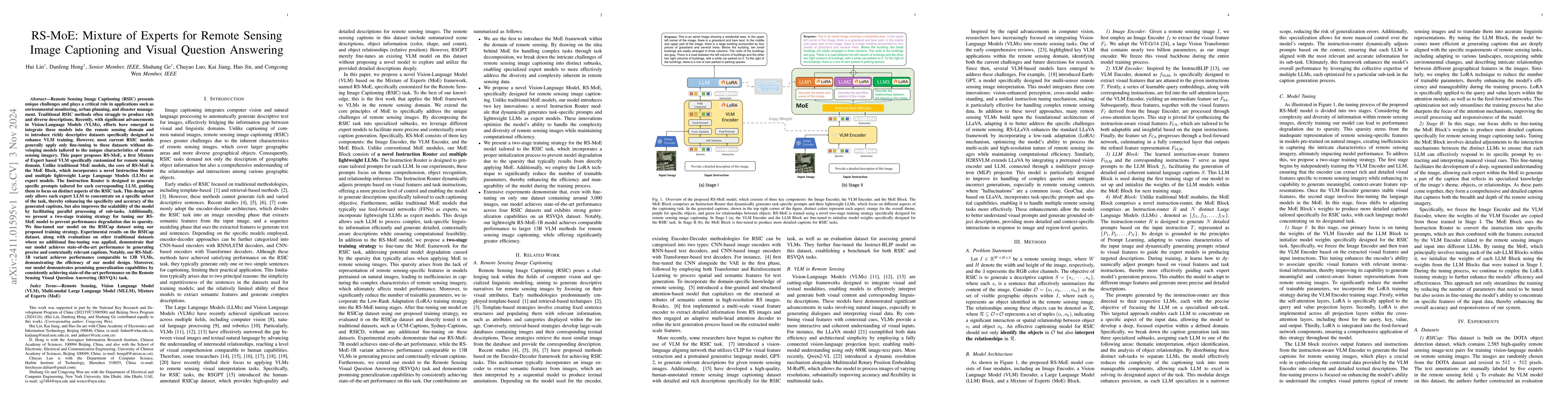
Remote Sensing Image Captioning (RSIC) presents unique challenges and plays a critical role in applications. Traditional RSIC methods often struggle to produce rich and diverse descriptions. Recently,...
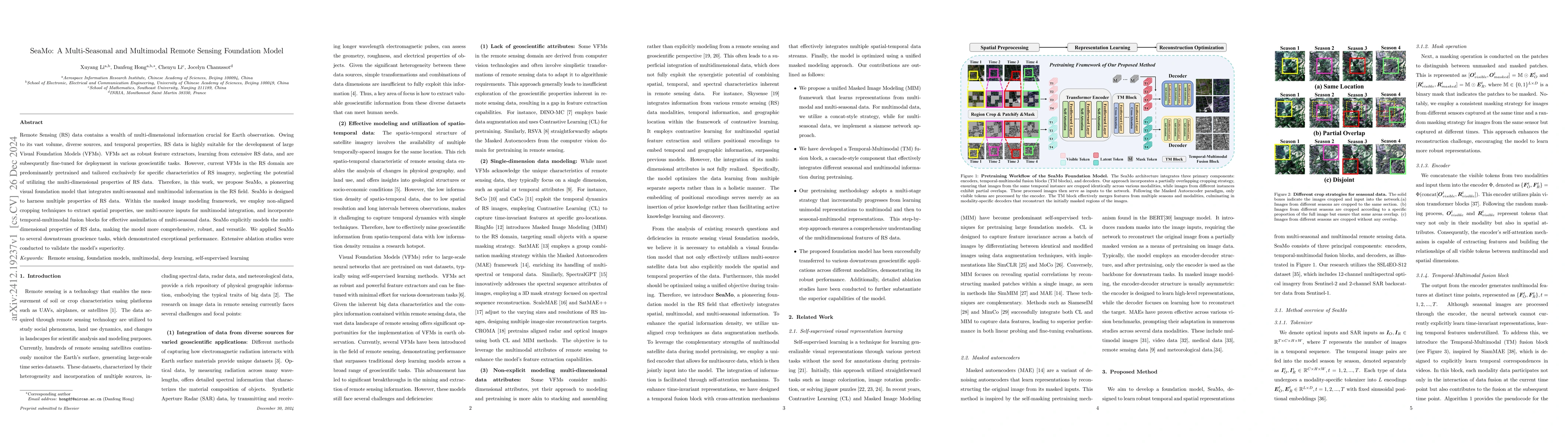
Remote Sensing (RS) data contains a wealth of multi-dimensional information crucial for Earth observation. Owing to its vast volume, diverse sources, and temporal properties, RS data is highly suitabl...
Remote sensing data is often distributed across multiple institutions, and due to privacy concerns and data-sharing restrictions, leveraging large-scale datasets in a centralized training framework is...
Hyperspectral image (HSI) clustering has been a fundamental but challenging task with zero training labels. Currently, some deep graph clustering methods have been successfully explored for HSI due to...
Remote sensing object detection is particularly challenging due to the high resolution, multi-scale features, and diverse ground object characteristics inherent in satellite and UAV imagery. These cha...
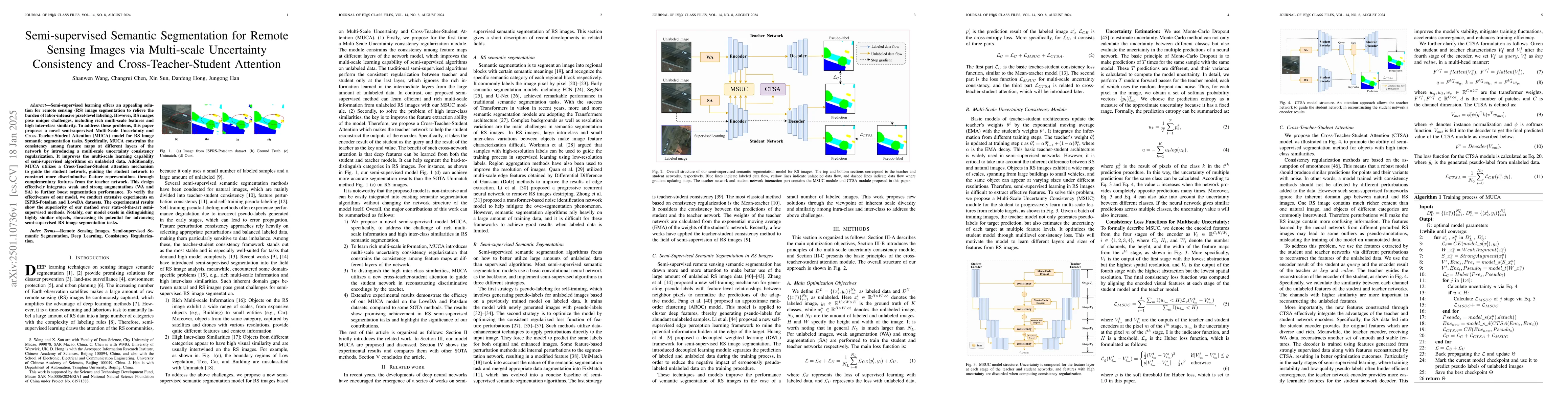
Semi-supervised learning offers an appealing solution for remote sensing (RS) image segmentation to relieve the burden of labor-intensive pixel-level labeling. However, RS images pose unique challenge...
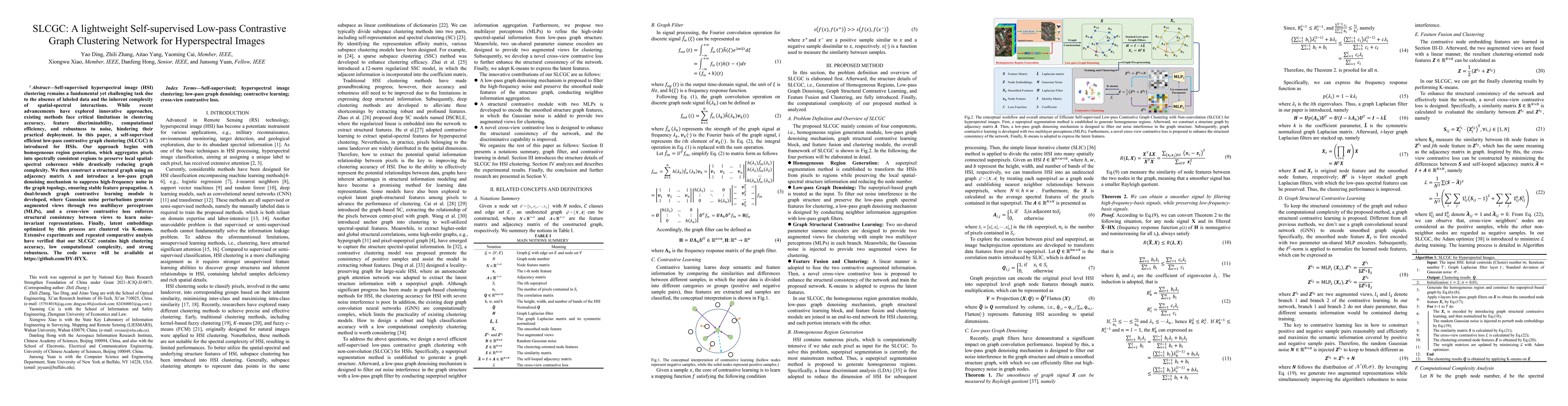
Self-supervised hyperspectral image (HSI) clustering remains a fundamental yet challenging task due to the absence of labeled data and the inherent complexity of spatial-spectral interactions. While r...
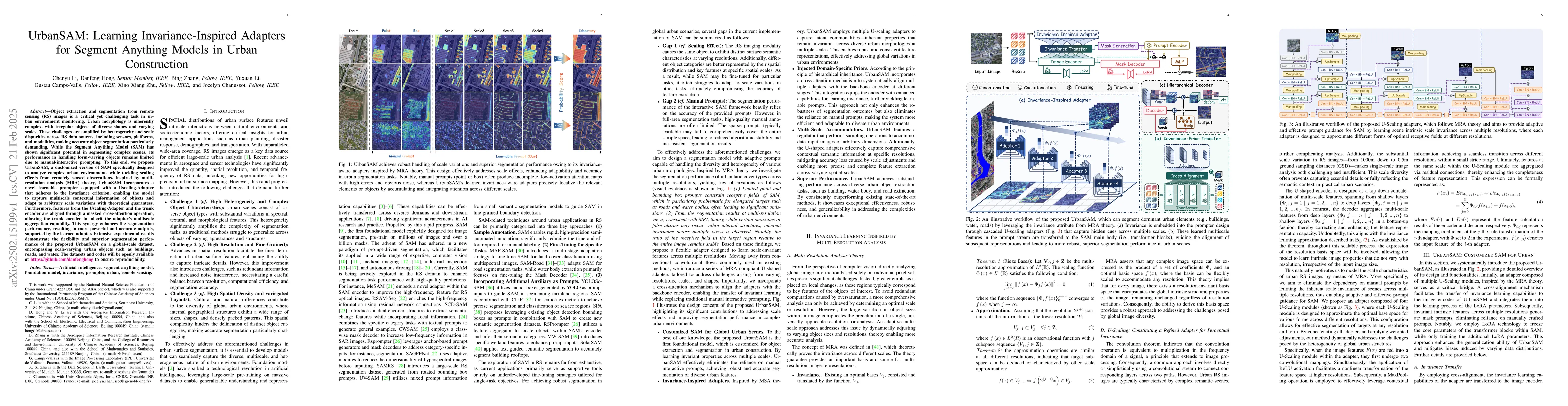
Object extraction and segmentation from remote sensing (RS) images is a critical yet challenging task in urban environment monitoring. Urban morphology is inherently complex, with irregular objects of...
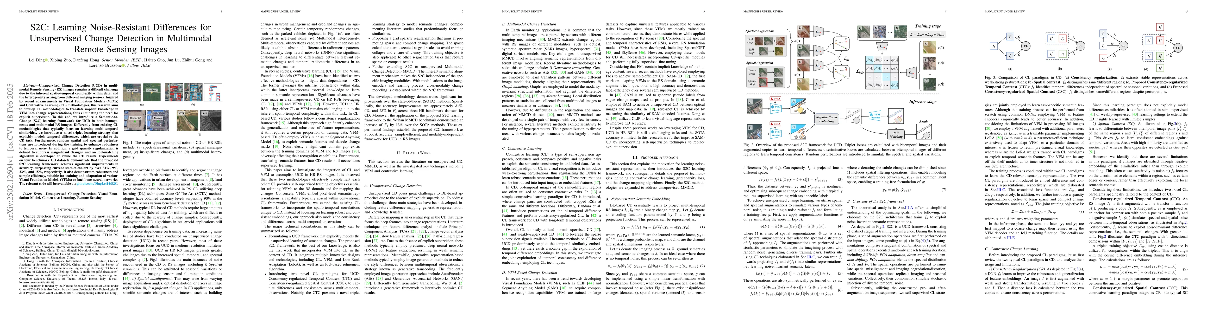
Unsupervised Change Detection (UCD) in multimodal Remote Sensing (RS) images remains a difficult challenge due to the inherent spatio-temporal complexity within data, and the heterogeneity arising fro...
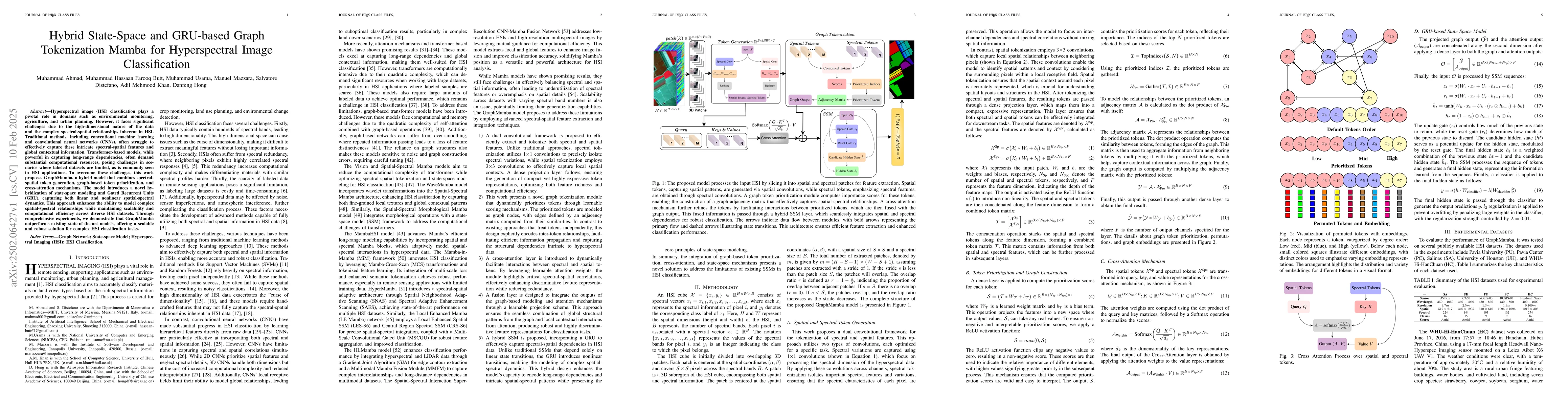
Hyperspectral image (HSI) classification plays a pivotal role in domains such as environmental monitoring, agriculture, and urban planning. However, it faces significant challenges due to the high-dim...
In the last decade, the rapid development of deep learning (DL) has made it possible to perform automatic, accurate, and robust Change Detection (CD) on large volumes of Remote Sensing Images (RSIs). ...
We propose a novel joint framework by integrating super-resolution and segmentation, called JointSeg, which enables the generation of 1-meter ISA maps directly from freely available Sentinel-2 imagery...
Hyperspectral image processing and analysis has important application value in remote sensing, agriculture and environmental monitoring, but its high dimensionality, data redundancy and noise interfer...
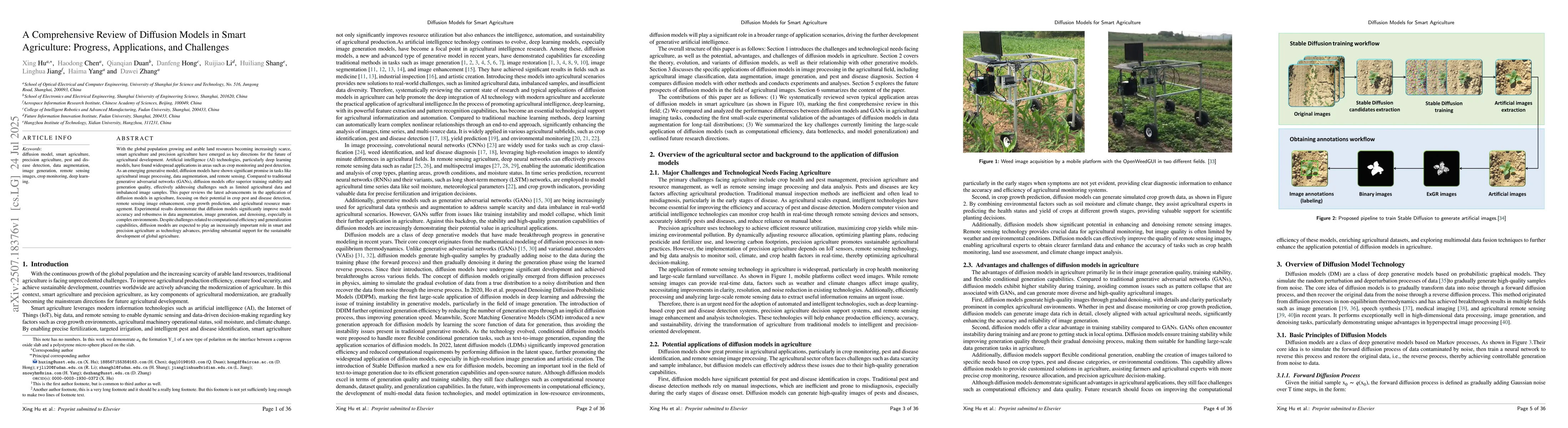
With the global population growing and arable land resources becoming increasingly scarce,smart agriculture and precision agriculture have emerged as key directions for the future ofagricultural devel...
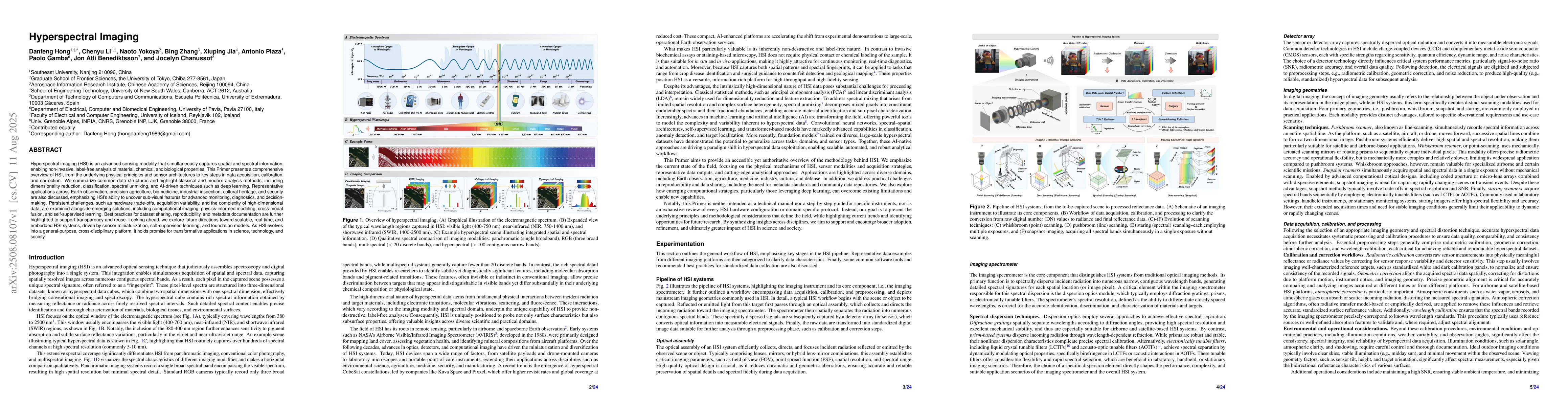
Hyperspectral imaging (HSI) is an advanced sensing modality that simultaneously captures spatial and spectral information, enabling non-invasive, label-free analysis of material, chemical, and biologi...
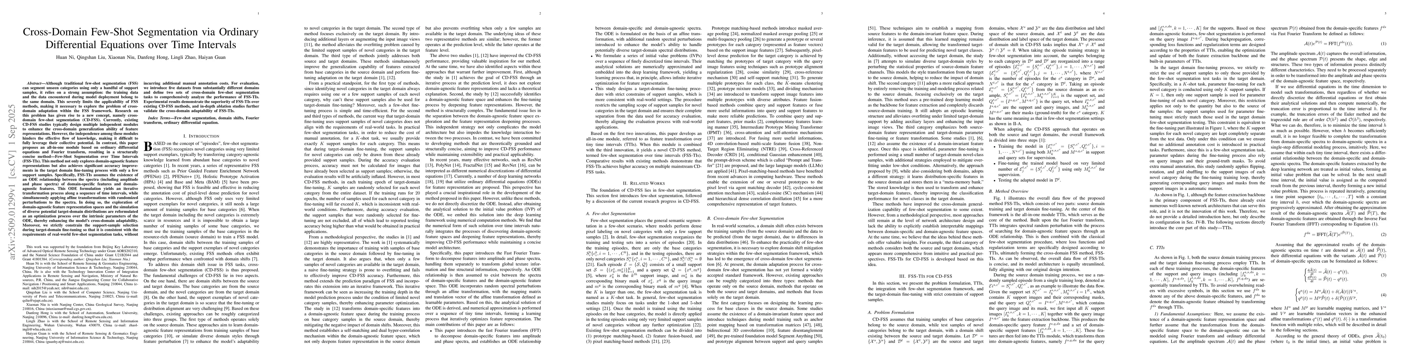
Cross-domain few-shot segmentation (CD-FSS) not only enables the segmentation of unseen categories with very limited samples, but also improves cross-domain generalization ability within the few-shot ...
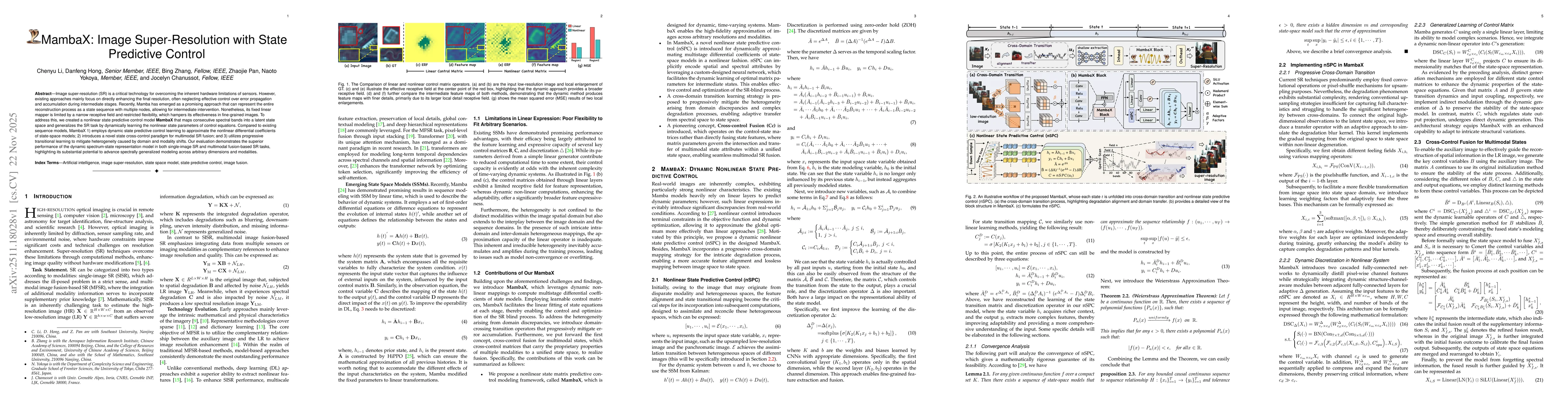
Image super-resolution (SR) is a critical technology for overcoming the inherent hardware limitations of sensors. However, existing approaches mainly focus on directly enhancing the final resolution, ...
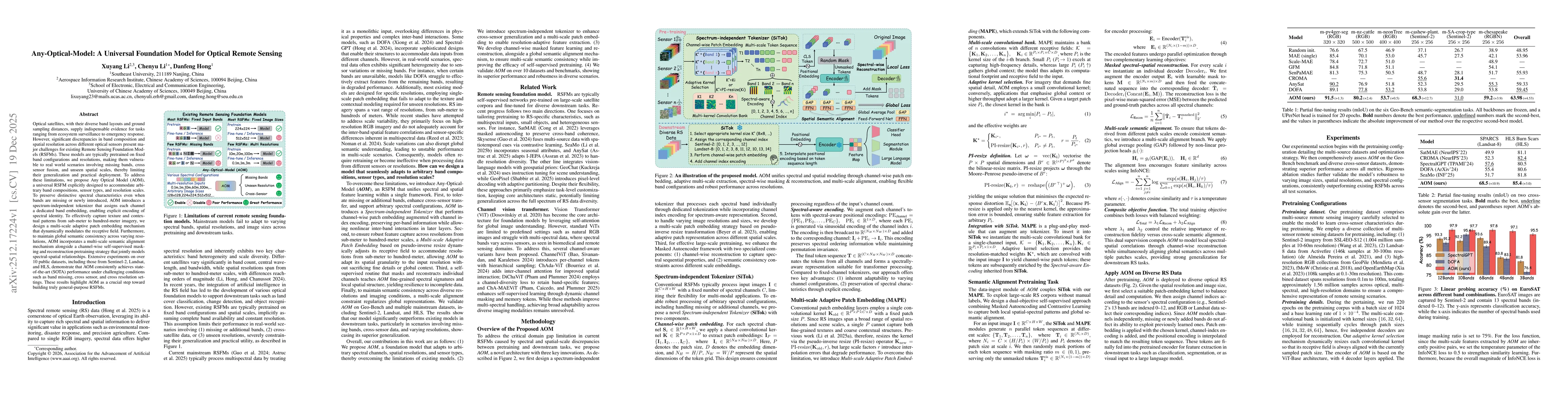
Optical satellites, with their diverse band layouts and ground sampling distances, supply indispensable evidence for tasks ranging from ecosystem surveillance to emergency response. However, significa...
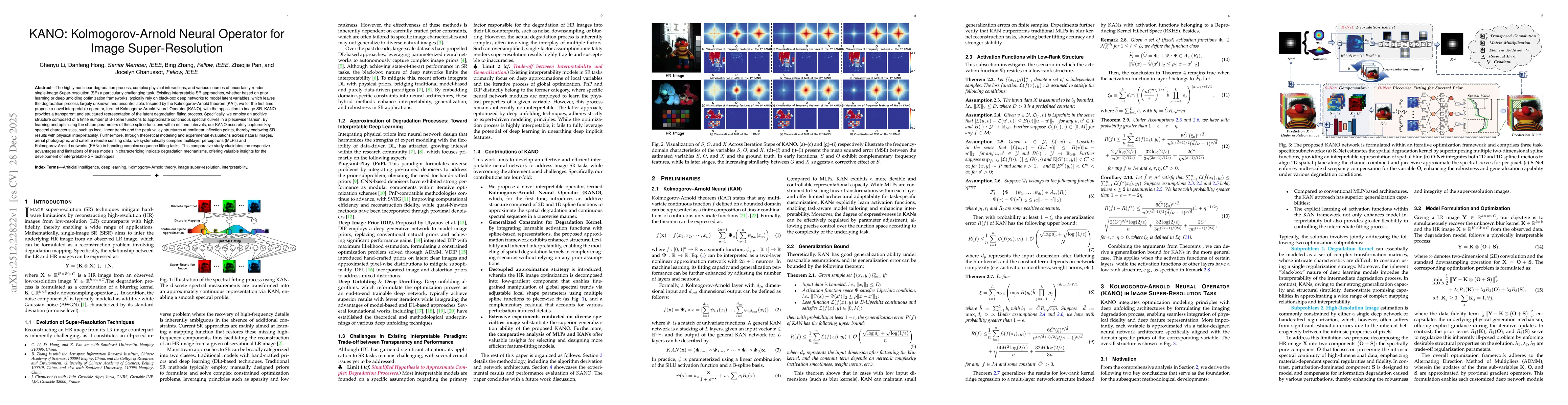
The highly nonlinear degradation process, complex physical interactions, and various sources of uncertainty render single-image Super-resolution (SR) a particularly challenging task. Existing interpre...
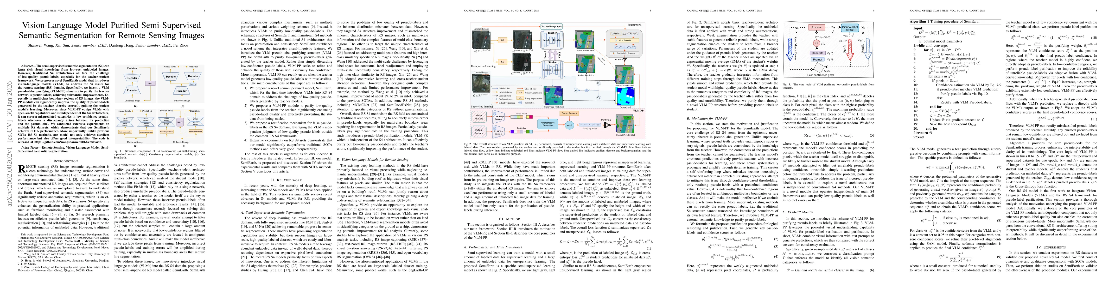
The semi-supervised semantic segmentation (S4) can learn rich visual knowledge from low-cost unlabeled images. However, traditional S4 architectures all face the challenge of low-quality pseudo-labels...
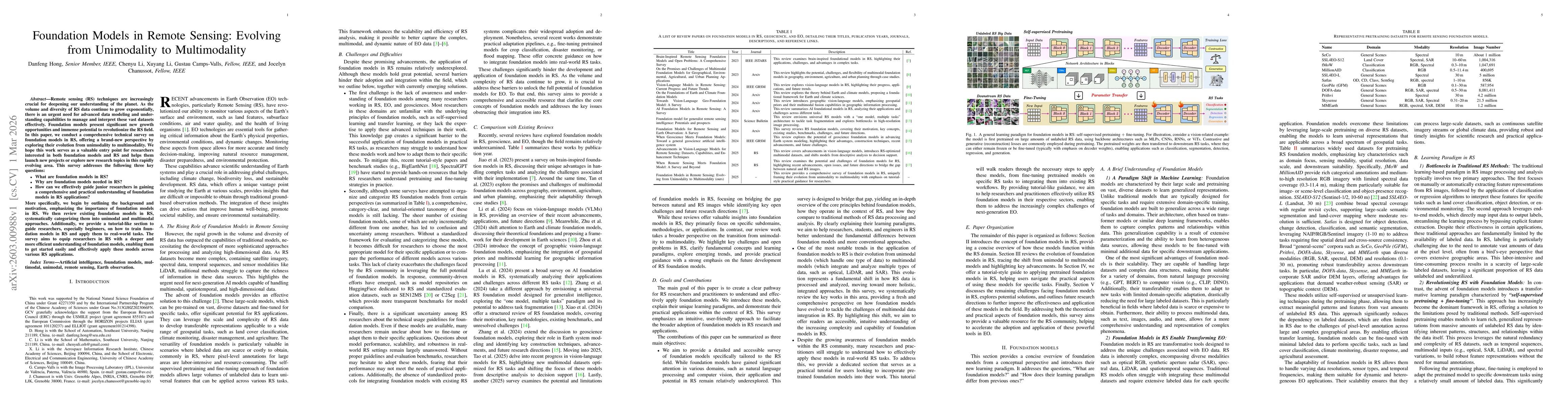
Remote sensing (RS) techniques are increasingly crucial for deepening our understanding of the planet. As the volume and diversity of RS data continue to grow exponentially, there is an urgent need fo...
Living in a changing climate, human society now faces more frequent and severe natural disasters than ever before. As a consequence, rapid disaster response during the "Golden 72 Hours" of search and ...