Academic Profile
Statistics
Similar Authors
Papers on arXiv
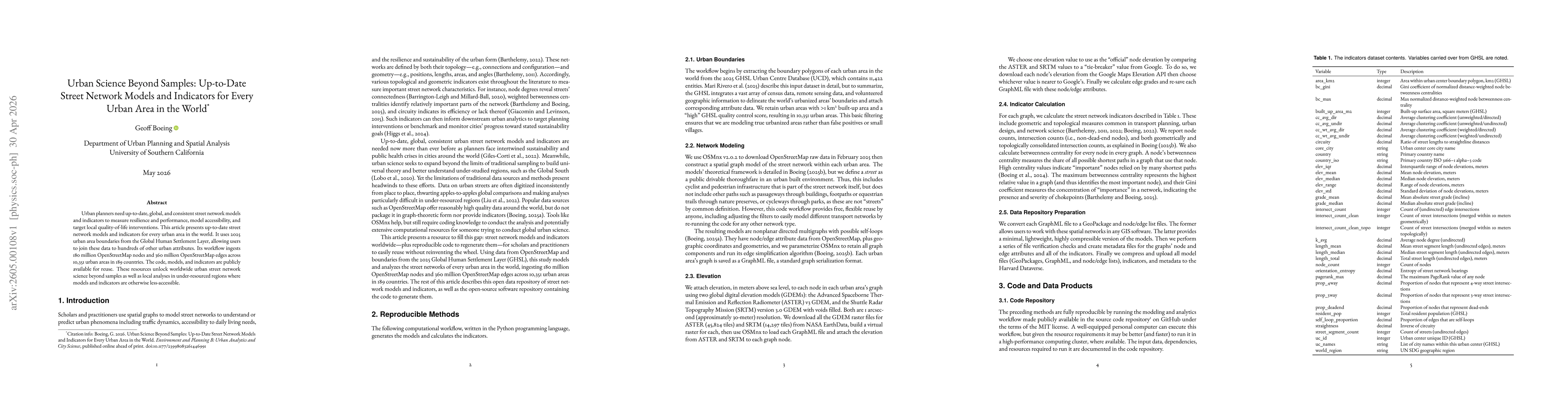
Street intersection counts and densities are ubiquitous measures in transport geography and planning. However, typical street network data and typical street network analysis tools can substantially...
Street networks allow people and goods to move through cities, but they are vulnerable to disasters like floods, earthquakes, and terrorist attacks. Well-planned network design can make a city more ...
This study estimates the relationships between street network characteristics and transport-sector CO2 emissions across every urban area in the world and investigates whether they are the same acros...
Vehicular air pollution has created an ongoing air quality and public health crisis. Despite growing knowledge of racial injustice in exposure levels, less is known about the relationship between th...
Benchmarking and monitoring urban design and transport features is critical to achieving local and international health and sustainability goals. However, most urban indicator frameworks use coarse ...
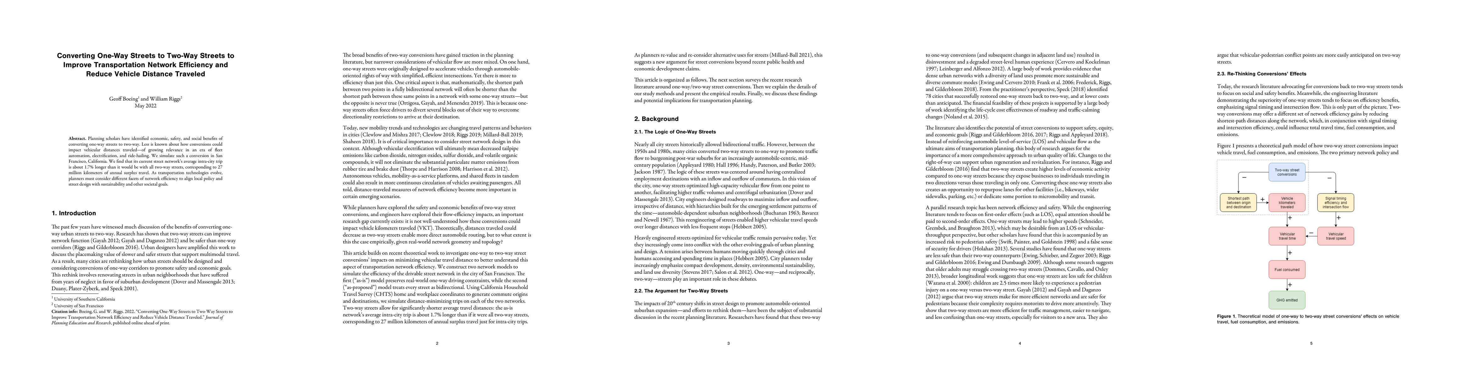
Planning scholars have identified economic, safety, and social benefits of converting one-way streets to two-way. Less is known about how conversions could impact vehicular distances traveled - of g...
This article interprets emerging scholarship on rental housing platforms -- particularly the most well-known and used short- and long-term rental housing platforms - and considers how the technologi...
Pedestrian accessibility is an important factor in urban transport and land use policy and critical for creating healthy, sustainable cities. Developing and evaluating indicators measuring inequalit...
Urban analytics combines spatial analysis, statistics, computer science, and urban planning to understand and shape city futures. While it promises better policymaking insights, concerns exist aroun...
In 1974, Robert Caro published The Power Broker, a critical biography of Robert Moses's dictatorial tenure as the "master builder" of mid-century New York. Moses profoundly transformed New York's ur...
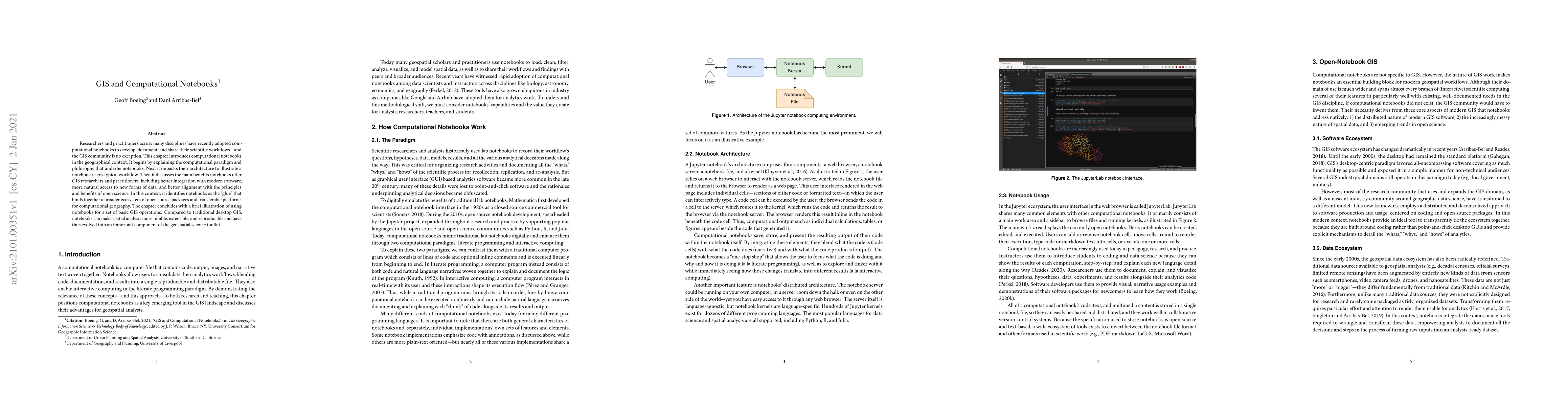
Researchers and practitioners across many disciplines have recently adopted computational notebooks to develop, document, and share their scientific workflows - and the GIS community is no exception...
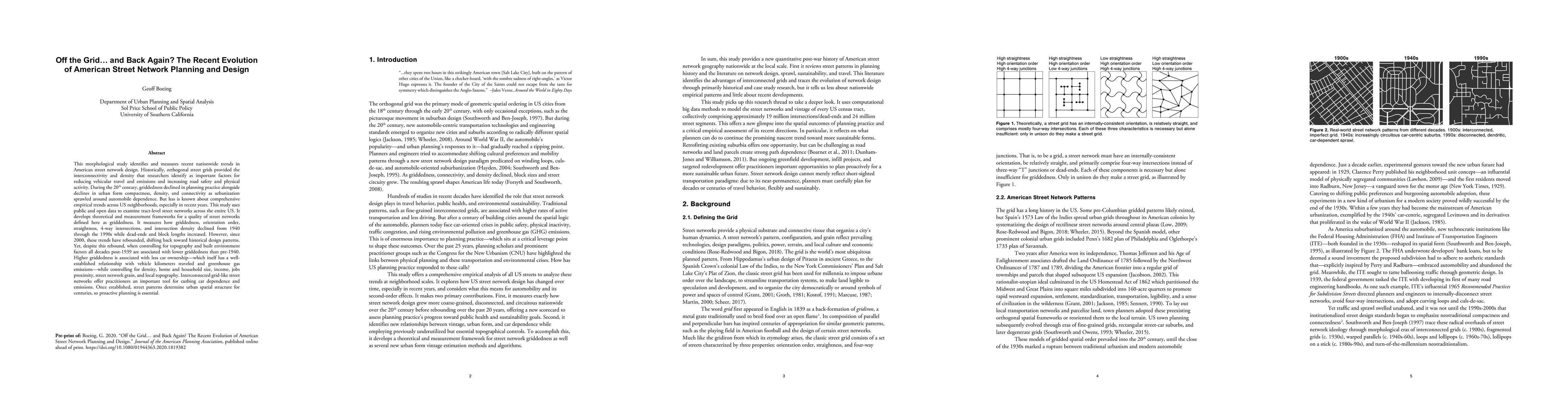
This morphological study identifies and measures recent nationwide trends in American street network design. Historically, orthogonal street grids provided the interconnectivity and density that res...
Cities worldwide exhibit a variety of street network patterns and configurations that shape human mobility, equity, health, and livelihoods. This study models and analyzes the street networks of eve...
This chapter introduces OpenStreetMap - a crowd-sourced, worldwide mapping project and geospatial data repository - to illustrate its usefulness in quickly and easily analyzing and visualizing plann...
This paper was presented as the 8th annual Transactions in GIS plenary address at the American Association of Geographers annual meeting in Washington, DC. The spatial sciences have recently seen gr...
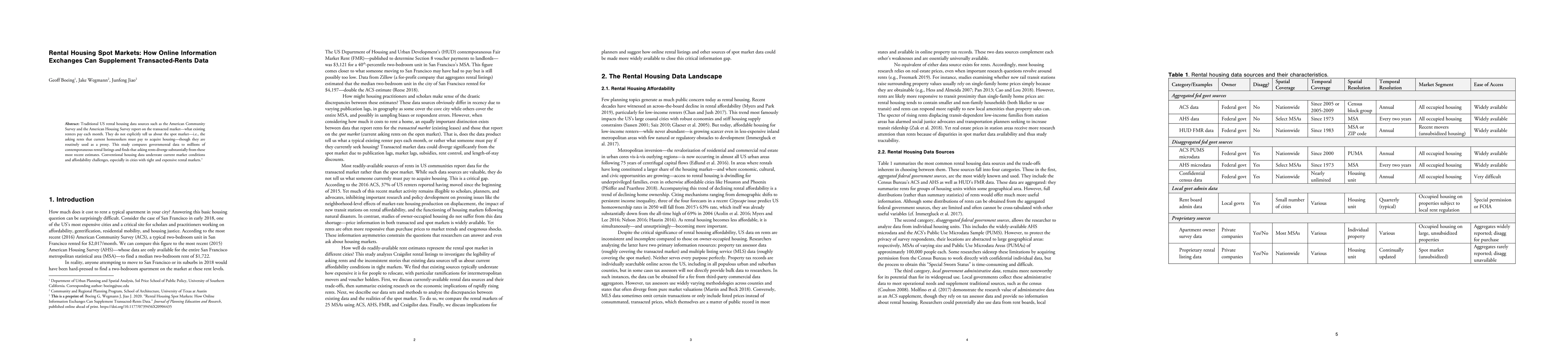
Traditional US rental housing data sources such as the American Community Survey and the American Housing Survey report on the transacted market - what existing renters pay each month. They do not e...
Housing scholars stress the importance of the information environment in shaping housing search behavior and outcomes. Rental listings have increasingly moved online over the past two decades and, i...
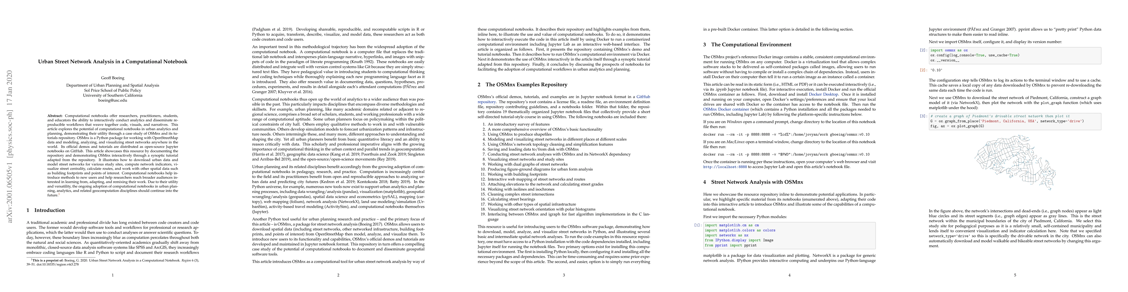
Computational notebooks offer researchers, practitioners, students, and educators the ability to interactively conduct analytics and disseminate reproducible workflows that weave together code, visu...
Urban planning and morphology have relied on analytical cartography and visual communication tools for centuries to illustrate spatial patterns, propose designs, compare alternatives, and engage the...
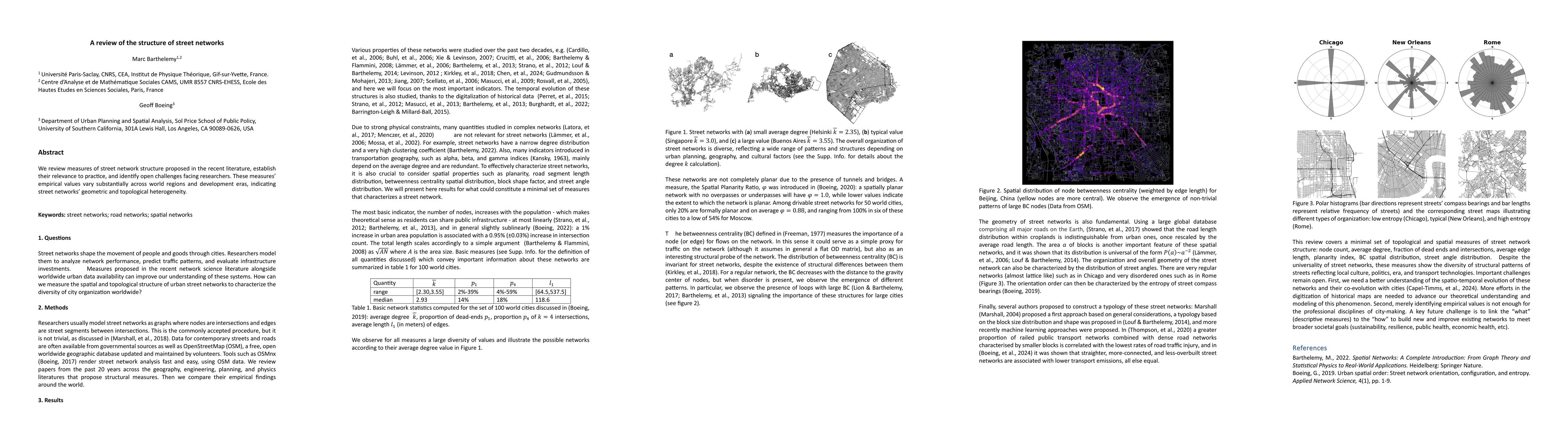
We review measures of street network structure proposed in the recent literature, establish their relevance to practice, and identify open challenges facing researchers. These measures' empirical valu...
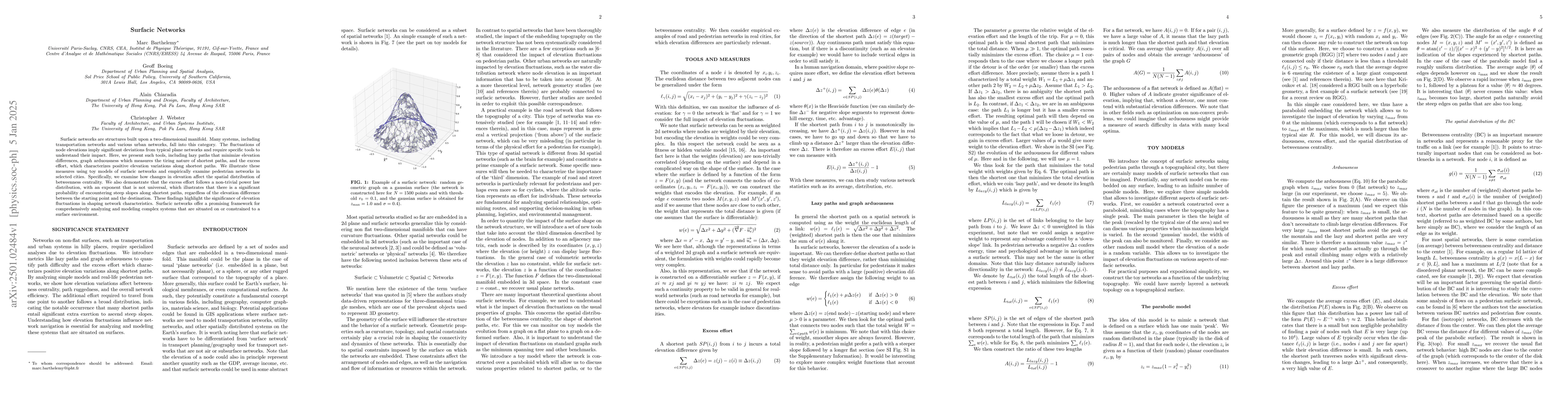
Surfacic networks are structures built upon a two-dimensional manifold. Many systems, including transportation networks and various urban networks, fall into this category. The fluctuations of node el...
OSMnx is a Python package for downloading, modeling, analyzing, and visualizing urban networks and any other geospatial features from OpenStreetMap data. A large and growing body of literature uses it...
Analyzing 9,000 urban areas' street networks, we identify properties, including extreme betweenness centrality heterogeneity, that typical spatial network models fail to explain. Accordingly we propos...
Travel time prediction is central to transport geography and planning's accessibility analyses, sustainable transportation infrastructure provision, and active transportation interventions. However, c...
Urban planners need up-to-date, global, and consistent street network models and indicators to measure resilience and performance, model accessibility, and target local quality-of-life interventions. ...