Gilda Schirinzi

5 papers on arXiv

Academic Profile

Name: Gilda Schirinzi
Total Papers: 229

Statistics

arXiv Papers 5
Total Publications 229

Papers on arXiv

Thumbnail for AI techniques for near real-time monitoring of contaminants in coastal
  waters on board future Phisat-2 mission

AI techniques for near real-time monitoring of contaminants in coastal waters on board future Phisat-2 mission

Differently from conventional procedures, the proposed solution advocates for a groundbreaking paradigm in water quality monitoring through the integration of satellite Remote Sensing (RS) data, Art...

Thumbnail for CATSNet: a context-aware network for Height Estimation in a Forested
  Area based on Pol-TomoSAR data

CATSNet: a context-aware network for Height Estimation in a Forested Area based on Pol-TomoSAR data

Tropical forests are a key component of the global carbon cycle. With plans for upcoming space-borne missions like BIOMASS to monitor forestry, several airborne missions, including TropiSAR and Afri...

Thumbnail for Monitoring water contaminants in coastal areas through ML algorithms
  leveraging atmospherically corrected Sentinel-2 data

Monitoring water contaminants in coastal areas through ML algorithms leveraging atmospherically corrected Sentinel-2 data

Monitoring water contaminants is of paramount importance, ensuring public health and environmental well-being. Turbidity, a key parameter, poses a significant problem, affecting water quality. Its a...

Thumbnail for Assessment of Spectral based Solutions for the Detection of Floating
  Marine Debris

Assessment of Spectral based Solutions for the Detection of Floating Marine Debris

Typically, the detection of marine debris relies on in-situ campaigns that are characterized by huge human effort and limited spatial coverage. Following the need of a rapid solution for the detection...

Thumbnail for An Efficient Machine Learning Framework for Forest Height Estimation
  from Multi-Polarimetric Multi-Baseline SAR data

An Efficient Machine Learning Framework for Forest Height Estimation from Multi-Polarimetric Multi-Baseline SAR data

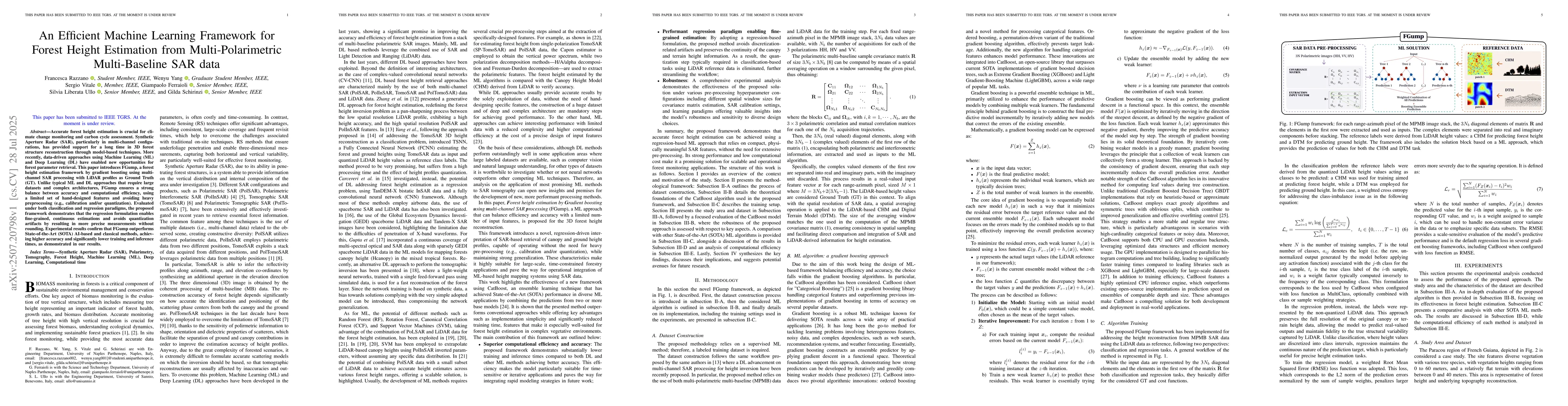
Accurate forest height estimation is crucial for climate change monitoring and carbon cycle assessment. Synthetic Aperture Radar (SAR), particularly in multi-channel configurations, has provided suppo...

This website uses cookies to ensure you get the best experience. Learn more