Academic Profile
Statistics
Similar Authors
Papers on arXiv
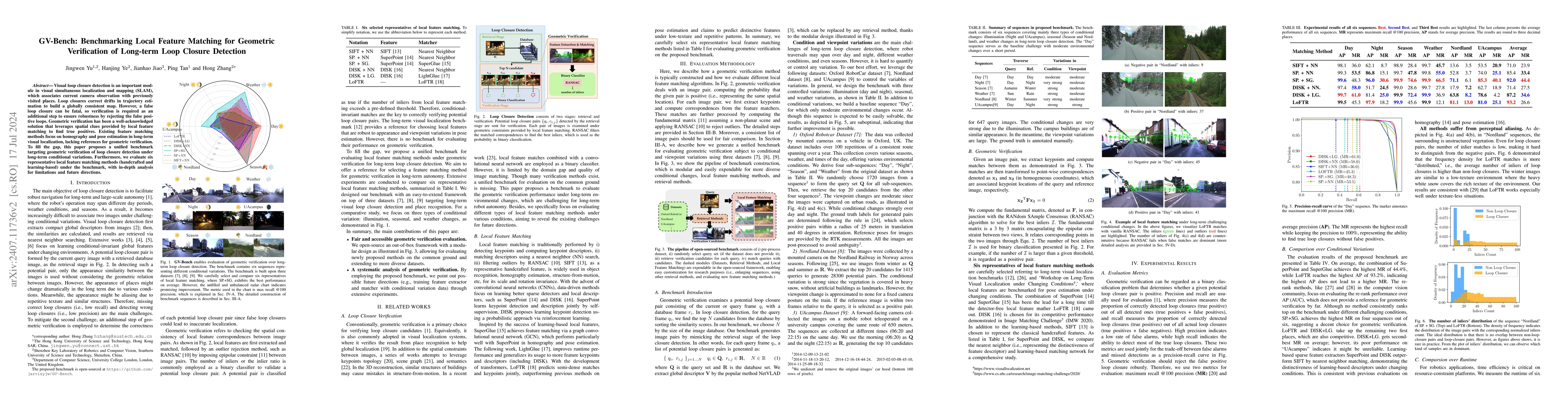
Visual loop closure detection is an important module in visual simultaneous localization and mapping (SLAM), which associates current camera observation with previously visited places. Loop closures c...
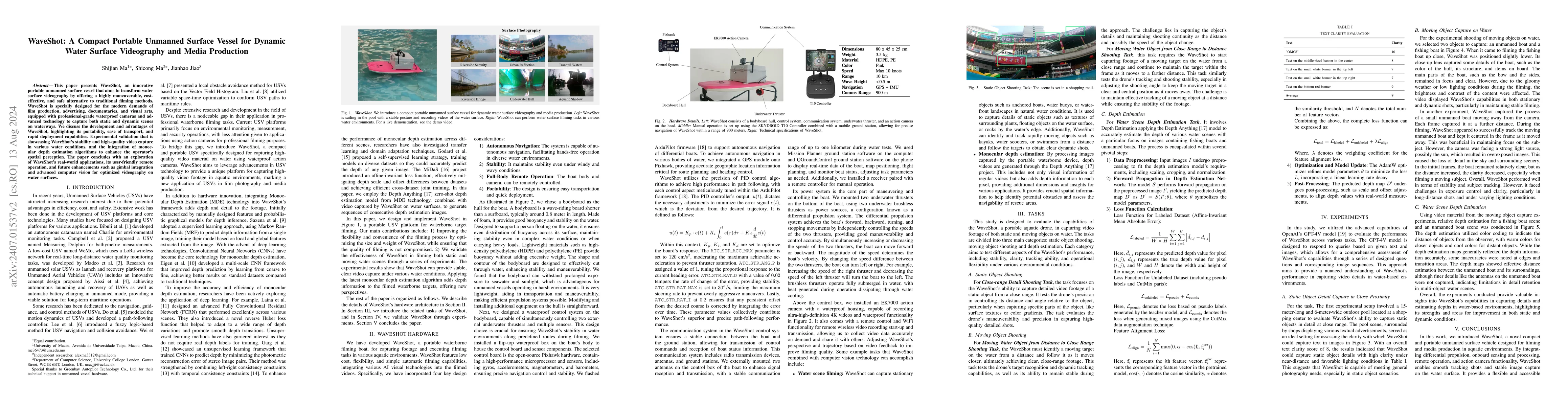
This paper presents WaveShot, an innovative portable unmanned surface vessel that aims to transform water surface videography by offering a highly maneuverable, cost-effective, and safe alternative ...
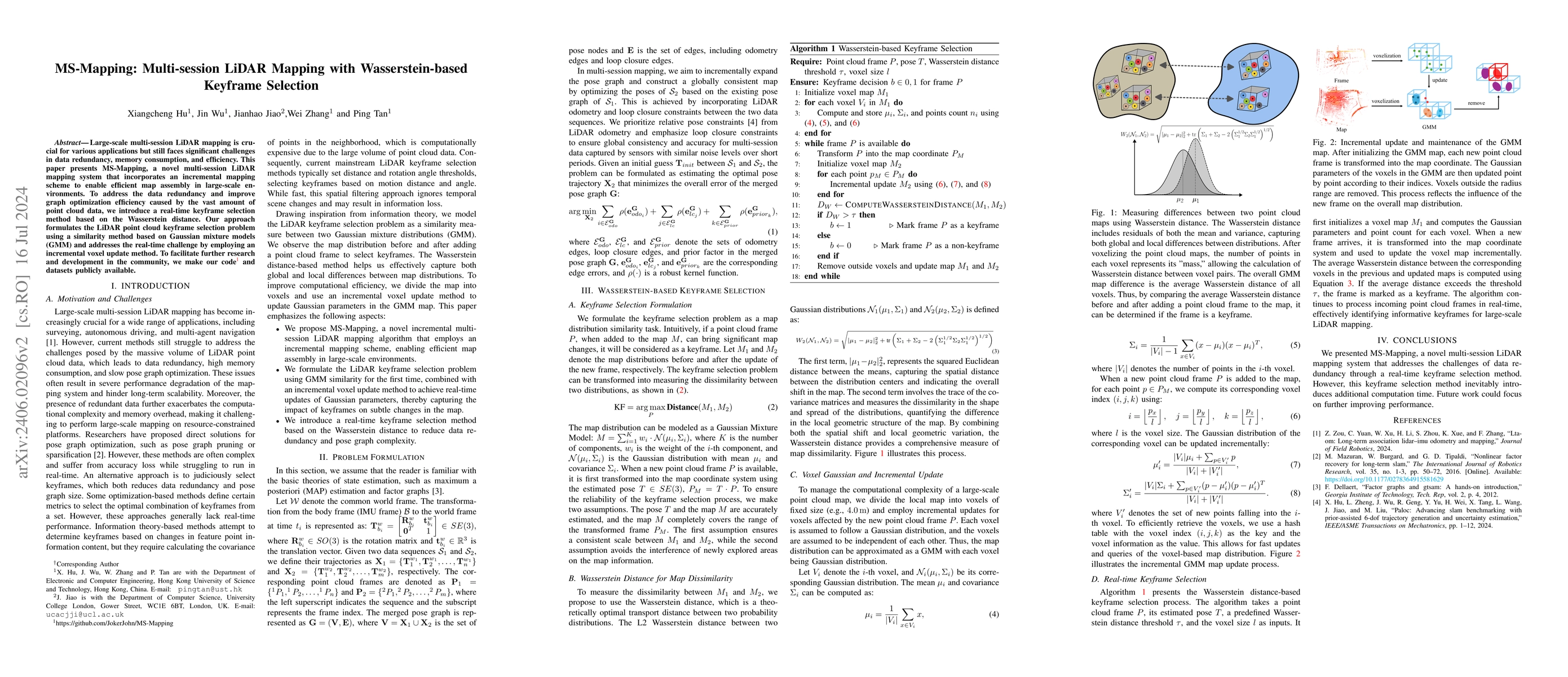
Large-scale multi-session LiDAR mapping plays a crucial role in various applications but faces significant challenges in data redundancy and pose graph scalability. This paper present MS-Mapping, a ...
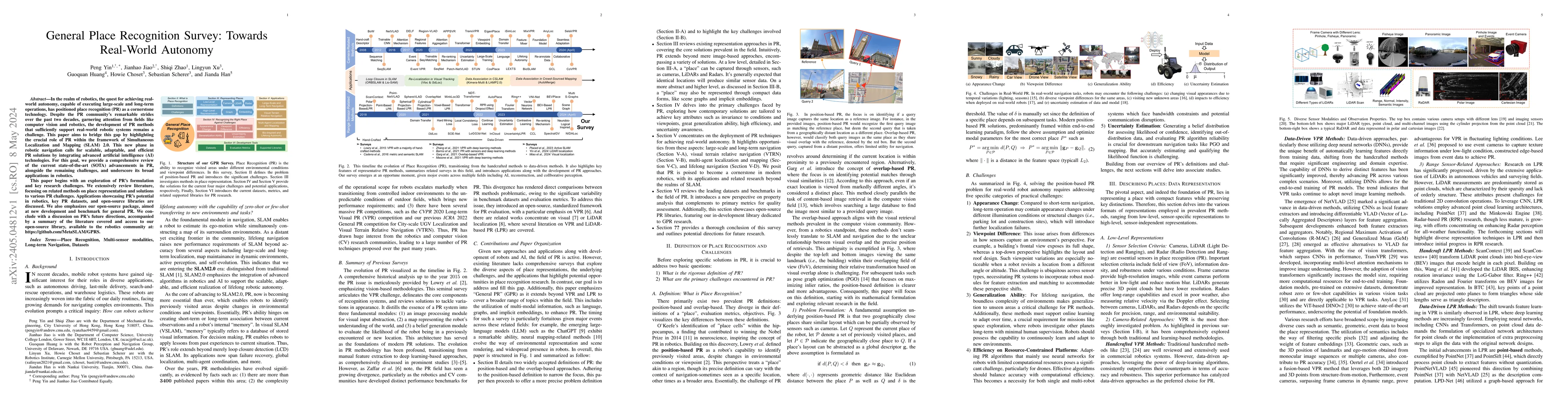
In the realm of robotics, the quest for achieving real-world autonomy, capable of executing large-scale and long-term operations, has positioned place recognition (PR) as a cornerstone technology. D...
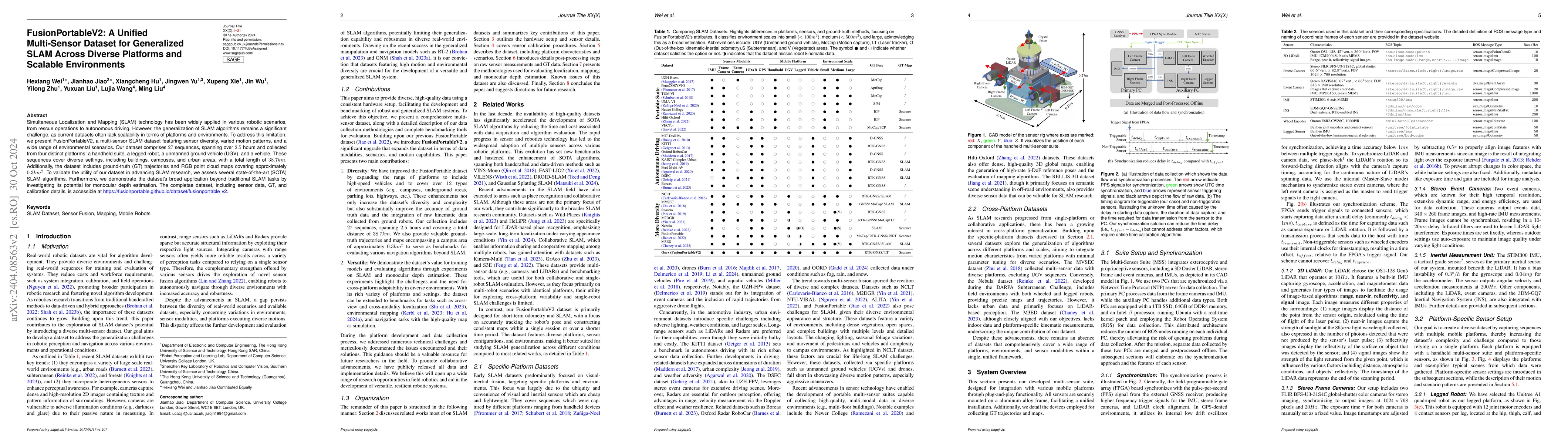
Simultaneous Localization and Mapping (SLAM) technology has been widely applied in various robotic scenarios, from rescue operations to autonomous driving. However, the generalization of SLAM algori...
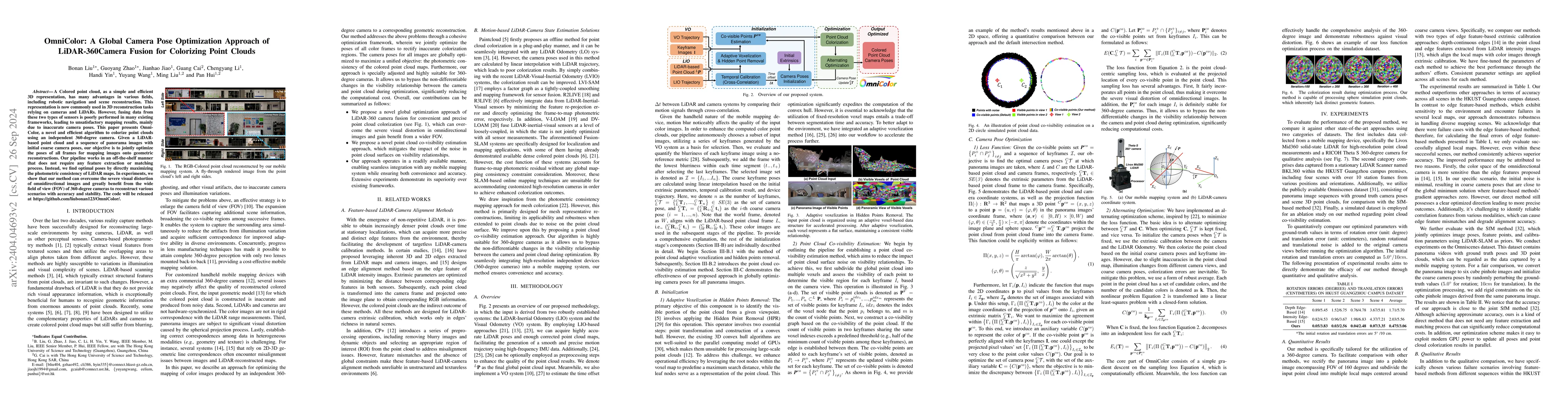
A Colored point cloud, as a simple and efficient 3D representation, has many advantages in various fields, including robotic navigation and scene reconstruction. This representation is now commonly ...
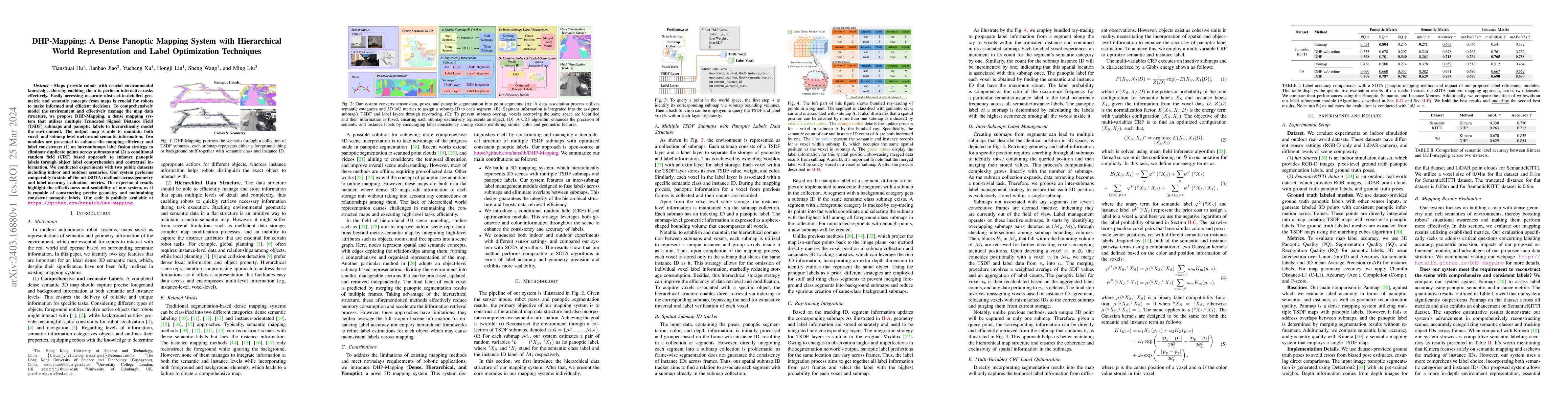
Maps provide robots with crucial environmental knowledge, thereby enabling them to perform interactive tasks effectively. Easily accessing accurate abstract-to-detailed geometric and semantic concep...
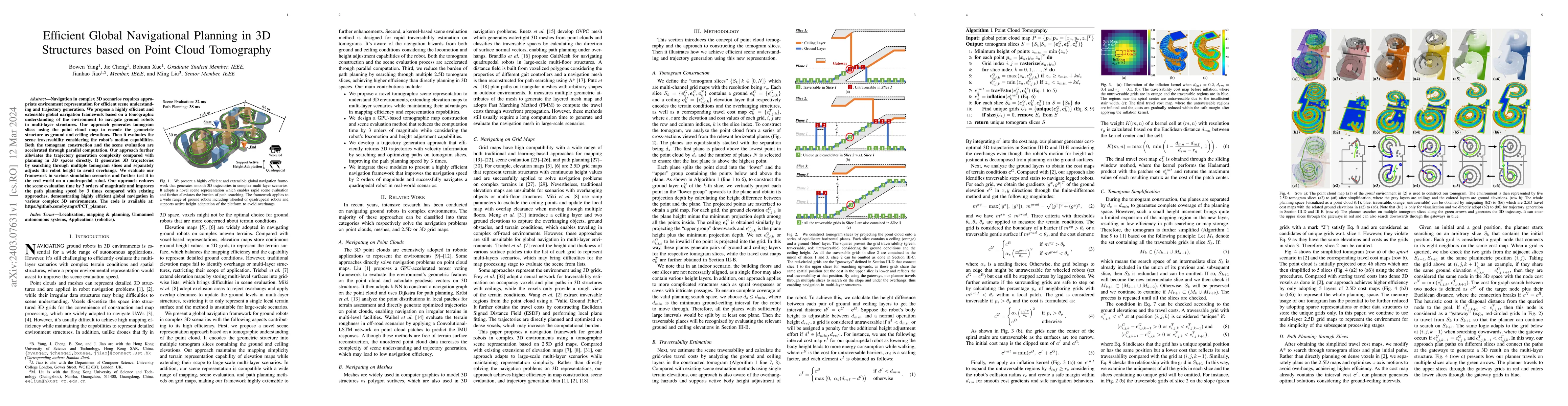
Navigation in complex 3D scenarios requires appropriate environment representation for efficient scene understanding and trajectory generation. We propose a highly efficient and extensible global na...
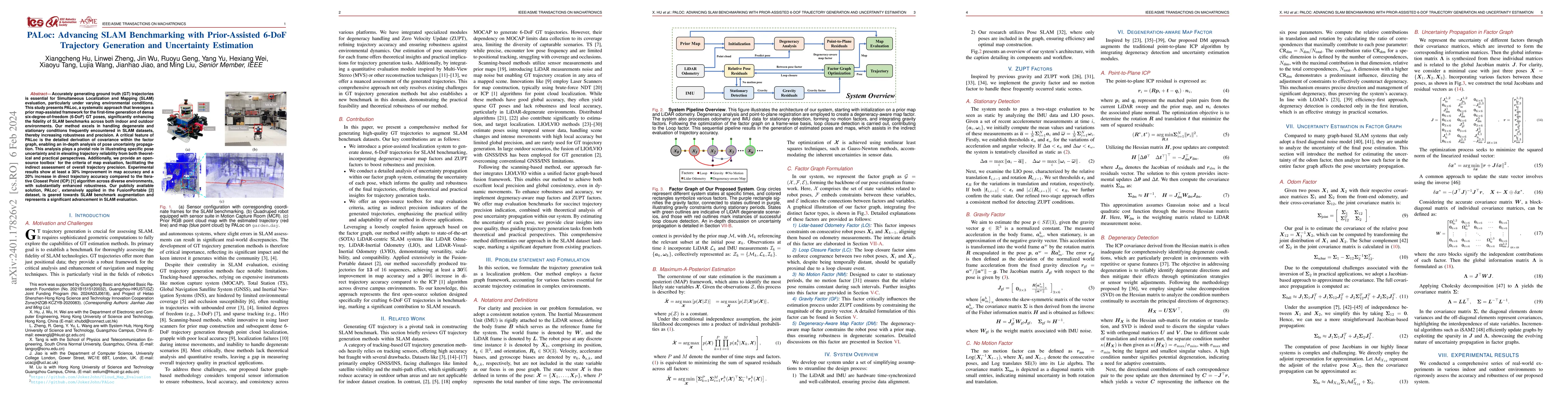
Accurately generating ground truth (GT) trajectories is essential for Simultaneous Localization and Mapping (SLAM) evaluation, particularly under varying environmental conditions. This study introdu...
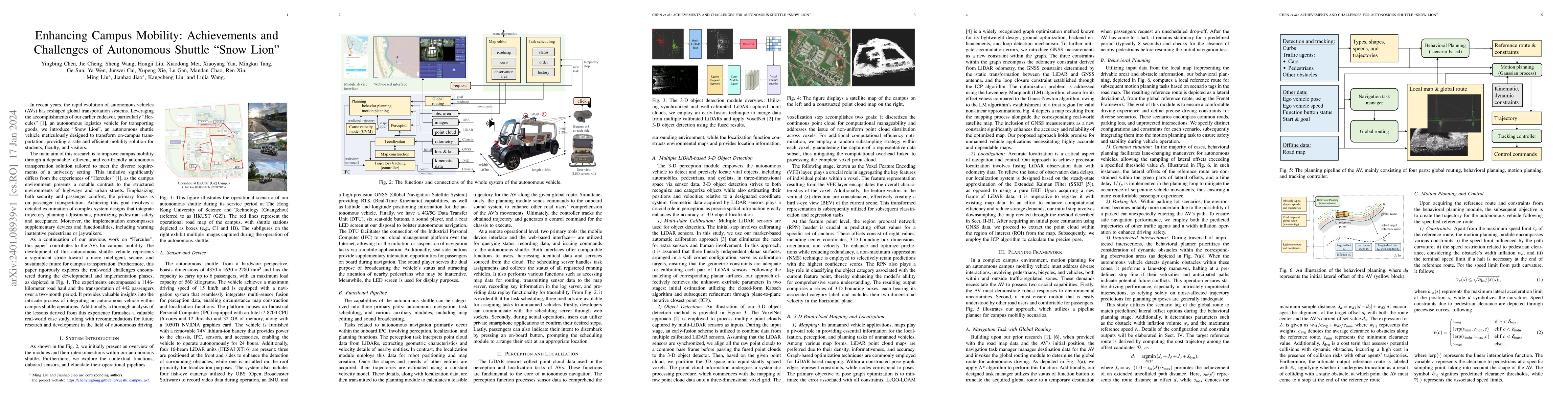
The rapid evolution of autonomous vehicles (AVs) has significantly influenced global transportation systems. In this context, we present ``Snow Lion'', an autonomous shuttle meticulously designed to...
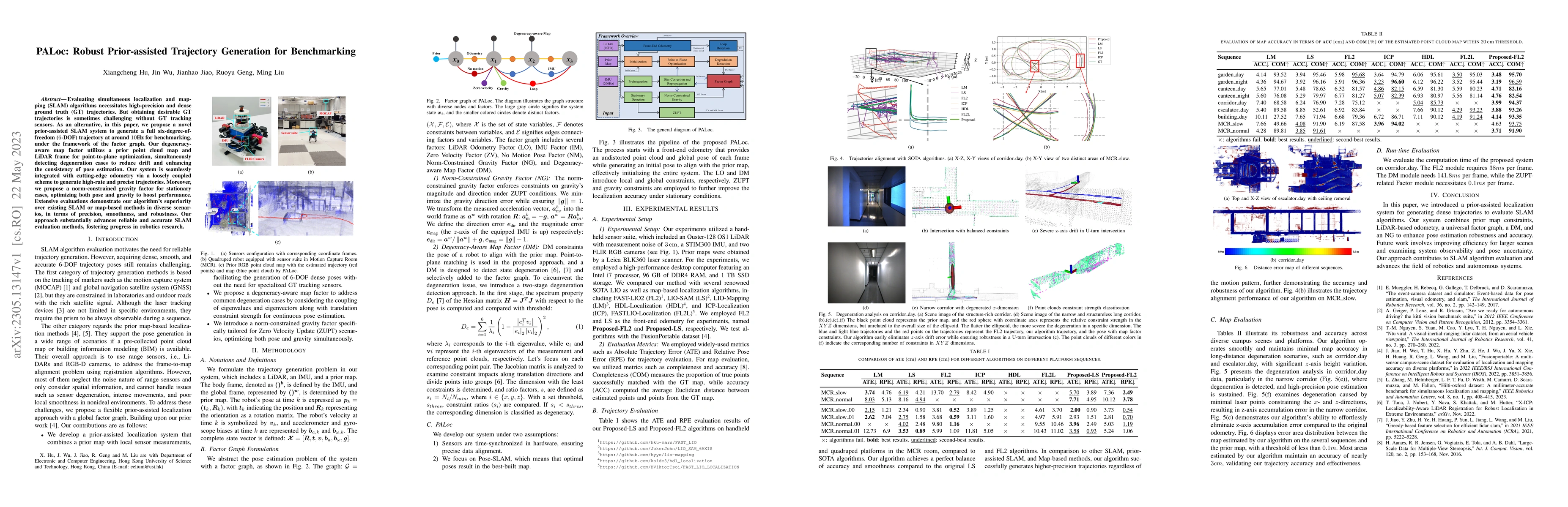
Evaluating simultaneous localization and mapping (SLAM) algorithms necessitates high-precision and dense ground truth (GT) trajectories. But obtaining desirable GT trajectories is sometimes challeng...
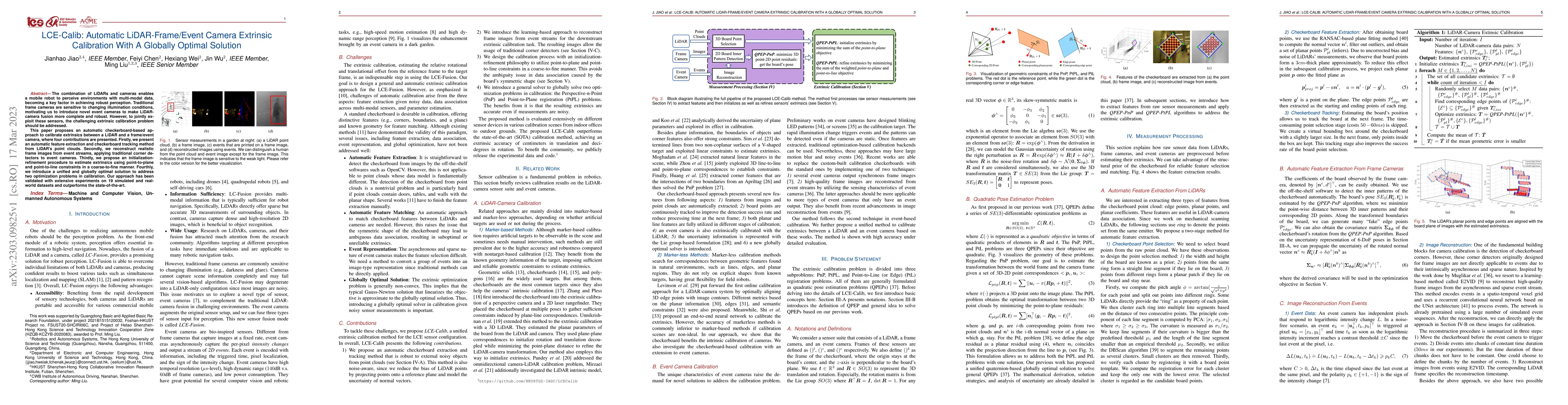
The combination of LiDARs and cameras enables a mobile robot to perceive environments with multi-modal data, becoming a key factor in achieving robust perception. Traditional frame cameras are sensi...
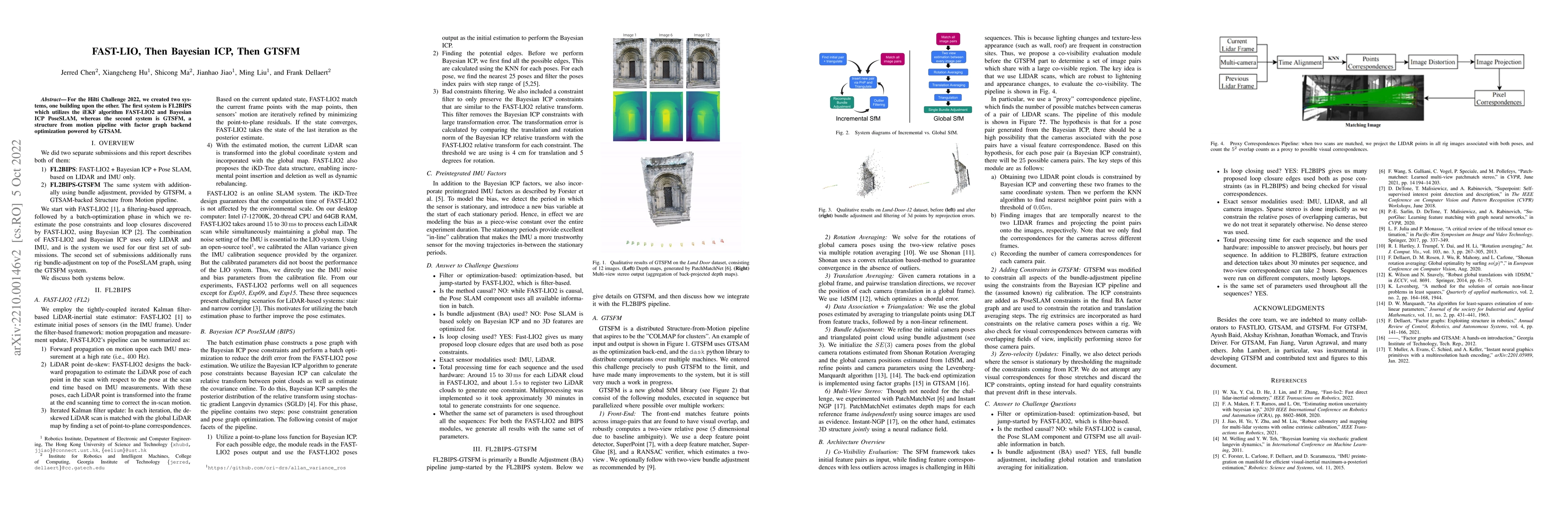
For the Hilti Challenge 2022, we created two systems, one building upon the other. The first system is FL2BIPS which utilizes the iEKF algorithm FAST-LIO2 and Bayesian ICP PoseSLAM, whereas the seco...
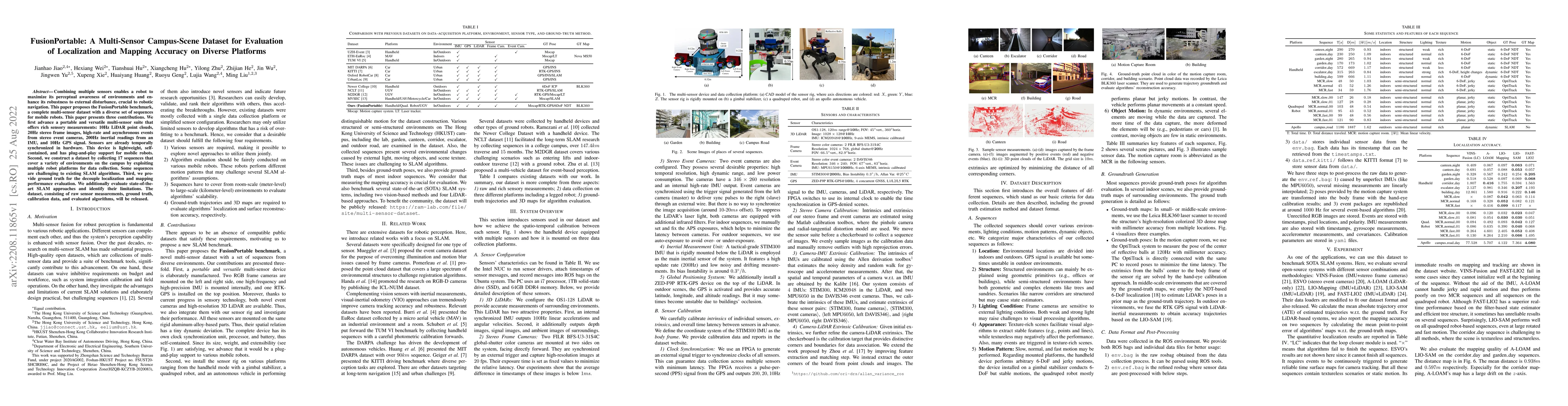
Combining multiple sensors enables a robot to maximize its perceptual awareness of environments and enhance its robustness to external disturbance, crucial to robotic navigation. This paper proposes...
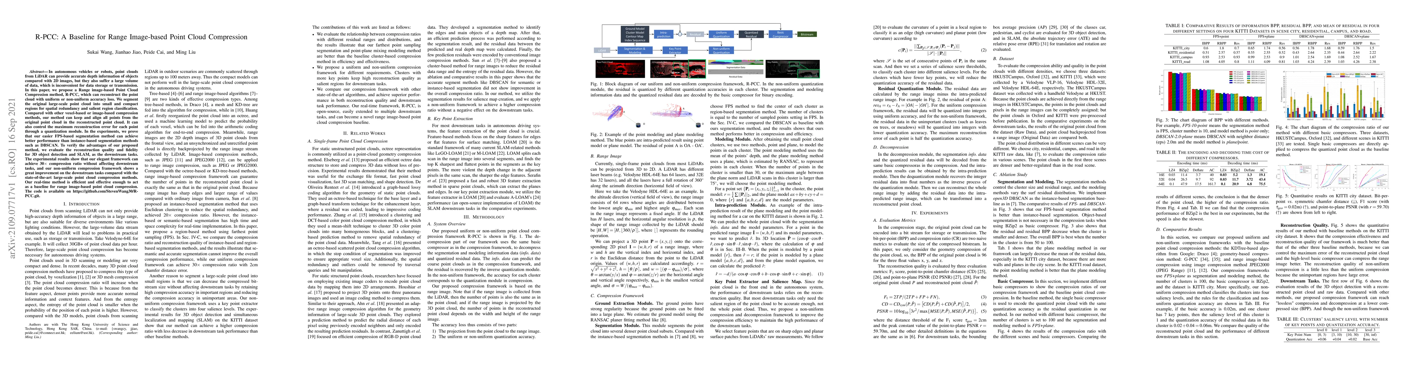
In autonomous vehicles or robots, point clouds from LiDAR can provide accurate depth information of objects compared with 2D images, but they also suffer a large volume of data, which is inconvenien...
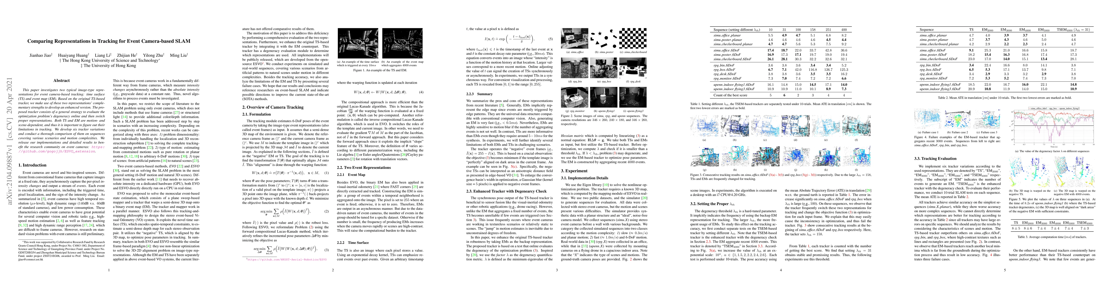
This paper investigates two typical image-type representations for event camera-based tracking: time surface (TS) and event map (EM). Based on the original TS-based tracker, we make use of these two...
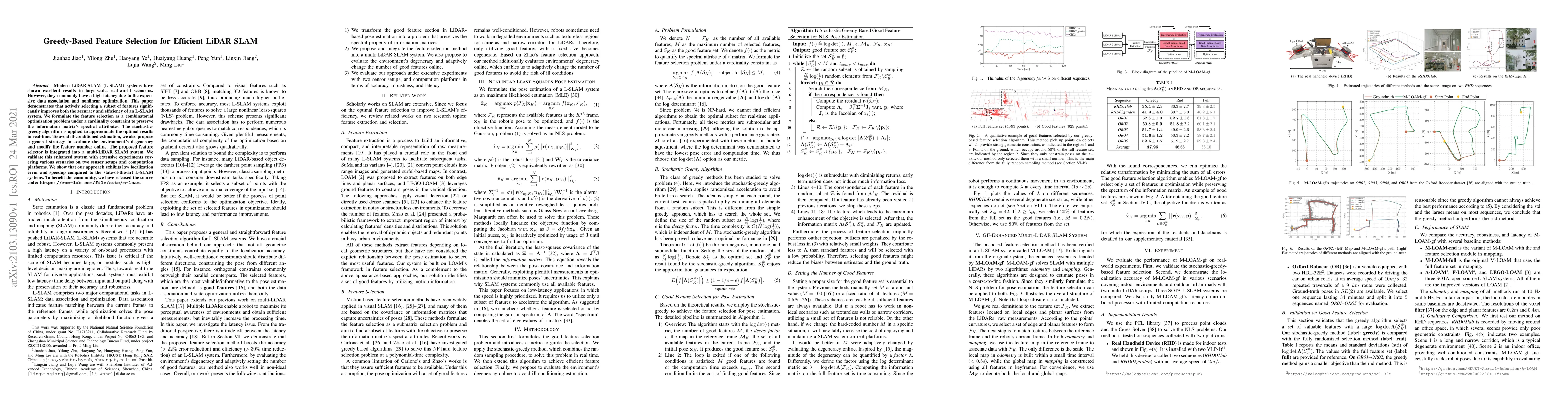
Modern LiDAR-SLAM (L-SLAM) systems have shown excellent results in large-scale, real-world scenarios. However, they commonly have a high latency due to the expensive data association and nonlinear o...
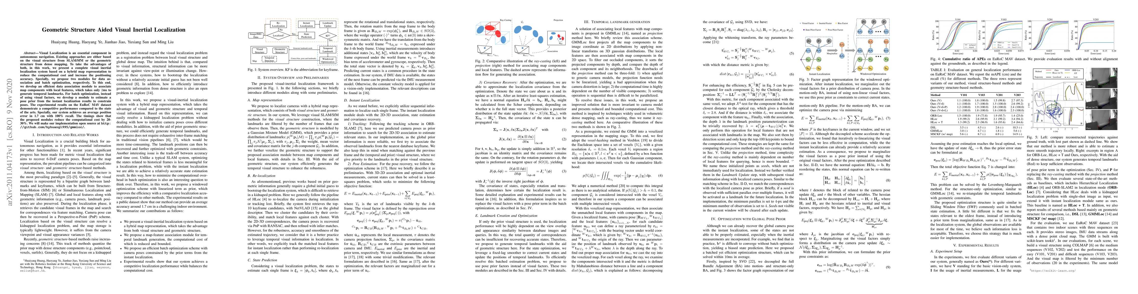
Visual Localization is an essential component in autonomous navigation. Existing approaches are either based on the visual structure from SLAM/SfM or the geometric structure from dense mapping. To t...
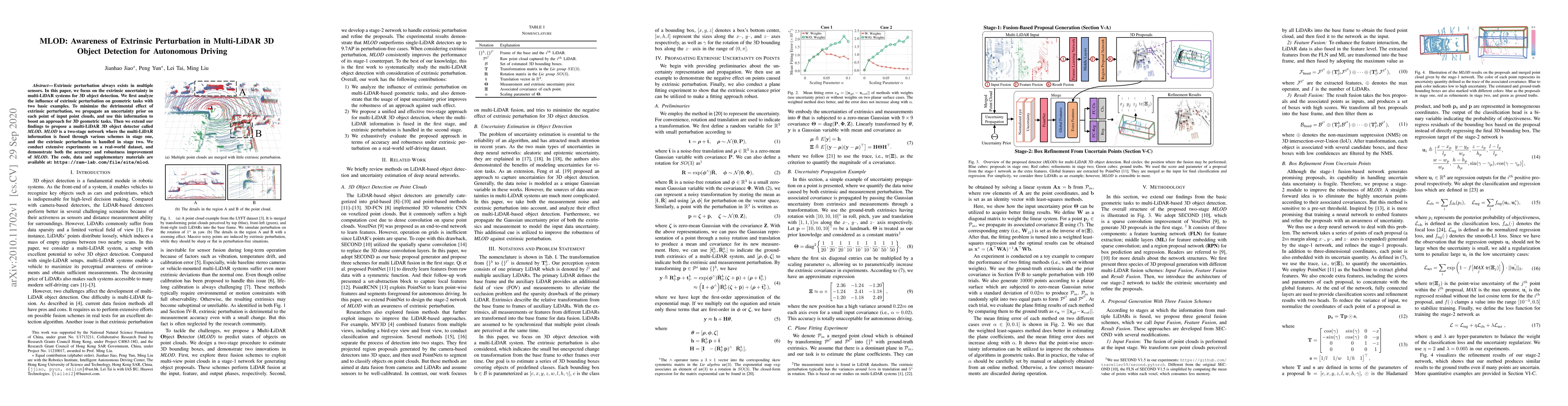
Extrinsic perturbation always exists in multiple sensors. In this paper, we focus on the extrinsic uncertainty in multi-LiDAR systems for 3D object detection. We first analyze the influence of extri...
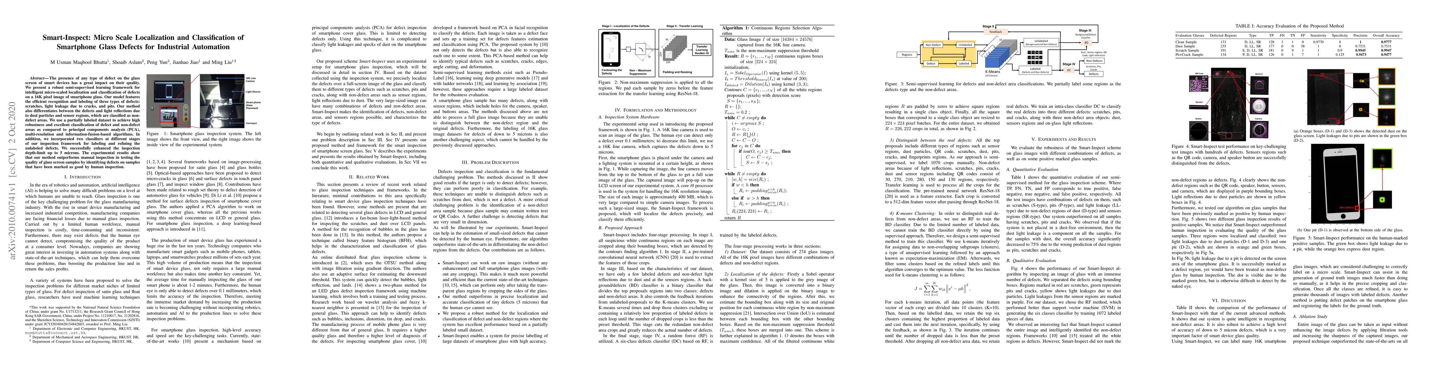
The presence of any type of defect on the glass screen of smart devices has a great impact on their quality. We present a robust semi-supervised learning framework for intelligent micro-scaled local...
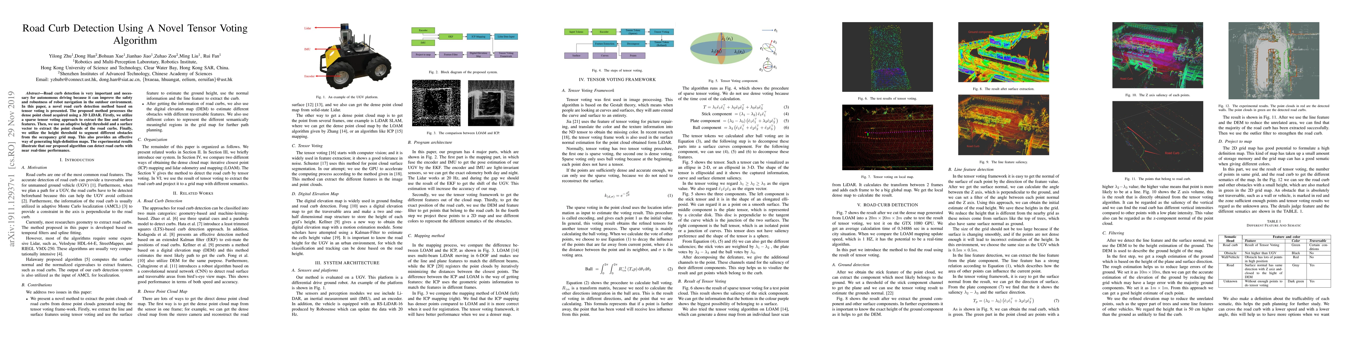
Road curb detection is very important and necessary for autonomous driving because it can improve the safety and robustness of robot navigation in the outdoor environment. In this paper, a novel roa...
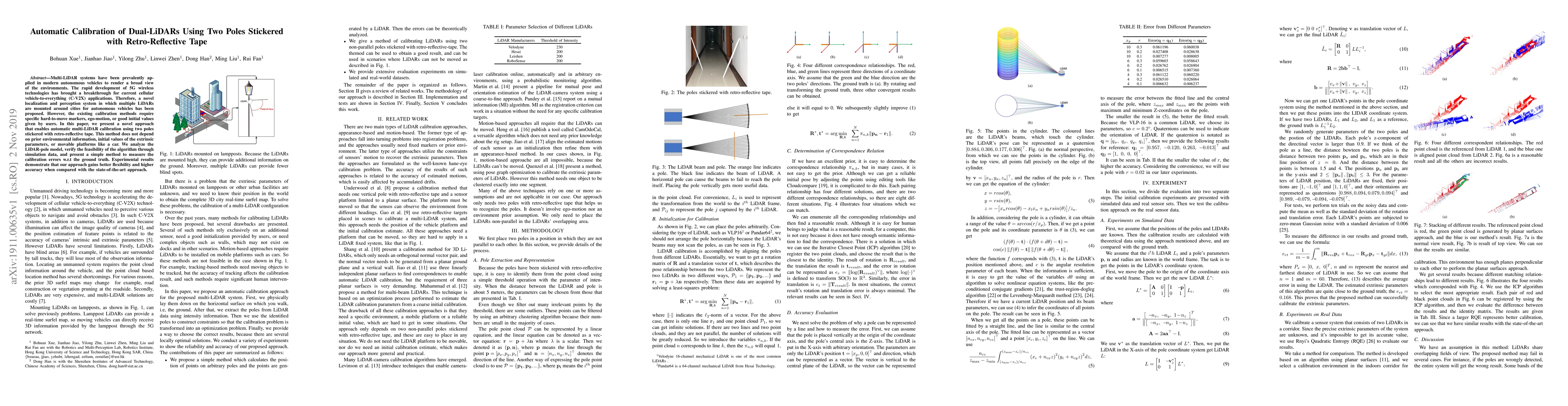
Multi-LiDAR systems have been prevalently applied in modern autonomous vehicles to render a broad view of the environments. The rapid development of 5G wireless technologies has brought a breakthrou...
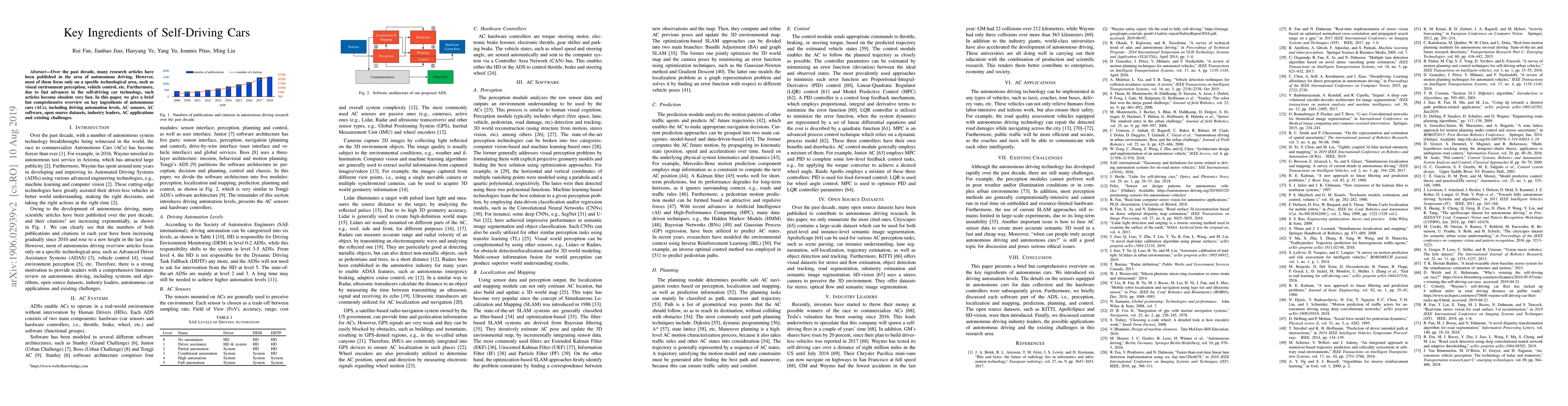
Over the past decade, many research articles have been published in the area of autonomous driving. However, most of them focus only on a specific technological area, such as visual environment perc...
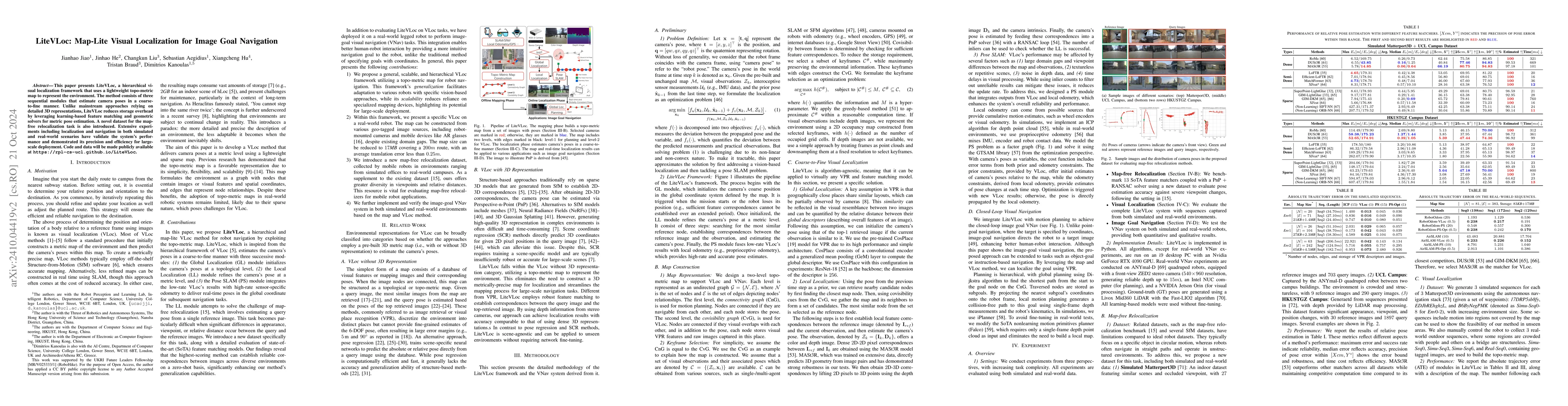
This paper presents LiteVLoc, a hierarchical visual localization framework that uses a lightweight topo-metric map to represent the environment. The method consists of three sequential modules that es...
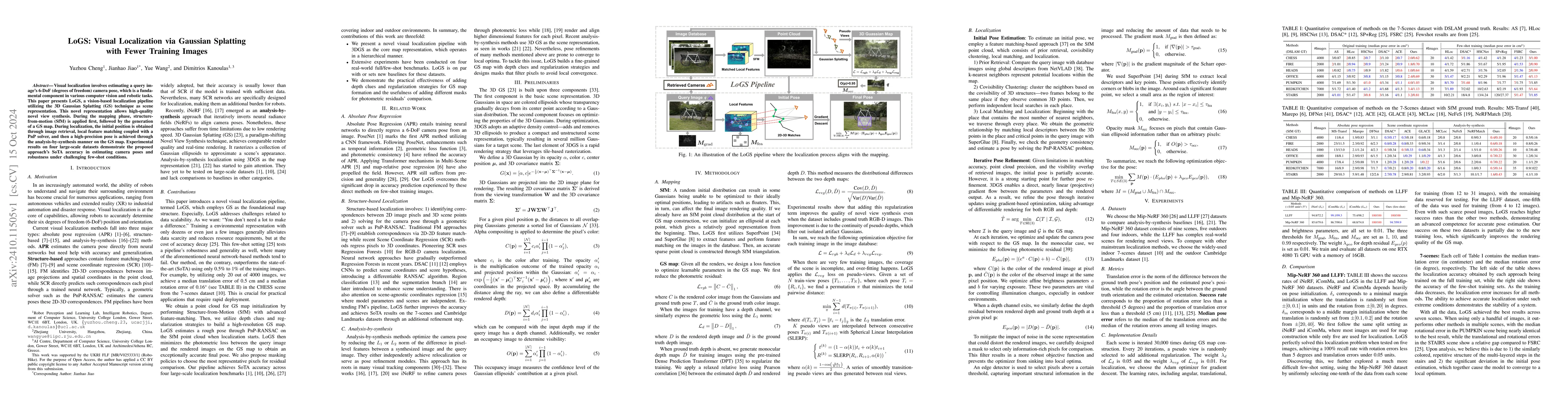
Visual localization involves estimating a query image's 6-DoF (degrees of freedom) camera pose, which is a fundamental component in various computer vision and robotic tasks. This paper presents LoGS,...
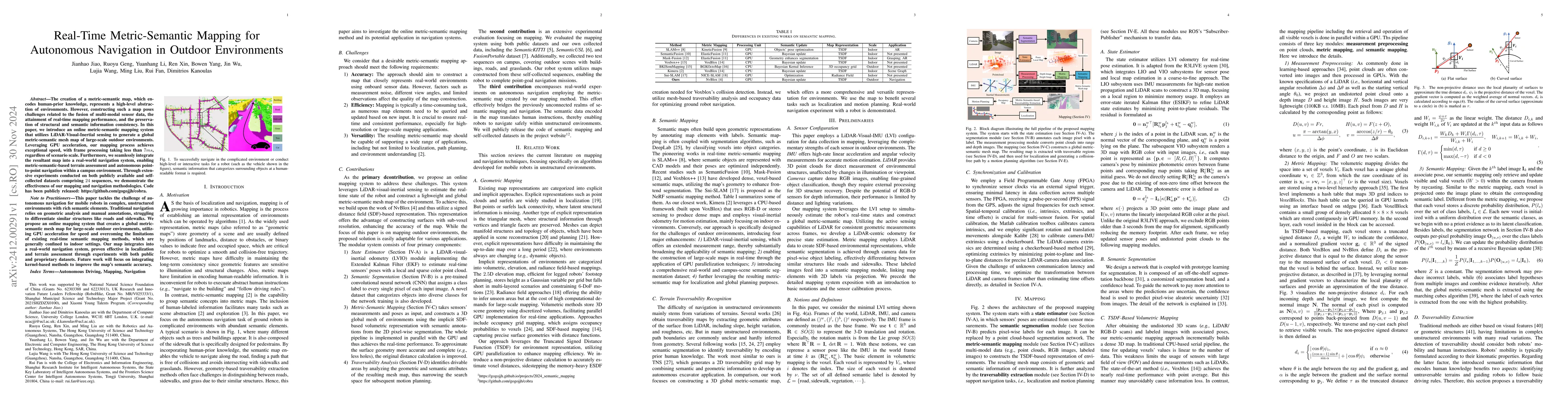
The creation of a metric-semantic map, which encodes human-prior knowledge, represents a high-level abstraction of environments. However, constructing such a map poses challenges related to the fusion...
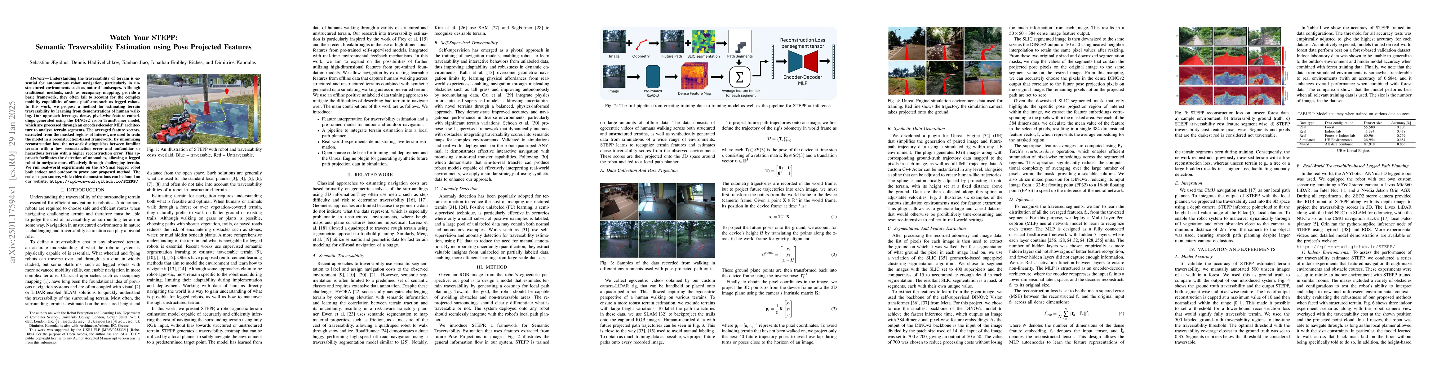
Understanding the traversability of terrain is essential for autonomous robot navigation, particularly in unstructured environments such as natural landscapes. Although traditional methods, such as oc...
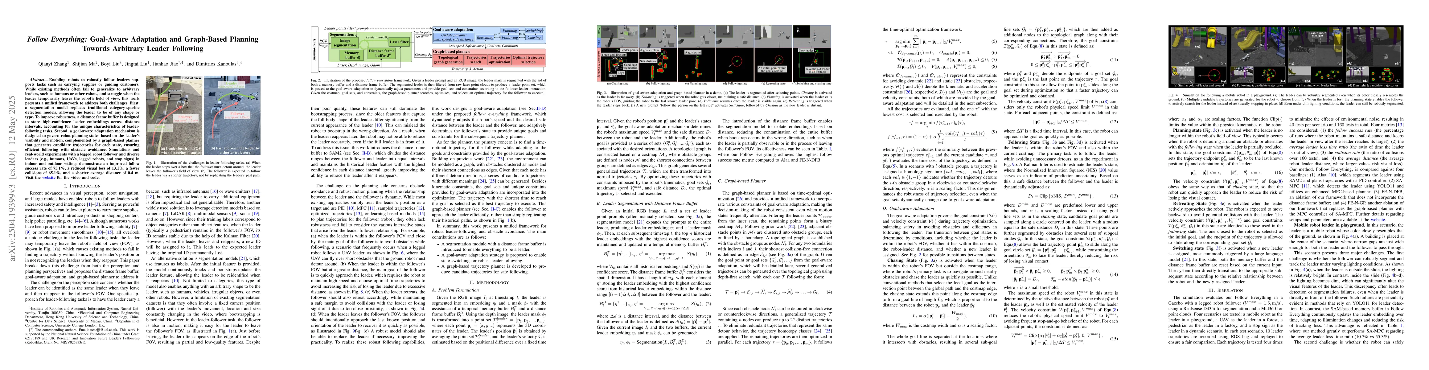
Robust and flexible leader-following is a critical capability for robots to integrate into human society. While existing methods struggle to generalize to leaders of arbitrary form and often fail when...
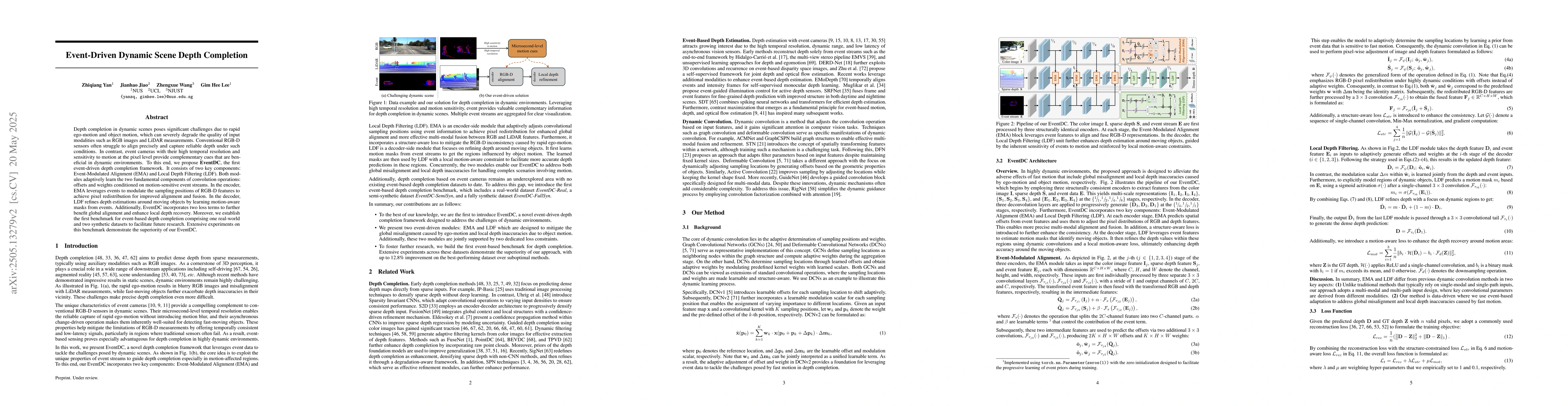
Depth completion in dynamic scenes poses significant challenges due to rapid ego-motion and object motion, which can severely degrade the quality of input modalities such as RGB images and LiDAR measu...
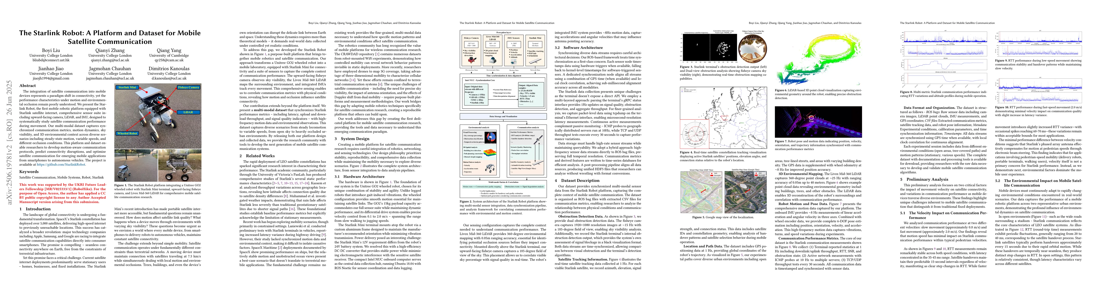
The integration of satellite communication into mobile devices represents a paradigm shift in connectivity, yet the performance characteristics under motion and environmental occlusion remain poorly u...
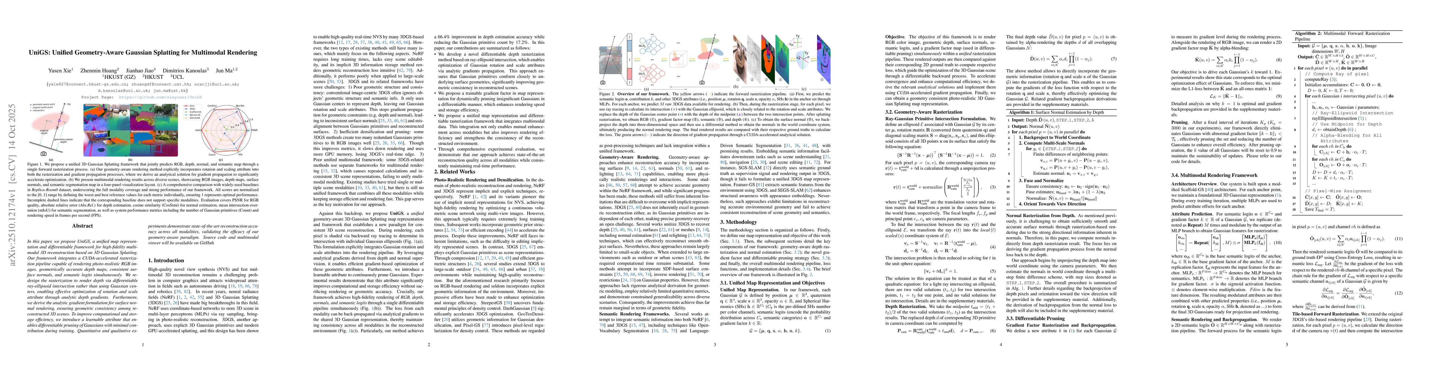
In this paper, we propose UniGS, a unified map representation and differentiable framework for high-fidelity multimodal 3D reconstruction based on 3D Gaussian Splatting. Our framework integrates a CUD...
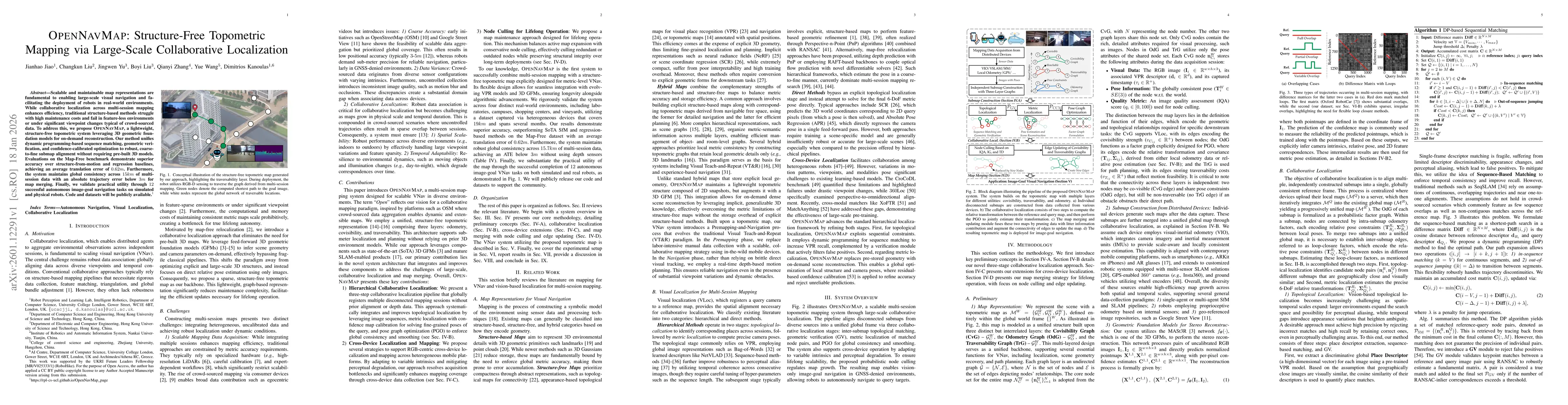
Scalable and maintainable map representations are fundamental to enabling large-scale visual navigation and facilitating the deployment of robots in real-world environments. While collaborative locali...
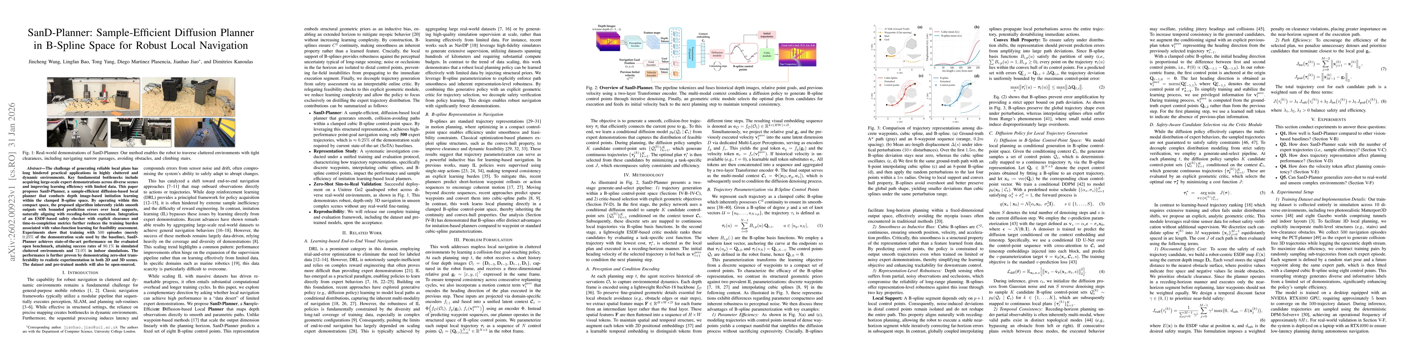
The challenge of generating reliable local plans has long hindered practical applications in highly cluttered and dynamic environments. Key fundamental bottlenecks include acquiring large-scale expert...
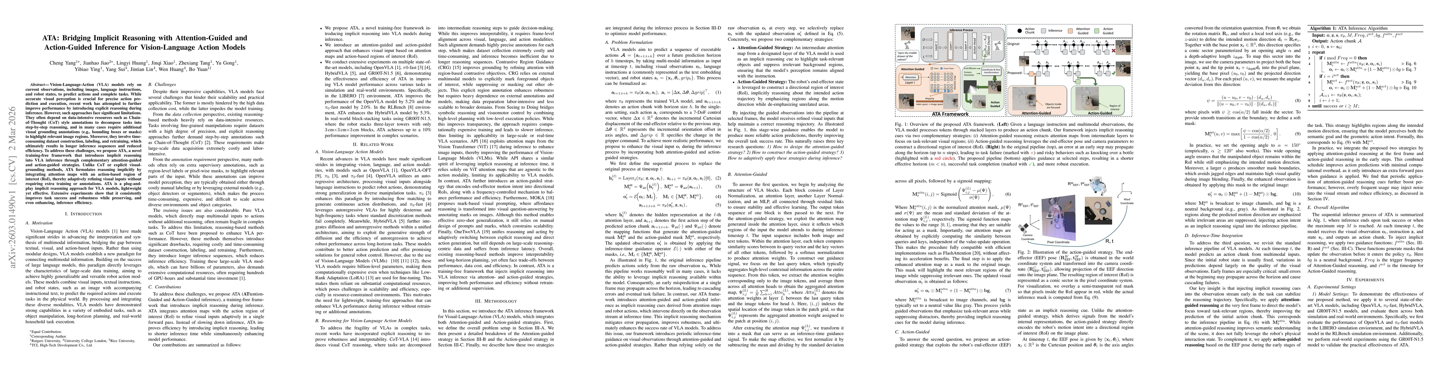
Vision-Language-Action (VLA) models rely on current observations, including images, language instructions, and robot states, to predict actions and complete tasks. While accurate visual perception is ...
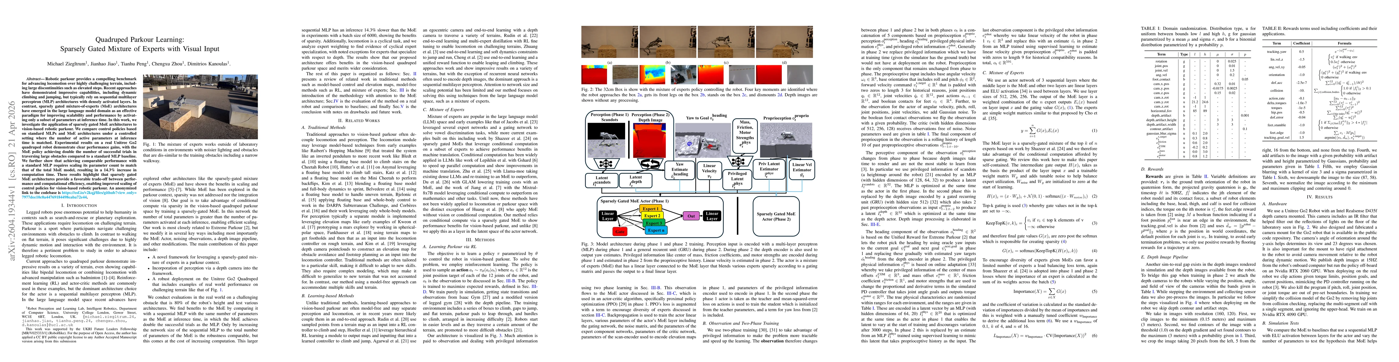
Robotic parkour provides a compelling benchmark for advancing locomotion over highly challenging terrain, including large discontinuities such as elevated steps. Recent approaches have demonstrated im...