Academic Profile
Statistics
Similar Authors
Papers on arXiv
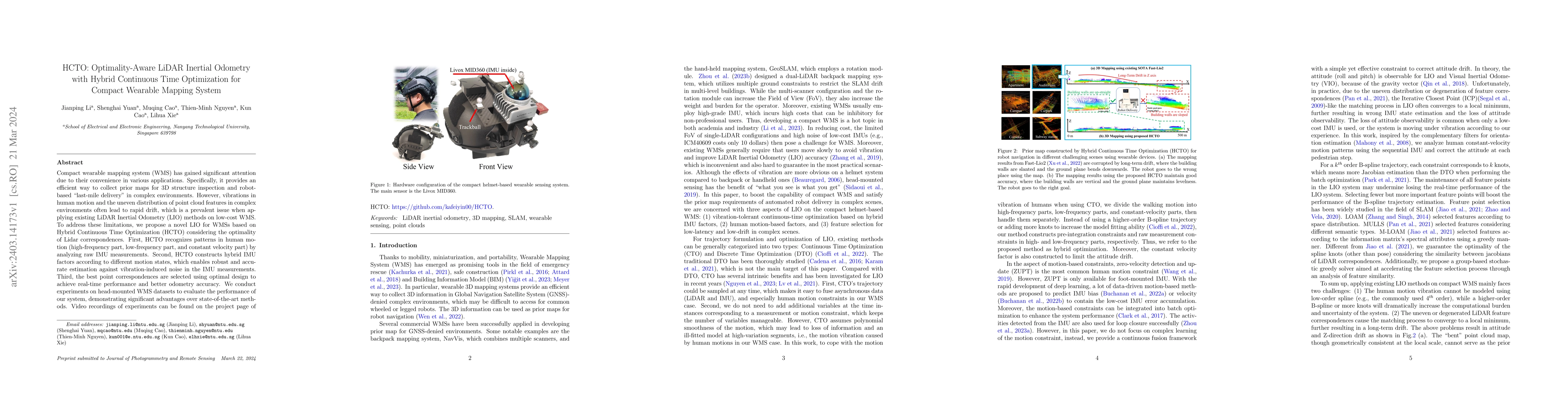
Compact wearable mapping system (WMS) has gained significant attention due to their convenience in various applications. Specifically, it provides an efficient way to collect prior maps for 3D struc...
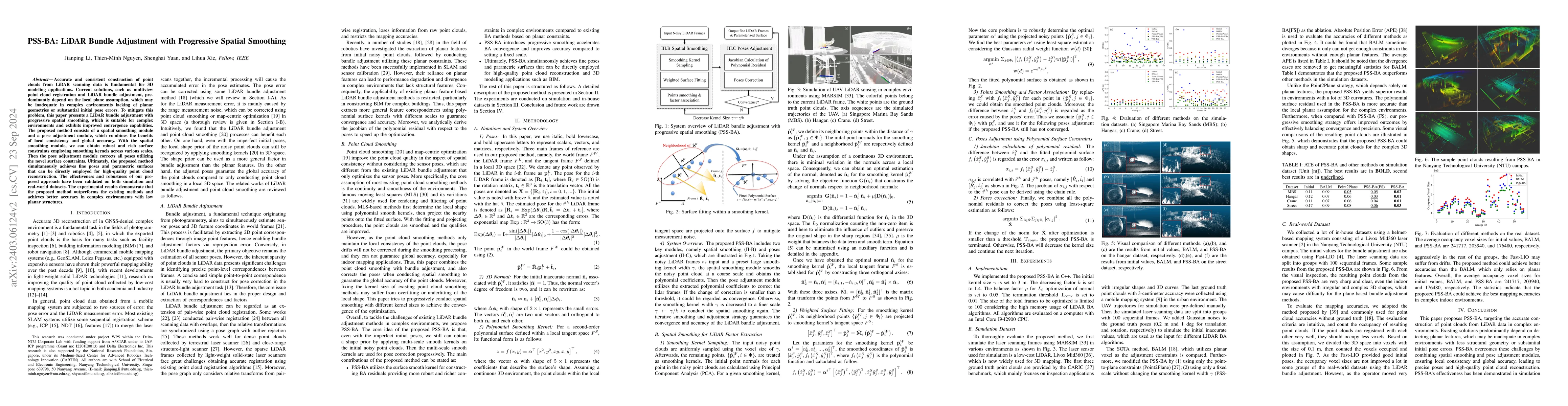
Accurate and consistent construction of point clouds from LiDAR scanning data is fundamental for 3D modeling applications. Current solutions, such as multiview point cloud registration and LiDAR bun...
In this paper, with a set of high-resolution He I 10830 \AA\ filtergrams, we select an area in a plage, very likely an EUV moss area, as an interface layer to follow the clues of coronal heating cha...
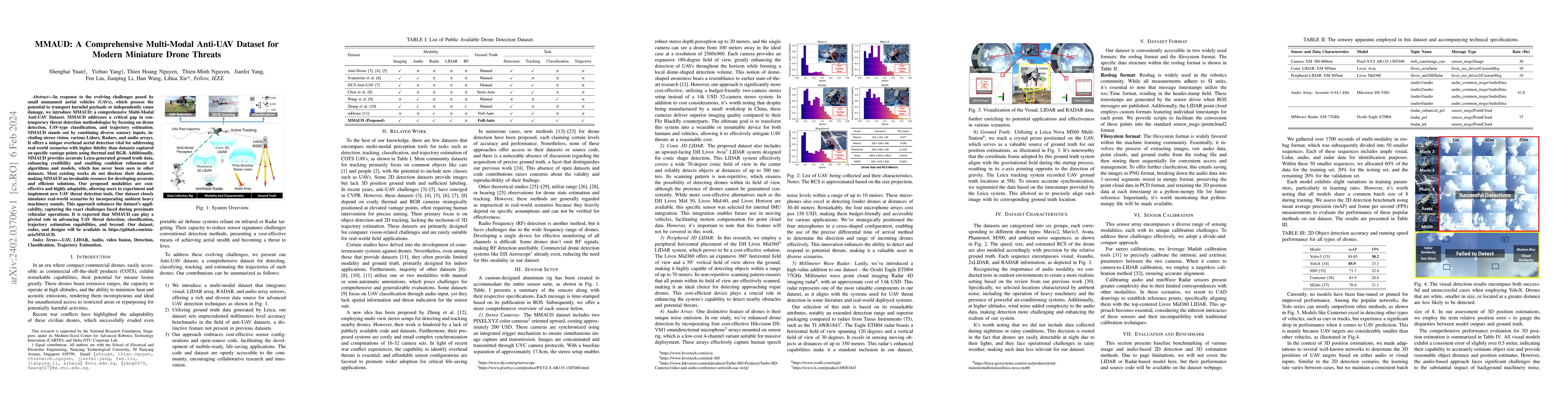
In response to the evolving challenges posed by small unmanned aerial vehicles (UAVs), which possess the potential to transport harmful payloads or independently cause damage, we introduce MMAUD: a ...
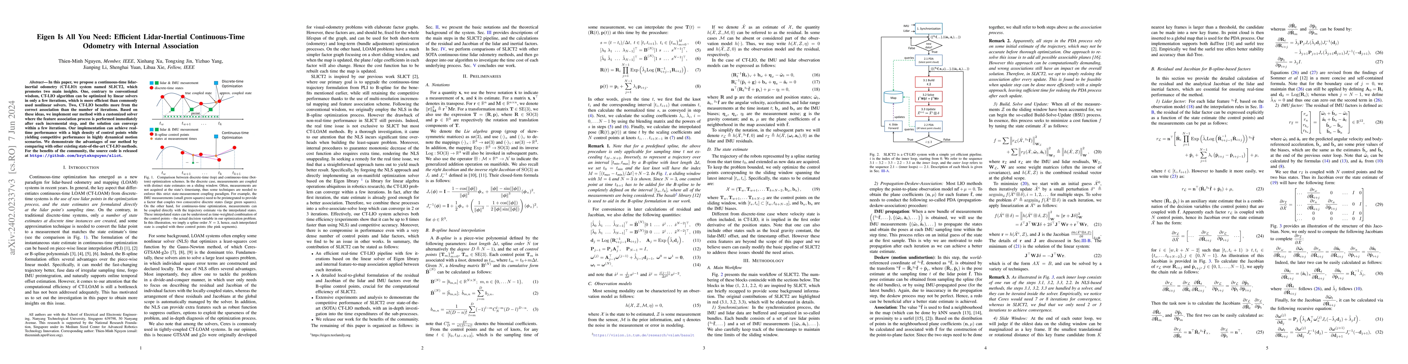
In this paper, we propose a continuous-time lidar-inertial odometry (CT-LIO) system named SLICT2, which promotes two main insights. One, contrary to conventional wisdom, CT-LIO algorithm can be opti...
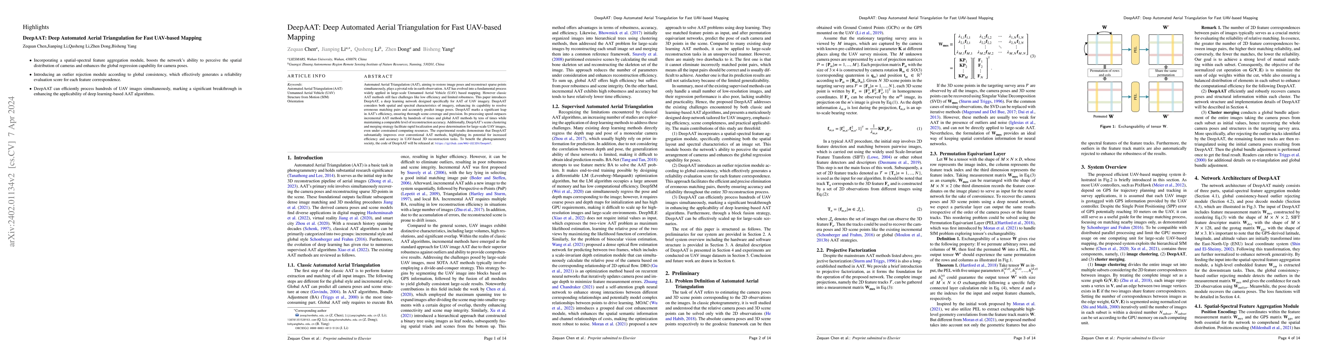
Automated Aerial Triangulation (AAT), aiming to restore image pose and reconstruct sparse points simultaneously, plays a pivotal role in earth observation. With its rich research heritage spanning s...
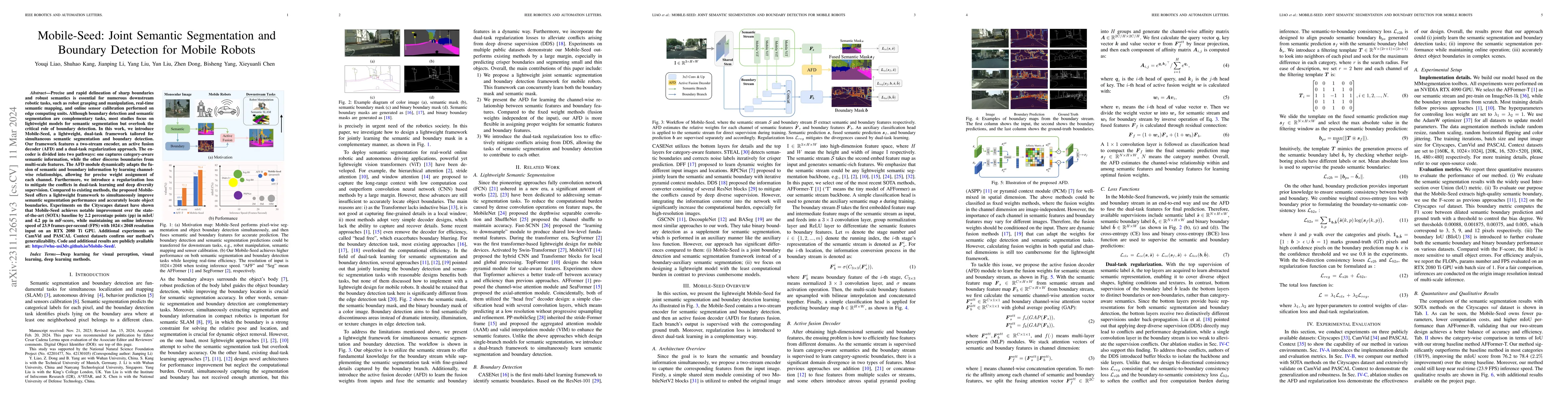
Precise and rapid delineation of sharp boundaries and robust semantics is essential for numerous downstream robotic tasks, such as robot grasping and manipulation, real-time semantic mapping, and on...
In this paper, we study some spanning trees with bounded degree and leaf degree from eigenvalues. For any integer $k\geq2$, a $k$-tree is a spanning tree in which every vertex has degree no more tha...
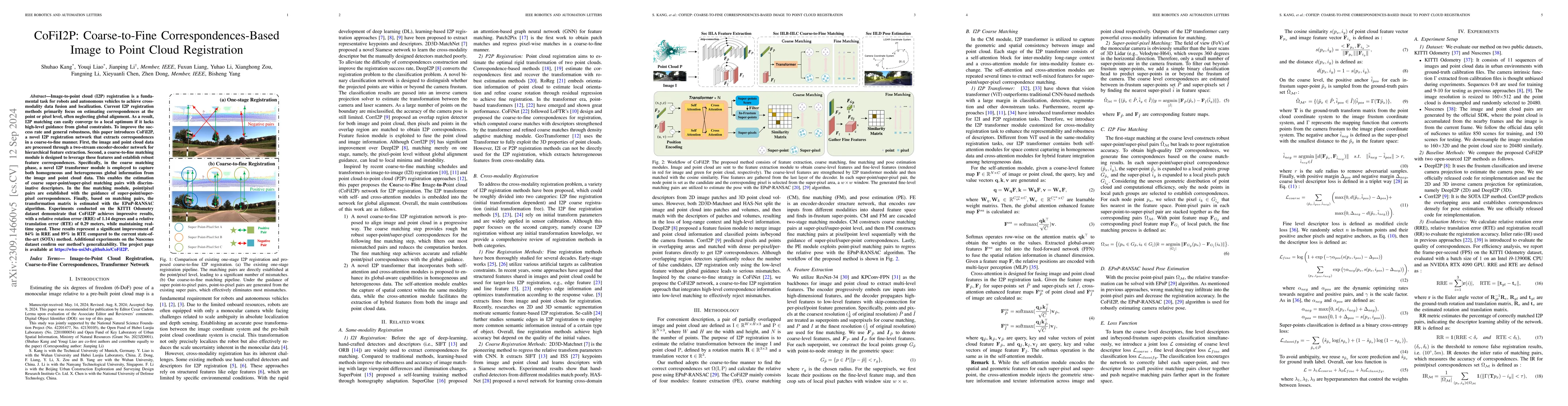
Image-to-point cloud (I2P) registration is a fundamental task for robots and autonomous vehicles to achieve cross-modality data fusion and localization. Existing I2P registration methods estimate co...
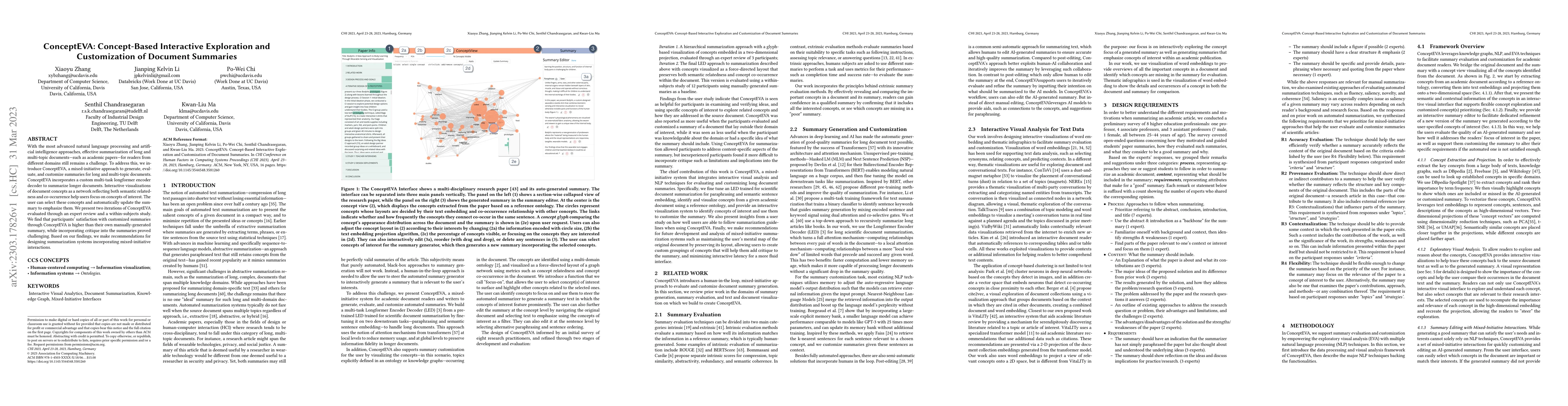
With the most advanced natural language processing and artificial intelligence approaches, effective summarization of long and multi-topic documents -- such as academic papers -- for readers from di...
Let $\mathbb{G}_{n,\gamma}$ be the set of simple and connected graphs on $n$ vertices and with domination number $\gamma$. The graph with minimum spectral radius among $\mathbb{G}_{n,\gamma}$ is cal...
Let $G$ be a $k$-uniform hypergraph with vertex set $V(G)$ and edge set $E(G)$. A connected and acyclic hypergraph is called a supertree. For $0\leq\alpha<1$, the $\alpha$-spectral radius of $G$ is ...
Let $G$ be a graph with adjacency matrix $A(G)$ and let $D(G)$ be a diagonal matrix of the degrees of $G$. In 2017, Nikiforov defined the $A_{\alpha}$-matrix of $G$ as \begin{equation*} A_{\alpha}(G...
Magnetic topological semimetals, a novel state of quantum matter with nontrivial band topology, have emerged as a new frontier in physics and materials science. An external stimulus like temperature...
The distance matrix $\mathcal{D}$ of a connected graph $G$ is the matrix indexed by the vertices of $G$ which entry $\mathcal{D}_{i,j}$ equals the distance between the vertices $v_i$ and $v_j$. The ...
The zeroth-order general Randi\'c index of graph $G=(V_G,E_G)$, denoted by $^0R_{\alpha}(G)$, is the sum of items $(d_{v})^{\alpha}$ over all vertices $v\in V_G$, where $\alpha$ is a pertinently cho...
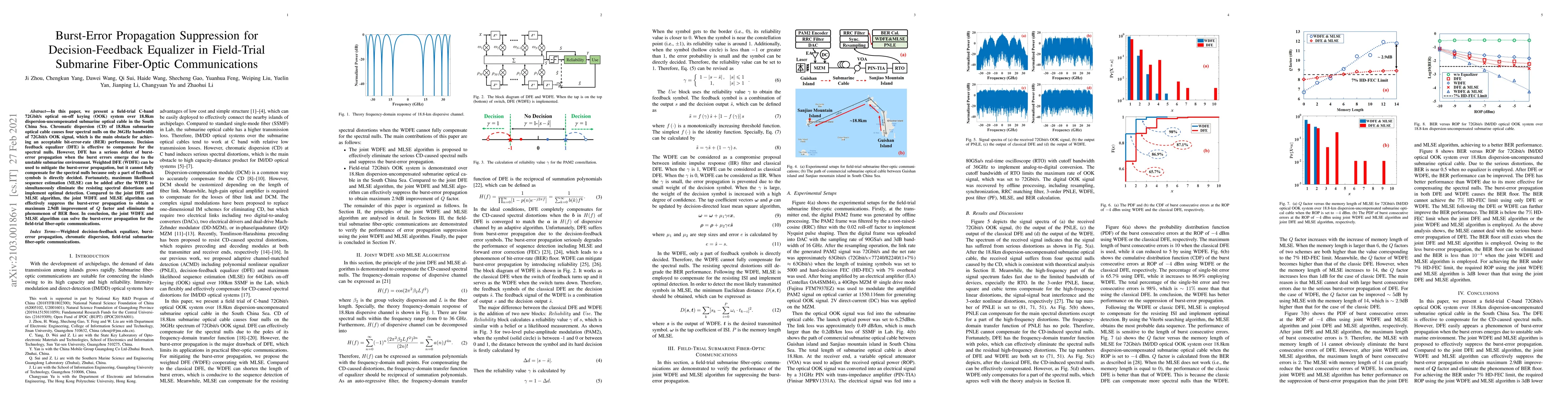
In this paper, we present a field-trial C-band 72Gbit/s optical on-off keying (OOK) system over 18.8km dispersion-uncompensated submarine optical cable in the South China Sea. Chromatic dispersion (...
The signless Laplacian matrix of a graph $G$ is given by $Q(G)=D(G)+A(G)$, where $D(G)$ is a diagonal matrix of vertex degrees and $A(G)$ is the adjacency matrix. The largest eigenvalue of $Q(G)$ is...
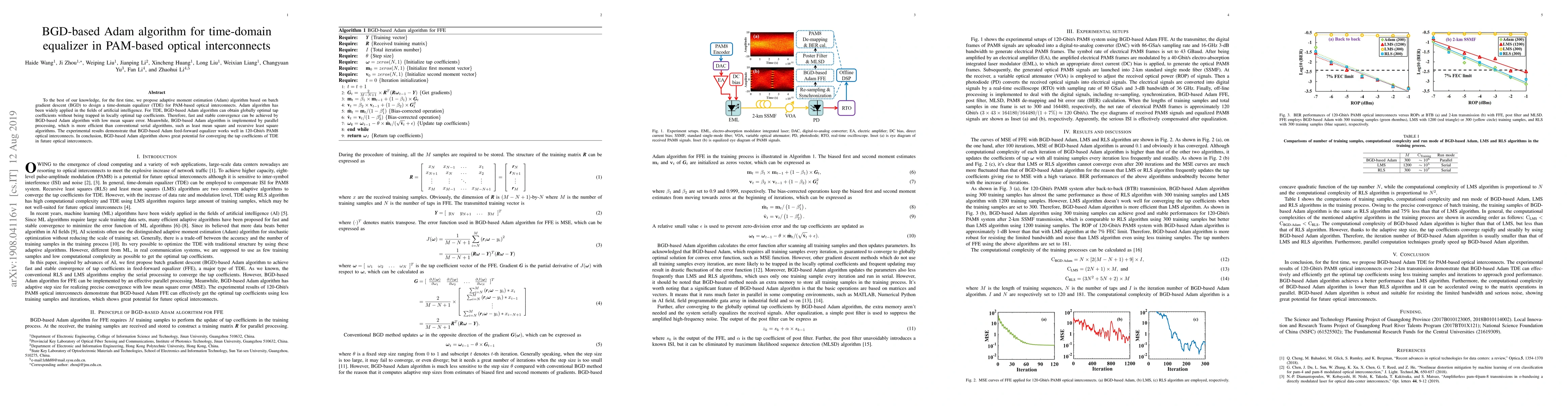
To the best of our knowledge, for the first time, we propose adaptive moment estimation (Adam) algorithm based on batch gradient descent (BGD) to design a time-domain equalizer (TDE) for PAM-based o...
Let $G_n$ be a graph obtained by the strong product of $P_2$ and $C_n$, where $n\geqslant3$. In this paper, explicit expressions for the Kirchhoff index, multiplicative degree-Kirchhoff index and nu...
A fractional matching of a graph $G$ is a function $f$ giving each edge a number in $[0,1]$ such that $\sum_{e\in\Gamma(v)}f(e)\leq1$ for each vertex $v\in V(G)$, where $\Gamma(v)$ is the set of edg...
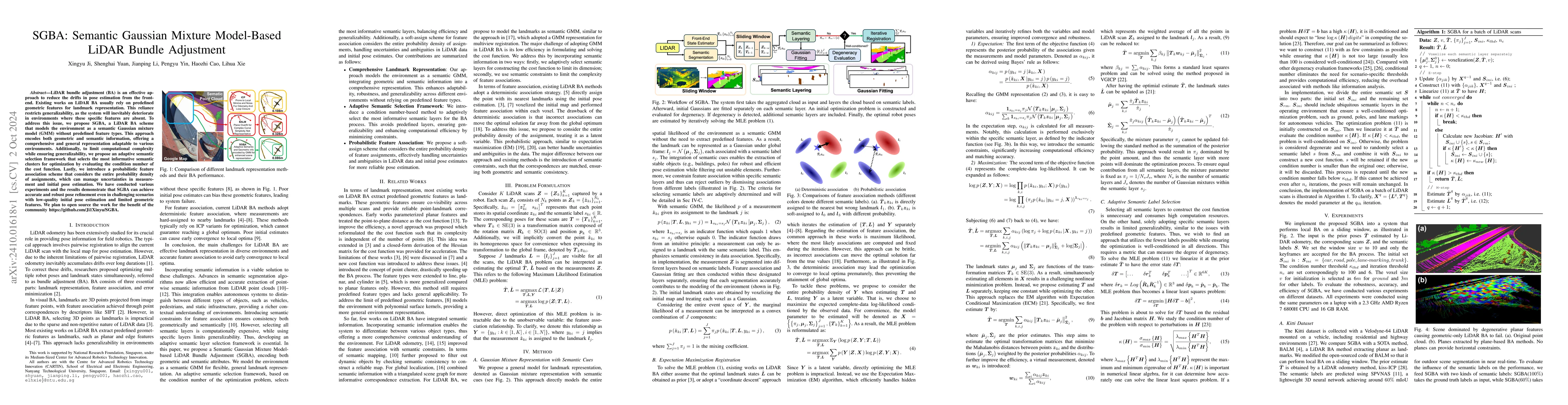
LiDAR bundle adjustment (BA) is an effective approach to reduce the drifts in pose estimation from the front-end. Existing works on LiDAR BA usually rely on predefined geometric features for landmark ...
Wearable laser scanning (WLS) system has the advantages of flexibility and portability. It can be used for determining the user's path within a prior map, which is a huge demand for applications in pe...
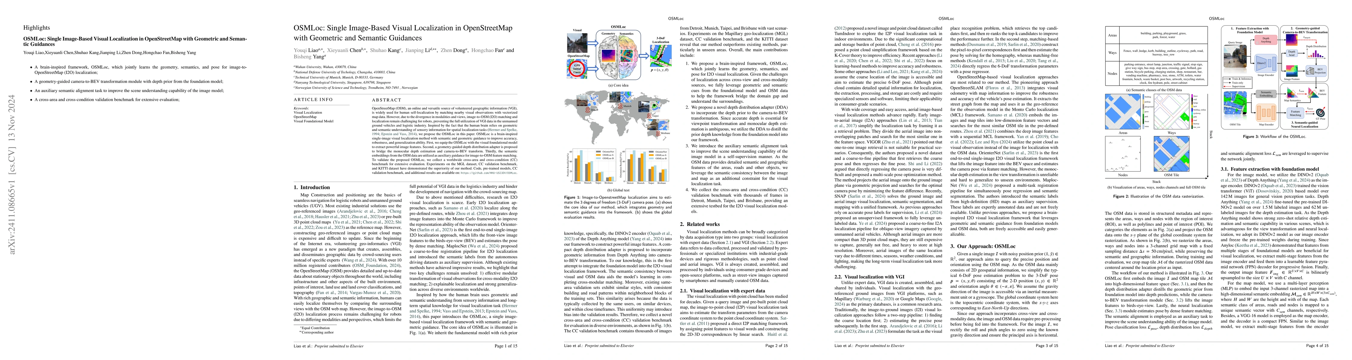
OpenStreetMap (OSM), an online and versatile source of volunteered geographic information (VGI), is widely used for human self-localization by matching nearby visual observations with vectorized map d...
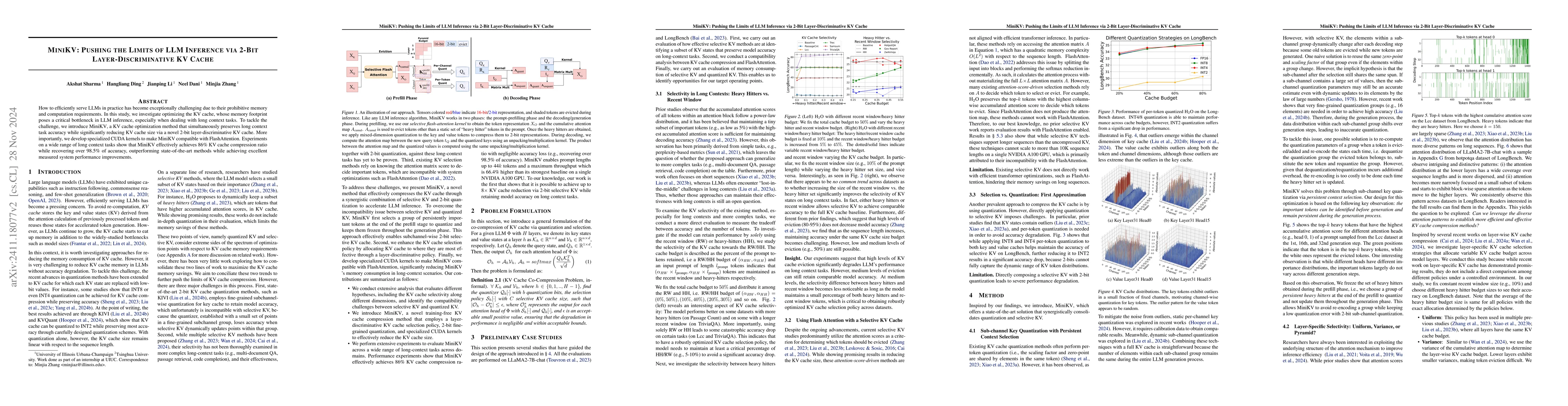
How to efficiently serve LLMs in practice has become exceptionally challenging due to their prohibitive memory and computation requirements. In this study, we investigate optimizing the KV cache, whos...
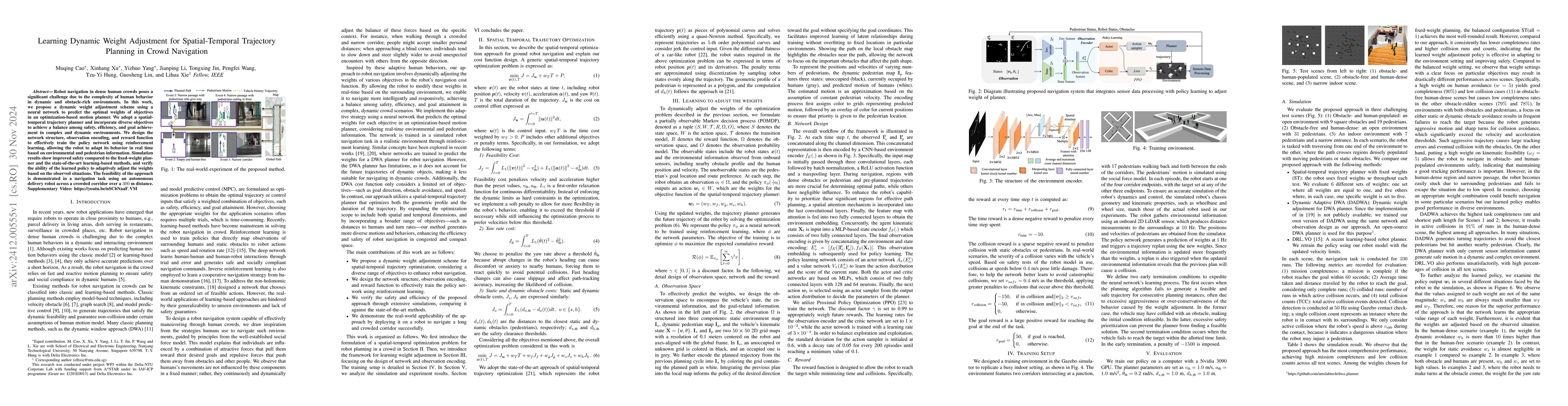
Robot navigation in dense human crowds poses a significant challenge due to the complexity of human behavior in dynamic and obstacle-rich environments. In this work, we propose a dynamic weight adjust...
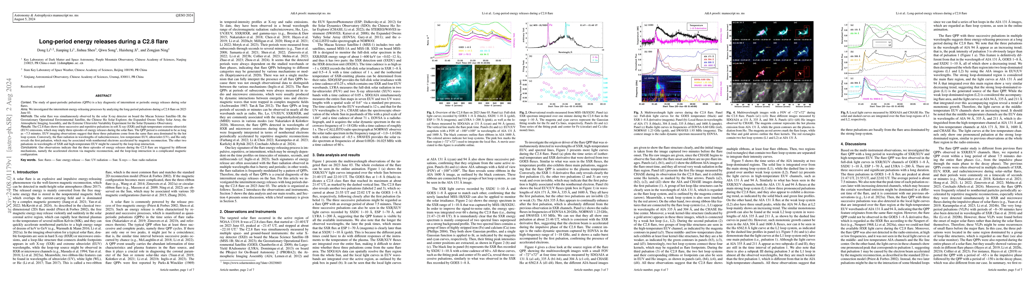
We investigated the intermittent energy-releasing processes by analyzing the long-period pulsations during a C2.8 flare on 2023 June 03. The C2.8 flare shows three successive and repetitive pulsations...
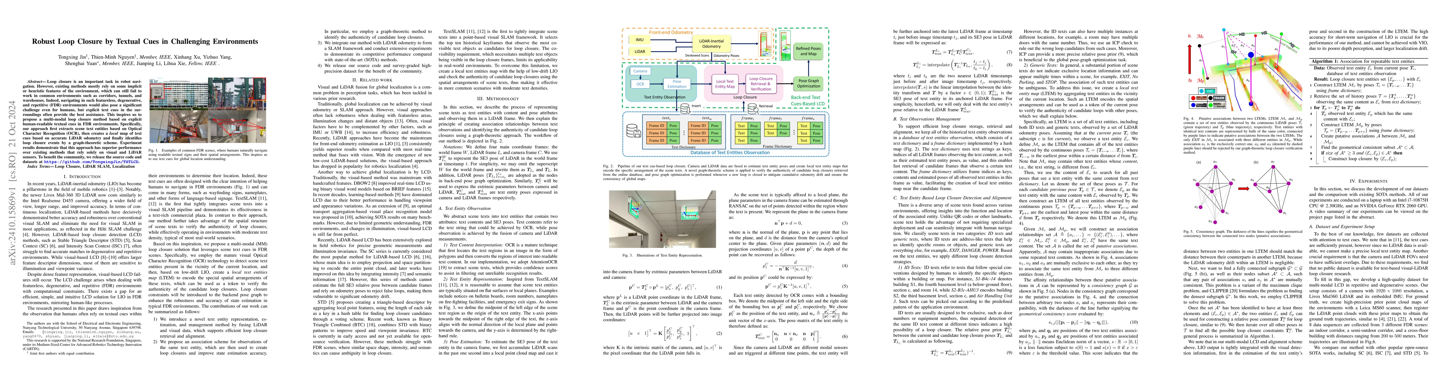
Loop closure is an important task in robot navigation. However, existing methods mostly rely on some implicit or heuristic features of the environment, which can still fail to work in common environme...
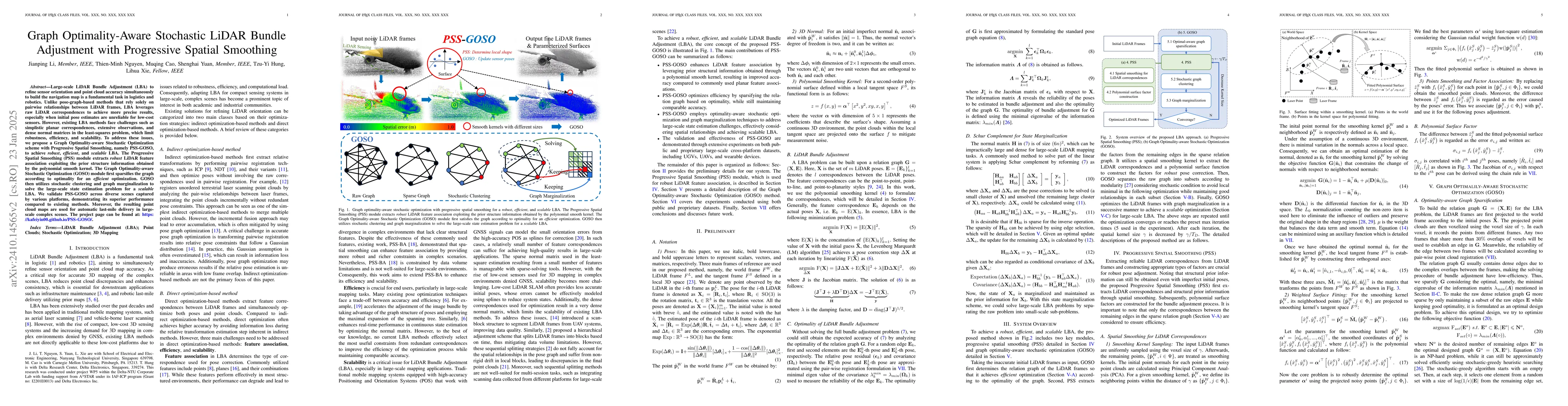
Large-scale LiDAR Bundle Adjustment (LBA) for refining sensor orientation and point cloud accuracy simultaneously is a fundamental task in photogrammetry and robotics, particularly as low-cost 3D sens...
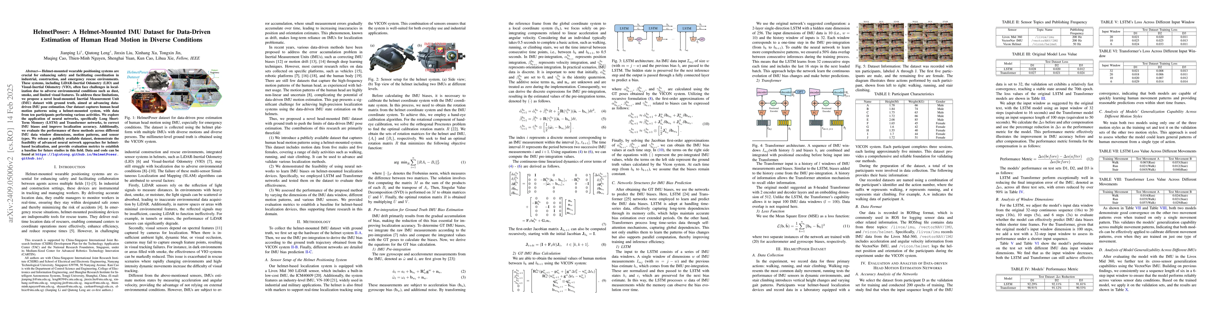
Helmet-mounted wearable positioning systems are crucial for enhancing safety and facilitating coordination in industrial, construction, and emergency rescue environments. These systems, including LiDA...
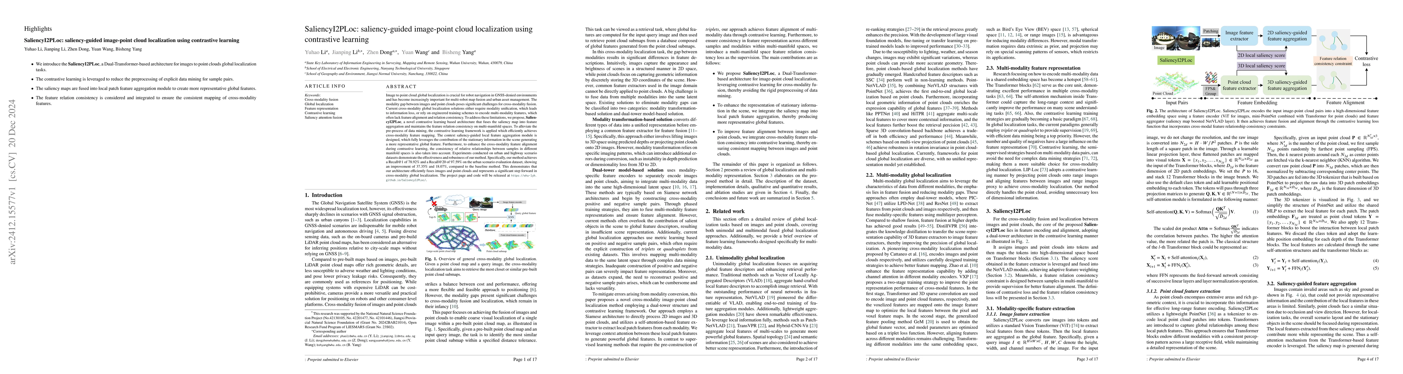
Image to point cloud global localization is crucial for robot navigation in GNSS-denied environments and has become increasingly important for multi-robot map fusion and urban asset management. The mo...
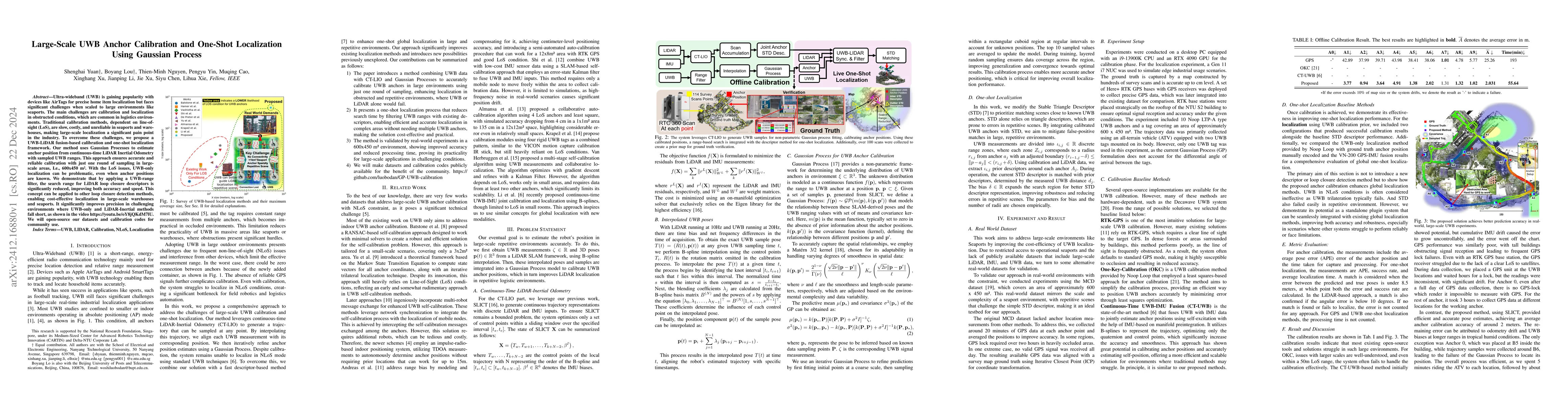
Ultra-wideband (UWB) is gaining popularity with devices like AirTags for precise home item localization but faces significant challenges when scaled to large environments like seaports. The main chall...
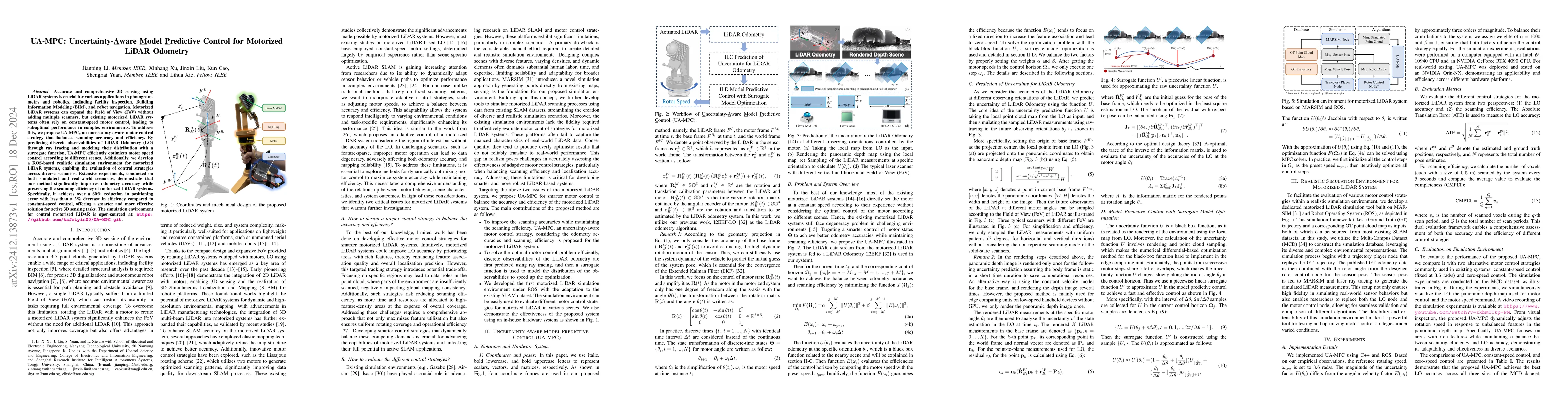
Accurate and comprehensive 3D sensing using LiDAR systems is crucial for various applications in photogrammetry and robotics, including facility inspection, Building Information Modeling (BIM), and ro...
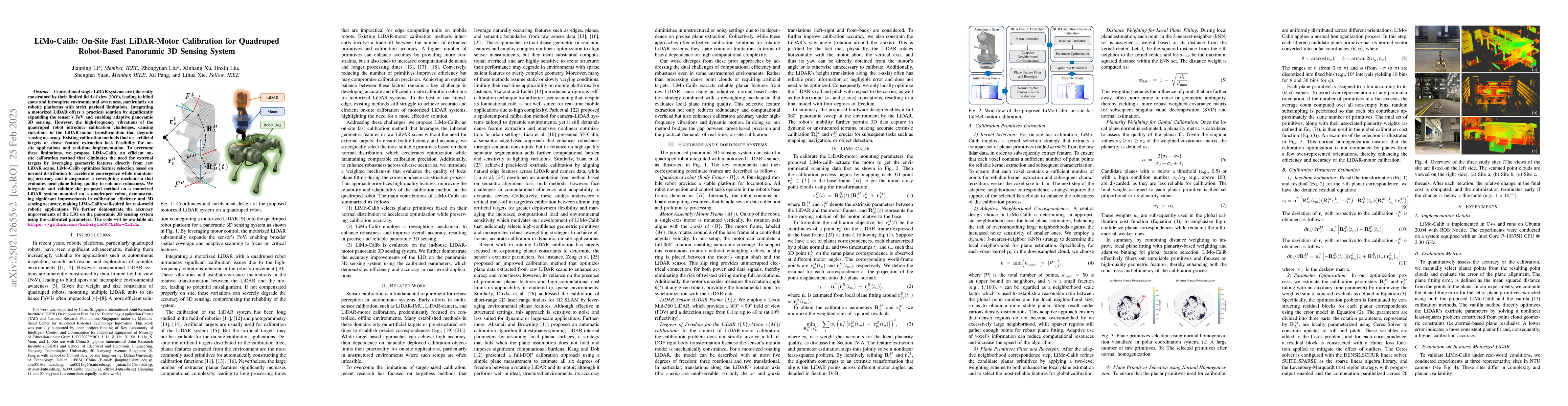
Conventional single LiDAR systems are inherently constrained by their limited field of view (FoV), leading to blind spots and incomplete environmental awareness, particularly on robotic platforms with...
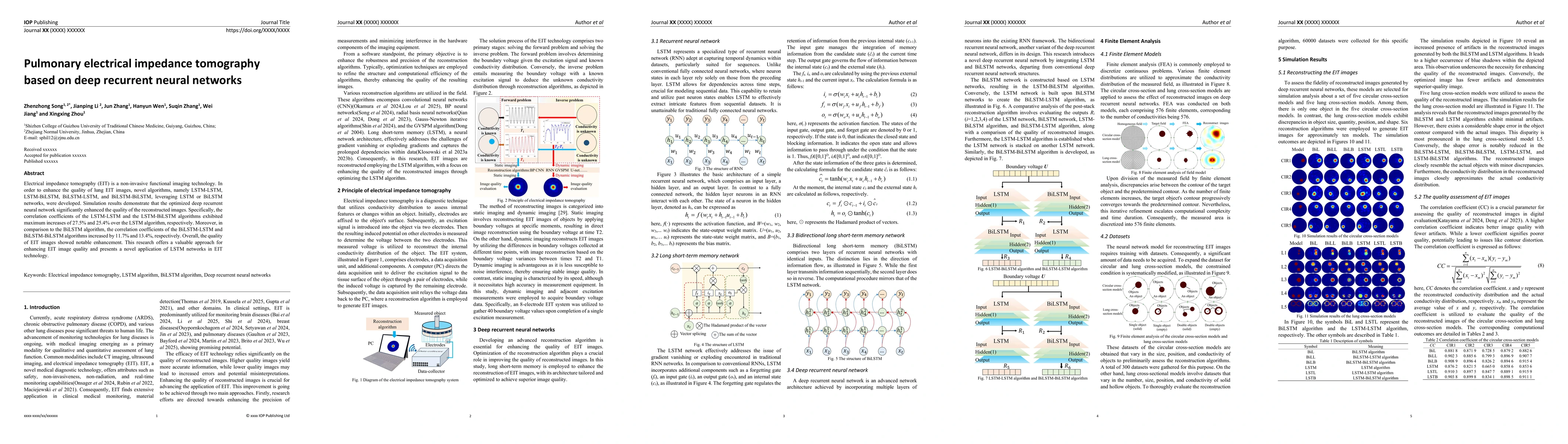
Electrical impedance tomography (EIT) is a non-invasive functional imaging technology. In order to enhance the quality of lung EIT images, novel algorithms, namely LSTM-LSTM, LSTM-BiLSTM, BiLSTM-LSTM,...
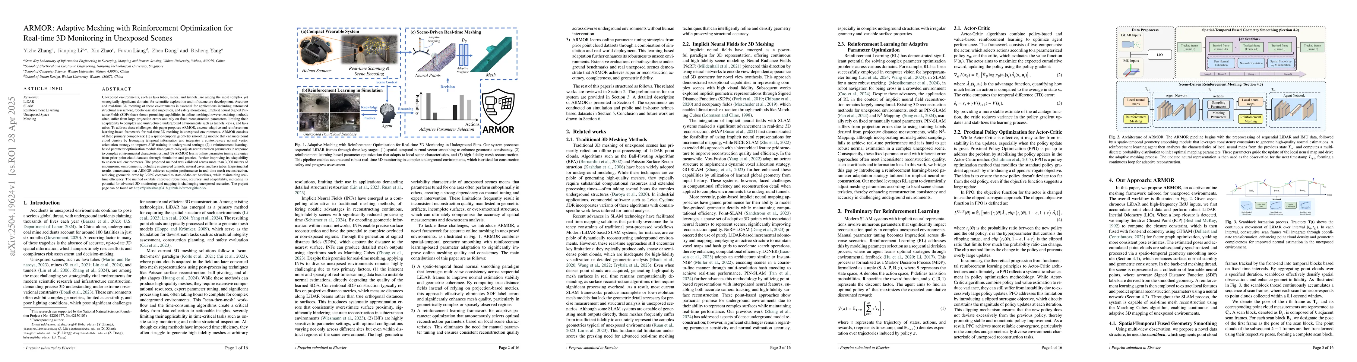
Unexposed environments, such as lava tubes, mines, and tunnels, are among the most complex yet strategically significant domains for scientific exploration and infrastructure development. Accurate and...
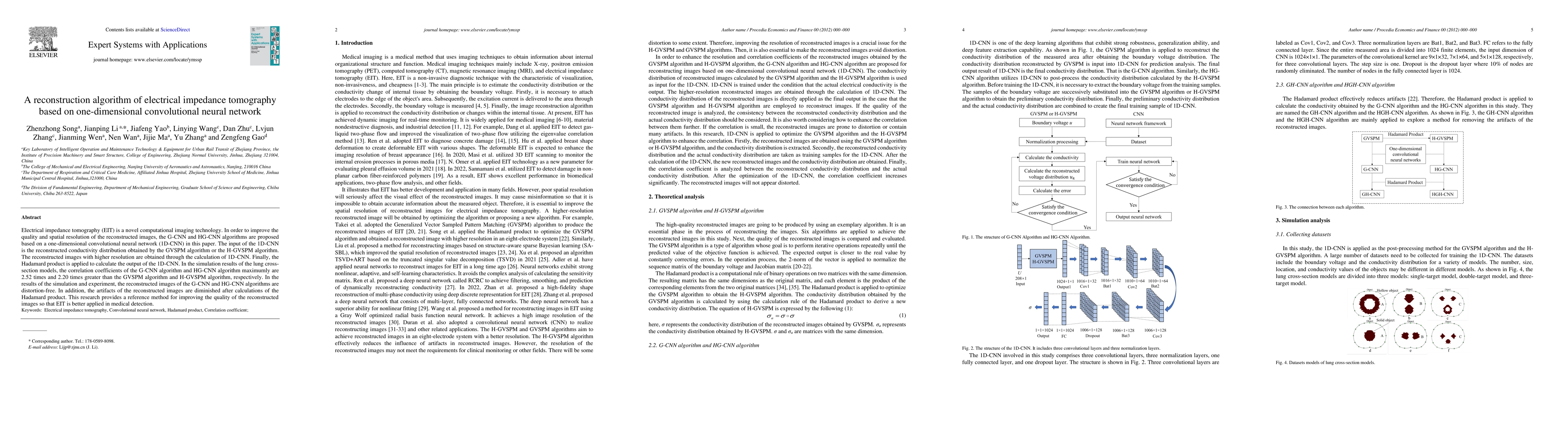
Electrical impedance tomography (EIT) is a novel computational imaging technology. In order to improve the quality and spatial resolution of the reconstructed images, the G-CNN and HG-CNN algorithms a...
Point cloud place recognition (PCPR) plays a crucial role in photogrammetry and robotics applications such as autonomous driving, intelligent transportation, and augmented reality. In real-world large...
Emerging expert-specialized Mixture-of-Experts (MoE) architectures, such as DeepSeek-MoE, deliver strong model quality through fine-grained expert segmentation and large top-k routing. However, their ...
Accurate visual localization in dense urban environments poses a fundamental task in photogrammetry, geospatial information science, and robotics. While imagery is a low-cost and widely accessible sen...
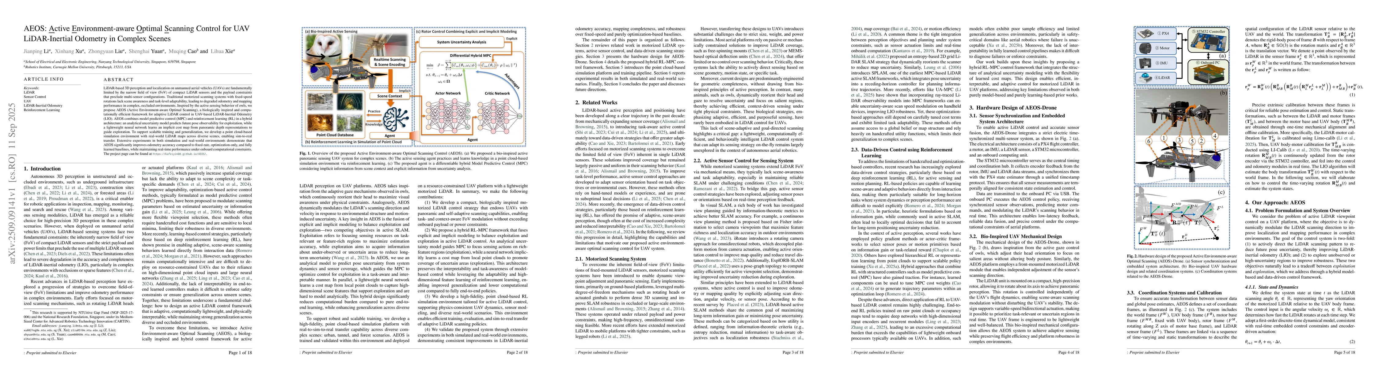
LiDAR-based 3D perception and localization on unmanned aerial vehicles (UAVs) are fundamentally limited by the narrow field of view (FoV) of compact LiDAR sensors and the payload constraints that prec...
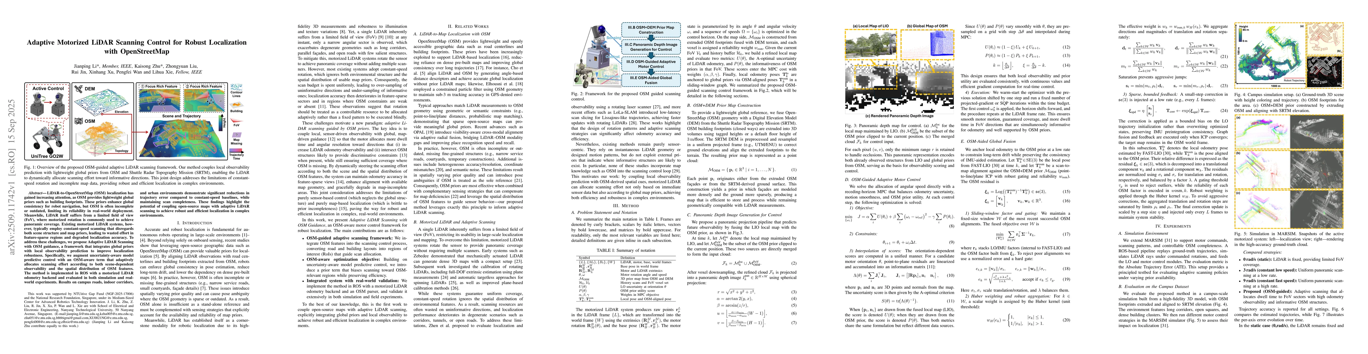
LiDAR-to-OpenStreetMap (OSM) localization has gained increasing attention, as OSM provides lightweight global priors such as building footprints. These priors enhance global consistency for robot navi...
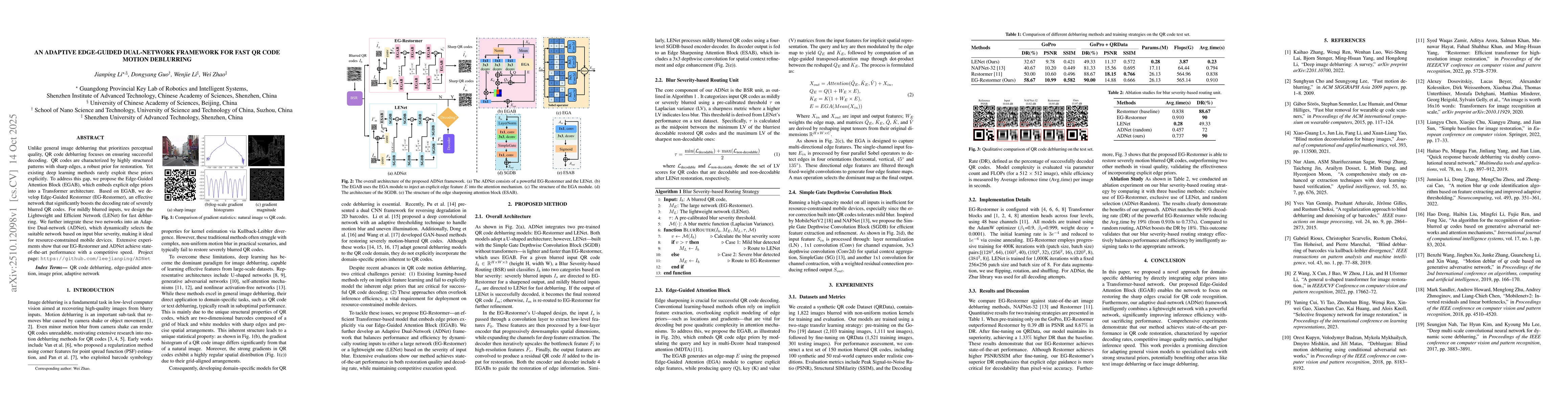
Unlike general image deblurring that prioritizes perceptual quality, QR code deblurring focuses on ensuring successful decoding. QR codes are characterized by highly structured patterns with sharp edg...
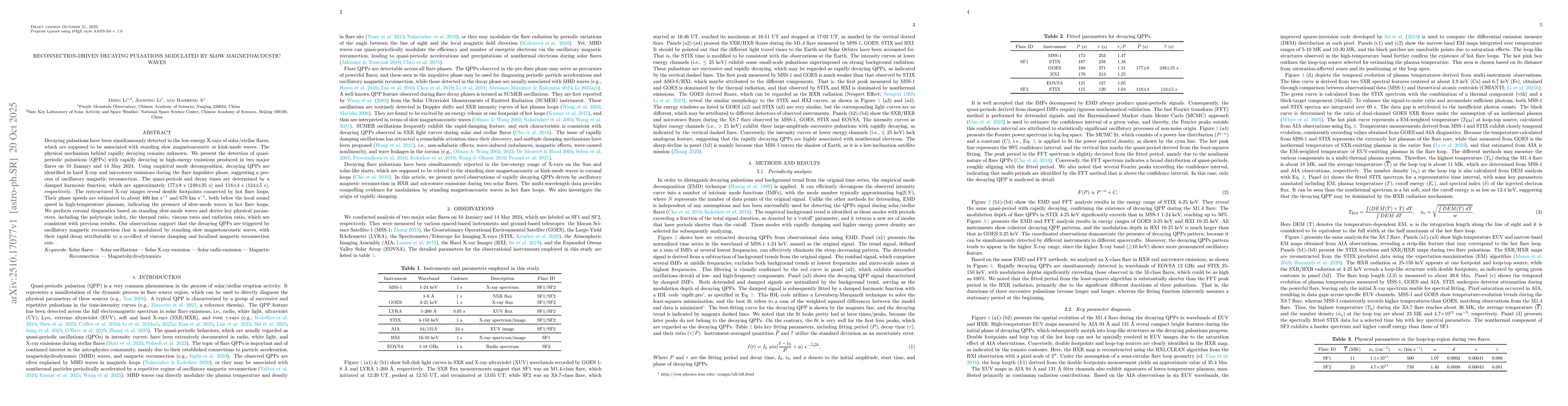
Decaying pulsations have been simultaneously detected in the low-energy X-rays of solar/stellar flares, which are supposed to be associated with standing slow magnetoacoustic or kink-mode waves. The p...
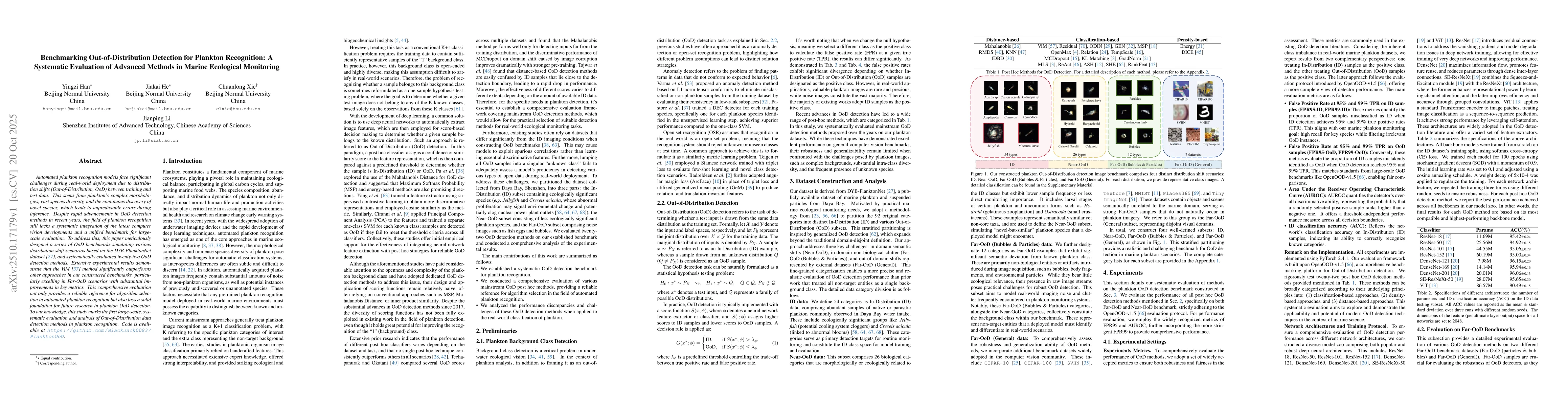
Automated plankton recognition models face significant challenges during real-world deployment due to distribution shifts (Out-of-Distribution, OoD) between training and test data. This stems from pla...
Point Cloud-based Place Recognition (PCPR) demonstrates considerable potential in applications such as autonomous driving, robot localization and navigation, and map update. In practical applications,...
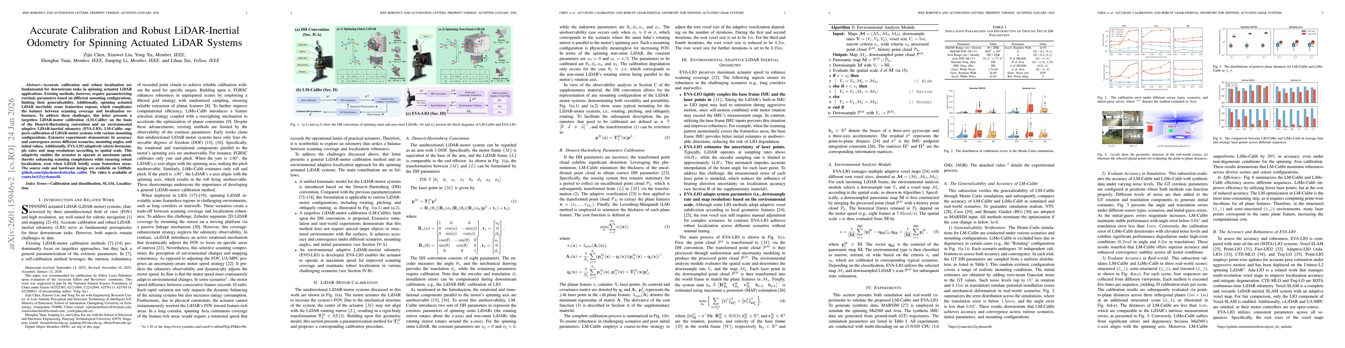
Accurate calibration and robust localization are fundamental for downstream tasks in spinning actuated LiDAR applications. Existing methods, however, require parameterizing extrinsic parameters based ...
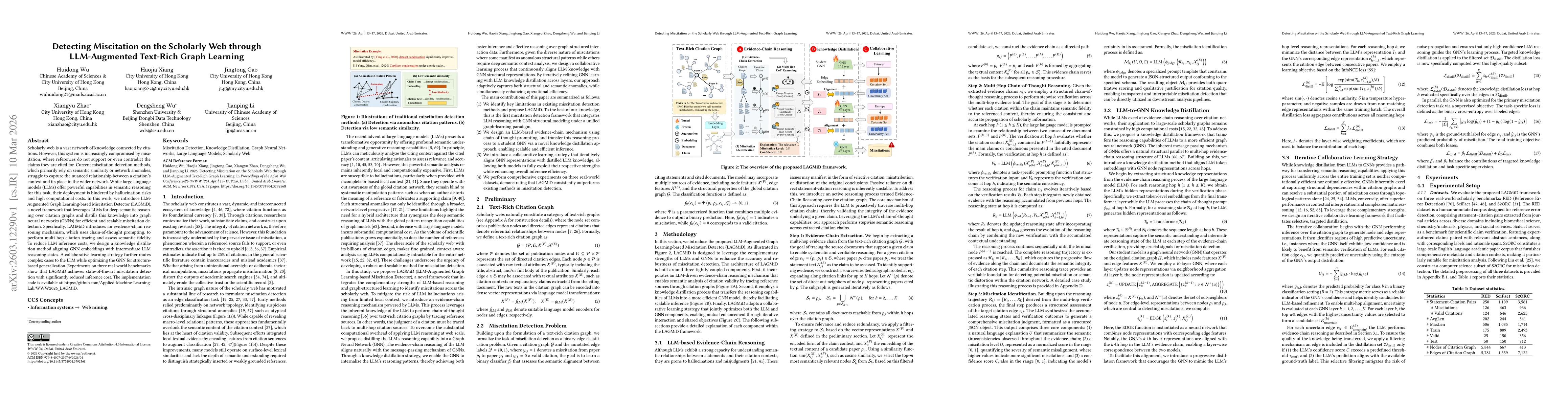
Scholarly web is a vast network of knowledge connected by citations. However, this system is increasingly compromised by miscitation, where references do not support or even contradict the claims they...
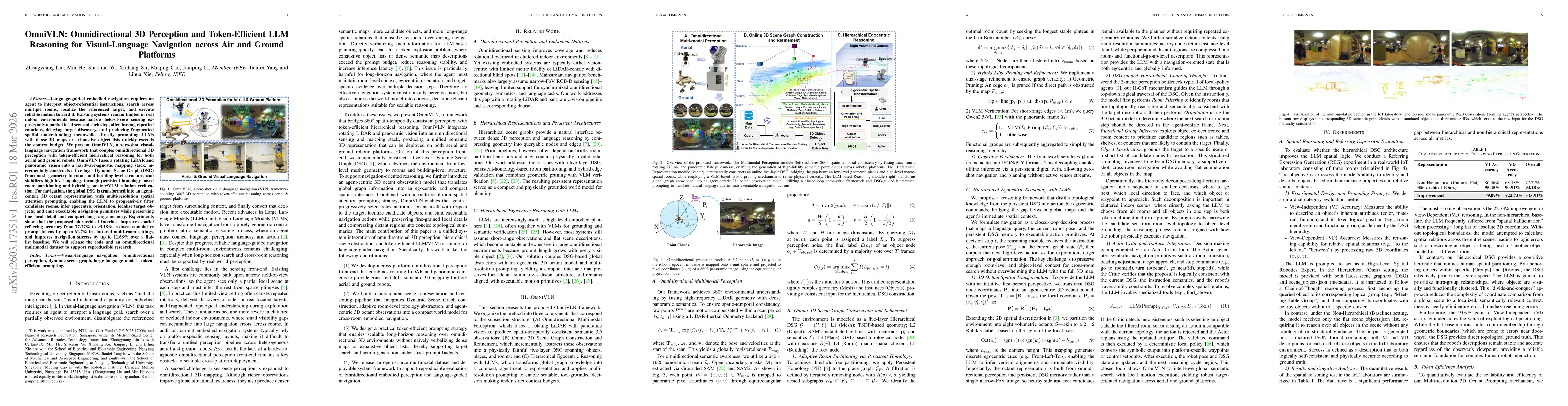
Language-guided embodied navigation requires an agent to interpret object-referential instructions, search across multiple rooms, localize the referenced target, and execute reliable motion toward it....
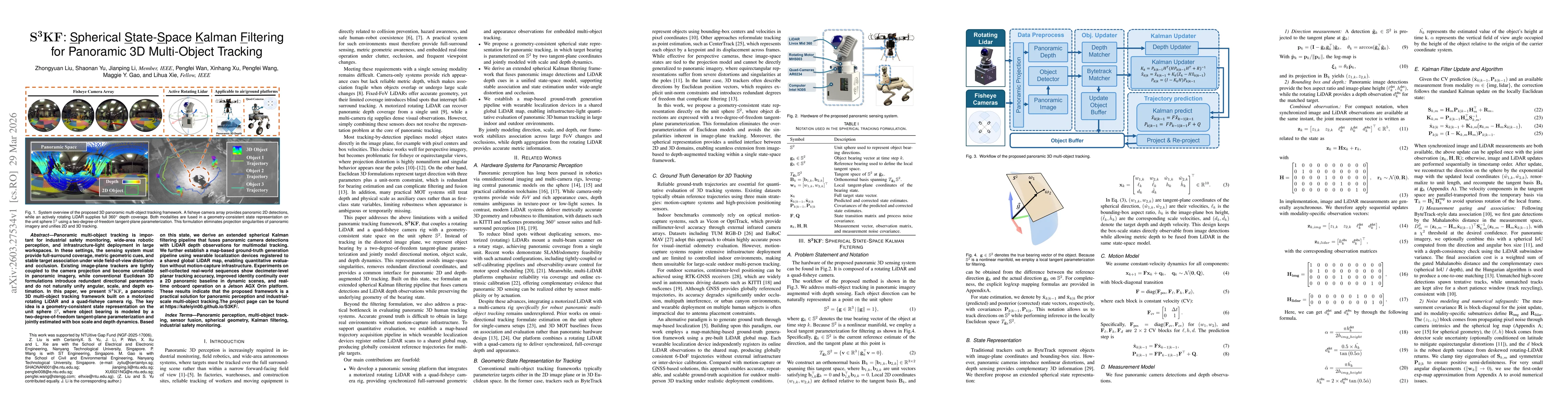
Panoramic multi-object tracking is important for industrial safety monitoring, wide-area robotic perception, and infrastructure-light deployment in large workspaces. In these settings, the sensing sys...
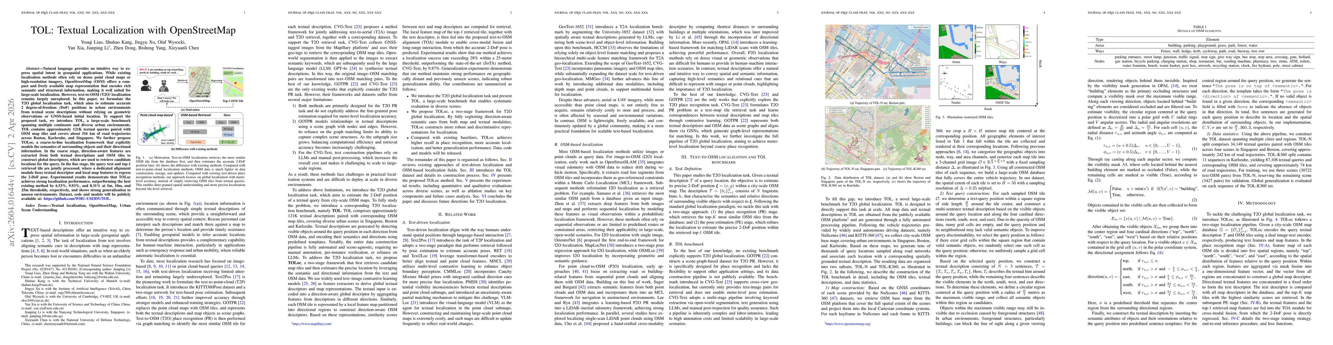
Natural language provides an intuitive way to express spatial intent in geospatial applications. While existing localization methods often rely on dense point cloud maps or high-resolution imagery, Op...
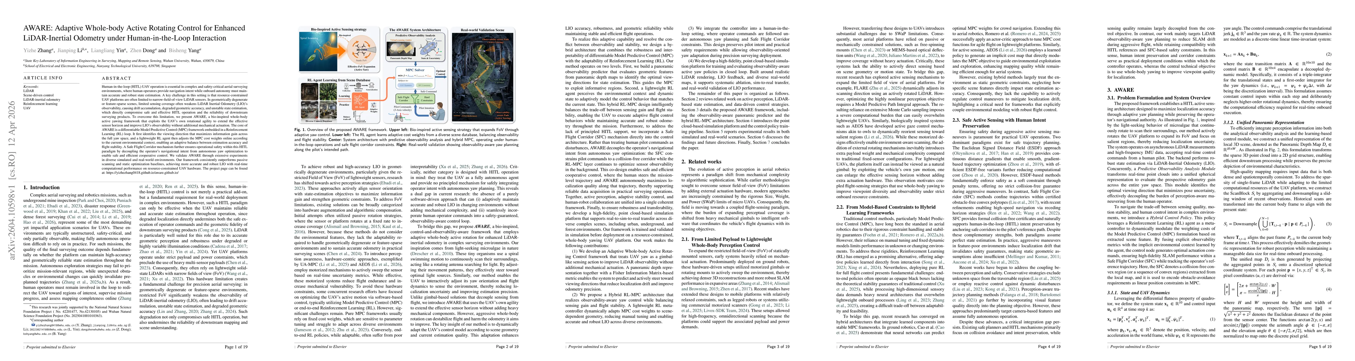
Human-in-the-loop (HITL) UAV operation is essential in complex and safety-critical aerial surveying environments, where human operators provide navigation intent while onboard autonomy must maintain a...
We traced the origin of very long-periodic pulsations (VLPs) in type-I burst chains on 2024 February 14. Seven successive and repetitive pulsation structures appeared in radio dynamic spectra in the m...
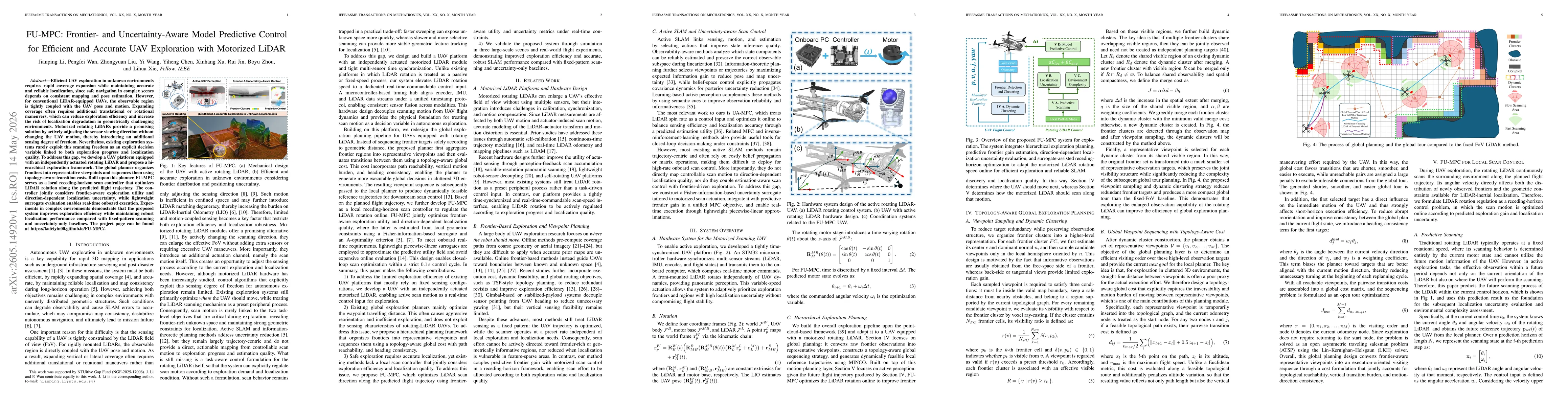
Efficient UAV exploration in unknown environments requires rapid coverage expansion while maintaining accurate and reliable localization, since safe navigation in complex scenes depends on consistent ...
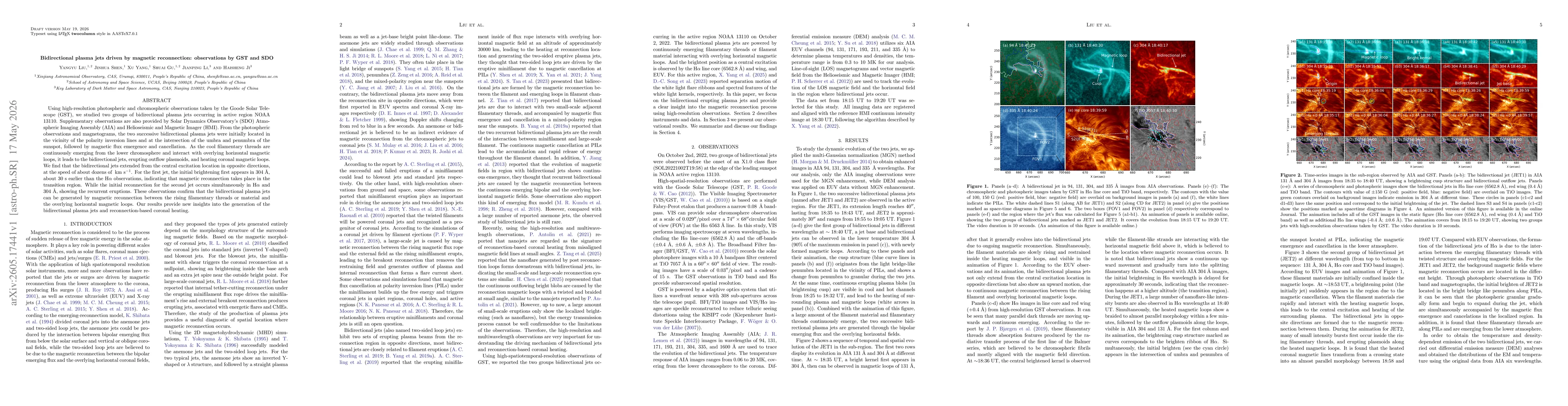
Using high-resolution photospheric and chromospheric observations taken by the Goode Solar Telescope (GST), we studied two groups of bidirectional plasma jets occurring in active region NOAA 13110. Su...
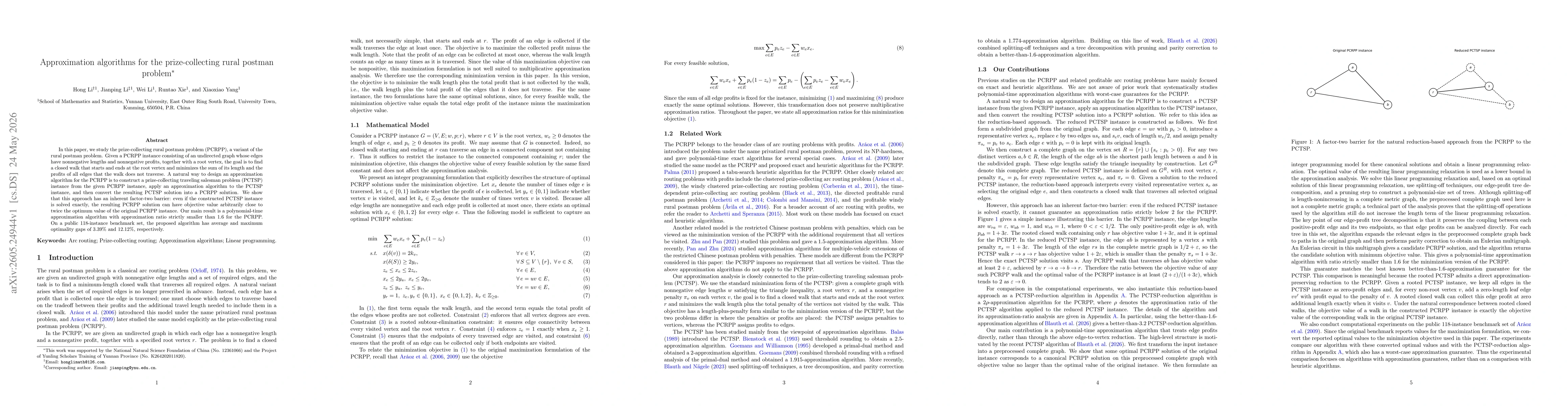
In this paper, we study the prize-collecting rural postman problem (PCRPP), a variant of the rural postman problem. Given a PCRPP instance consisting of an undirected graph whose edges have nonnegativ...
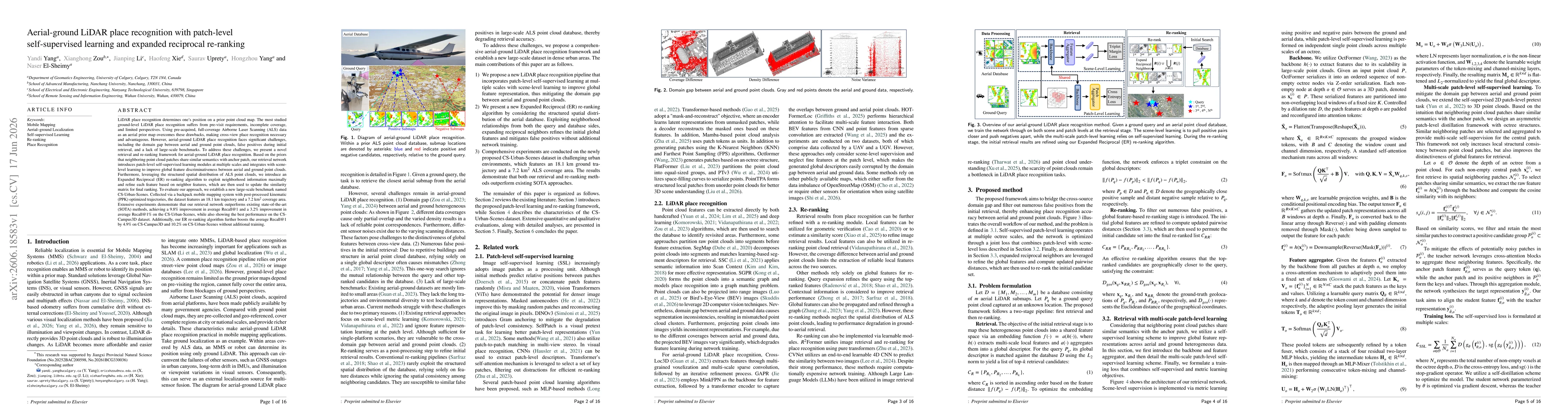
LiDAR place recognition determines one's position on a prior point cloud map. The most studied ground-level LiDAR place recognition suffers from pre-visit requirements, incomplete coverage, and limite...