ArxivLens
J
Researcher

Jianxi Huang

12 papers on arXiv

12 arXiv Papers
10 Total Publications
Profile

Academic Profile

Name Hua Jianxi
Total Papers 10
Scholar Profile View on Semantic Scholar
Metrics

Statistics

12 arXiv Papers
10 Total Publications
Publications

Papers on arXiv

Thumbnail for Layered Image Vectorization via Semantic Simplification
arXiv
Layered Image Vectorization via Semantic Simplification

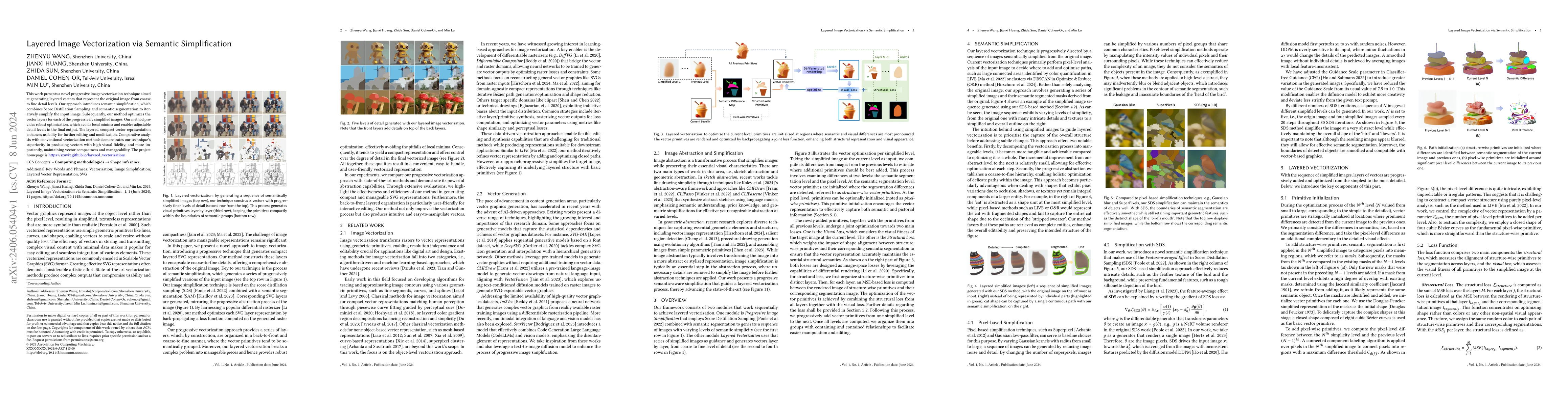
This work presents a novel progressive image vectorization technique aimed at generating layered vectors that represent the original image from coarse to fine detail levels. Our approach introduces ...

Thumbnail for Low Saturation Confidence Distribution-based Test-Time Adaptation for
  Cross-Domain Remote Sensing Image Classification
arXiv
Low Saturation Confidence Distribution-based Test-Time Adaptation for Cross-Domain Remote Sensing Image Classification

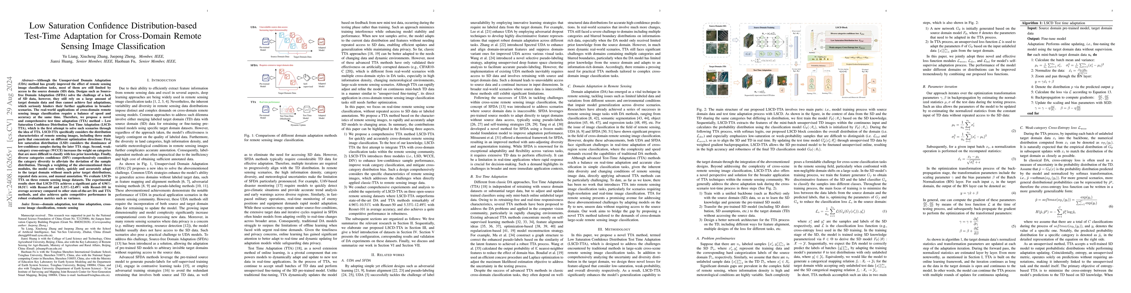
Although the Unsupervised Domain Adaptation (UDA) method has improved the effect of remote sensing image classification tasks, most of them are still limited by access to the source domain (SD) data. ...

Thumbnail for Can Large Multimodal Models Understand Agricultural Scenes? Benchmarking
  with AgroMind
arXiv
Can Large Multimodal Models Understand Agricultural Scenes? Benchmarking with AgroMind

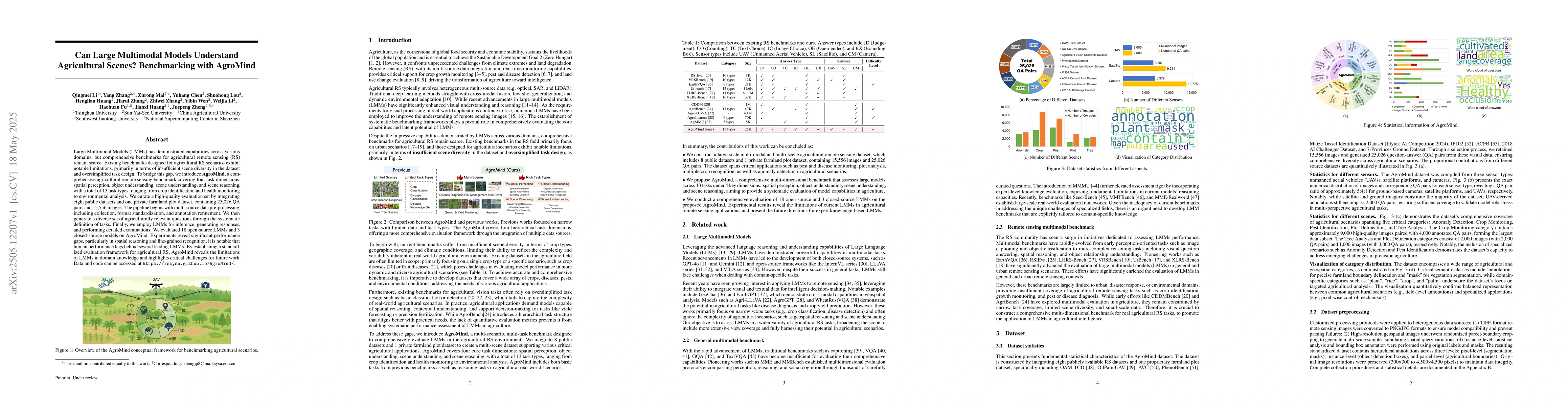
Large Multimodal Models (LMMs) has demonstrated capabilities across various domains, but comprehensive benchmarks for agricultural remote sensing (RS) remain scarce. Existing benchmarks designed for a...

Thumbnail for GTPBD: A Fine-Grained Global Terraced Parcel and Boundary Dataset
arXiv
GTPBD: A Fine-Grained Global Terraced Parcel and Boundary Dataset

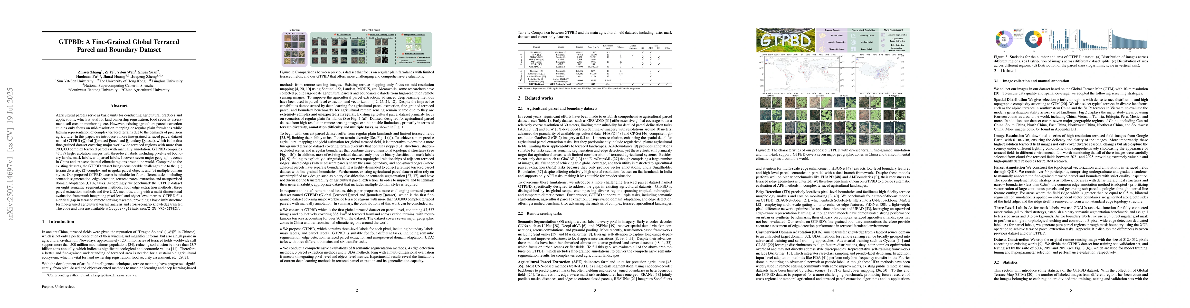
Agricultural parcels serve as basic units for conducting agricultural practices and applications, which is vital for land ownership registration, food security assessment, soil erosion monitoring, etc...

Thumbnail for A Comprehensive Review of Agricultural Parcel and Boundary Delineation
  from Remote Sensing Images: Recent Progress and Future Perspectives
arXiv
A Comprehensive Review of Agricultural Parcel and Boundary Delineation from Remote Sensing Images: Recent Progress and Future Perspectives

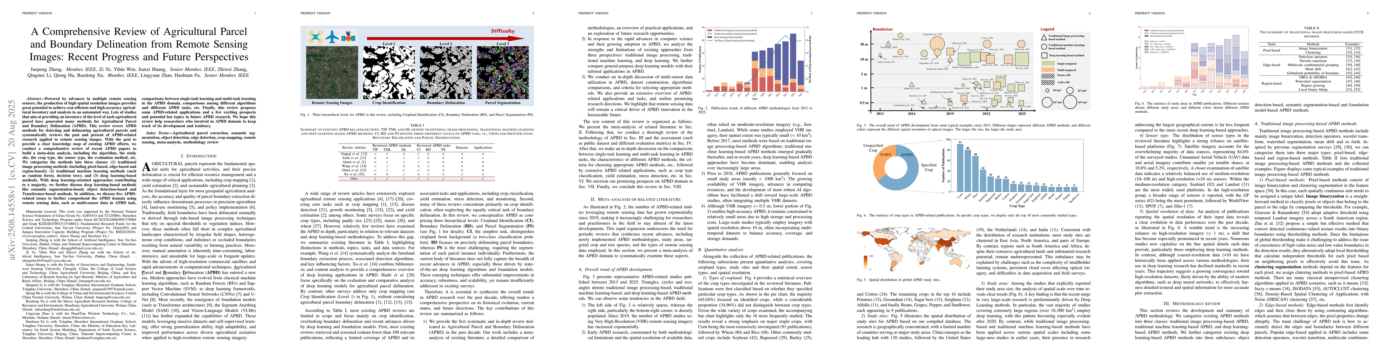
Powered by advances in multiple remote sensing sensors, the production of high spatial resolution images provides great potential to achieve cost-efficient and high-accuracy agricultural inventory and...

Thumbnail for FSG-Net: Frequency-Spatial Synergistic Gated Network for High-Resolution
  Remote Sensing Change Detection
arXiv
FSG-Net: Frequency-Spatial Synergistic Gated Network for High-Resolution Remote Sensing Change Detection

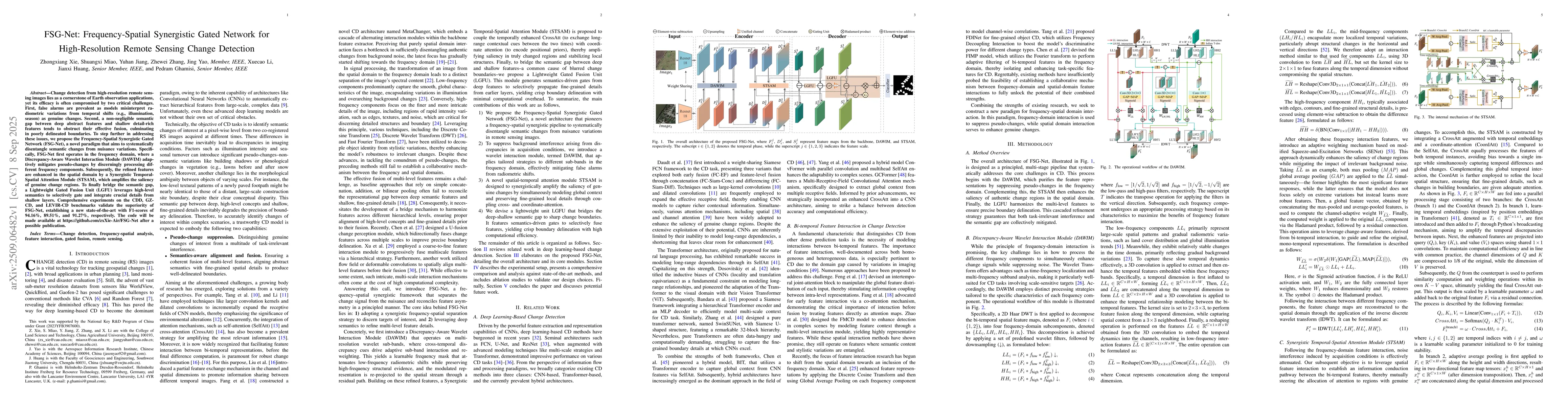
Change detection from high-resolution remote sensing images lies as a cornerstone of Earth observation applications, yet its efficacy is often compromised by two critical challenges. First, false alar...

Thumbnail for AgroNVILA: Perception-Reasoning Decoupling for Multi-view Agricultural Multimodal Large Language Models
arXiv
AgroNVILA: Perception-Reasoning Decoupling for Multi-view Agricultural Multimodal Large Language Models

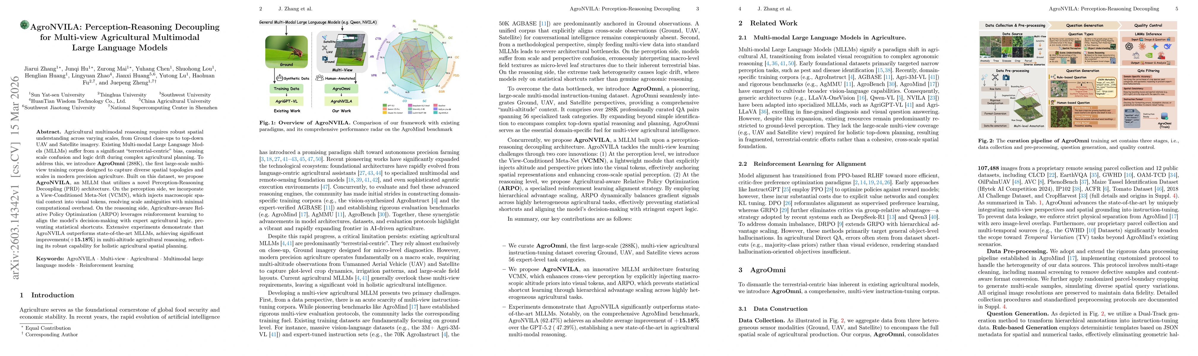
Agricultural multimodal reasoning requires robust spatial understanding across varying scales, from ground-level close-ups to top-down UAV and satellite imagery. Existing Multi-modal Large Language Mo...

Thumbnail for Parameter-Efficient Modality-Balanced Symmetric Fusion for Multimodal Remote Sensing Semantic Segmentation
arXiv
Parameter-Efficient Modality-Balanced Symmetric Fusion for Multimodal Remote Sensing Semantic Segmentation

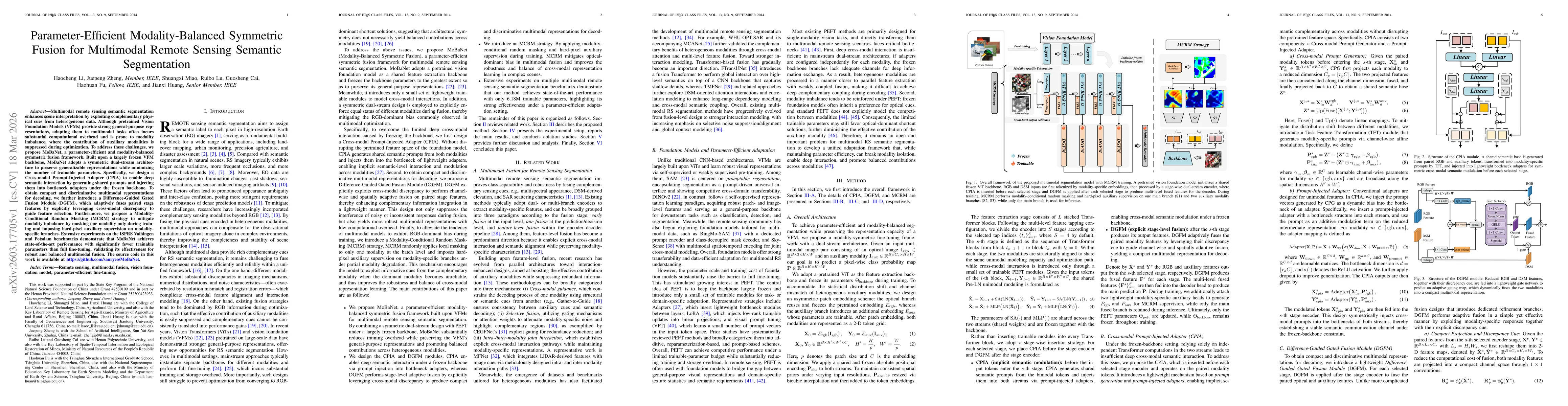
Multimodal remote sensing semantic segmentation enhances scene interpretation by exploiting complementary physical cues from heterogeneous data. Although pretrained Vision Foundation Models (VFMs) pro...

Thumbnail for HM-Bench: A Comprehensive Benchmark for Multimodal Large Language Models in Hyperspectral Remote Sensing
arXiv
HM-Bench: A Comprehensive Benchmark for Multimodal Large Language Models in Hyperspectral Remote Sensing

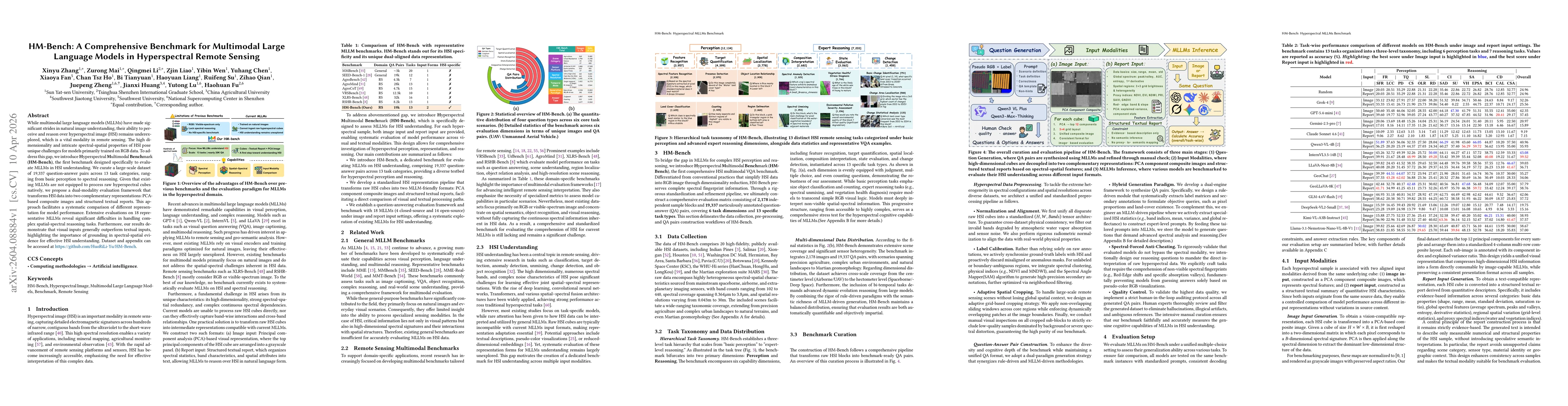
While multimodal large language models (MLLMs) have made significant strides in natural image understanding, their ability to perceive and reason over hyperspectral image (HSI) remains underexplored, ...

Thumbnail for GTPBD-MM: A Global Terraced Parcel and Boundary Dataset with Multi-Modality
arXiv
GTPBD-MM: A Global Terraced Parcel and Boundary Dataset with Multi-Modality

Agricultural parcel extraction plays an important role in remote sensing-based agricultural monitoring, supporting parcel surveying, precision management, and ecological assessment. However, existing ...

Thumbnail for AgroVG: A Large-Scale Multi-Source Benchmark for Agricultural Visual Grounding
arXiv
AgroVG: A Large-Scale Multi-Source Benchmark for Agricultural Visual Grounding

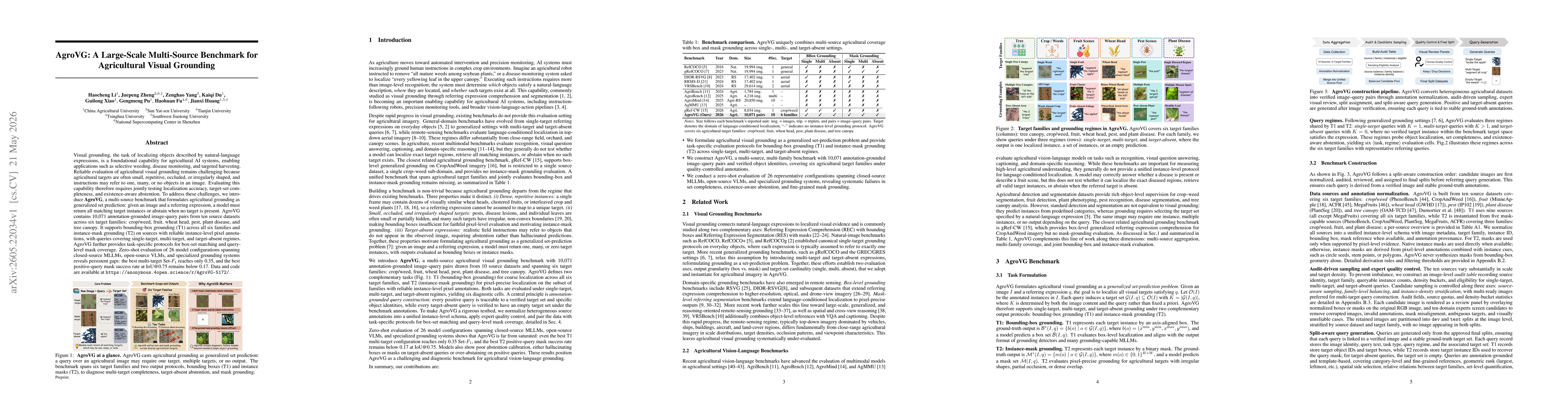
Visual grounding, the task of localizing objects described by natural-language expressions, is a foundational capability for agricultural AI systems, enabling applications such as selective weeding, d...

Thumbnail for AgroTools: A Benchmark for Tool-Augmented Multimodal Agents in Agriculture
arXiv
AgroTools: A Benchmark for Tool-Augmented Multimodal Agents in Agriculture

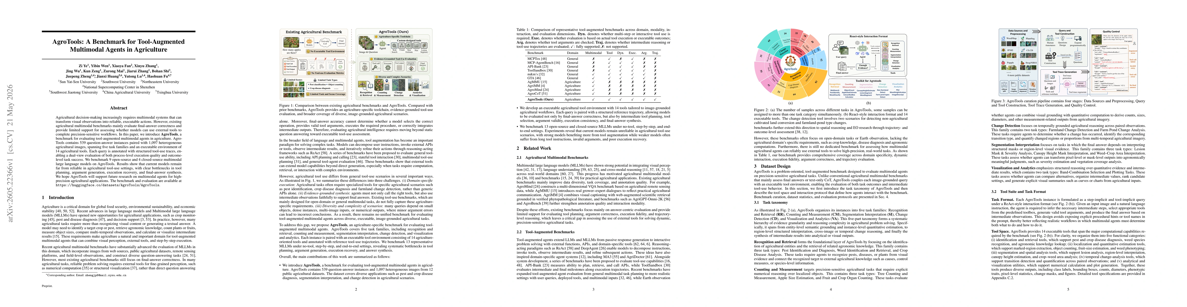
Agricultural decision-making increasingly requires multimodal systems that can transform visual observations into reliable, executable actions. However, existing agricultural multimodal benchmarks mai...

This website uses cookies to ensure you get the best experience. Learn more