Academic Profile
Statistics
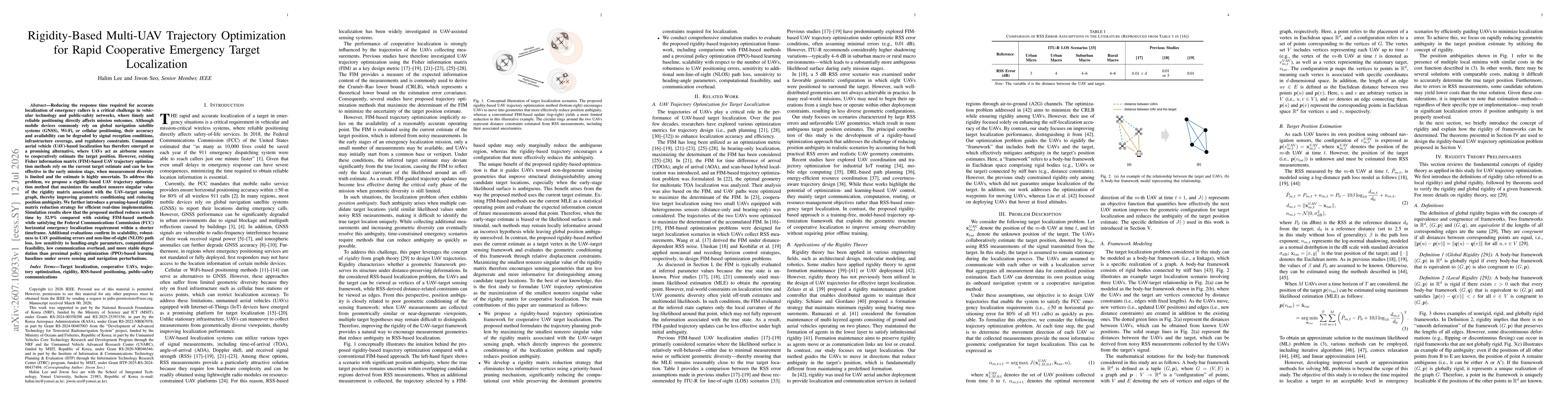
Similar Authors
Papers on arXiv
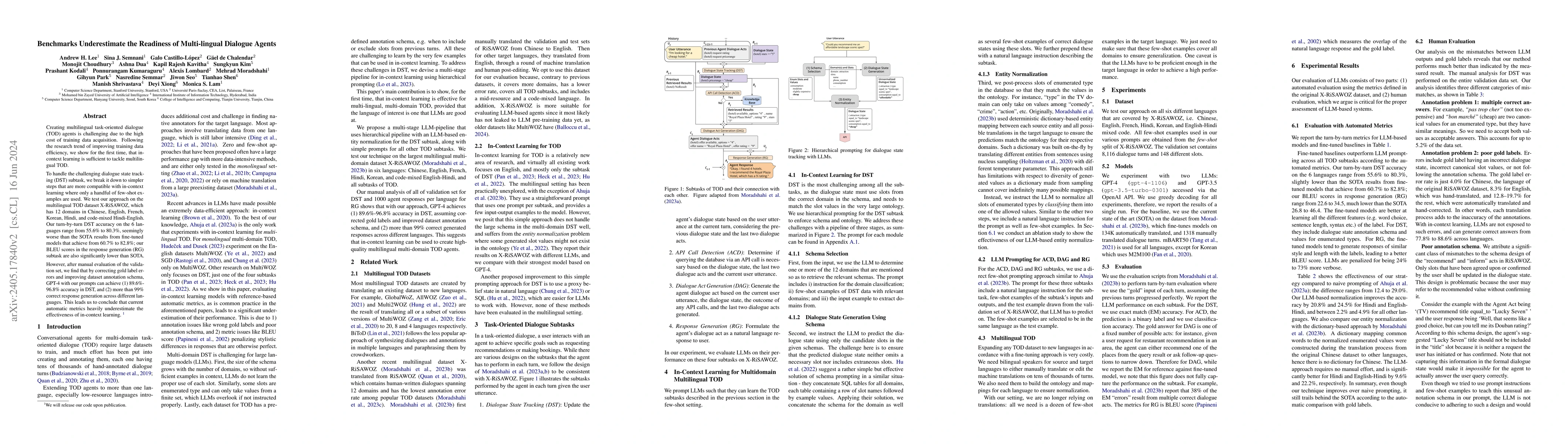
Creating multilingual task-oriented dialogue (TOD) agents is challenging due to the high cost of training data acquisition. Following the research trend of improving training data efficiency, we show ...
Quantum computing holds the potential to solve problems that are practically unsolvable by classical computers due to its ability to significantly reduce time complexity. We aim to harness this pote...
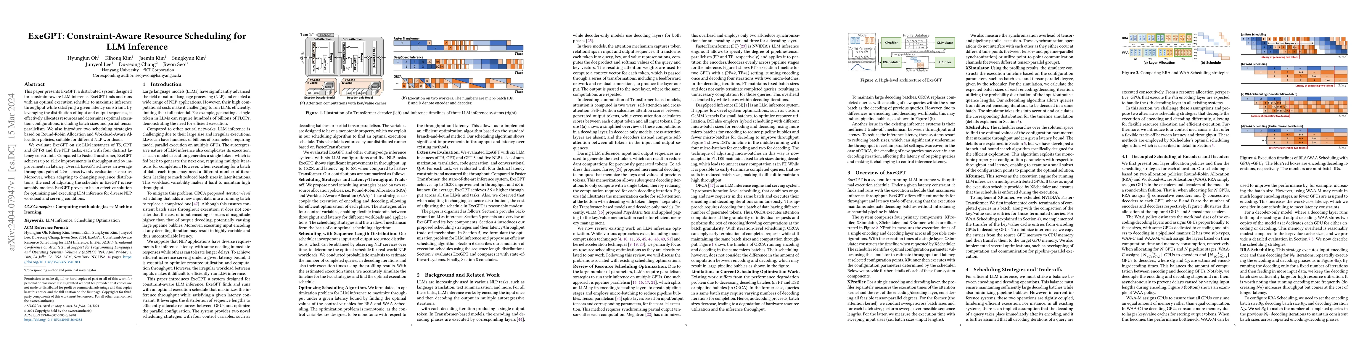
This paper presents ExeGPT, a distributed system designed for constraint-aware LLM inference. ExeGPT finds and runs with an optimal execution schedule to maximize inference throughput while satisfyi...
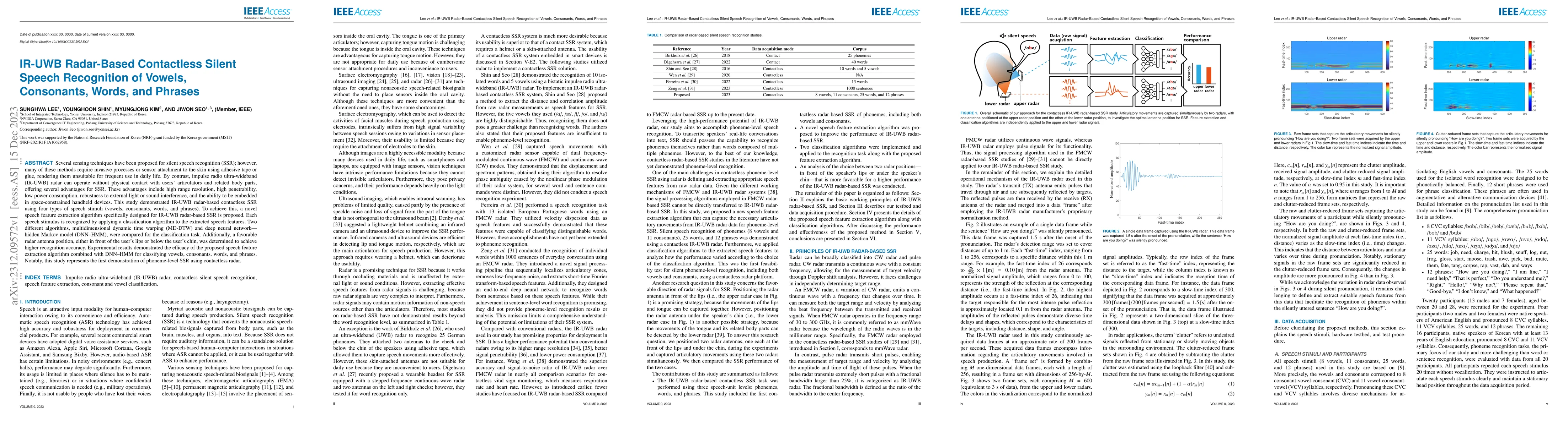
Several sensing techniques have been proposed for silent speech recognition (SSR); however, many of these methods require invasive processes or sensor attachment to the skin using adhesive tape or g...
Task-oriented dialogue research has mainly focused on a few popular languages like English and Chinese, due to the high dataset creation cost for a new language. To reduce the cost, we apply manual ...
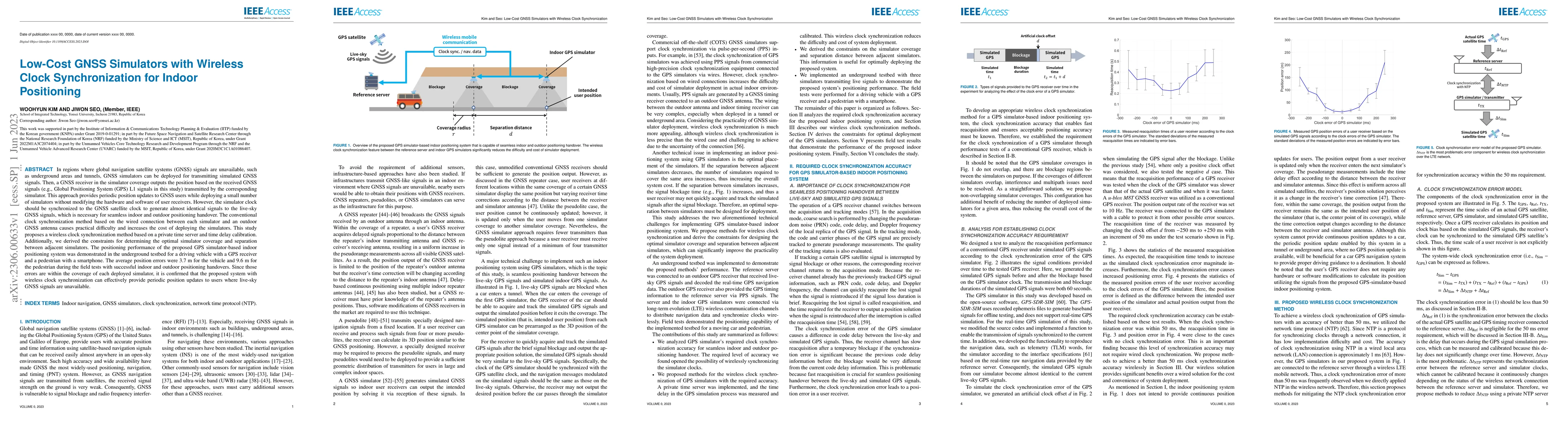
In regions where global navigation satellite systems (GNSS) signals are unavailable, such as underground areas and tunnels, GNSS simulators can be deployed for transmitting simulated GNSS signals. T...
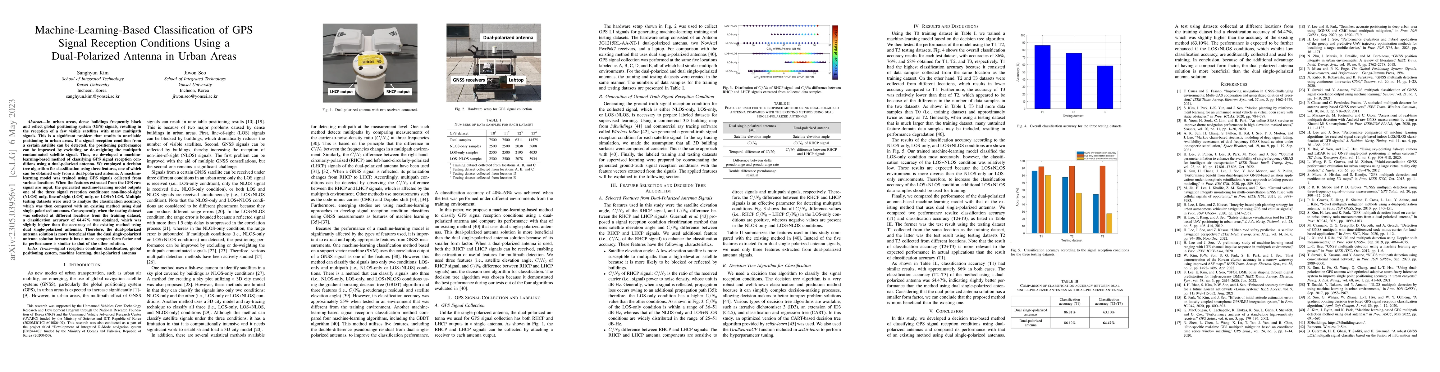
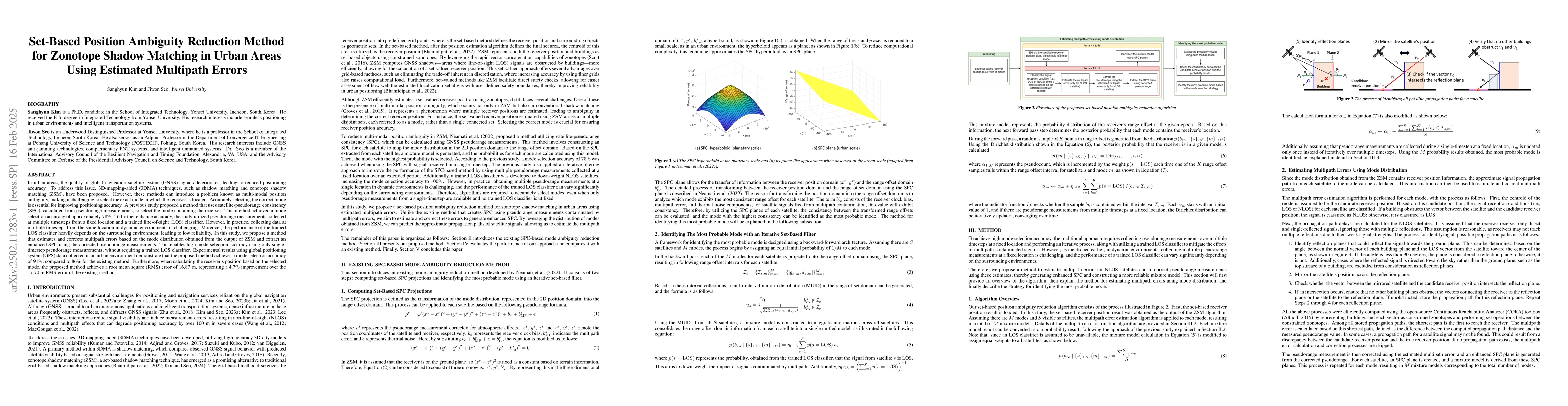
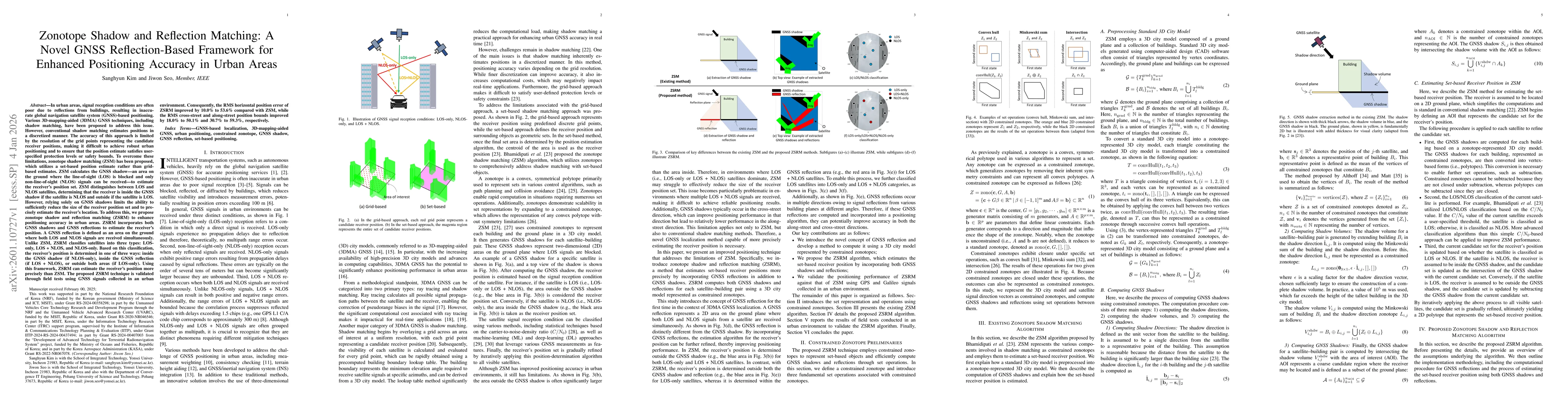
In urban areas, dense buildings frequently block and reflect global positioning system (GPS) signals, resulting in the reception of a few visible satellites with many multipath signals. This is a si...
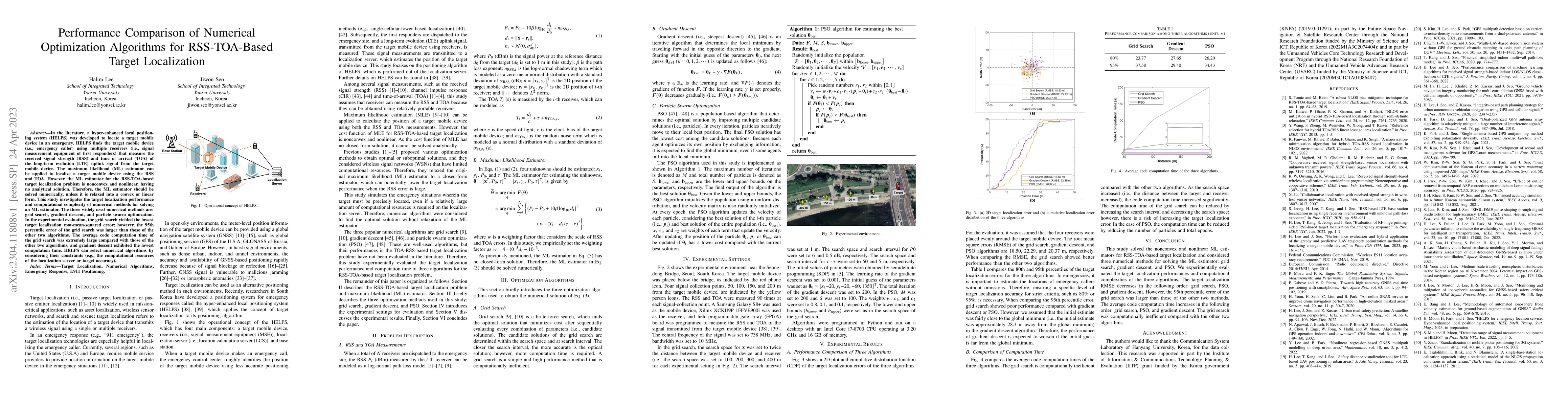
The maximum likelihood (ML) estimator can be applied to localize a target mobile device using the RSS and TOA. However, the ML estimator for the RSS-TOA-based target localization problem is nonconve...
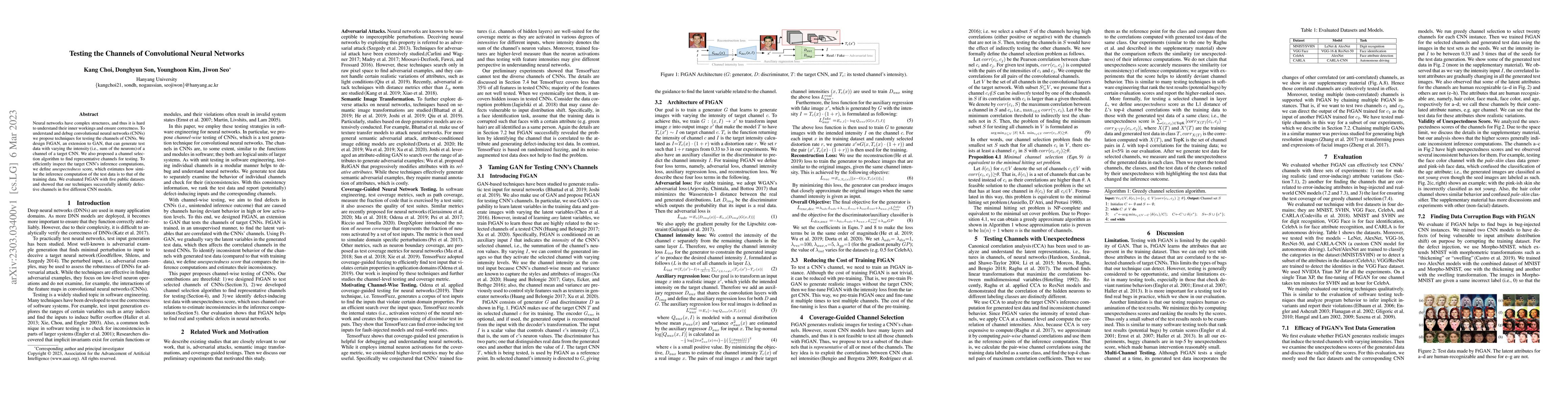
Neural networks have complex structures, and thus it is hard to understand their inner workings and ensure correctness. To understand and debug convolutional neural networks (CNNs) we propose techni...
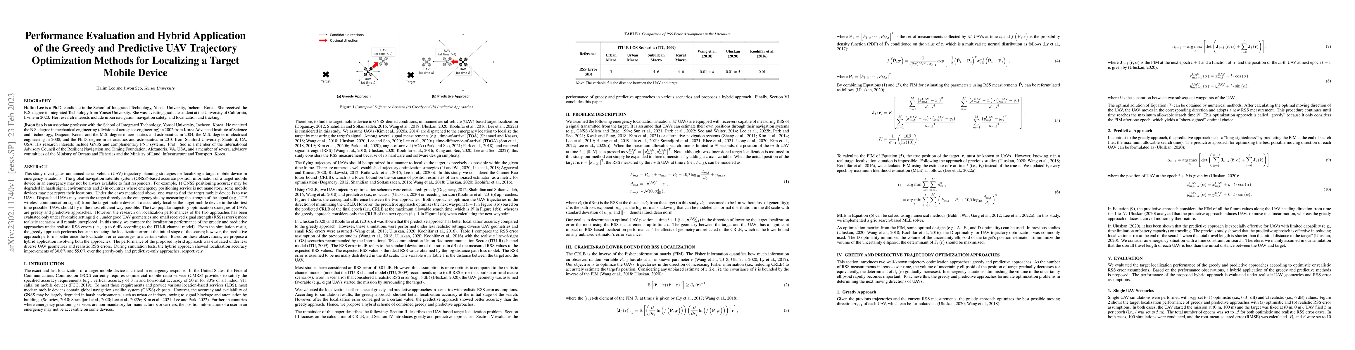
This study investigates unmanned aerial vehicle (UAV) trajectory planning strategies for localizing a target mobile device in emergency situations. The global navigation satellite system (GNSS)-base...
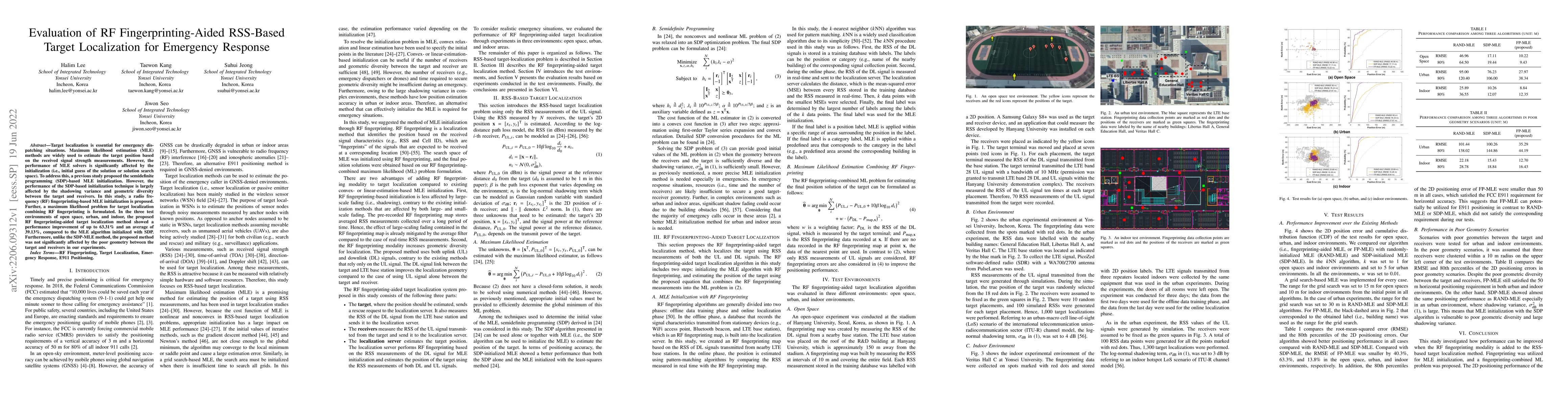
Target localization is essential for emergency dispatching situations. Maximum likelihood estimation (MLE) methods are widely used to estimate the target position based on the received signal streng...
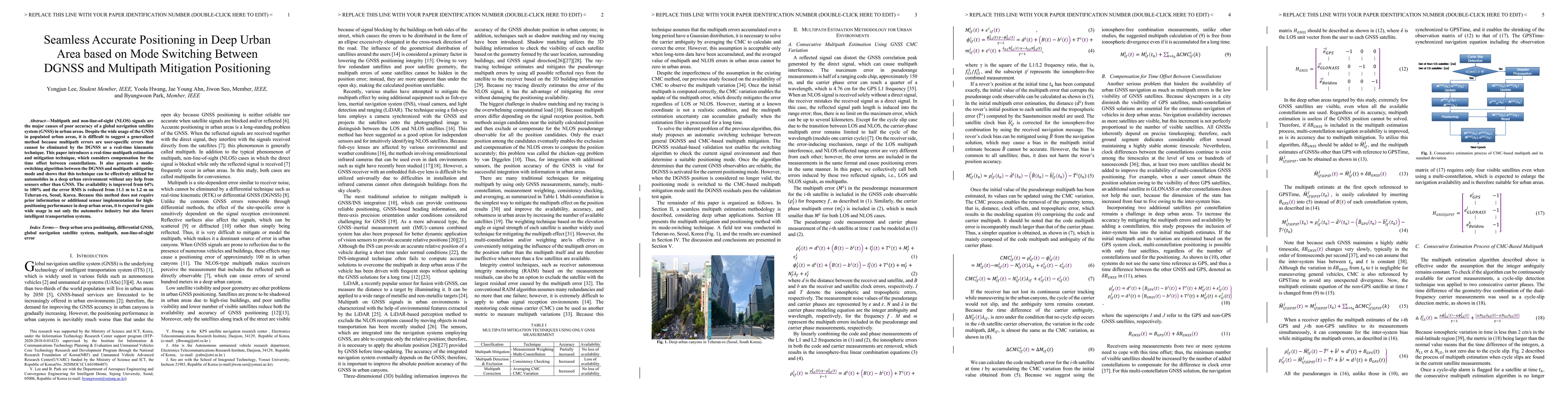
Multipath and non-line-of-sight (NLOS) signals are the major causes of poor accuracy of a global navigation satellite system (GNSS) in urban areas. Despite the wide usage of the GNSS in populated ur...
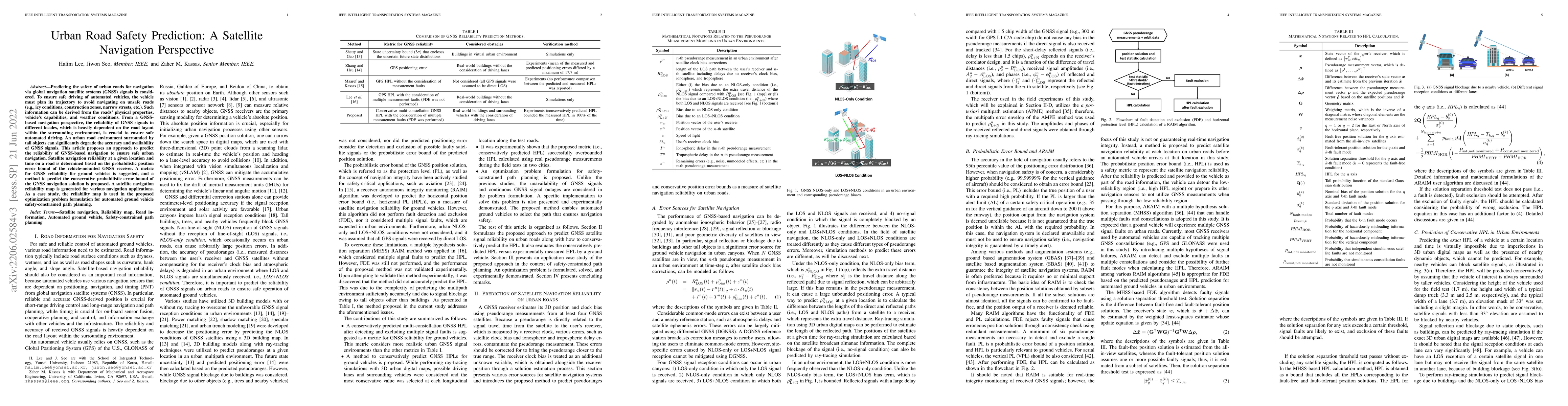
Predicting the safety of urban roads for navigation via global navigation satellite systems (GNSS) signals is considered. To ensure safe driving of automated vehicles, the vehicle must plan its traj...
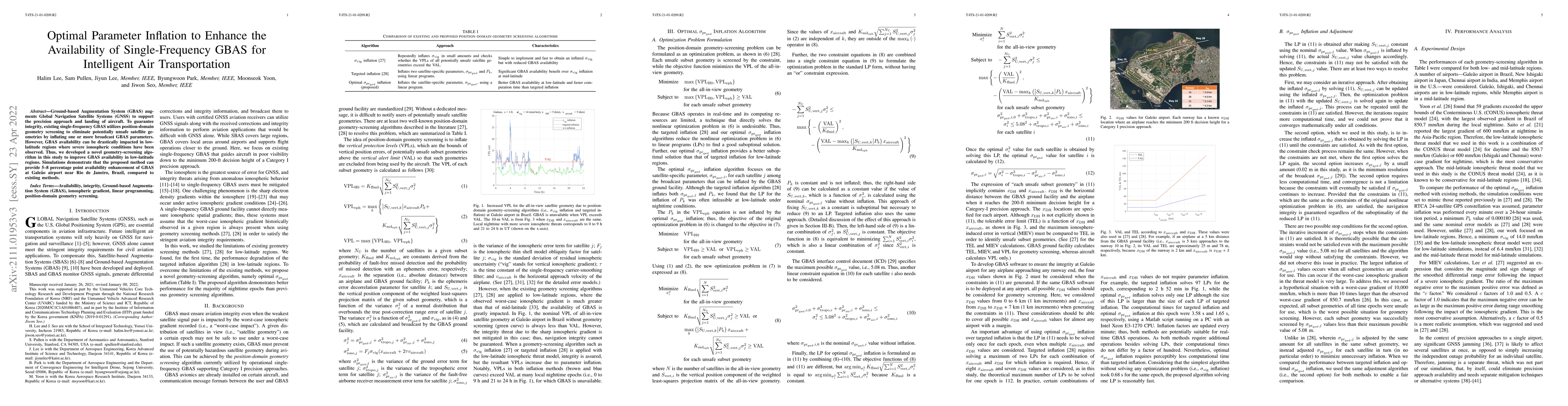
Ground-based Augmentation System (GBAS) augments Global Navigation Satellite Systems (GNSS) to support the precision approach and landing of aircraft. To guarantee integrity, existing single-frequen...
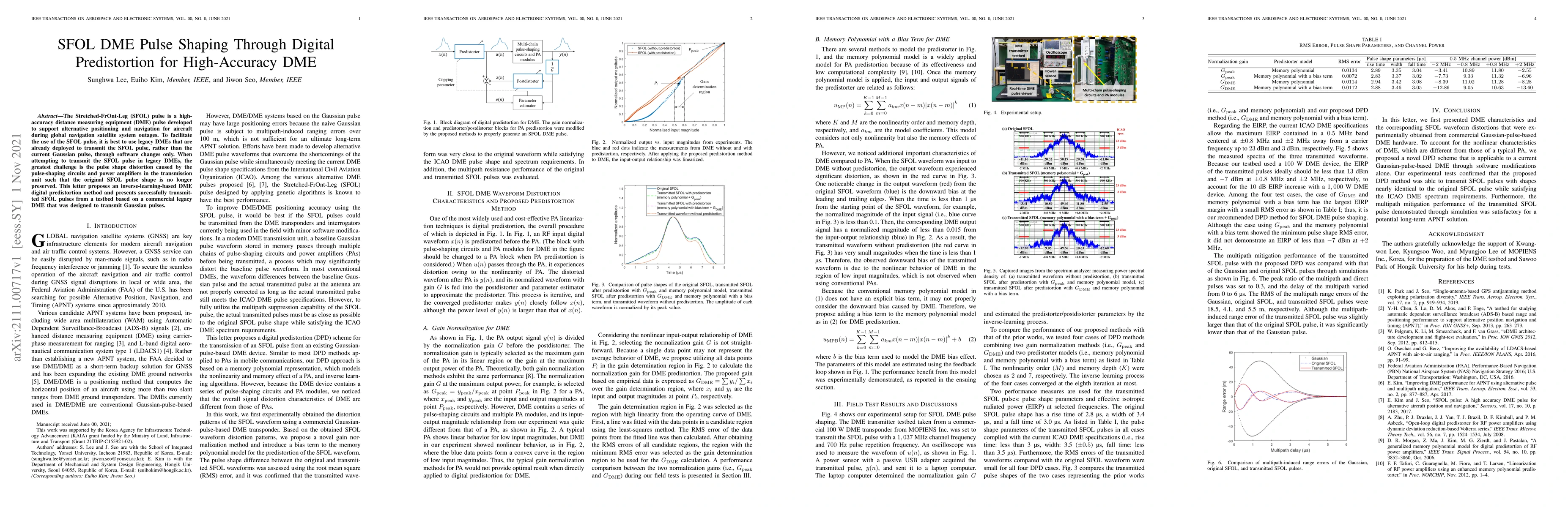
The Stretched-FrOnt-Leg (SFOL) pulse is a high-accuracy distance measuring equipment (DME) pulse developed to support alternative positioning and navigation for aircraft during global navigation sat...
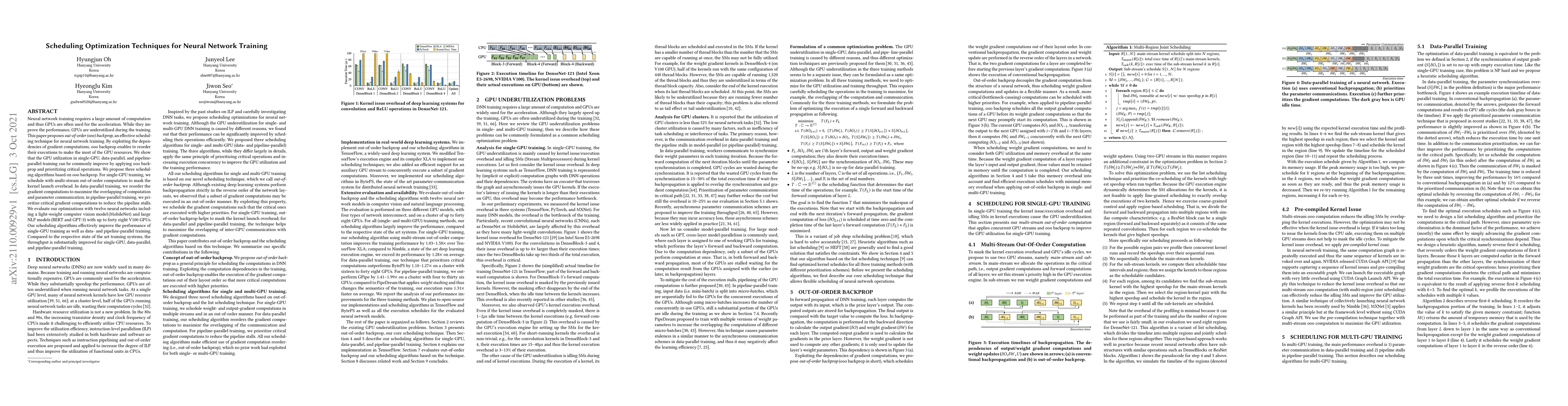
Neural network training requires a large amount of computation and thus GPUs are often used for the acceleration. While they improve the performance, GPUs are underutilized during the training.This ...
The Global Positioning System (GPS) has become the most widely used positioning, navigation, and timing system. However, the vulnerability of GPS to radio frequency interference has attracted signif...
The recently advanced robotics technology enables robots to assist users in their daily lives. Haptic guidance (HG) improves users' task performance through physical interaction between robots and u...
With the increasing demand for location-based services, localization technology research has recently intensified. Received signal strength (RSS)-based localization has the advantage of simplicity. ...
Alternative navigation technology to global navigation satellite systems (GNSSs) is required for unmanned ground vehicles (UGVs) in multipath environments (such as urban areas). In urban areas, long...
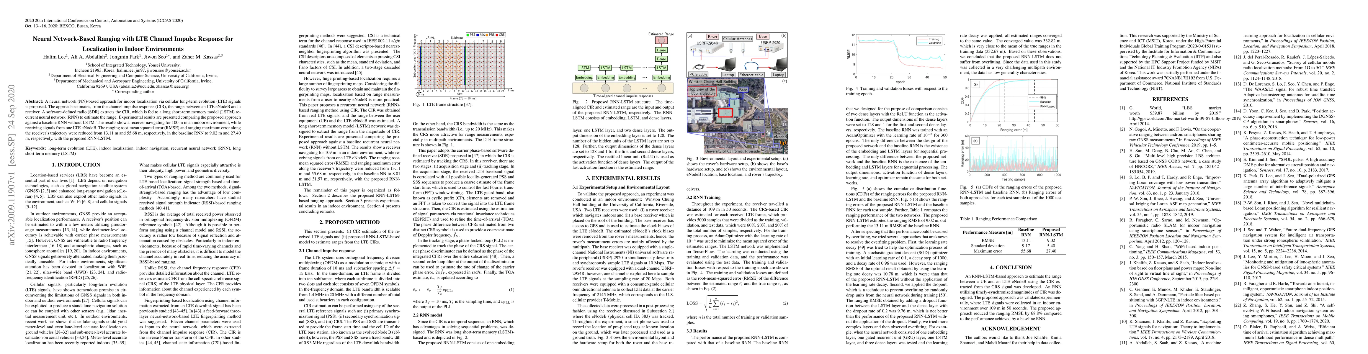
A neural network (NN)-based approach for indoor localization via cellular long-term evolution (LTE) signals is proposed. The approach estimates, from the channel impulse response (CIR), the range be...
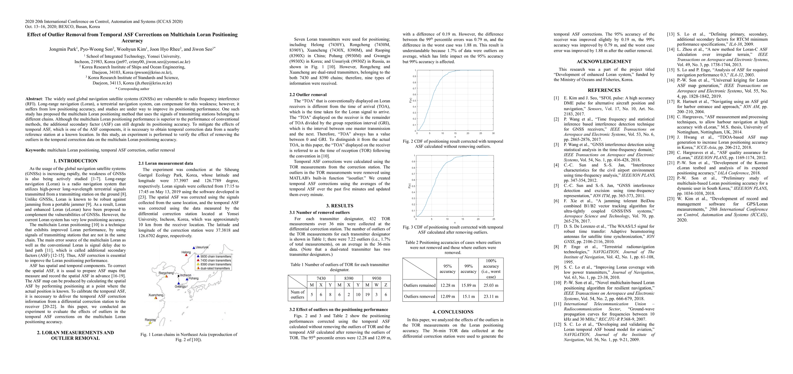
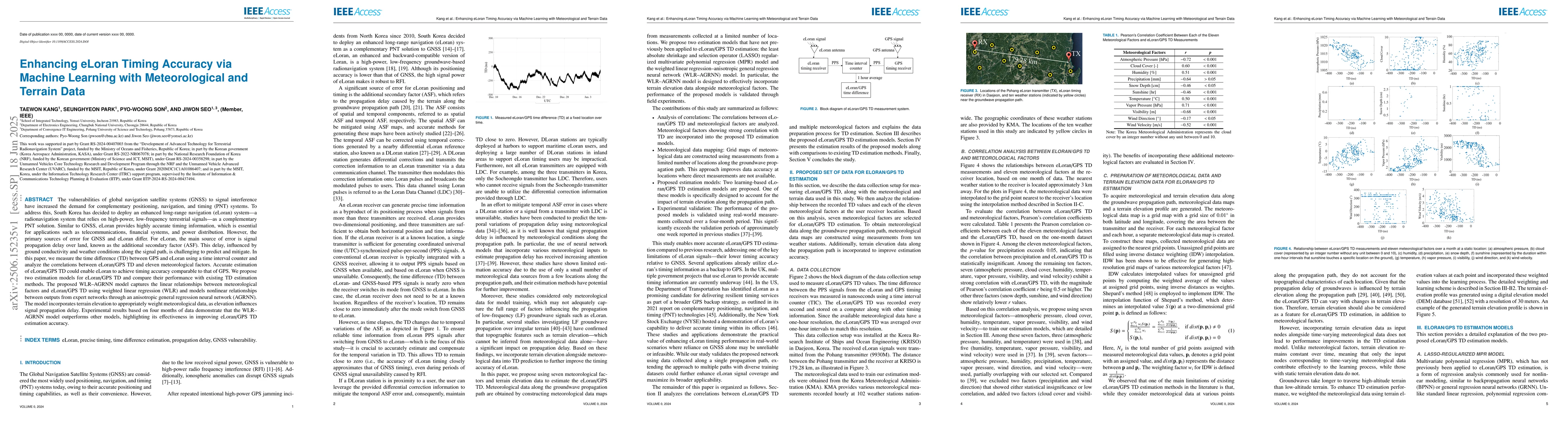
The widely used global navigation satellite systems (GNSSs) are vulnerable to radio frequency interference (RFI). Long-range navigation (Loran), a terrestrial navigation system, can compensate for t...
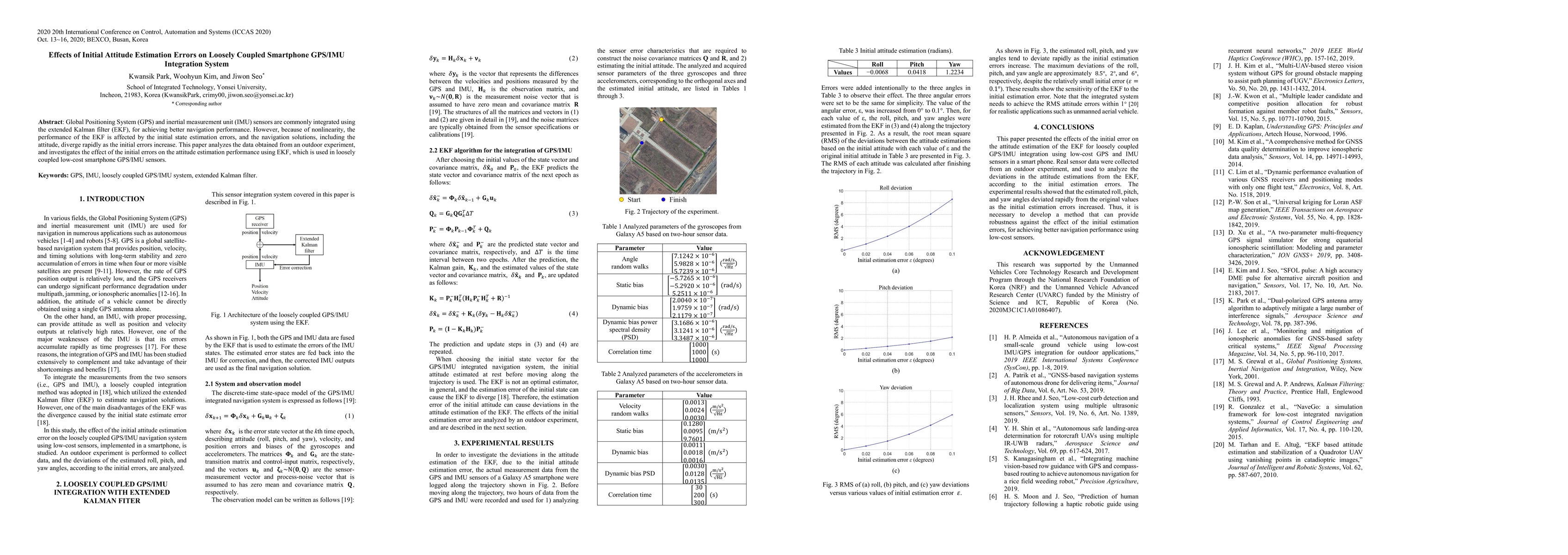
Global Positioning System (GPS) and inertial measurement unit (IMU) sensors are commonly integrated using the extended Kalman filter (EKF), for achieving better navigation performance. However, beca...
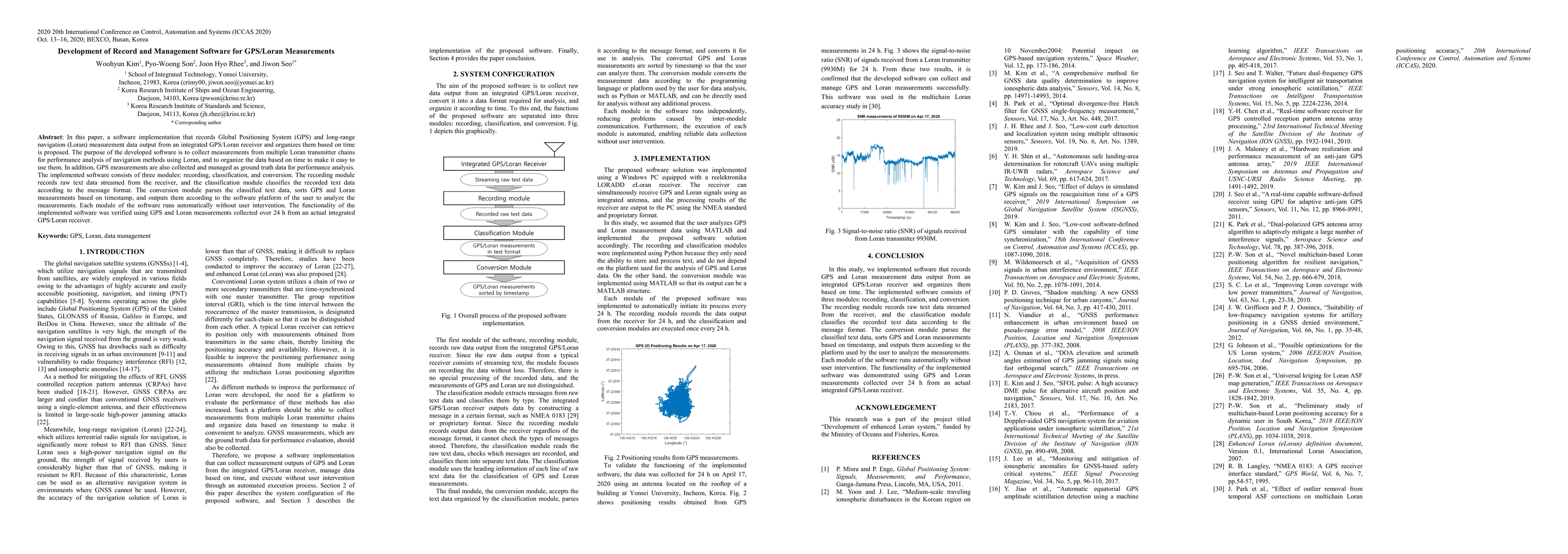
In this paper, a software implementation that records Global Positioning System (GPS) and long-range navigation (Loran) measurement data output from an integrated GPS/Loran receiver and organizes th...
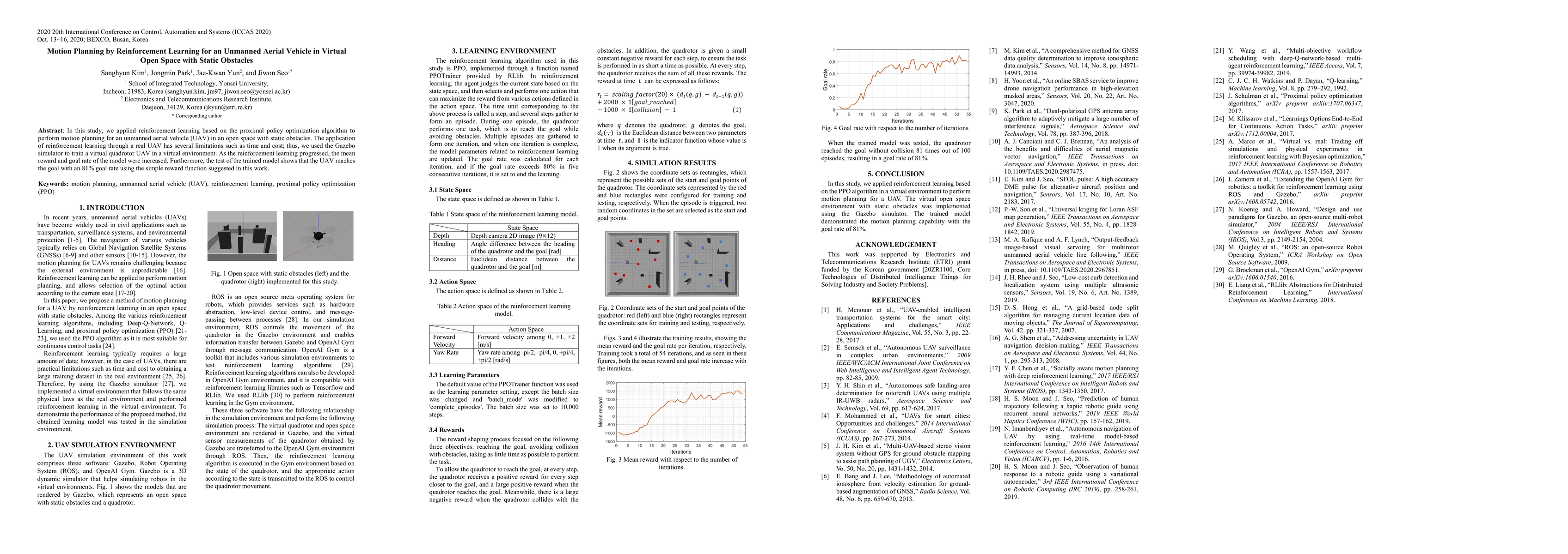
In this study, we applied reinforcement learning based on the proximal policy optimization algorithm to perform motion planning for an unmanned aerial vehicle (UAV) in an open space with static obst...
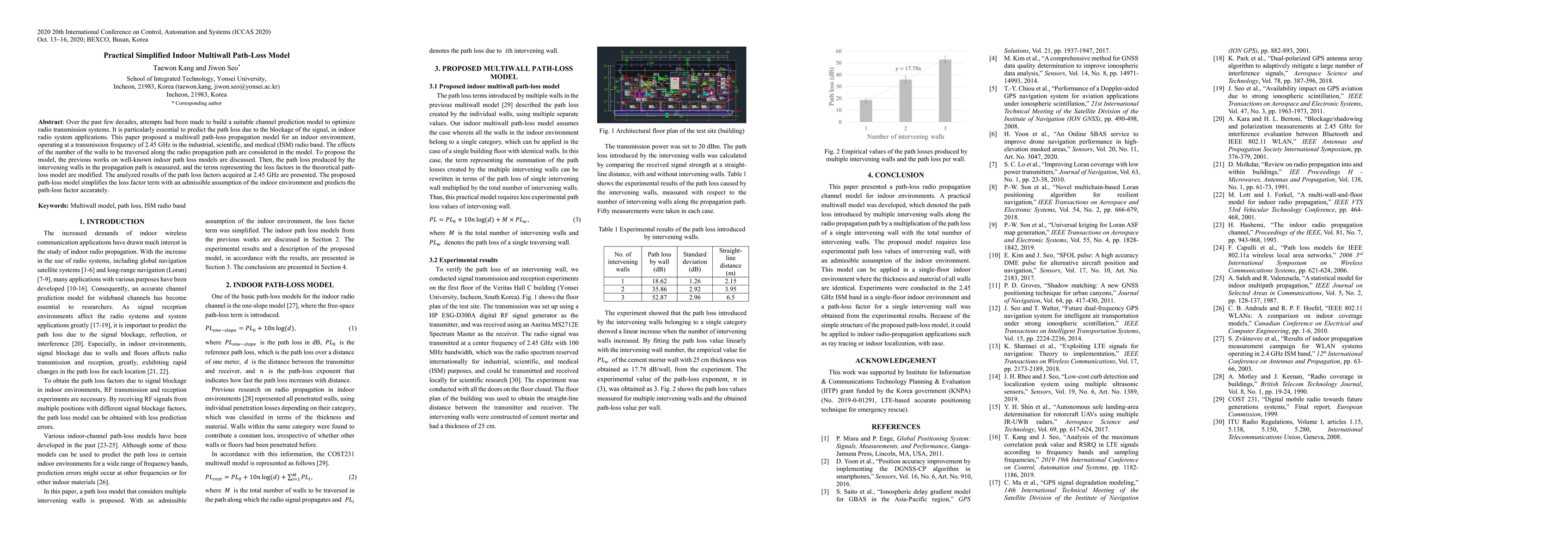
Over the past few decades, attempts had been made to build a suitable channel prediction model to optimize radio transmission systems. It is particularly essential to predict the path loss due to th...
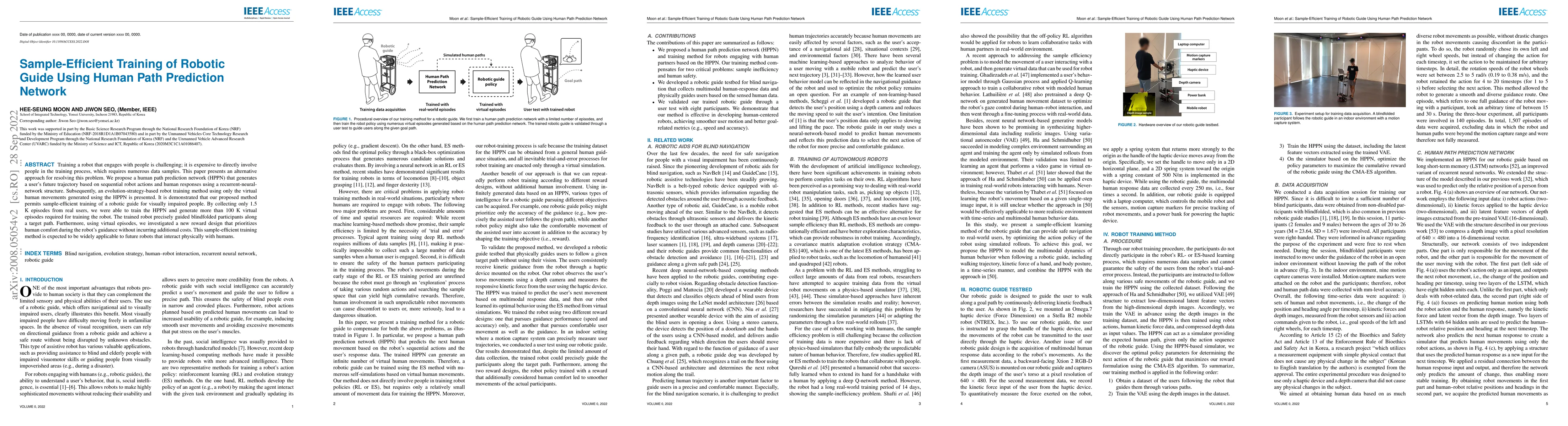
Training a robot that engages with people is challenging; it is expensive to directly involve people in the training process, which requires numerous data samples. This paper presents an alternative...
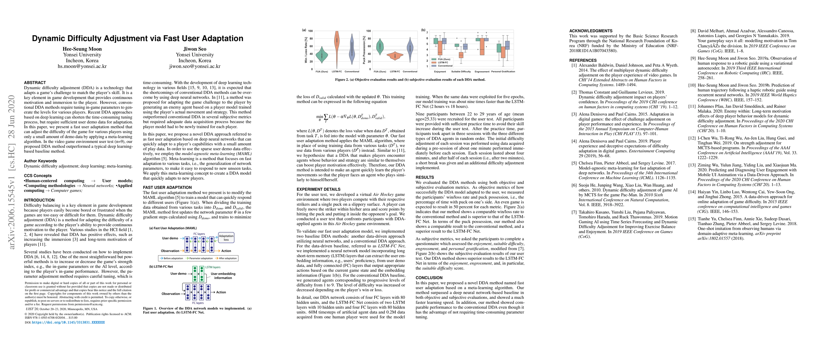
Dynamic difficulty adjustment (DDA) is a technology that adapts a game's challenge to match the player's skill. It is a key element in game development that provides continuous motivation and immers...
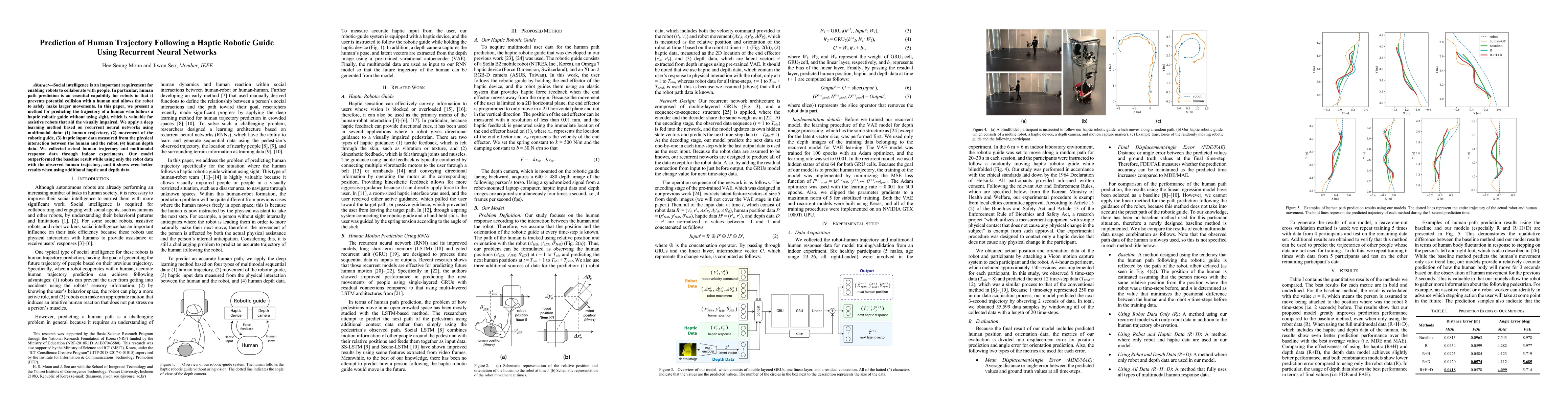
Social intelligence is an important requirement for enabling robots to collaborate with people. In particular, human path prediction is an essential capability for robots in that it prevents potenti...
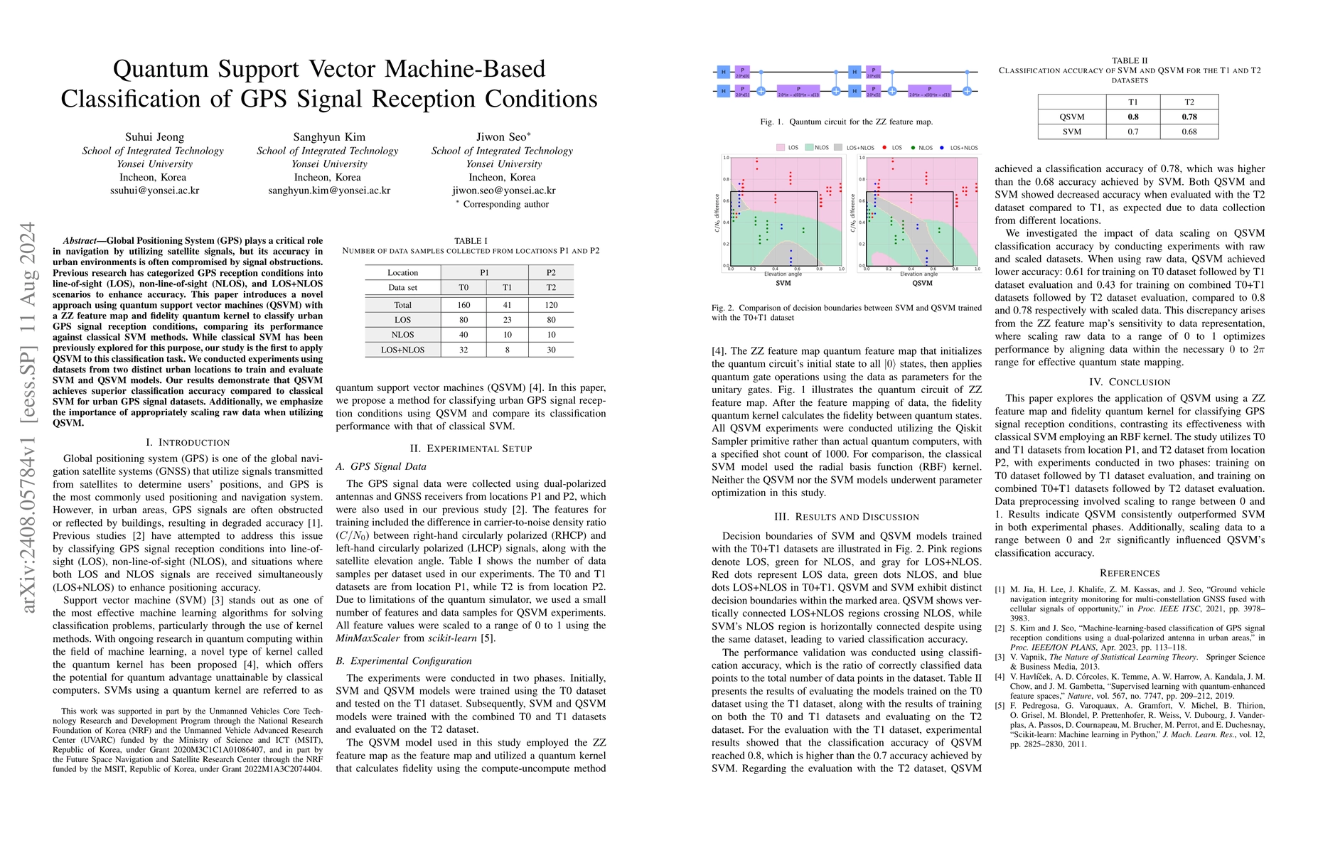
Global Positioning System (GPS) plays a critical role in navigation by utilizing satellite signals, but its accuracy in urban environments is often compromised by signal obstructions. Previous researc...
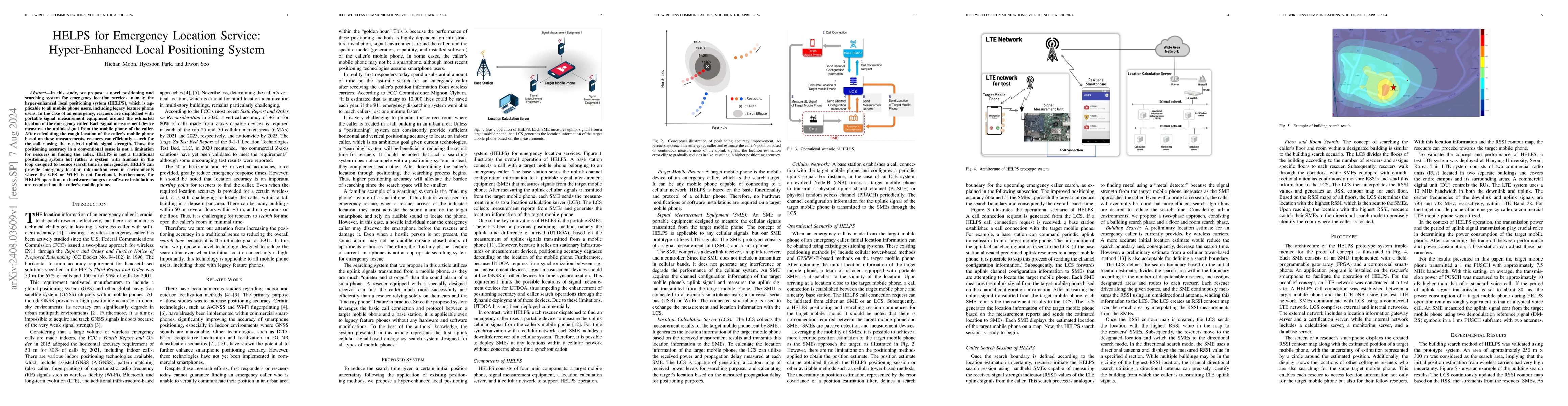
In this study, we propose a novel positioning and searching system for emergency location services, namely the hyper-enhanced local positioning system (HELPS), which is applicable to all mobile phone ...
In urban areas, the quality of global navigation satellite system (GNSS) signals deteriorates, leading to reduced positioning accuracy. To address this issue, 3D-mapping-aided (3DMA) techniques, such ...
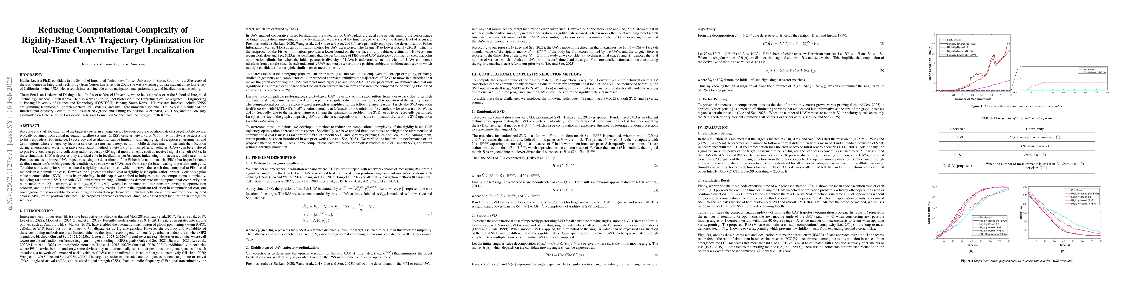
Accurate and swift localization of the target is crucial in emergencies. However, accurate position data of a target mobile device, typically obtained from global navigation satellite systems (GNSS), ...
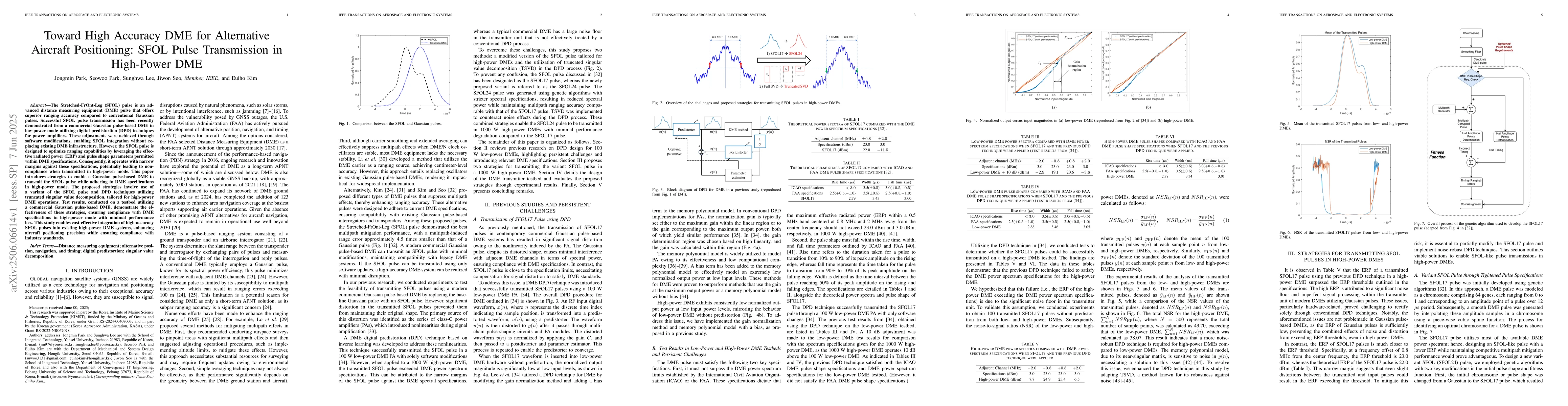
The Stretched-FrOnt-Leg (SFOL) pulse is an advanced distance measuring equipment (DME) pulse that offers superior ranging accuracy compared to conventional Gaussian pulses. Successful SFOL pulse trans...
The vulnerabilities of global navigation satellite systems (GNSS) to signal interference have increased the demand for complementary positioning, navigation, and timing (PNT) systems. To address this,...
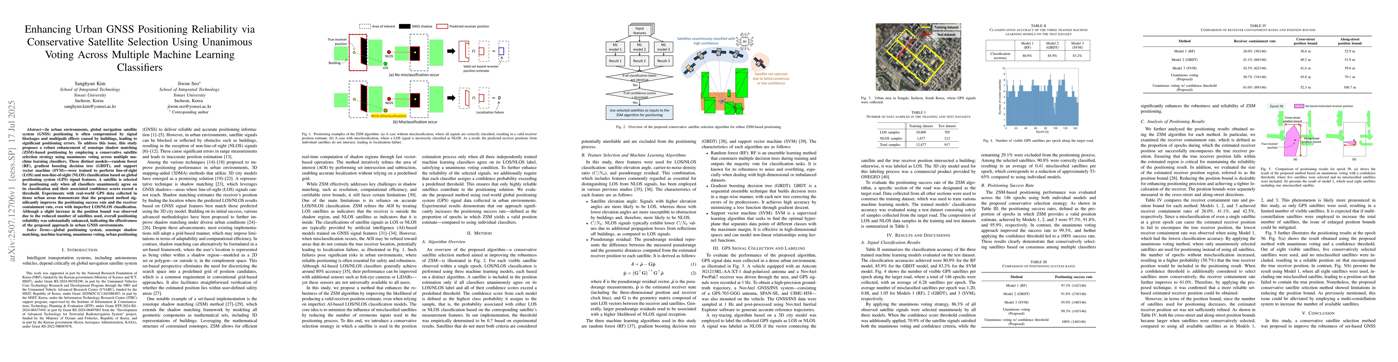
In urban environments, global navigation satellite system (GNSS) positioning is often compromised by signal blockages and multipath effects caused by buildings, leading to significant positioning erro...
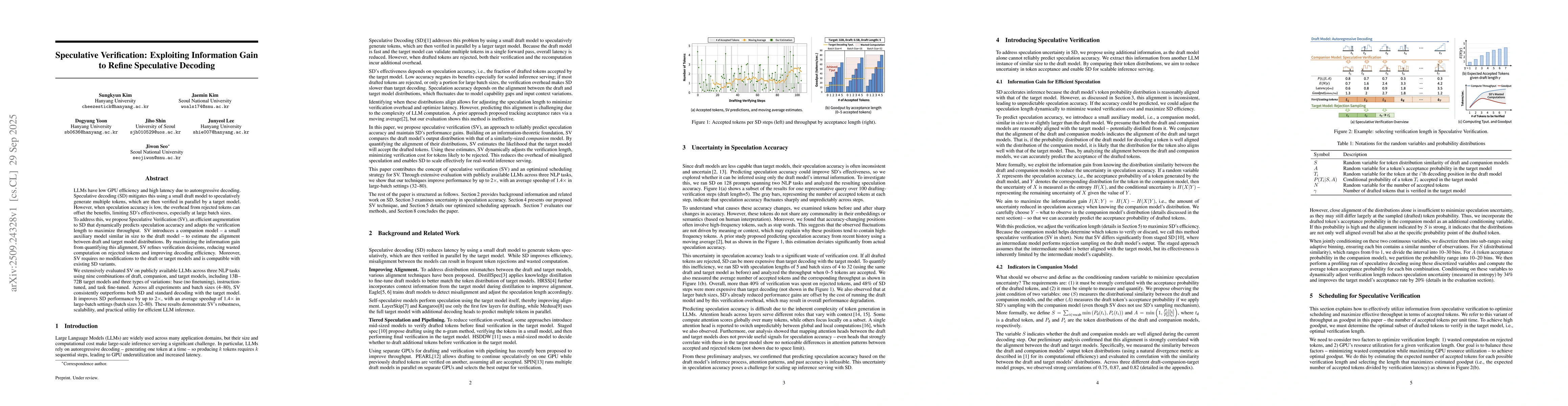
LLMs have low GPU efficiency and high latency due to autoregressive decoding. Speculative decoding (SD) mitigates this using a small draft model to speculatively generate multiple tokens, which are th...
Neural networks commonly execute on hardware accelerators such as NPUs and GPUs for their size and computation overhead. These accelerators are costly and it is hard to scale their resources to handle...
In urban areas, signal reception conditions are often poor due to reflections from buildings, resulting in inaccurate global navigation satellite system (GNSS)-based positioning. Various 3D-mapping-ai...
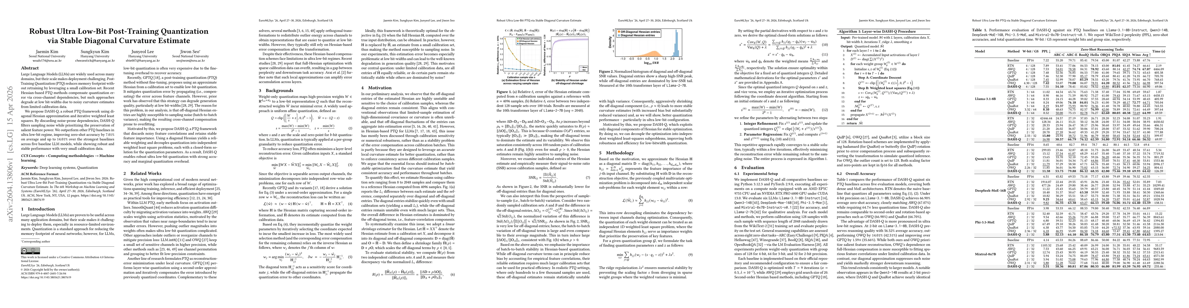
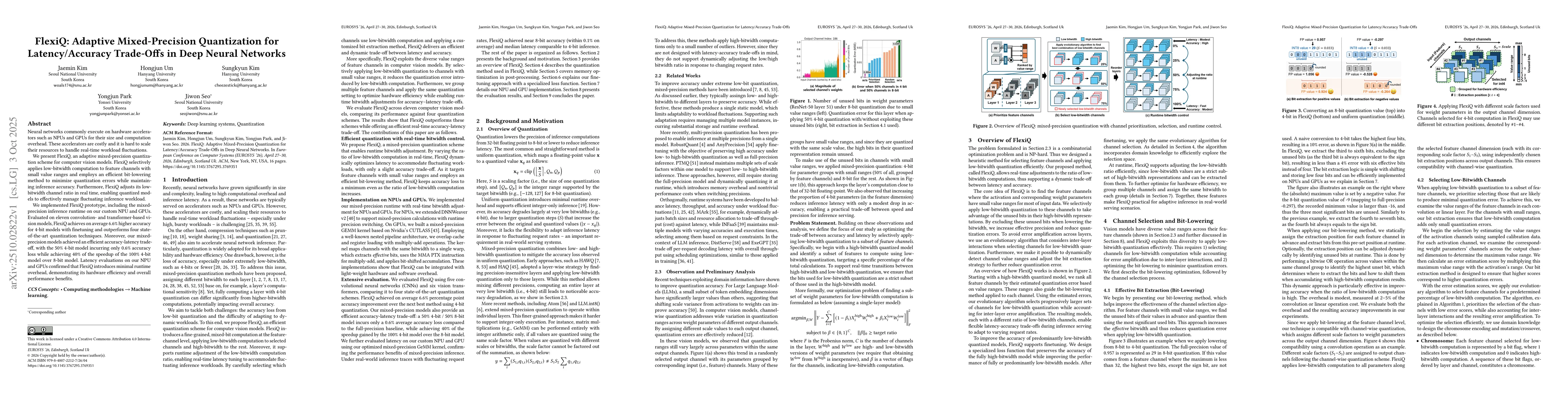
Large Language Models (LLMs) are widely used across many domains, but their scale makes deployment challenging. Post-Training Quantization (PTQ) reduces memory footprint without retraining by leveragi...
Reducing the response time for accurate emergency-caller localization is critical in vehicular and public-safety networks. Although mobile devices commonly use GNSS, Wi-Fi, or cellular positioning, th...