ArxivLens
L
Researcher

Liheng Zhong

7 papers on arXiv

7 arXiv Papers
15 Total Publications
Profile

Academic Profile

Name Lihe Zhong
Total Papers 15
Scholar Profile View on Semantic Scholar
Metrics

Statistics

7 arXiv Papers
15 Total Publications
Publications

Papers on arXiv

Thumbnail for SkySense: A Multi-Modal Remote Sensing Foundation Model Towards
  Universal Interpretation for Earth Observation Imagery
arXiv
SkySense: A Multi-Modal Remote Sensing Foundation Model Towards Universal Interpretation for Earth Observation Imagery

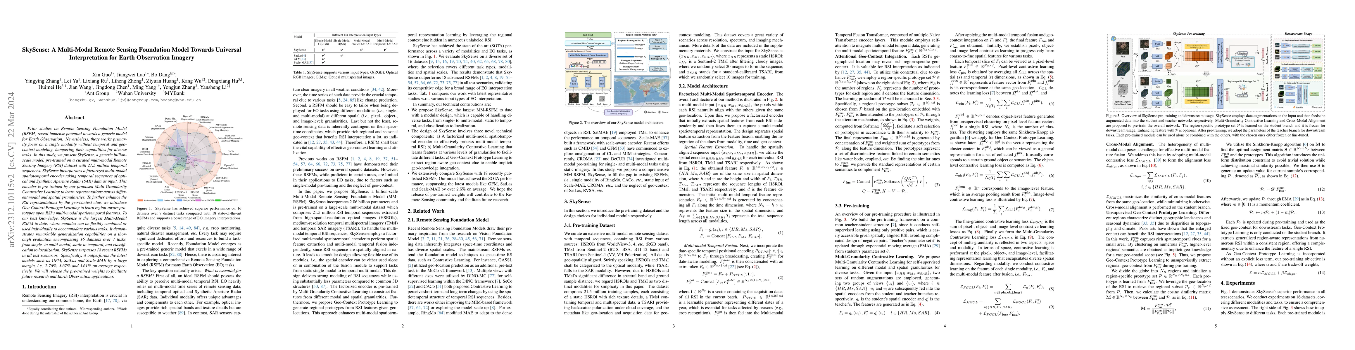
Prior studies on Remote Sensing Foundation Model (RSFM) reveal immense potential towards a generic model for Earth Observation. Nevertheless, these works primarily focus on a single modality without...

Thumbnail for Early- and in-season crop type mapping without current-year ground
  truth: generating labels from historical information via a topology-based
  approach
arXiv
Early- and in-season crop type mapping without current-year ground truth: generating labels from historical information via a topology-based approach

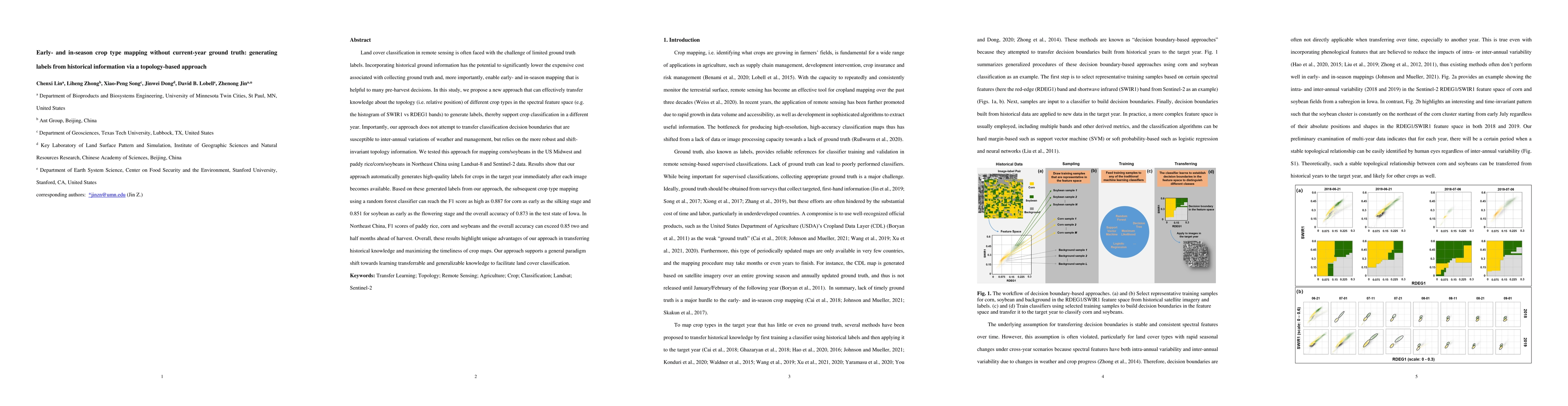
Land cover classification in remote sensing is often faced with the challenge of limited ground truth. Incorporating historical information has the potential to significantly lower the expensive cos...

Thumbnail for HomoMatcher: Dense Feature Matching Results with Semi-Dense Efficiency
  by Homography Estimation
arXiv
HomoMatcher: Dense Feature Matching Results with Semi-Dense Efficiency by Homography Estimation

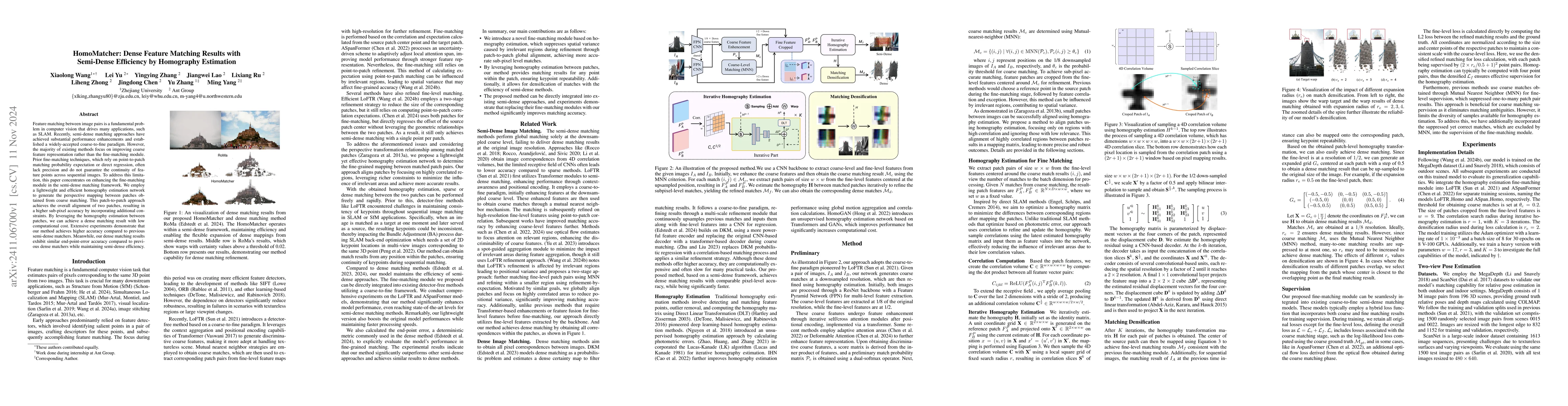
Feature matching between image pairs is a fundamental problem in computer vision that drives many applications, such as SLAM. Recently, semi-dense matching approaches have achieved substantial perform...

Thumbnail for Cross-View Image Set Geo-Localization
arXiv
Cross-View Image Set Geo-Localization

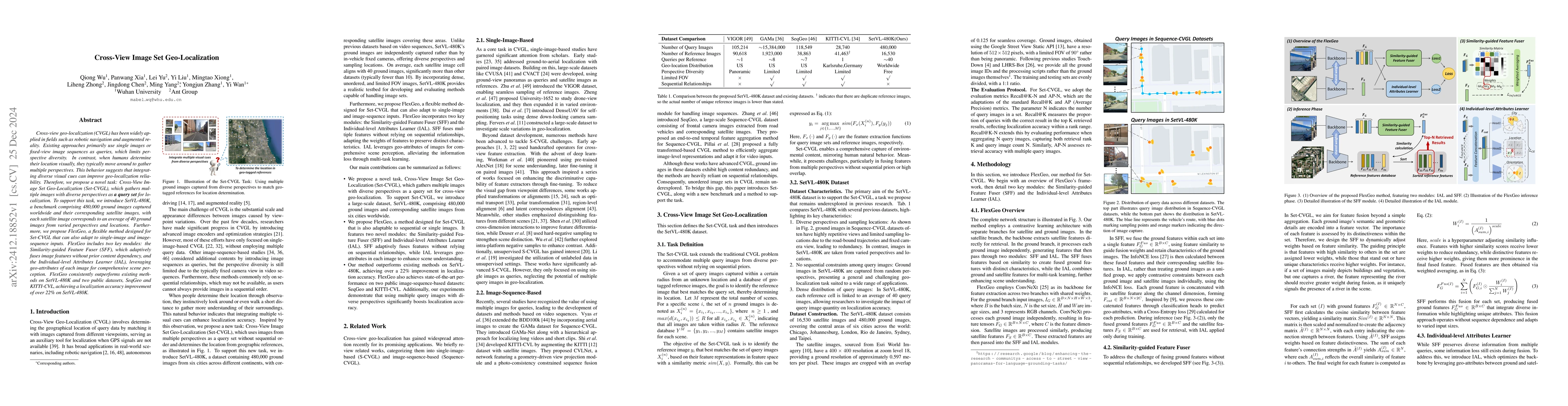
Cross-view geo-localization (CVGL) has been widely applied in fields such as robotic navigation and augmented reality. Existing approaches primarily use single images or fixed-view image sequences as ...

Thumbnail for Cross-View Geo-Localization with Street-View and VHR Satellite Imagery
  in Decentrality Settings
arXiv
Cross-View Geo-Localization with Street-View and VHR Satellite Imagery in Decentrality Settings

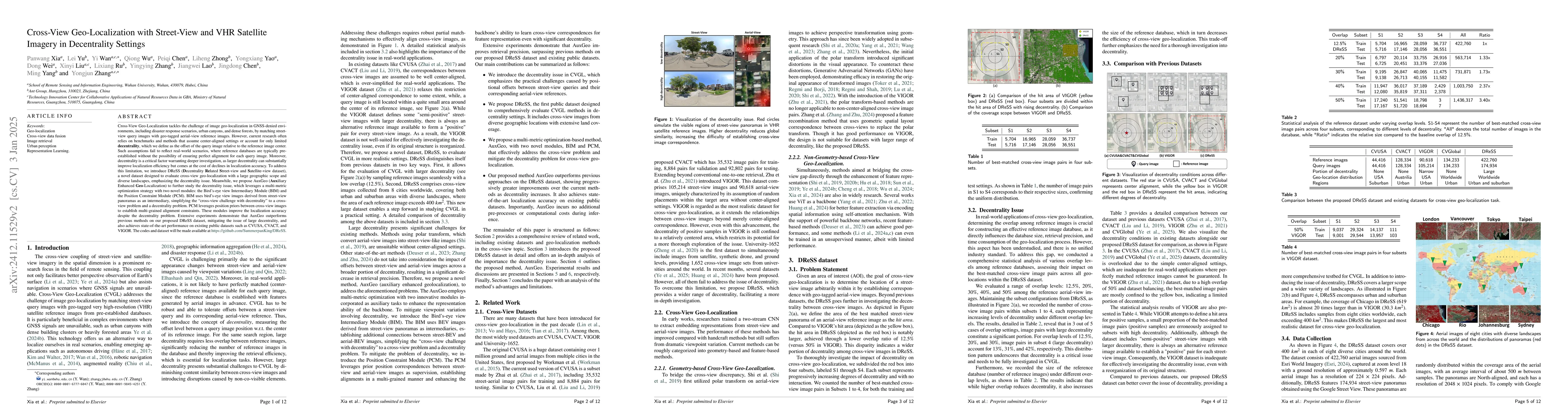
Cross-View Geo-Localization tackles the problem of image geo-localization in GNSS-denied environments by matching street-view query images with geo-tagged aerial-view reference images. However, existi...

Thumbnail for CasP: Improving Semi-Dense Feature Matching Pipeline Leveraging Cascaded
  Correspondence Priors for Guidance
arXiv
CasP: Improving Semi-Dense Feature Matching Pipeline Leveraging Cascaded Correspondence Priors for Guidance

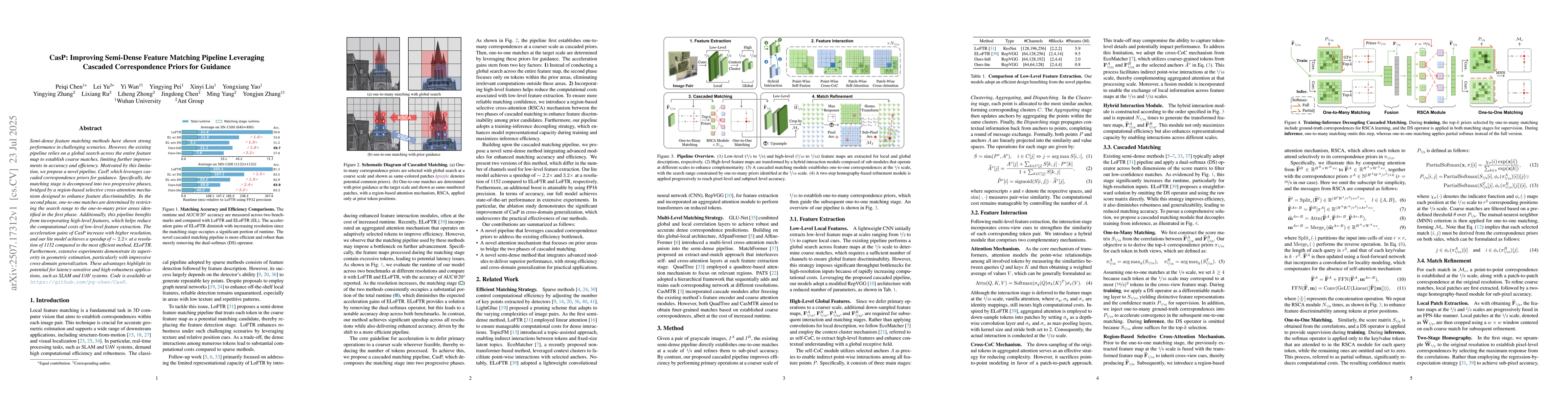
Semi-dense feature matching methods have shown strong performance in challenging scenarios. However, the existing pipeline relies on a global search across the entire feature map to establish coarse m...

Thumbnail for Adding a Storage Pool improves 3-PG Tree-ring Simulations
arXiv
Adding a Storage Pool improves 3-PG Tree-ring Simulations

Tree rings provide long-term records of tree growth and climate changes, which makes them ideal benchmarks for forest modeling. Tree-ring information has greatly improved the reliability of 3-PG, whic...

This website uses cookies to ensure you get the best experience. Learn more