Linus Scheibenreif

11 papers on arXiv

Academic Profile

Name: L. Scheibenreif
Total Papers: 18

Statistics

arXiv Papers 11
Total Publications 18

Papers on arXiv

Thumbnail for Ben-ge: Extending BigEarthNet with Geographical and Environmental Data

Ben-ge: Extending BigEarthNet with Geographical and Environmental Data

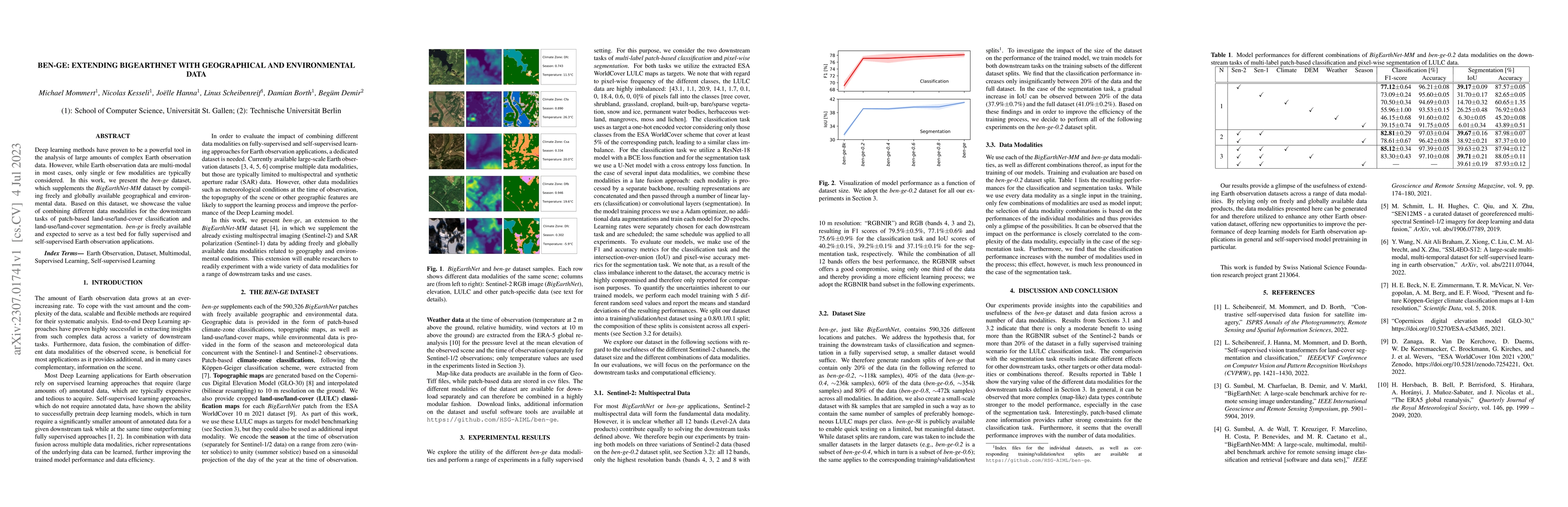
Deep learning methods have proven to be a powerful tool in the analysis of large amounts of complex Earth observation data. However, while Earth observation data are multi-modal in most cases, only ...

Thumbnail for Invariant Risk Minimisation for Cross-Organism Inference: Substituting
  Mouse Data for Human Data in Human Risk Factor Discovery

Invariant Risk Minimisation for Cross-Organism Inference: Substituting Mouse Data for Human Data in Human Risk Factor Discovery

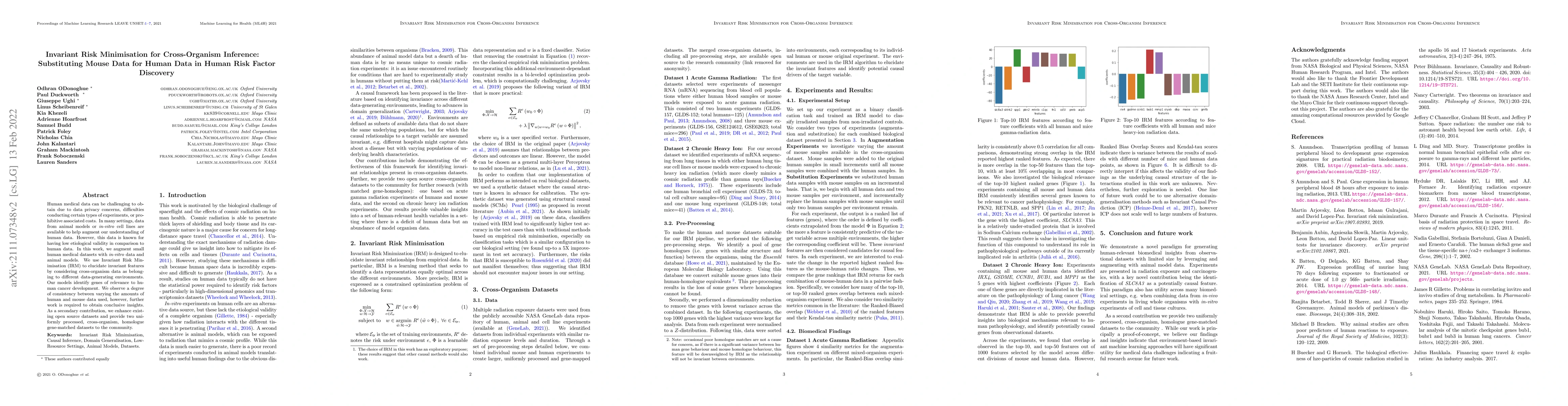
Human medical data can be challenging to obtain due to data privacy concerns, difficulties conducting certain types of experiments, or prohibitive associated costs. In many settings, data from anima...

Thumbnail for Estimation of Air Pollution with Remote Sensing Data: Revealing
  Greenhouse Gas Emissions from Space

Estimation of Air Pollution with Remote Sensing Data: Revealing Greenhouse Gas Emissions from Space

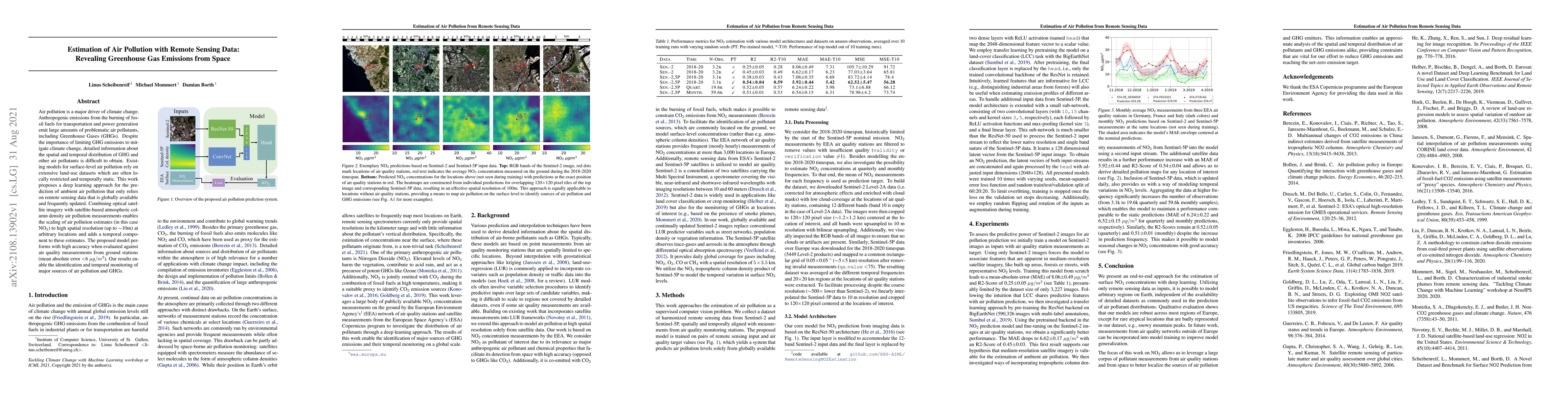
Air pollution is a major driver of climate change. Anthropogenic emissions from the burning of fossil fuels for transportation and power generation emit large amounts of problematic air pollutants, ...

Thumbnail for Power Plant Classification from Remote Imaging with Deep Learning

Power Plant Classification from Remote Imaging with Deep Learning

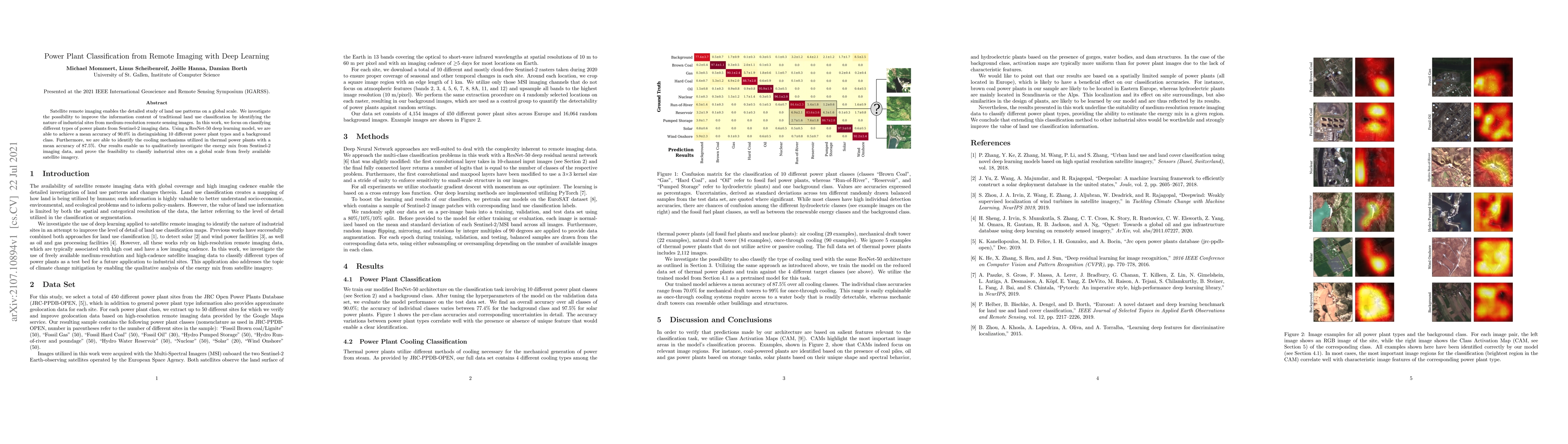
Satellite remote imaging enables the detailed study of land use patterns on a global scale. We investigate the possibility to improve the information content of traditional land use classification b...

Thumbnail for Characterization of Industrial Smoke Plumes from Remote Sensing Data

Characterization of Industrial Smoke Plumes from Remote Sensing Data

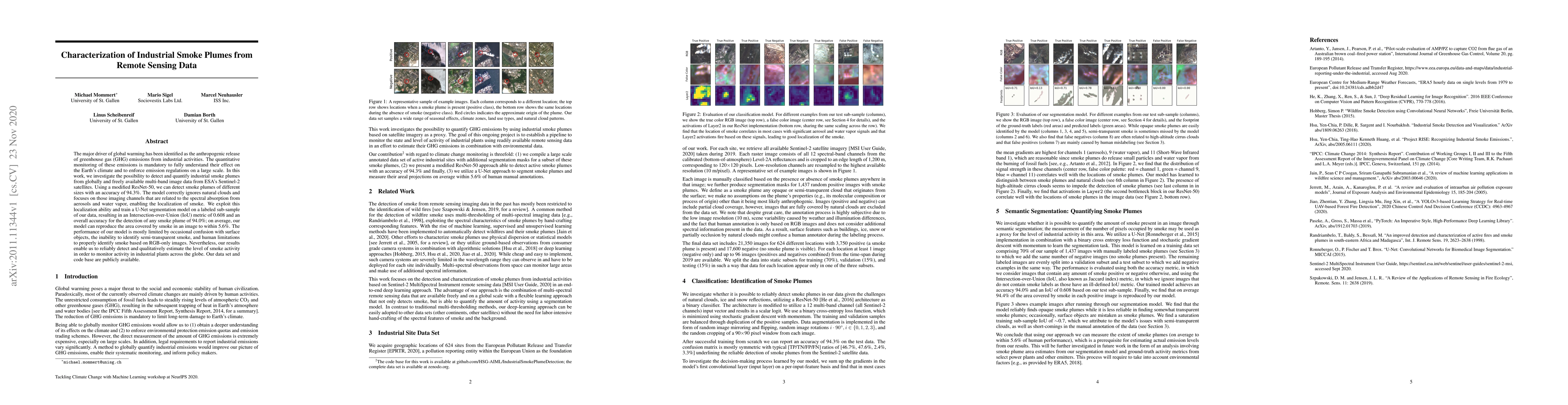
The major driver of global warming has been identified as the anthropogenic release of greenhouse gas (GHG) emissions from industrial activities. The quantitative monitoring of these emissions is ma...

Thumbnail for Fine-tune Smarter, Not Harder: Parameter-Efficient Fine-Tuning for
  Geospatial Foundation Models

Fine-tune Smarter, Not Harder: Parameter-Efficient Fine-Tuning for Geospatial Foundation Models

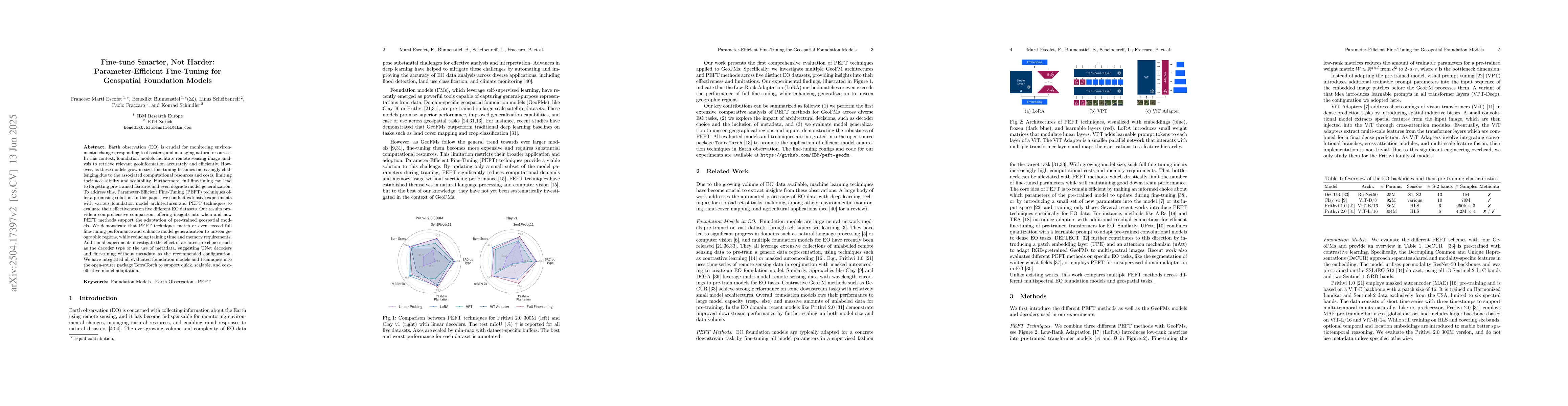
Earth observation (EO) is crucial for monitoring environmental changes, responding to disasters, and managing natural resources. In this context, foundation models facilitate remote sensing image anal...

Thumbnail for Dense Air Pollution Estimation from Sparse in-situ Measurements and
  Satellite Data

Dense Air Pollution Estimation from Sparse in-situ Measurements and Satellite Data

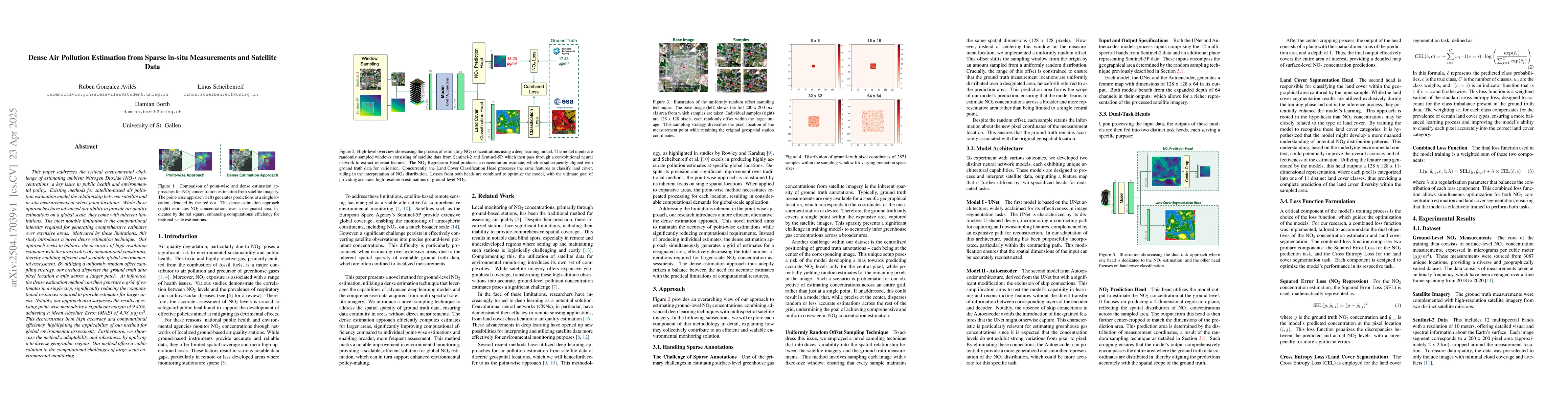
This paper addresses the critical environmental challenge of estimating ambient Nitrogen Dioxide (NO$_2$) concentrations, a key issue in public health and environmental policy. Existing methods for sa...

Thumbnail for Hyperspectral Vision Transformers for Greenhouse Gas Estimations from
  Space

Hyperspectral Vision Transformers for Greenhouse Gas Estimations from Space

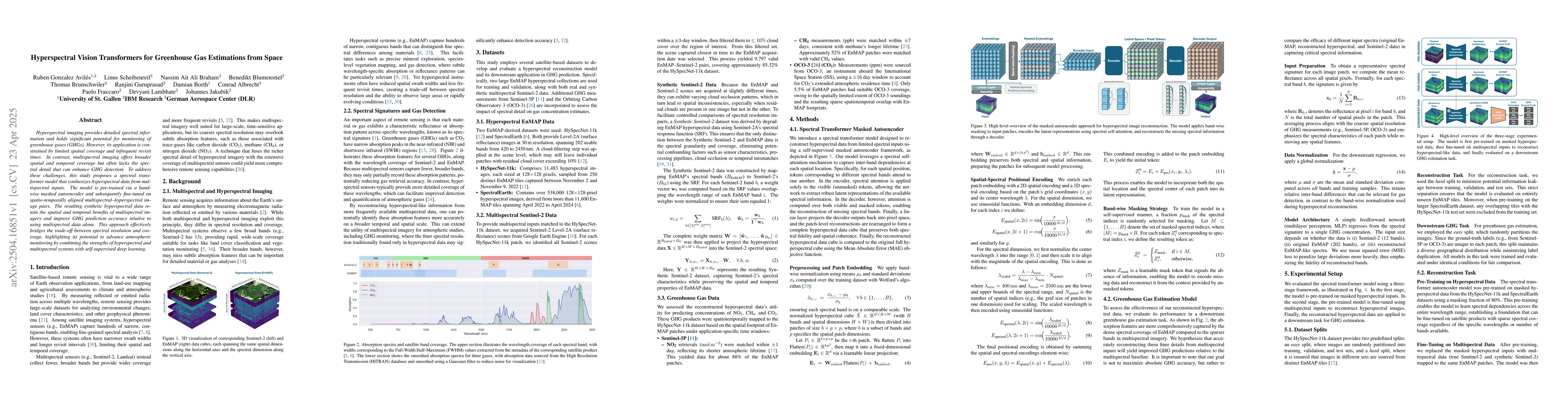
Hyperspectral imaging provides detailed spectral information and holds significant potential for monitoring of greenhouse gases (GHGs). However, its application is constrained by limited spatial cover...

Thumbnail for MAPEX: Modality-Aware Pruning of Experts for Remote Sensing Foundation
  Models

MAPEX: Modality-Aware Pruning of Experts for Remote Sensing Foundation Models

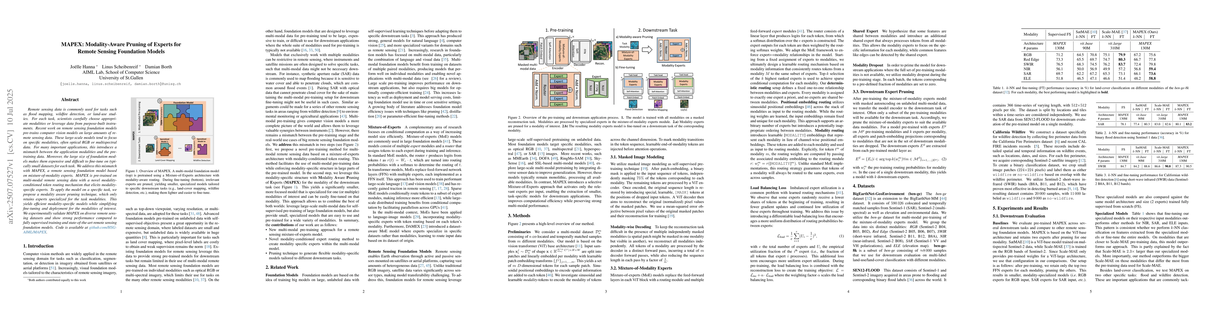
Remote sensing data is commonly used for tasks such as flood mapping, wildfire detection, or land-use studies. For each task, scientists carefully choose appropriate modalities or leverage data from p...

Thumbnail for The Potential of Copernicus Satellites for Disaster Response: Retrieving Building Damage from Sentinel-1 and Sentinel-2

The Potential of Copernicus Satellites for Disaster Response: Retrieving Building Damage from Sentinel-1 and Sentinel-2

Natural disasters demand rapid damage assessment to guide humanitarian response. Here, we investigate whether medium-resolution Earth observation images from the Copernicus program can support buildin...

Thumbnail for Reconstructing Multi-Decadal Forest Disturbances: A Spatio-Temporal Transformer Approach

Reconstructing Multi-Decadal Forest Disturbances: A Spatio-Temporal Transformer Approach

Accurate monitoring of forest disturbances is essential for understanding carbon dynamics and land management, yet traditional approaches typically rely on pixel-wise analysis of satellite time-series...

This website uses cookies to ensure you get the best experience. Learn more