ArxivLens
M
Researcher

Matěj Boxan

10 papers on arXiv

10 arXiv Papers
2 Total Publications
Profile

Academic Profile

Name Matej Boxan
Total Papers 2
Scholar Profile View on Semantic Scholar
Metrics

Statistics

10 arXiv Papers
2 Total Publications
Publications

Papers on arXiv

Thumbnail for Field Report on a Wearable and Versatile Solution for Field Acquisition
  and Exploration
arXiv
Field Report on a Wearable and Versatile Solution for Field Acquisition and Exploration

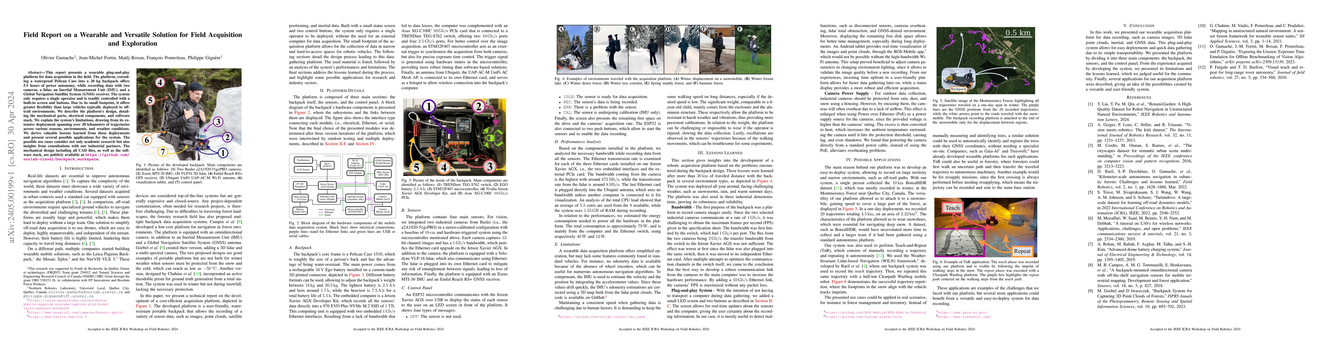
This report presents a wearable plug-and-play platform for data acquisition in the field. The platform, extending a waterproof Pelican Case into a 20 kg backpack offers 5.5 hours of power autonomy, ...

Thumbnail for 3D Mapping of Glacier Moulins: Challenges and lessons learned
arXiv
3D Mapping of Glacier Moulins: Challenges and lessons learned

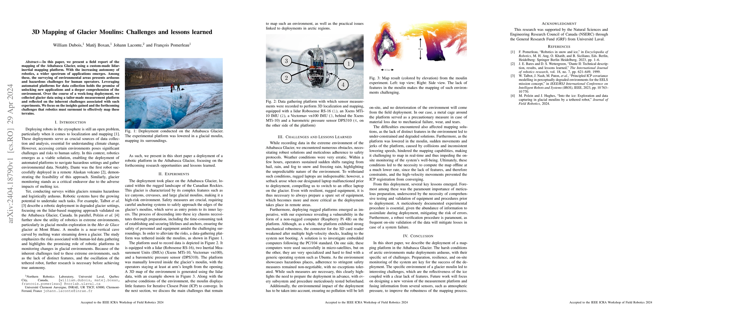
In this paper, we present a field report of the mapping of the Athabasca Glacier, using a custom-made lidar-inertial mapping platform. With the increasing autonomy of robotics, a wider spectrum of a...

Thumbnail for FoMo: A Proposal for a Multi-Season Dataset for Robot Navigation in
  For\^et Montmorency
arXiv
FoMo: A Proposal for a Multi-Season Dataset for Robot Navigation in For\^et Montmorency

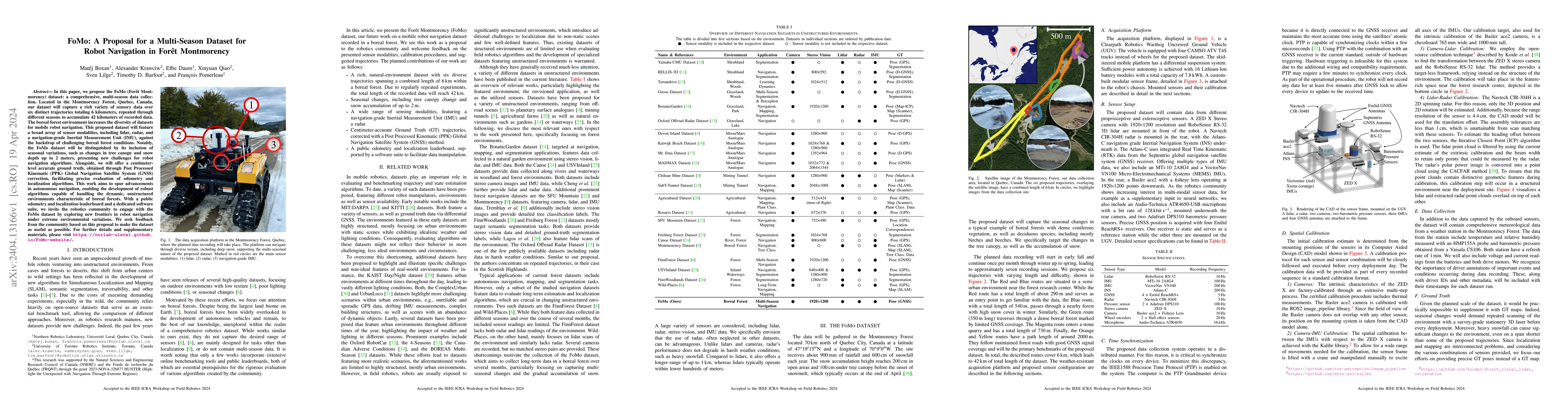
In this paper, we propose the FoMo (For\^et Montmorency) dataset: a comprehensive, multi-season data collection. Located in the Montmorency Forest, Quebec, Canada, our dataset will capture a rich va...

Thumbnail for Saturation-Aware Angular Velocity Estimation: Extending the Robustness
  of SLAM to Aggressive Motions
arXiv
Saturation-Aware Angular Velocity Estimation: Extending the Robustness of SLAM to Aggressive Motions

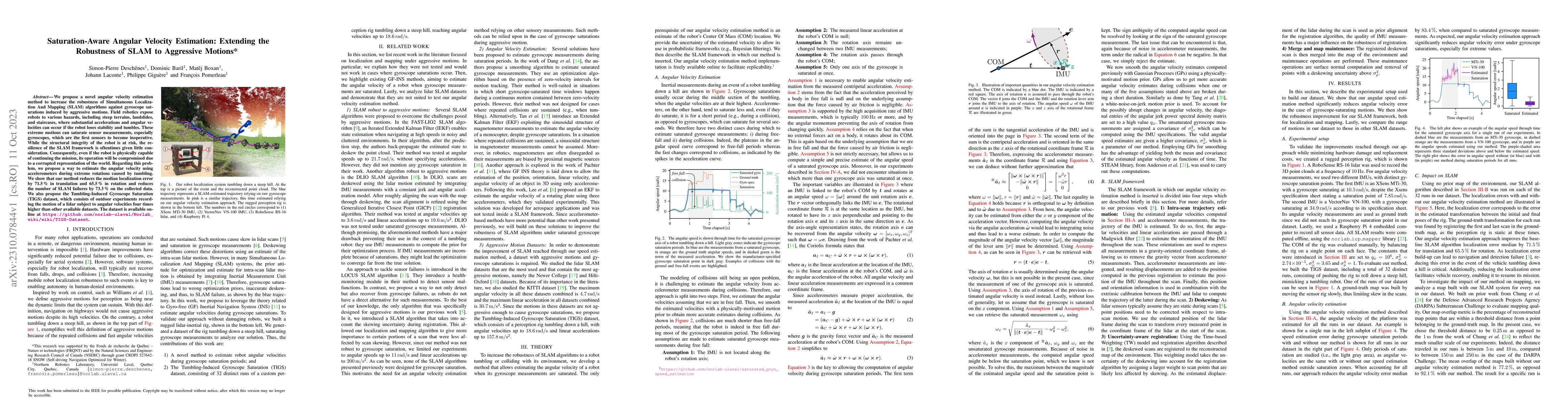
We propose a novel angular velocity estimation method to increase the robustness of Simultaneous Localization And Mapping (SLAM) algorithms against gyroscope saturations induced by aggressive motion...

Thumbnail for Exposing the Unseen: Exposure Time Emulation for Offline Benchmarking of
  Vision Algorithms
arXiv
Exposing the Unseen: Exposure Time Emulation for Offline Benchmarking of Vision Algorithms

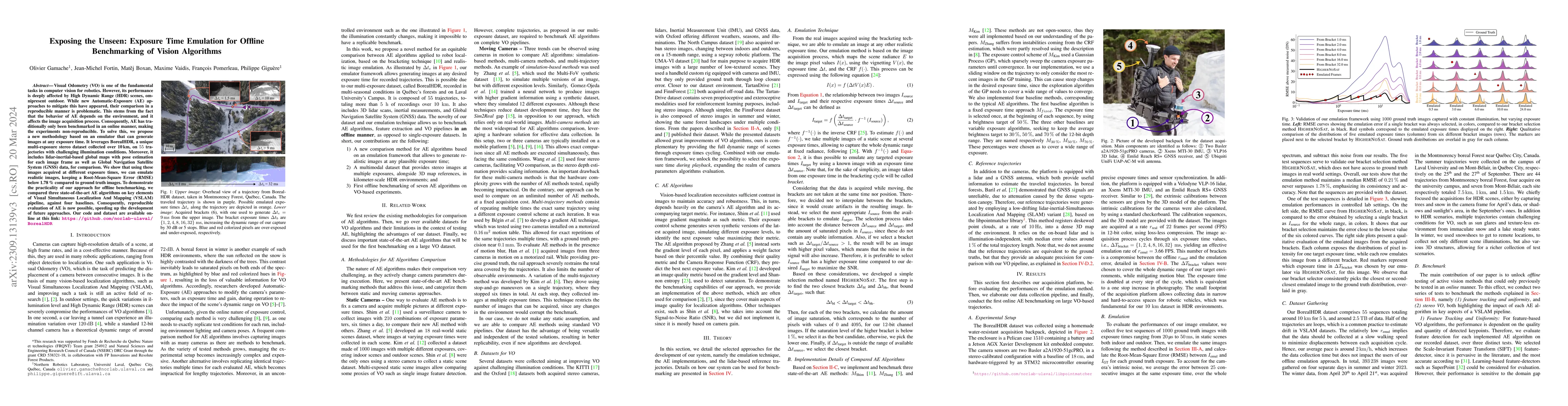
Visual Odometry (VO) is one of the fundamental tasks in computer vision for robotics. However, its performance is deeply affected by High Dynamic Range (HDR) scenes, omnipresent outdoor. While new A...

Thumbnail for Toward Teach and Repeat Across Seasonal Deep Snow Accumulation
arXiv
Toward Teach and Repeat Across Seasonal Deep Snow Accumulation

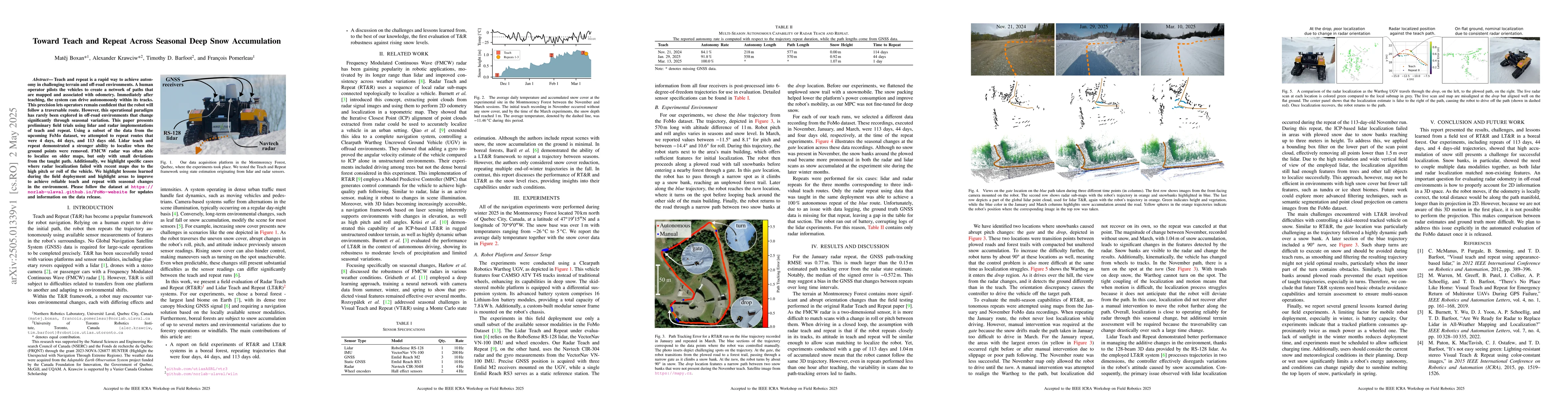
Teach and repeat is a rapid way to achieve autonomy in challenging terrain and off-road environments. A human operator pilots the vehicles to create a network of paths that are mapped and associated w...

Thumbnail for Reproducible Evaluation of Camera Auto-Exposure Methods in the Field:
  Platform, Benchmark and Lessons Learned
arXiv
Reproducible Evaluation of Camera Auto-Exposure Methods in the Field: Platform, Benchmark and Lessons Learned

Standard datasets often present limitations, particularly due to the fixed nature of input data sensors, which makes it difficult to compare methods that actively adjust sensor parameters to suit envi...

Thumbnail for FoMo: A Multi-Season Dataset for Robot Navigation in Forêt Montmorency
arXiv
FoMo: A Multi-Season Dataset for Robot Navigation in Forêt Montmorency

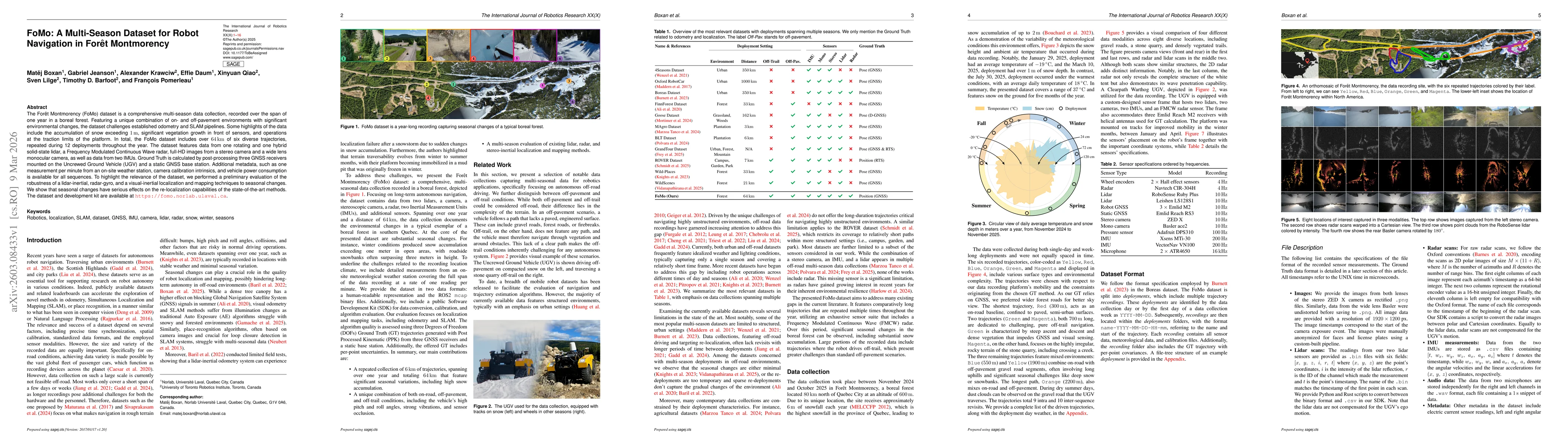
The Forêt Montmorency (FoMo) dataset is a comprehensive multi-season data collection, recorded over the span of one year in a boreal forest. Featuring a unique combination of on- and off-pavement envi...

Thumbnail for Radar Odometry Subject to High Tilt Dynamics of Subarctic Environments
arXiv
Radar Odometry Subject to High Tilt Dynamics of Subarctic Environments

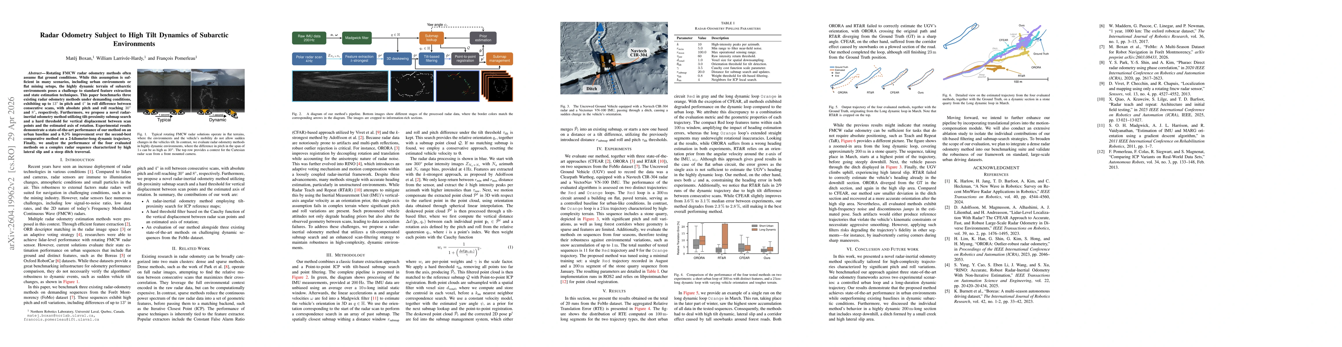
Rotating FMCW radar odometry methods often assume flat ground conditions. While this assumption is sufficient in many scenarios, including urban environments or flat mining setups, the highly dynamic ...

Thumbnail for Leveraging Image Generators to Address Training Data Scarcity: The Gen4Regen Dataset for Forest Regeneration Mapping
arXiv
Leveraging Image Generators to Address Training Data Scarcity: The Gen4Regen Dataset for Forest Regeneration Mapping

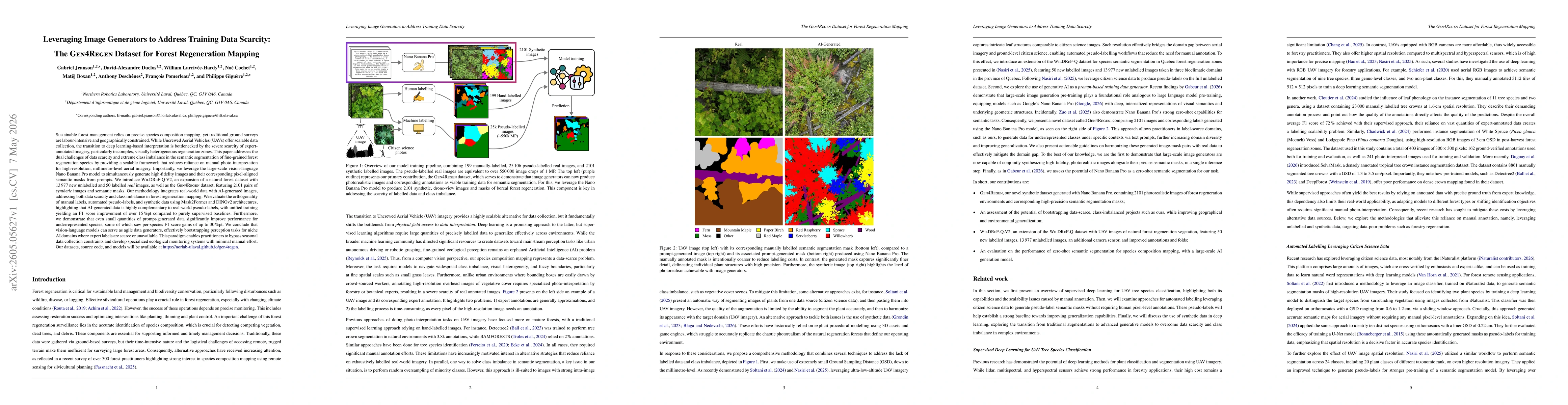
Sustainable forest management relies on precise species composition mapping, yet traditional ground surveys are labour-intensive and geographically constrained. While Uncrewed Aerial Vehicles (UAVs) o...

This website uses cookies to ensure you get the best experience. Learn more