ArxivLens
M
Researcher

Mohamed Atia

7 papers on arXiv

7 arXiv Papers
71 Total Publications
Profile

Academic Profile

Name M. Atia
Total Papers 71
Scholar Profile View on Semantic Scholar
Metrics

Statistics

7 arXiv Papers
71 Total Publications
Publications

Papers on arXiv

Thumbnail for Realistic Channel and Delay Coefficient Generation for Dual Mobile
  Space-Ground Links - A Tutorial-
arXiv
Realistic Channel and Delay Coefficient Generation for Dual Mobile Space-Ground Links - A Tutorial-

Channel and delay coefficient are two essential parameters for the characterization of a multipath propagation environment. It is crucial to generate realistic channel and delay coefficient in order...

Thumbnail for Synthetic Waveform Generation for Satellite, HAPS, and 5G Base Station
  Positioning Reference Signal Using QuaDRiGa
arXiv
Synthetic Waveform Generation for Satellite, HAPS, and 5G Base Station Positioning Reference Signal Using QuaDRiGa

Waveform generation is essential for studying signal propagation and channel characteristics, particularly for objects that are conceptualized but still need to be operational. We introduce a compre...

Thumbnail for A Positioning System in an Urban Vertical Heterogeneous Network
  (VHetNet)
arXiv
A Positioning System in an Urban Vertical Heterogeneous Network (VHetNet)

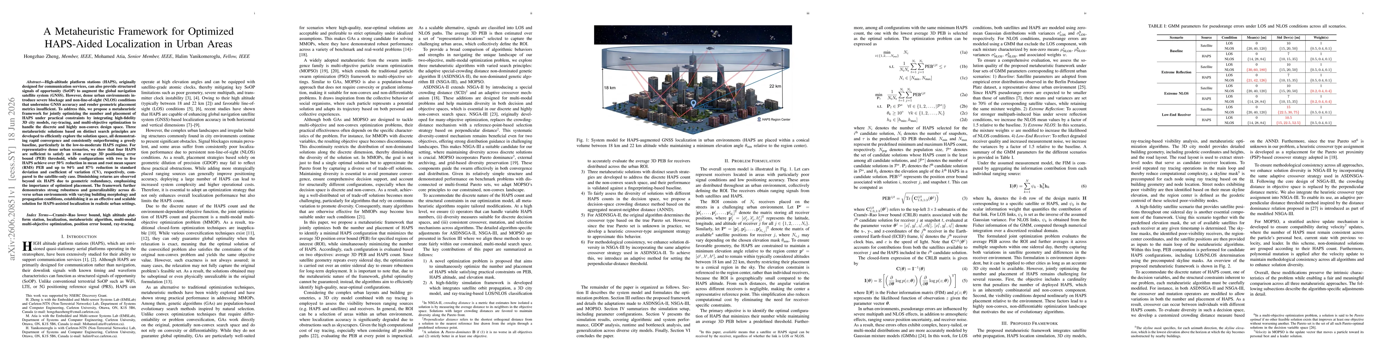
Global navigation satellite systems (GNSSs) are essential in providing localization and navigation services to most of the world due to their superior coverage. However, due to high pathloss and ine...

Thumbnail for High Altitude Platform Station (HAPS)-Aided GNSS for Urban Areas
arXiv
High Altitude Platform Station (HAPS)-Aided GNSS for Urban Areas

Today the global averaged civilian positioning accuracy is still at meter level for all existing Global Navigation Satellite Systems (GNSSs), and the civilian positioning performance is even worse i...

Thumbnail for Analysis of a HAPS-Aided GNSS in Urban Areas using a RAIM Algorithm
arXiv
Analysis of a HAPS-Aided GNSS in Urban Areas using a RAIM Algorithm

The global averaged civilian positioning accuracy is still at meter level for all existing Global Navigation Satellite Systems (GNSSs), and the performance is even worse in urban areas. At lower alt...

Thumbnail for Optimized Deployment of HAPS Systems for GNSS Localization Enhancement in Urban Environments
arXiv
Optimized Deployment of HAPS Systems for GNSS Localization Enhancement in Urban Environments

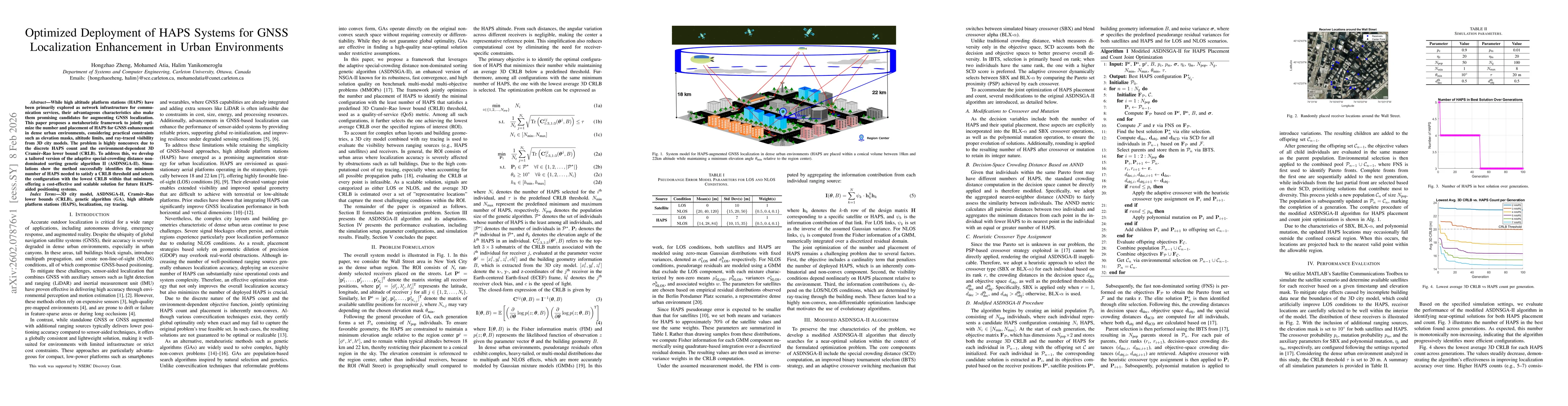
While high altitude platform stations (HAPS) have been primarily explored as network infrastructure for communication services, their advantageous characteristics also make them promising candidates f...

Thumbnail for A Metaheuristic Framework for Optimized HAPS-Aided Localization in Urban Areas
arXiv
A Metaheuristic Framework for Optimized HAPS-Aided Localization in Urban Areas

High-altitude platform stations (HAPS), originally designed for communication services, can also provide structured signals of opportunity (SoOP) to augment the global navigation satellite system (GNS...

This website uses cookies to ensure you get the best experience. Learn more