ArxivLens
P
Researcher

Philippe Rufin

6 papers on arXiv

6 arXiv Papers
39 Total Publications
Profile

Academic Profile

Name Philippe Rufin
Total Papers 39
Scholar Profile View on Semantic Scholar
Metrics

Statistics

6 arXiv Papers
39 Total Publications
Publications

Papers on arXiv

Thumbnail for Responsible AI for Earth Observation
arXiv
Responsible AI for Earth Observation

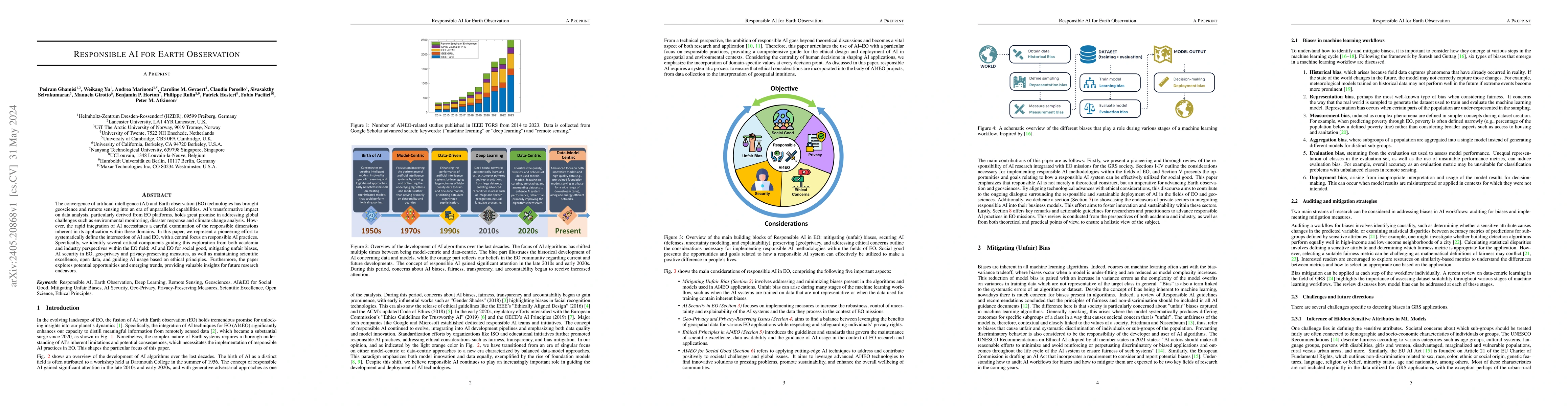
The convergence of artificial intelligence (AI) and Earth observation (EO) technologies has brought geoscience and remote sensing into an era of unparalleled capabilities. AI's transformative impact...

Thumbnail for Explaining the emergence of land-use frontiers
arXiv
Explaining the emergence of land-use frontiers

Land use expansion is linked to major sustainability concerns including climate change, food security and biodiversity loss. This expansion is largely concentrated in so-called frontiers, defined he...

Thumbnail for Taking it further: leveraging pseudo labels for field delineation across
  label-scarce smallholder regions
arXiv
Taking it further: leveraging pseudo labels for field delineation across label-scarce smallholder regions

Transfer learning allows for resource-efficient geographic transfer of pre-trained field delineation models. However, the scarcity of labeled data for complex and dynamic smallholder landscapes, par...

Thumbnail for National level satellite-based crop field inventories in smallholder
  landscapes
arXiv
National level satellite-based crop field inventories in smallholder landscapes

The design of science-based policies to improve the sustainability of smallholder agriculture is challenged by a limited understanding of fundamental system properties, such as the spatial distributio...

Thumbnail for Leveraging AI multimodal geospatial foundation models for improved near-real-time flood mapping at a global scale
arXiv
Leveraging AI multimodal geospatial foundation models for improved near-real-time flood mapping at a global scale

Floods are among the most damaging weather-related hazards, and in 2024, the warmest year on record, extreme flood events affected communities across five continents. Earth observation (EO) satellites...

Thumbnail for The role of spatial context and multitask learning in the detection of organic and conventional farming systems based on Sentinel-2 time series
arXiv
The role of spatial context and multitask learning in the detection of organic and conventional farming systems based on Sentinel-2 time series

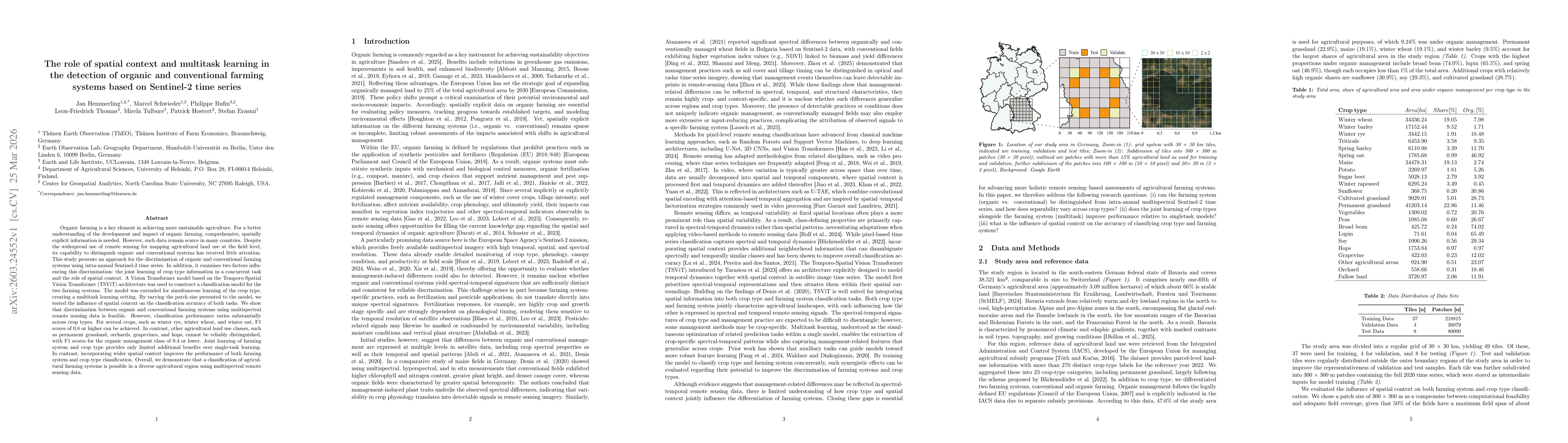
Organic farming is a key element in achieving more sustainable agriculture. For a better understanding of the development and impact of organic farming, comprehensive, spatially explicit information i...

This website uses cookies to ensure you get the best experience. Learn more