Raphael Canals

11 papers on arXiv

Academic Profile

Name: R. Canals
Total Papers: 4

Statistics

arXiv Papers 11
Total Publications 4

Papers on arXiv

Thumbnail for Generative models-based data labeling for deep networks regression:
  application to seed maturity estimation from UAV multispectral images

Generative models-based data labeling for deep networks regression: application to seed maturity estimation from UAV multispectral images

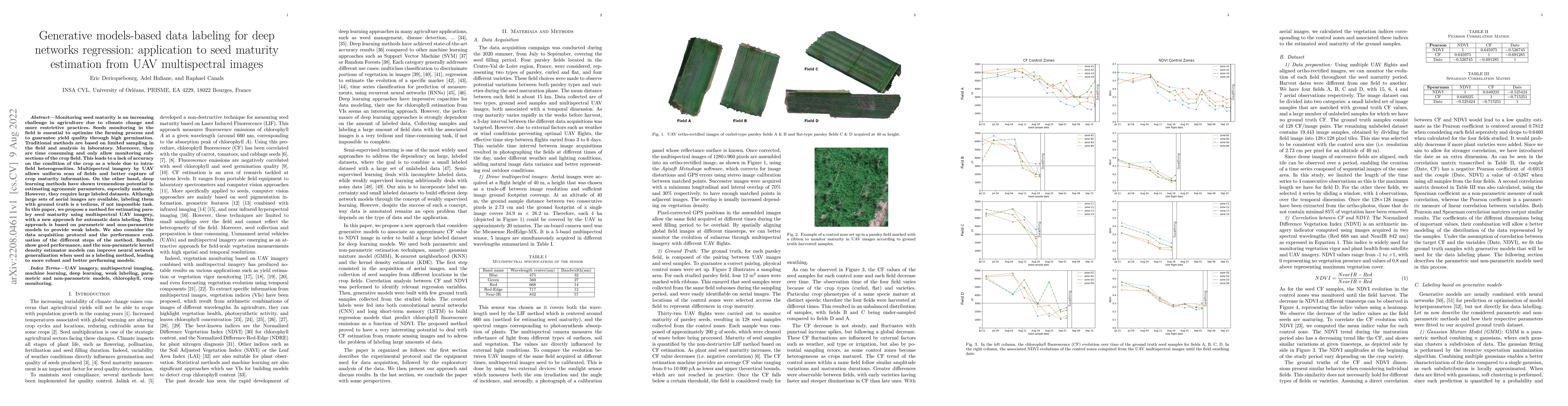
Monitoring seed maturity is an increasing challenge in agriculture due to climate change and more restrictive practices. Seeds monitoring in the field is essential to optimize the farming process an...

Thumbnail for Vision Transformers For Weeds and Crops Classification Of High
  Resolution UAV Images

Vision Transformers For Weeds and Crops Classification Of High Resolution UAV Images

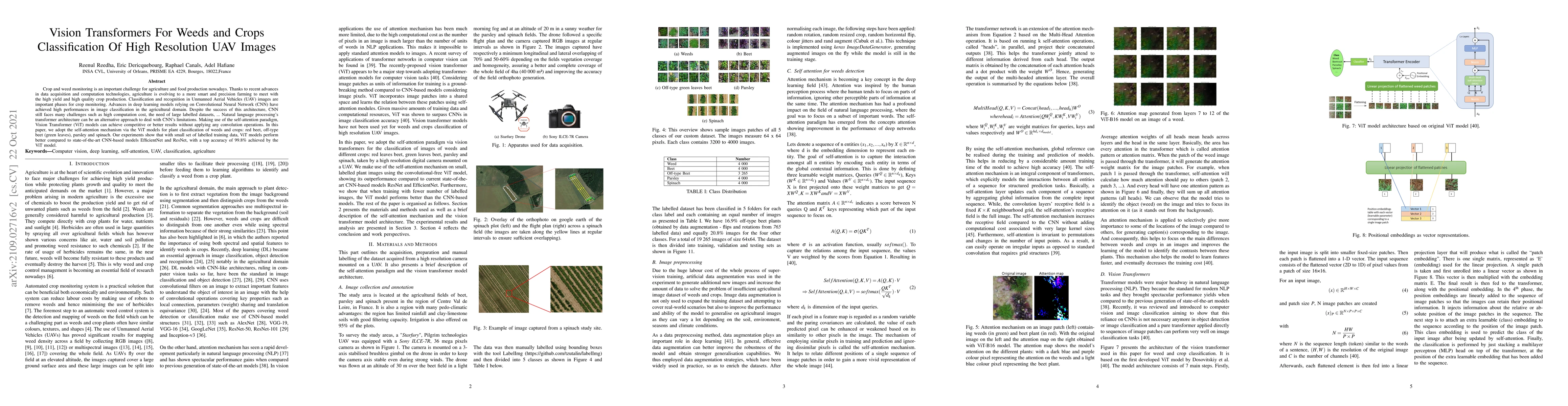
Crop and weed monitoring is an important challenge for agriculture and food production nowadays. Thanks to recent advances in data acquisition and computation technologies, agriculture is evolving t...

Thumbnail for VddNet: Vine Disease Detection Network Based on Multispectral Images and
  Depth Map

VddNet: Vine Disease Detection Network Based on Multispectral Images and Depth Map

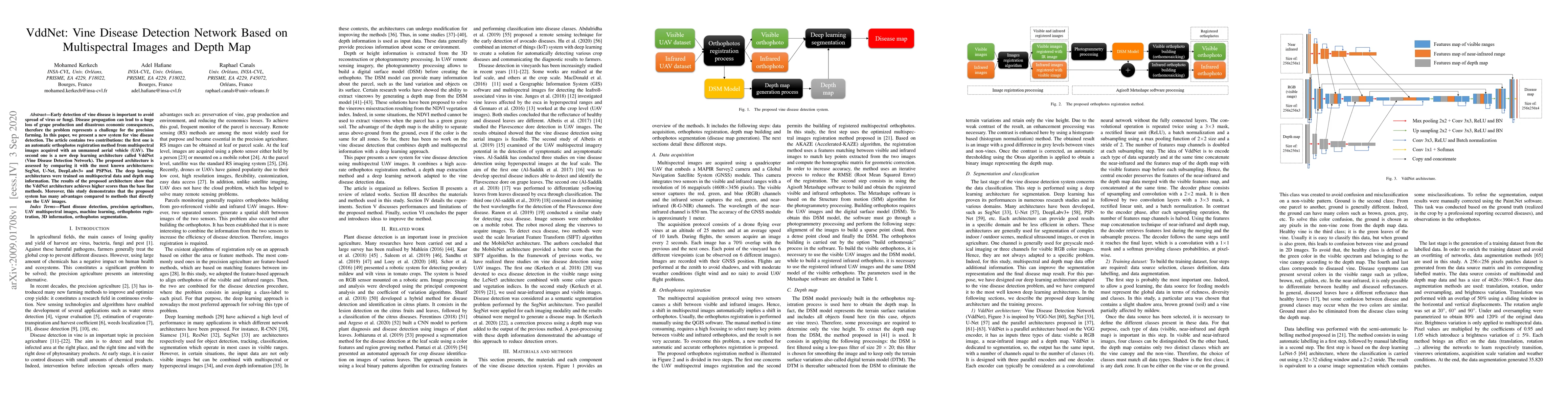
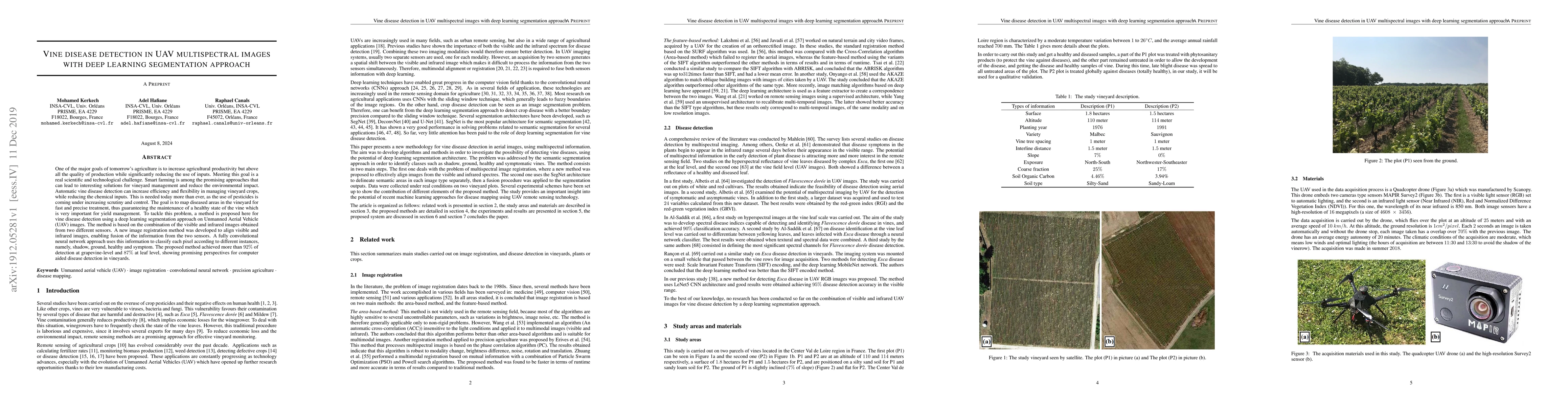
Early detection of vine disease is important to avoid spread of virus or fungi. Disease propagation can lead to a huge loss of grape production and disastrous economic consequences, therefore the pr...

Thumbnail for Vine disease detection in UAV multispectral images with deep learning
  segmentation approach

Vine disease detection in UAV multispectral images with deep learning segmentation approach

One of the major goals of tomorrow's agriculture is to increase agricultural productivity but above all the quality of production while significantly reducing the use of inputs. Meeting this goal is...

Thumbnail for Deep Learning for Spatio-Temporal Fusion in Land Surface Temperature
  Estimation: A Comprehensive Survey, Experimental Analysis, and Future Trends

Deep Learning for Spatio-Temporal Fusion in Land Surface Temperature Estimation: A Comprehensive Survey, Experimental Analysis, and Future Trends

The rapid advancements in satellite remote sensing have enhanced the capability to monitor and analyze the Earth's surface. Among the many variables captured through satellite sensors, Land Surface Te...

Thumbnail for Loss-Guided Model Sharing and Local Learning Correction in Decentralized
  Federated Learning for Crop Disease Classification

Loss-Guided Model Sharing and Local Learning Correction in Decentralized Federated Learning for Crop Disease Classification

Crop disease detection and classification is a critical challenge in agriculture, with major implications for productivity, food security, and environmental sustainability. While deep learning models ...

Thumbnail for FuseTen: A Generative Model for Daily 10 m Land Surface Temperature
  Estimation from Spatio-Temporal Satellite Observations

FuseTen: A Generative Model for Daily 10 m Land Surface Temperature Estimation from Spatio-Temporal Satellite Observations

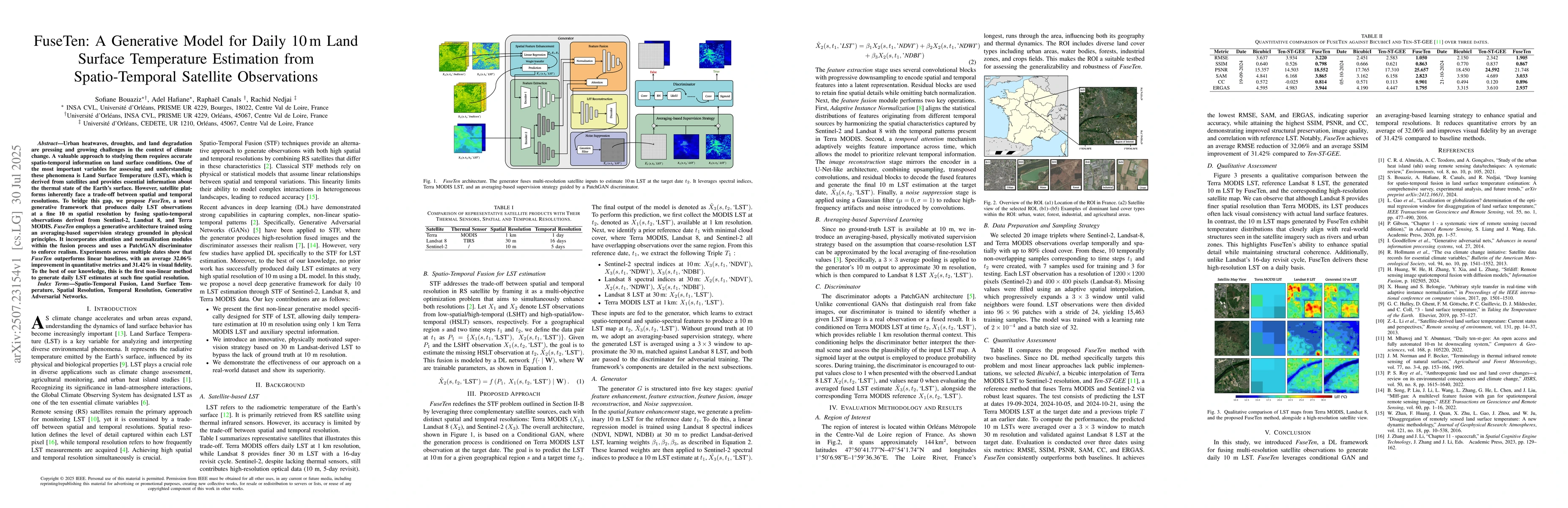
Urban heatwaves, droughts, and land degradation are pressing and growing challenges in the context of climate change. A valuable approach to studying them requires accurate spatio-temporal information...

Thumbnail for WGAST: Weakly-Supervised Generative Network for Daily 10 m Land Surface
  Temperature Estimation via Spatio-Temporal Fusion

WGAST: Weakly-Supervised Generative Network for Daily 10 m Land Surface Temperature Estimation via Spatio-Temporal Fusion

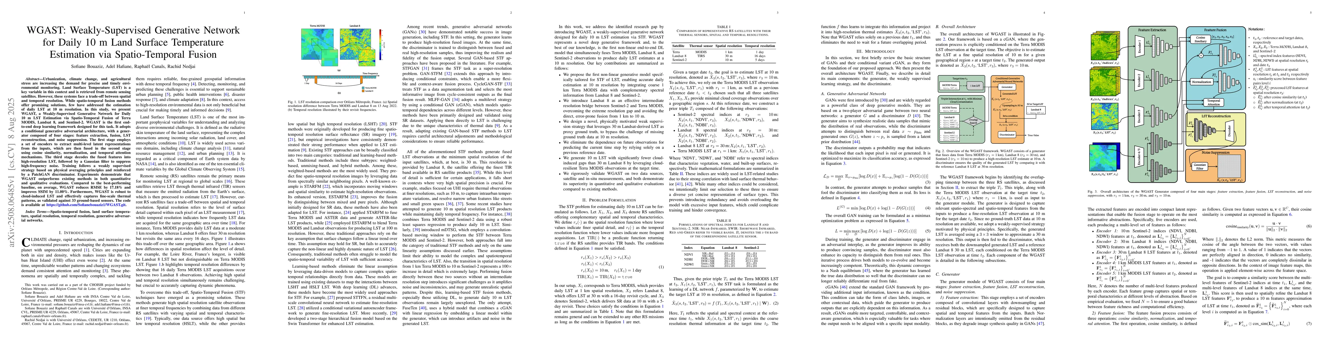
Urbanization, climate change, and agricultural stress are increasing the demand for precise and timely environmental monitoring. Land Surface Temperature (LST) is a key variable in this context and is...

Thumbnail for Deep semi-supervised approach based on consistency regularization and
  similarity learning for weeds classification

Deep semi-supervised approach based on consistency regularization and similarity learning for weeds classification

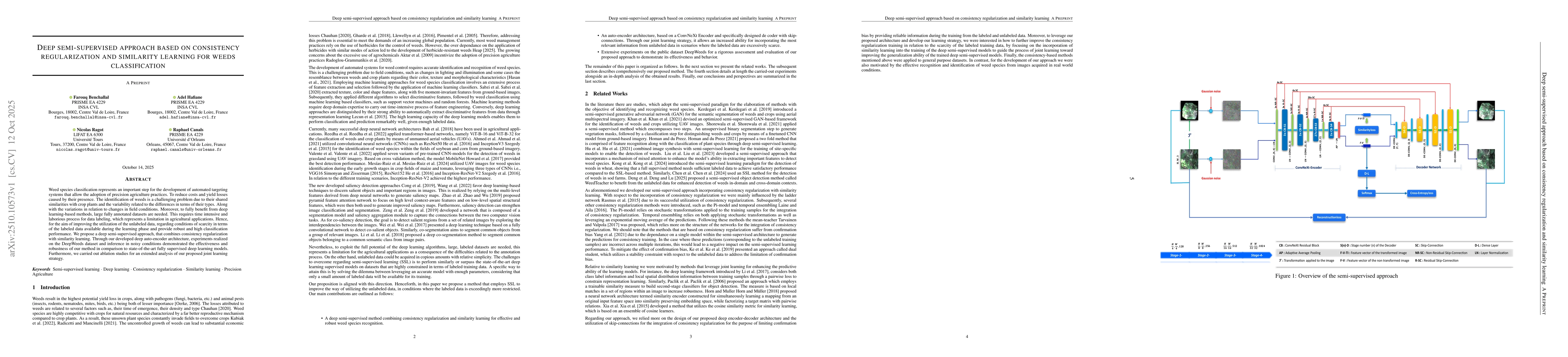
Weed species classification represents an important step for the development of automated targeting systems that allow the adoption of precision agriculture practices. To reduce costs and yield losses...

Thumbnail for SPyCer: Semi-Supervised Physics-Guided Contextual Attention for Near-Surface Air Temperature Estimation from Satellite Imagery

SPyCer: Semi-Supervised Physics-Guided Contextual Attention for Near-Surface Air Temperature Estimation from Satellite Imagery

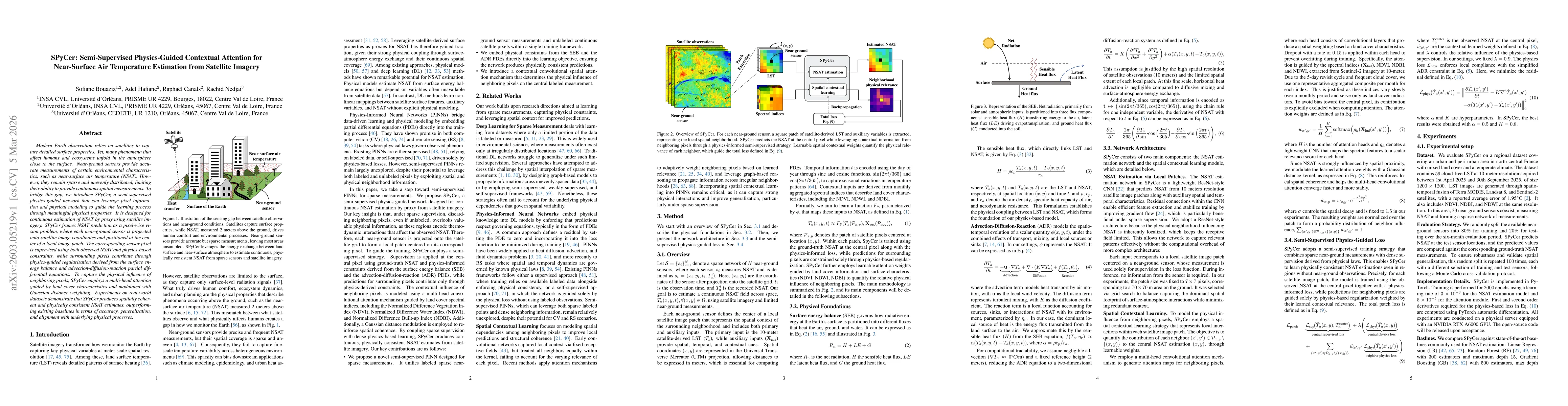
Modern Earth observation relies on satellites to capture detailed surface properties. Yet, many phenomena that affect humans and ecosystems unfold in the atmosphere close to the surface. Near-ground s...

Thumbnail for Uncertainty-Aware Test-Time Adaptation for Cross-Region Spatio-Temporal Fusion of Land Surface Temperature

Uncertainty-Aware Test-Time Adaptation for Cross-Region Spatio-Temporal Fusion of Land Surface Temperature

Deep learning models have shown great promise in diverse remote sensing applications. However, they often struggle to generalize across geographic regions unseen during training due to domain shifts. ...

This website uses cookies to ensure you get the best experience. Learn more