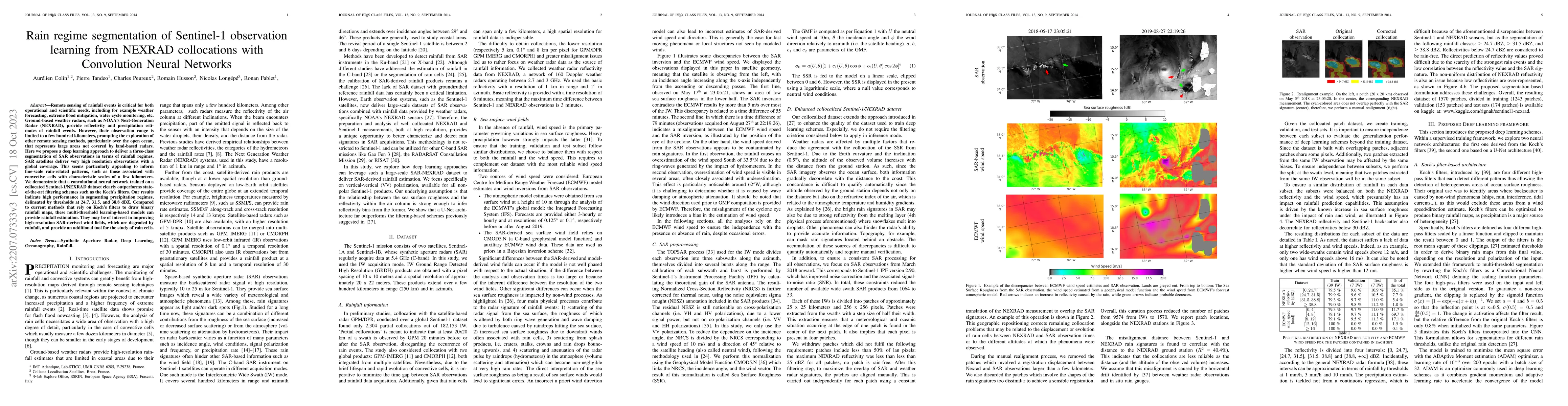
Academic Profile
Statistics
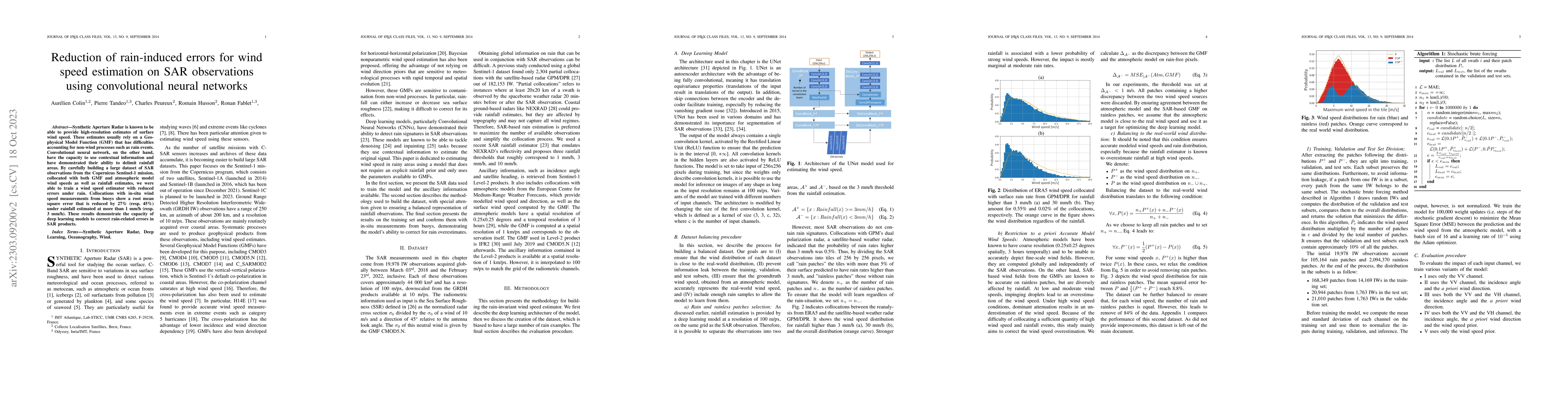
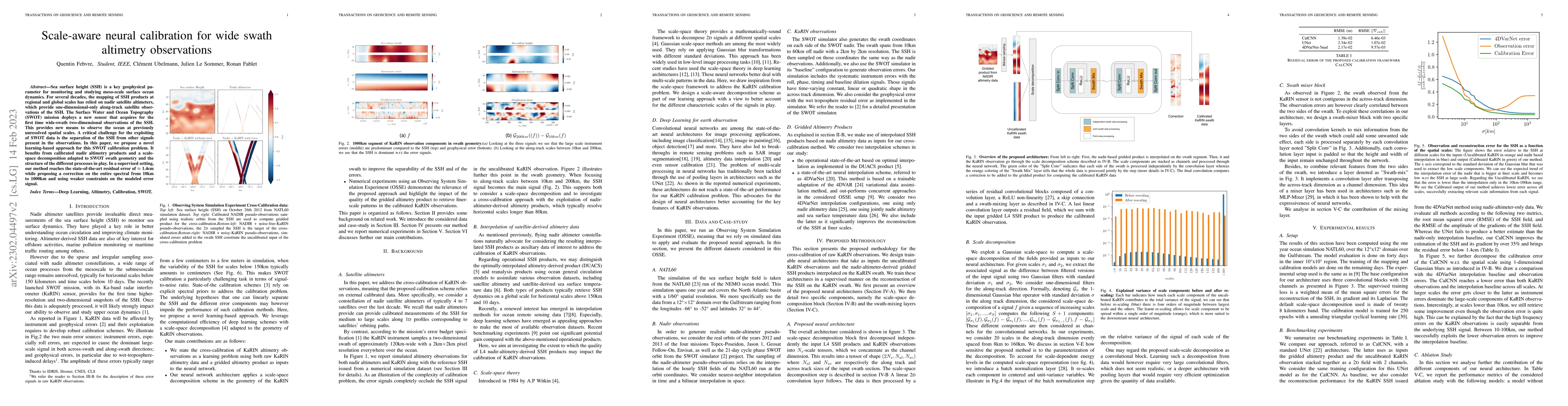
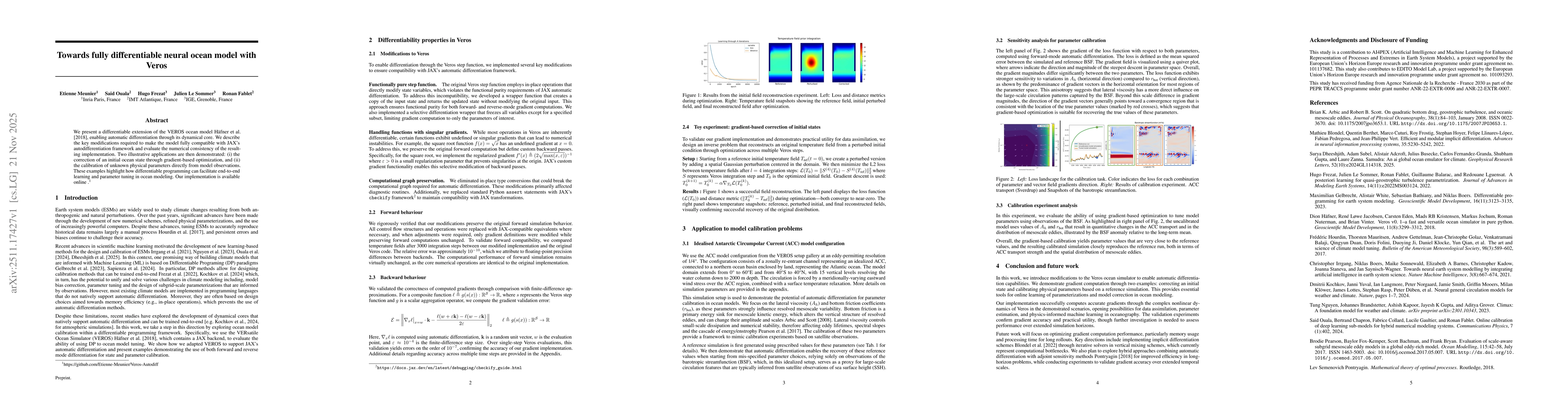
Similar Authors
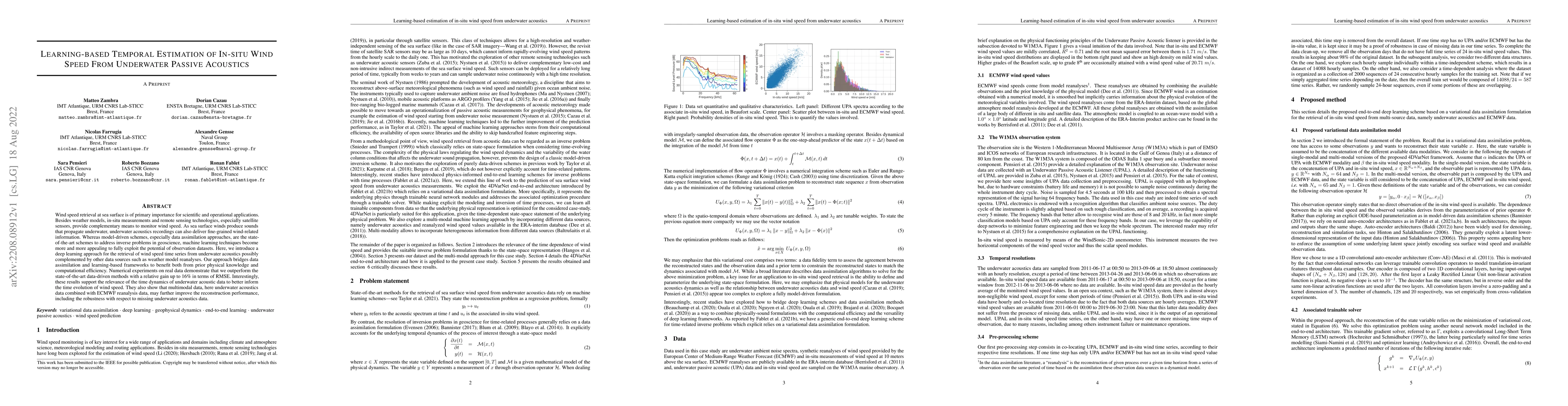
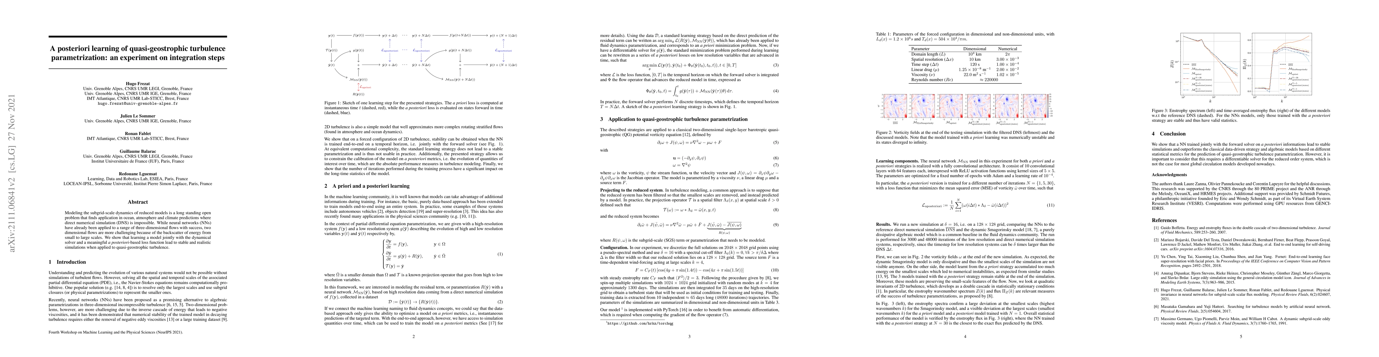
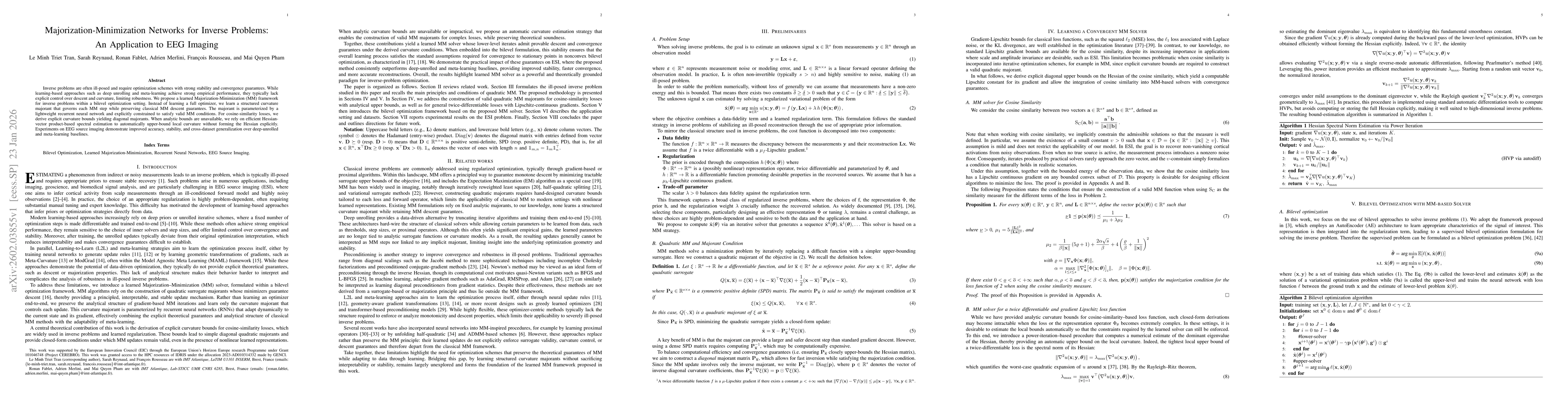
Papers on arXiv
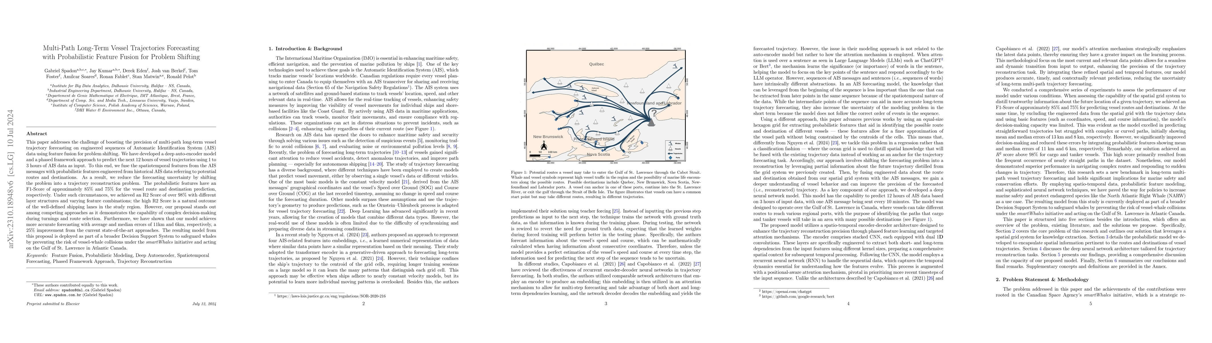
This paper addresses the challenge of boosting the precision of multi-path long-term vessel trajectory forecasting on engineered sequences of Automatic Identification System (AIS) data using feature f...

Data assimilation is a central problem in many geophysical applications, such as weather forecasting. It aims to estimate the state of a potentially large system, such as the atmosphere, from sparse...
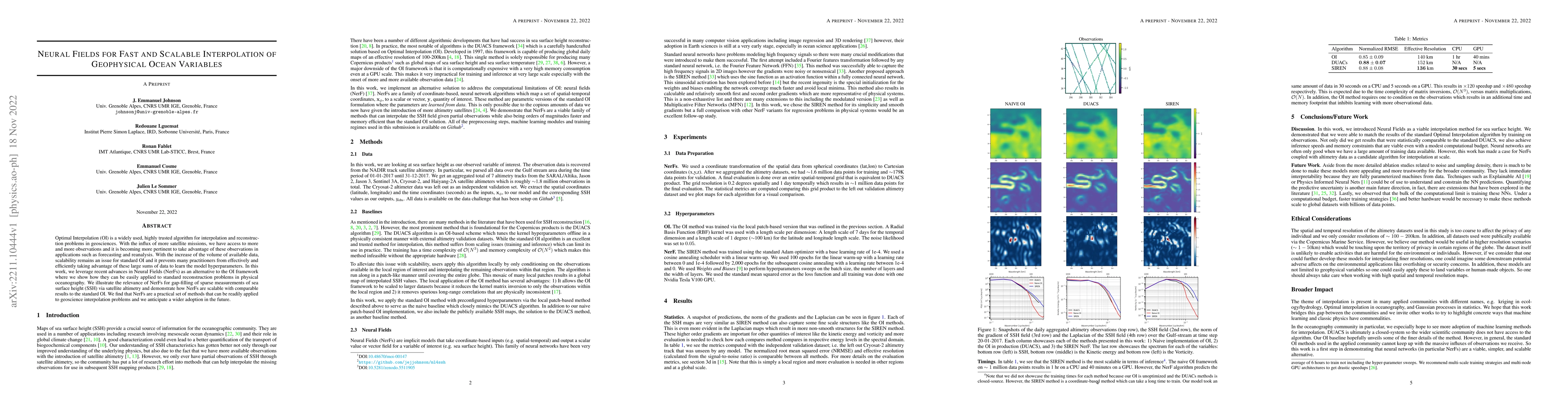
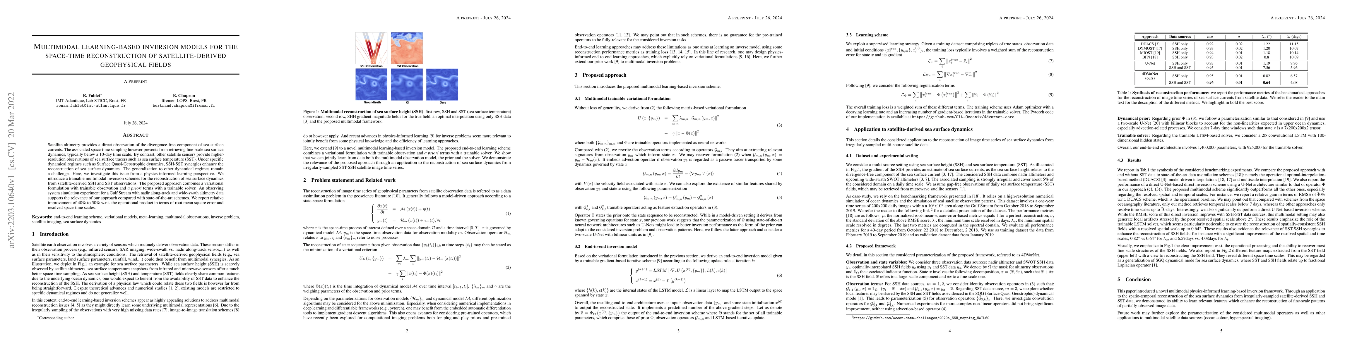
The spatio-temporal interpolation of large geophysical datasets has historically been adressed by Optimal Interpolation (OI) and more sophisticated model-based or data-driven DA techniques. In the l...
Wind speed at sea surface is a key quantity for a variety of scientific applications and human activities. Due to the non-linearity of the phenomenon, a complete description of such variable is made...
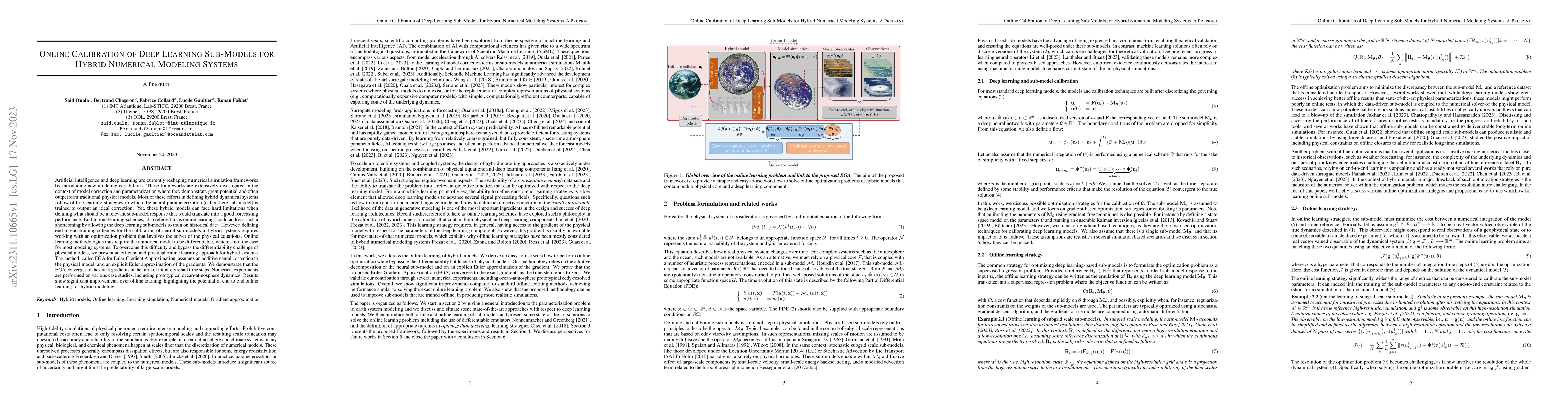
Artificial intelligence and deep learning are currently reshaping numerical simulation frameworks by introducing new modeling capabilities. These frameworks are extensively investigated in the conte...
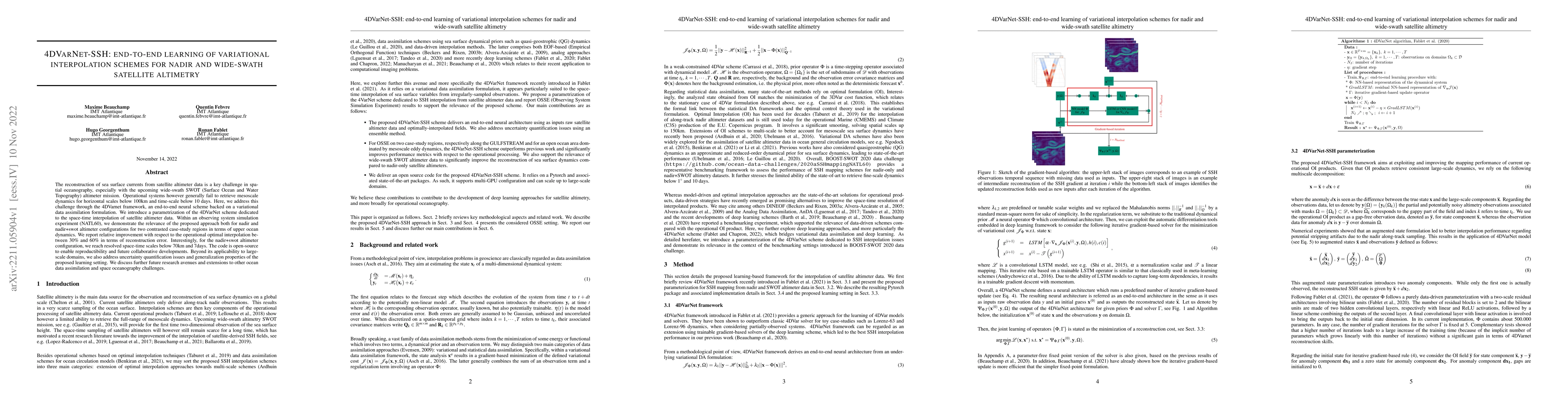
Historically, the interpolation of large geophysical datasets has been tackled using methods like Optimal Interpolation (OI) or model-based data assimilation schemes. However, the recent connection ...
In this paper, we propose a generic algorithm to train machine learning-based subgrid parametrizations online, i.e., with a posteriori loss functions, but for non-differentiable numerical solvers. T...
The ocean profoundly influences human activities and plays a critical role in climate regulation. Our understanding has improved over the last decades with the advent of satellite remote sensing dat...
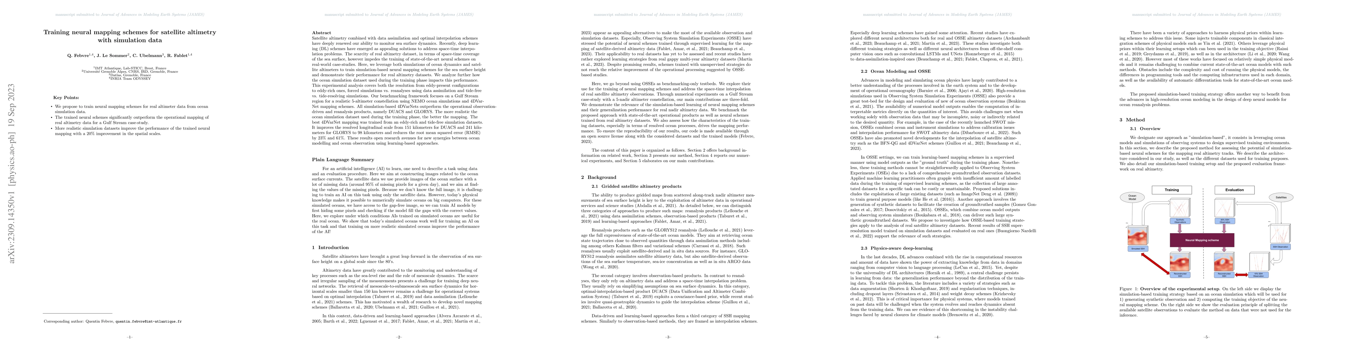
Satellite altimetry combined with data assimilation and optimal interpolation schemes have deeply renewed our ability to monitor sea surface dynamics. Recently, deep learning (DL) schemes have emerg...
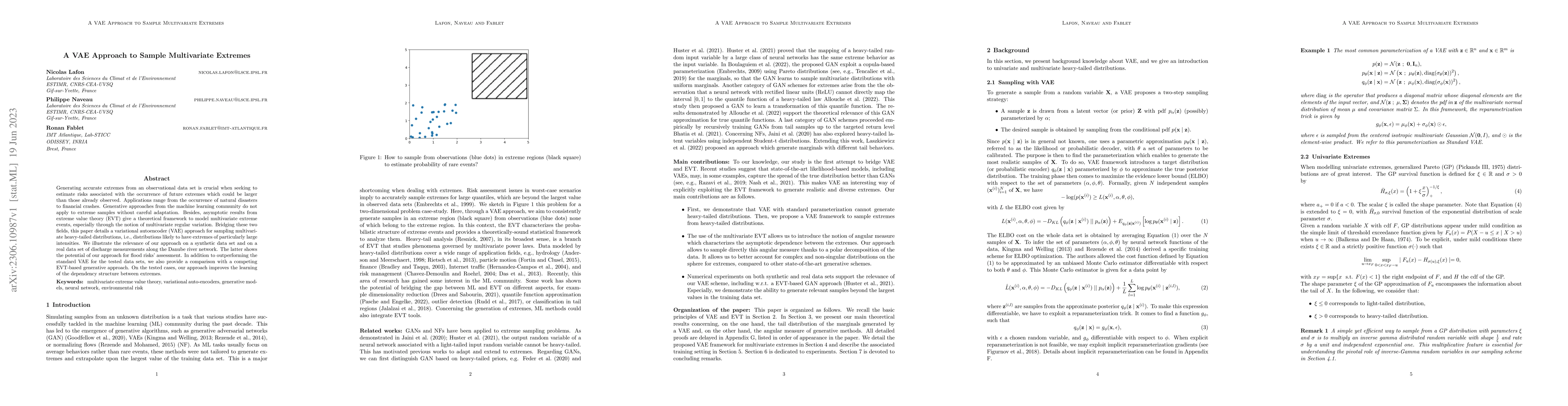
Generating accurate extremes from an observational data set is crucial when seeking to estimate risks associated with the occurrence of future extremes which could be larger than those already obser...
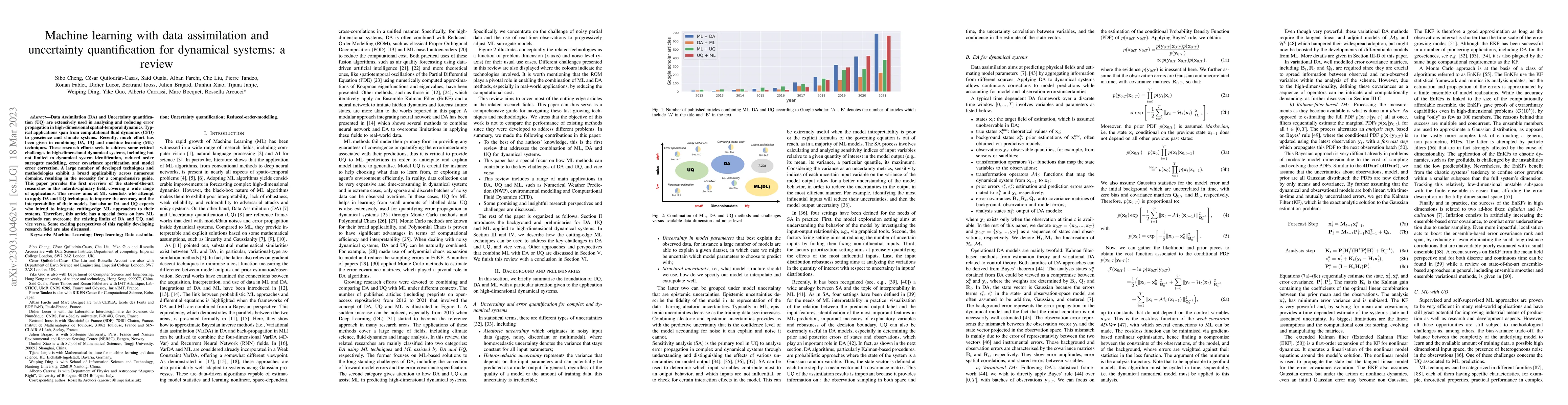
Data Assimilation (DA) and Uncertainty quantification (UQ) are extensively used in analysing and reducing error propagation in high-dimensional spatial-temporal dynamics. Typical applications span f...
Synthetic Aperture Radar is known to be able to provide high-resolution estimates of surface wind speed. These estimates usually rely on a Geophysical Model Function (GMF) that has difficulties acco...
Sea surface height (SSH) is a key geophysical parameter for monitoring and studying meso-scale surface ocean dynamics. For several decades, the mapping of SSH products at regional and global scales ...
Satellite altimetry is a unique way for direct observations of sea surface dynamics. This is however limited to the surface-constrained geostrophic component of sea surface velocities. Ageostrophic ...
Optimal Interpolation (OI) is a widely used, highly trusted algorithm for interpolation and reconstruction problems in geosciences. With the influx of more satellite missions, we have access to more...
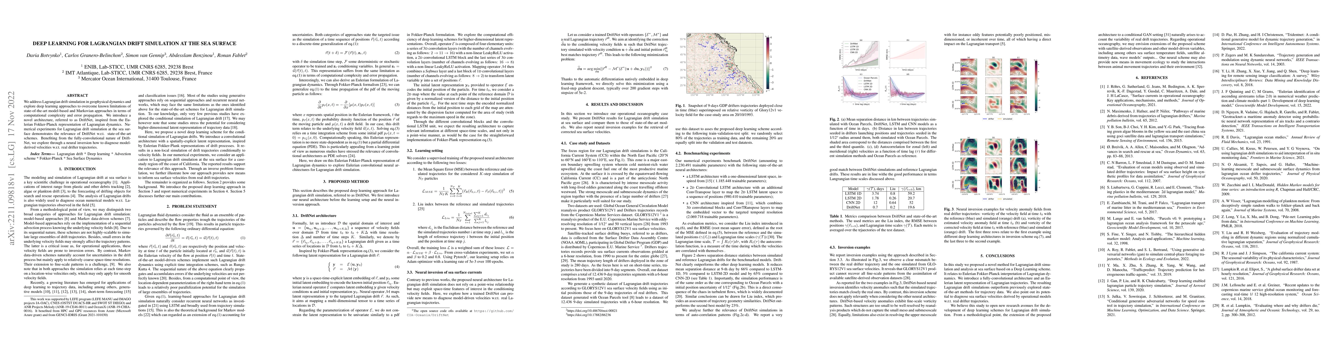
We address Lagrangian drift simulation in geophysical dynamics and explore deep learning approaches to overcome known limitations of state-of-the-art model-based and Markovian approaches in terms of...

The reconstruction of gap-free signals from observation data is a critical challenge for numerous application domains, such as geoscience and space-based earth observation, when the available sensor...
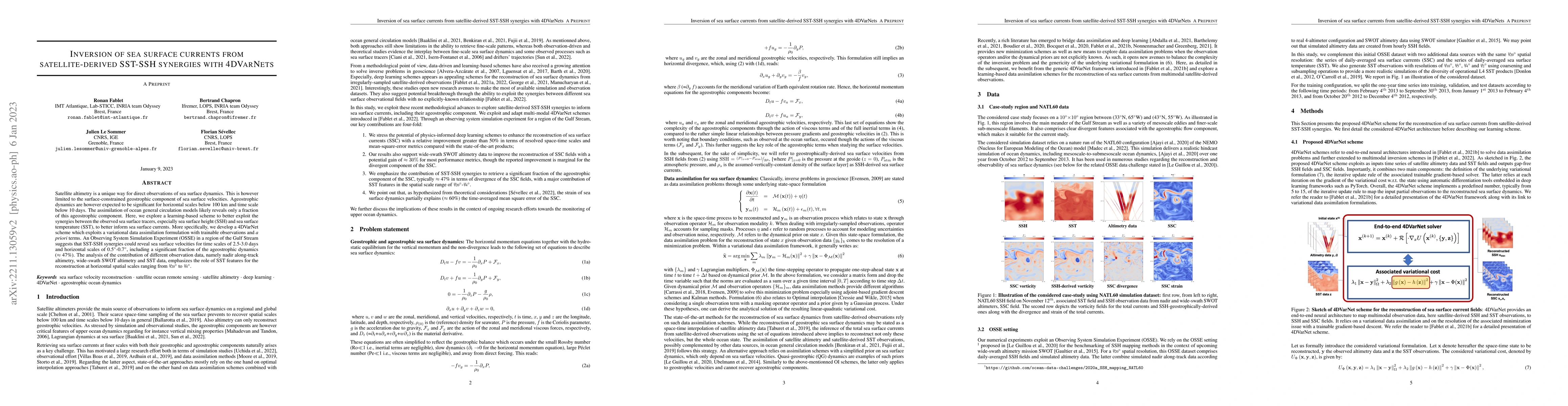
The reconstruction of sea surface currents from satellite altimeter data is a key challenge in spatial oceanography, especially with the upcoming wide-swath SWOT (Surface Ocean and Water Topography)...
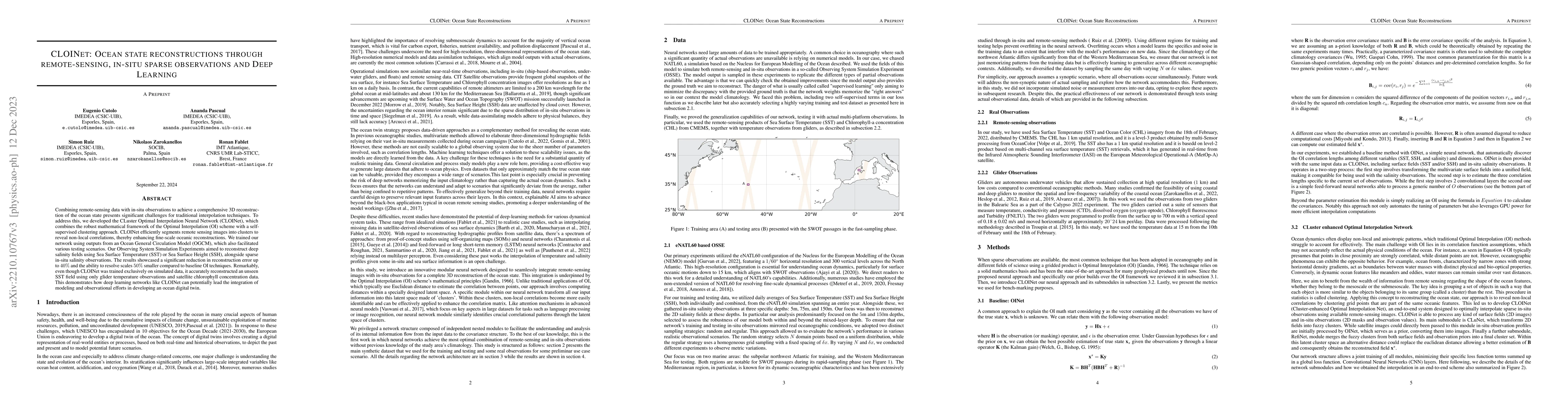
Combining remote-sensing data with in-situ observations to achieve a comprehensive 3D reconstruction of the ocean state presents significant challenges for traditional interpolation techniques. To a...
Wind speed retrieval at sea surface is of primary importance for scientific and operational applications. Besides weather models, in-situ measurements and remote sensing technologies, especially sat...
Remote sensing of rainfall events is critical for both operational and scientific needs, including for example weather forecasting, extreme flood mitigation, water cycle monitoring, etc. Ground-base...
Due to the irregular space-time sampling of sea surface observations, the reconstruction of sea surface dynamics is a challenging inverse problem. While satellite altimetry provides a direct observa...
The use of machine learning to build subgrid parametrizations for climate models is receiving growing attention. State-of-the-art strategies address the problem as a supervised learning task and opt...
For numerous earth observation applications, one may benefit from various satellite sensors to address the reconstruction of some process or information of interest. A variety of satellite sensors d...
The complexity of real-world geophysical systems is often compounded by the fact that the observed measurements depend on hidden variables. These latent variables include unresolved small scales and...
Modeling the subgrid-scale dynamics of reduced models is a long standing open problem that finds application in ocean, atmosphere and climate predictions where direct numerical simulation (DNS) is i...
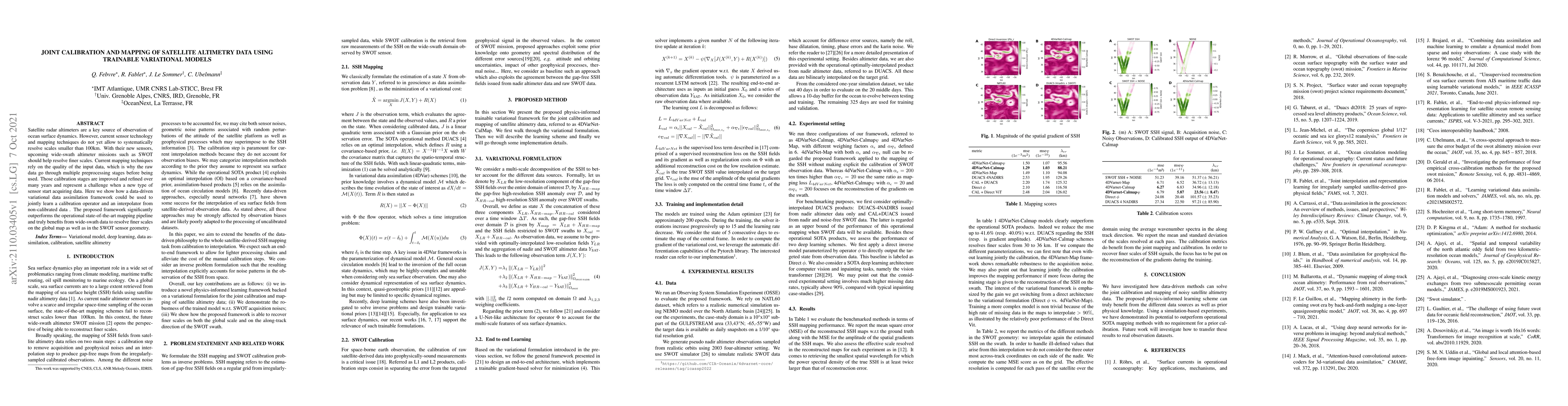
Satellite radar altimeters are a key source of observation of ocean surface dynamics. However, current sensor technology and mapping techniques do not yet allow to systematically resolve scales smal...
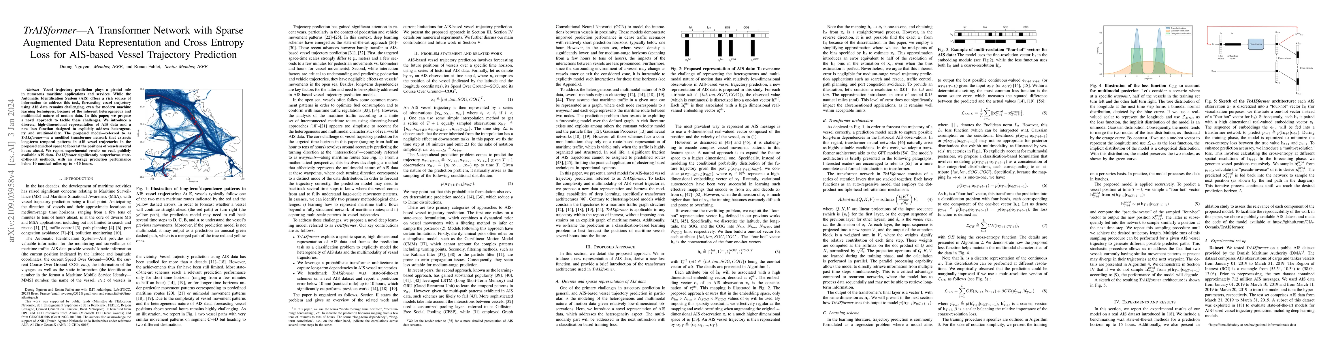
Vessel trajectory prediction plays a pivotal role in numerous maritime applications and services. While the Automatic Identification System (AIS) offers a rich source of information to address this ...
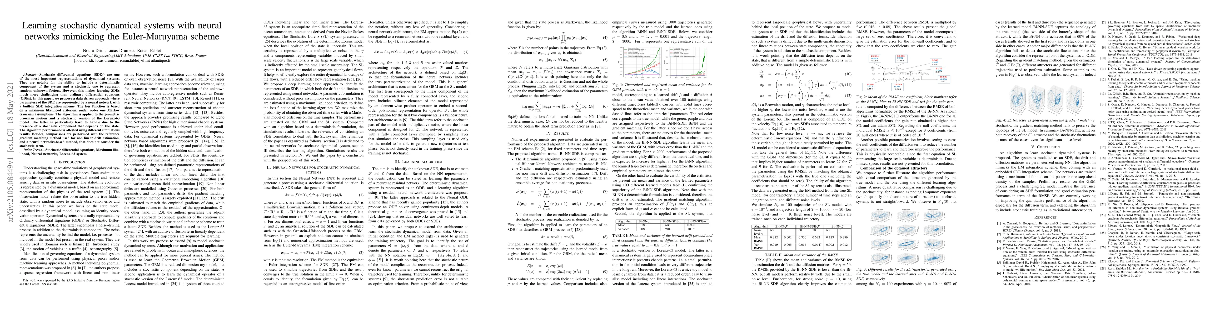
Stochastic differential equations (SDEs) are one of the most important representations of dynamical systems. They are notable for the ability to include a deterministic component of the system and a...
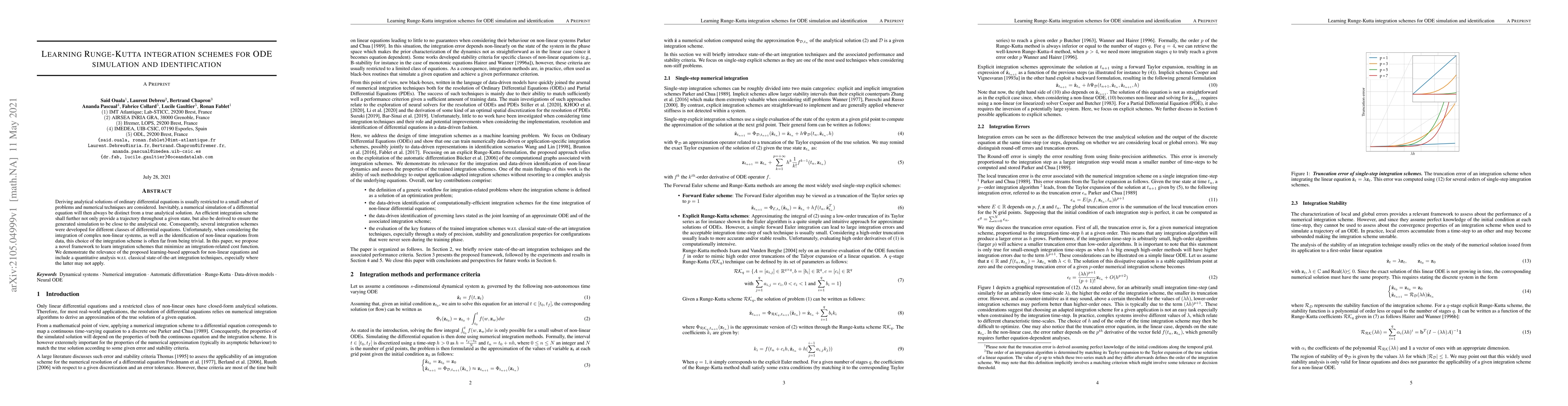
Deriving analytical solutions of ordinary differential equations is usually restricted to a small subset of problems and numerical techniques are considered. Inevitably, a numerical simulation of a ...
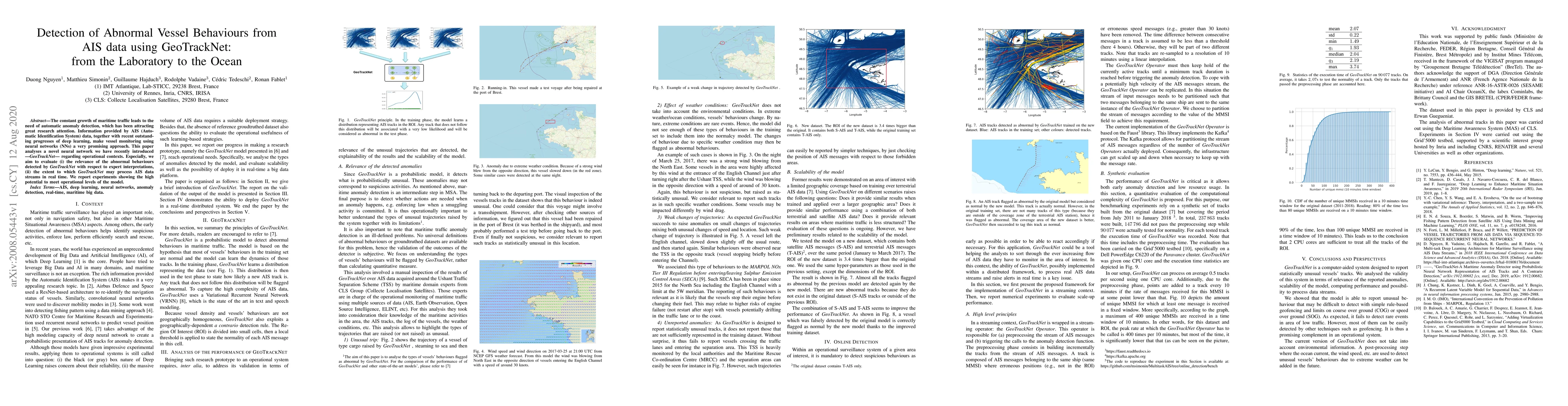
The constant growth of maritime traffic leads to the need of automatic anomaly detection, which has been attracting great research attention. Information provided by AIS (Automatic Identification Sy...
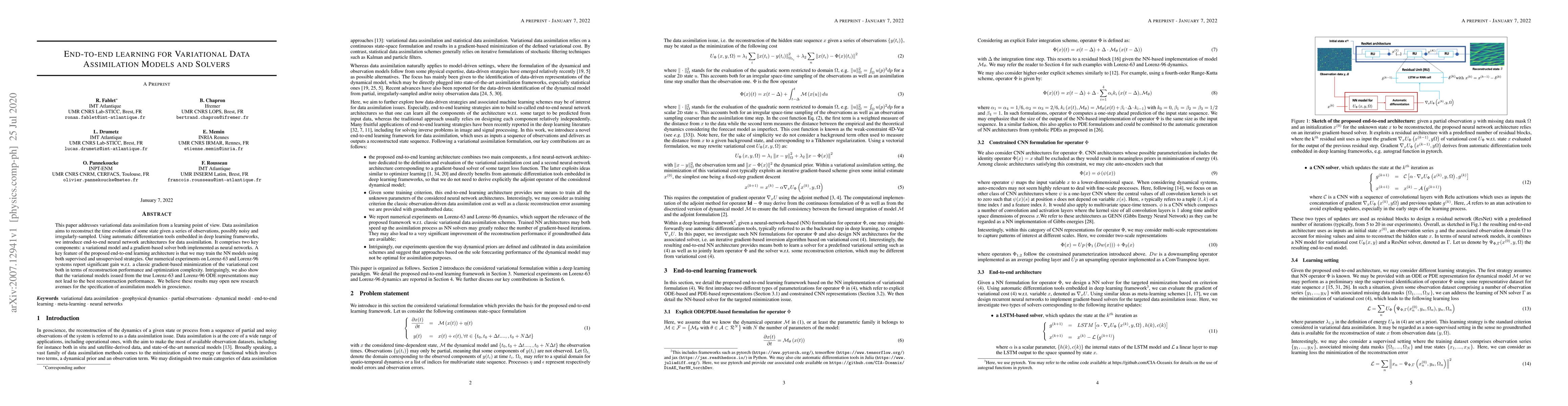
This paper addresses variational data assimilation from a learning point of view. Data assimilation aims to reconstruct the time evolution of some state given a series of observations, possibly nois...
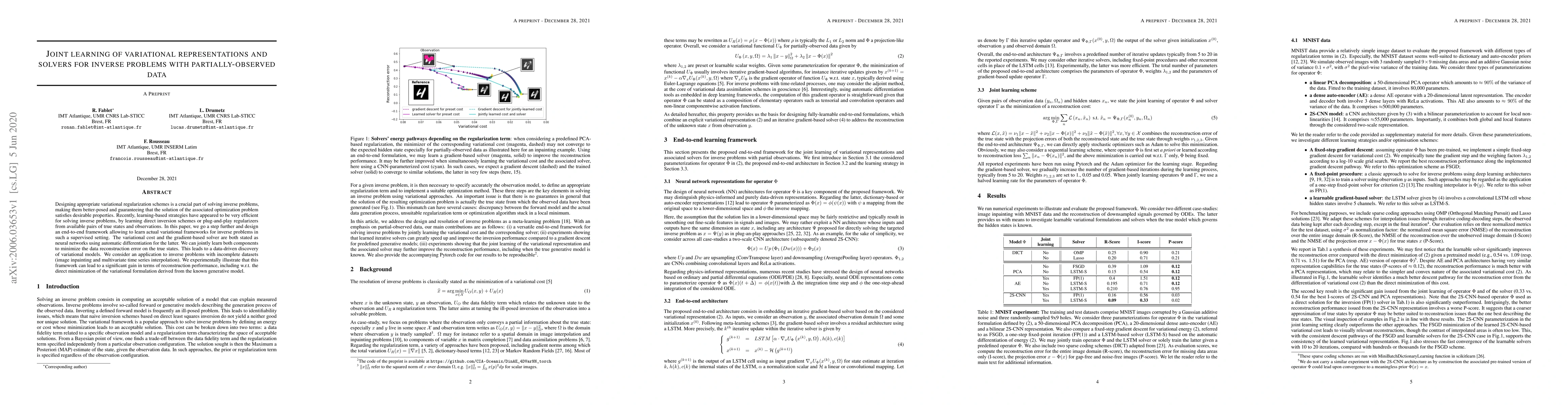
Designing appropriate variational regularization schemes is a crucial part of solving inverse problems, making them better-posed and guaranteeing that the solution of the associated optimization pro...
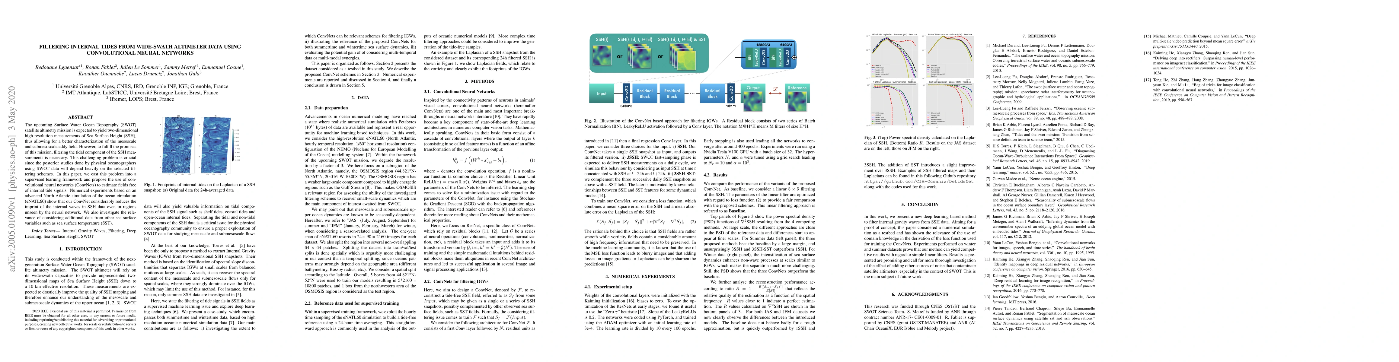
The upcoming Surface Water Ocean Topography (SWOT) satellite altimetry mission is expected to yield two-dimensional high-resolution measurements of Sea Surface Height (SSH), thus allowing for a bett...
Bridging physics and deep learning is a topical challenge. While deep learning frameworks open avenues in physical science, the design of physically-consistent deep neural network architectures is a...
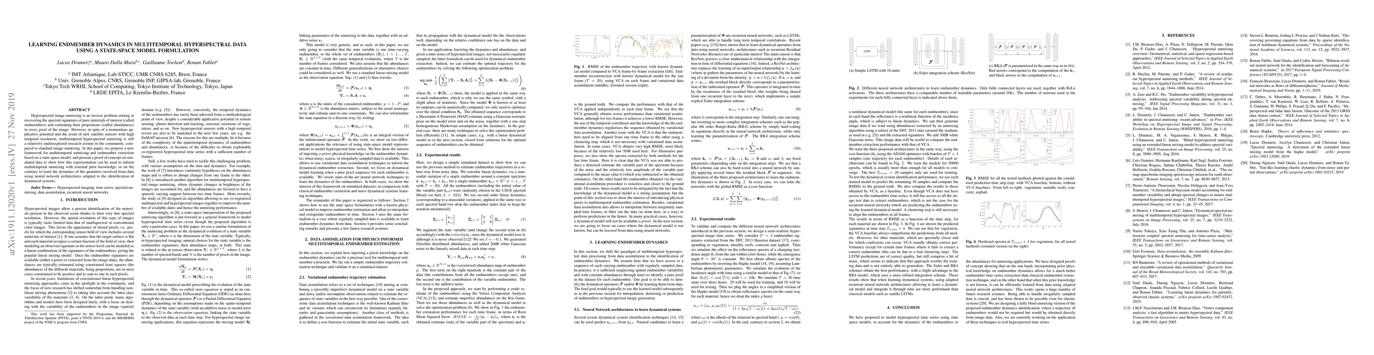
Hyperspectral image unmixing is an inverse problem aiming at recovering the spectral signatures of pure materials of interest (called endmembers) and estimating their proportions (called abundances)...

We introduce a new strategy designed to help physicists discover hidden laws governing dynamical systems. We propose to use machine learning automatic differentiation libraries to develop hybrid num...
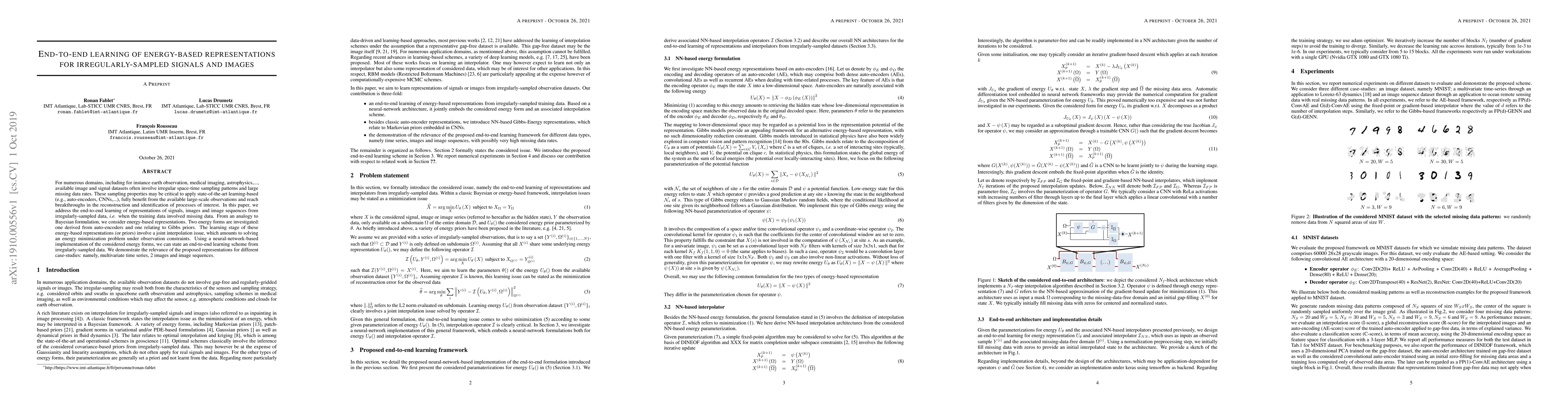
For numerous domains, including for instance earth observation, medical imaging, astrophysics,..., available image and signal datasets often involve irregular space-time sampling patterns and large ...
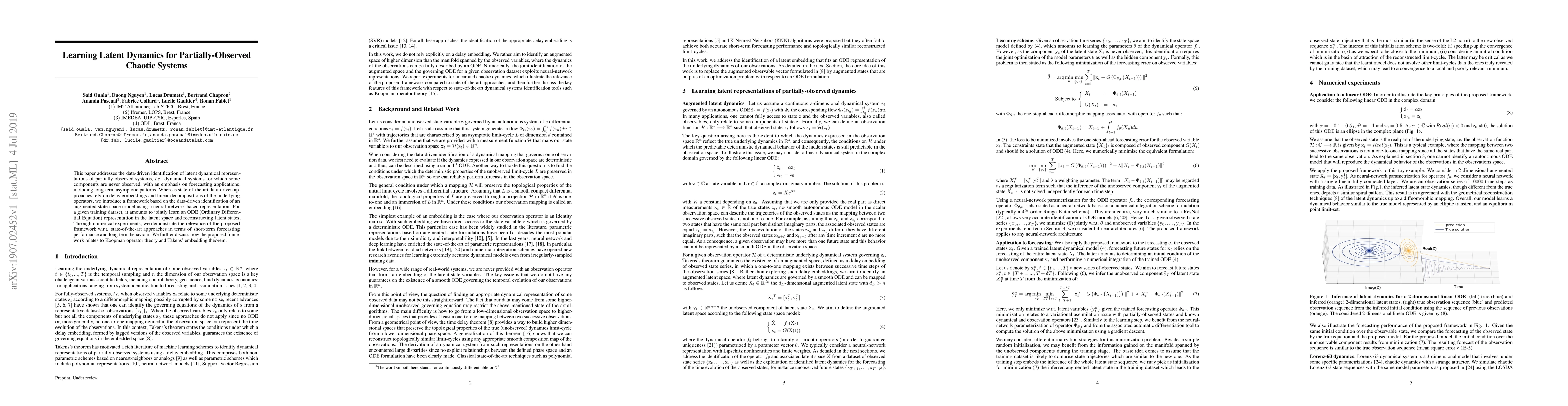
This paper addresses the data-driven identification of latent dynamical representations of partially-observed systems, i.e., dynamical systems for which some components are never observed, with an e...
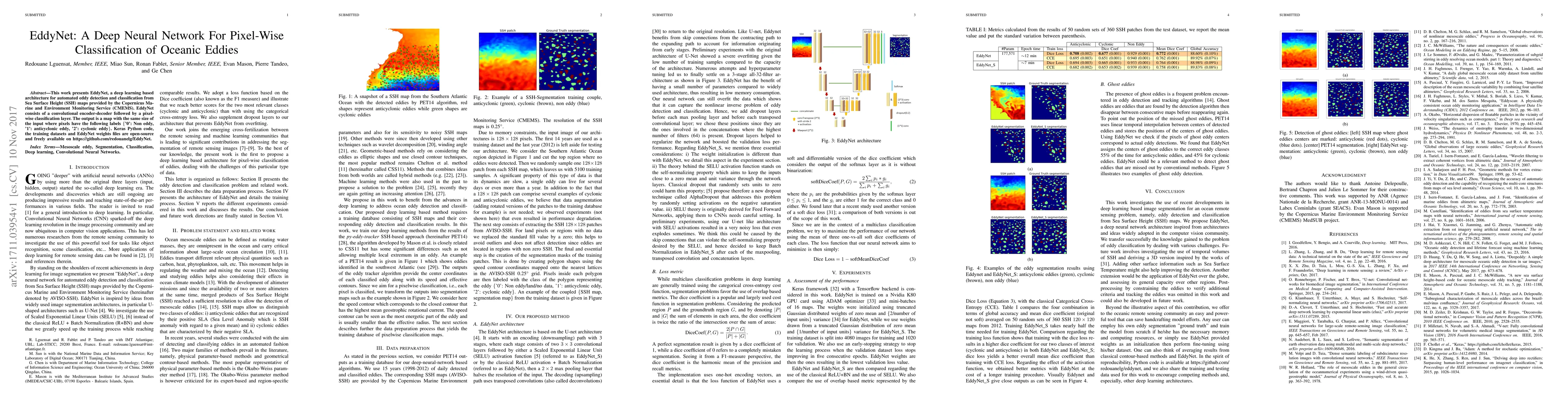
This work presents EddyNet, a deep learning based architecture for automated eddy detection and classification from Sea Surface Height (SSH) maps provided by the Copernicus Marine and Environment Mo...
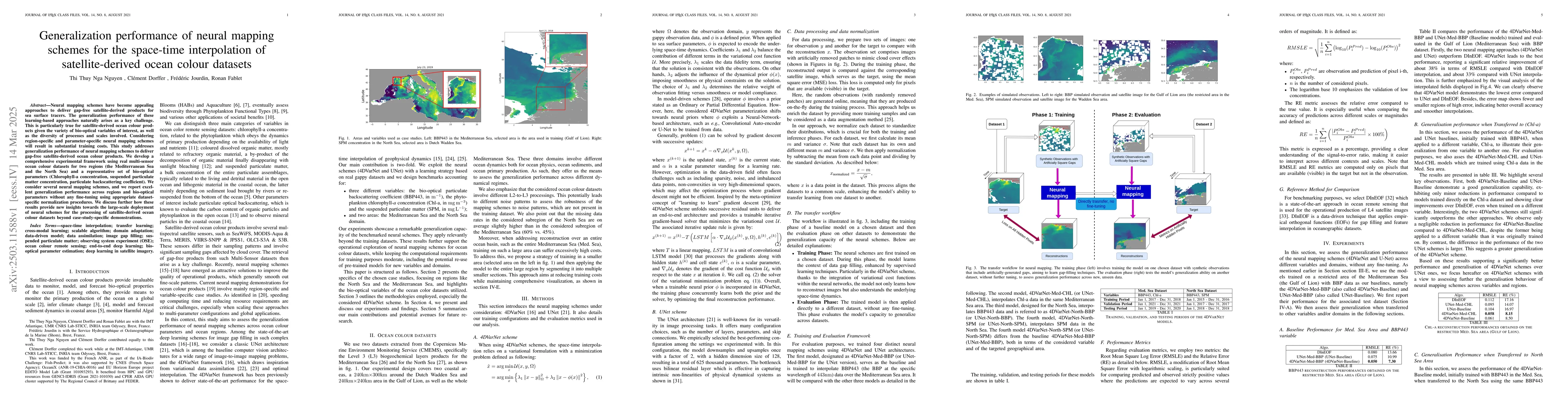
Neural mapping schemes have become appealing approaches to deliver gap-free satellite-derived products for sea surface tracers. The generalization performance of these learning-based approaches natura...
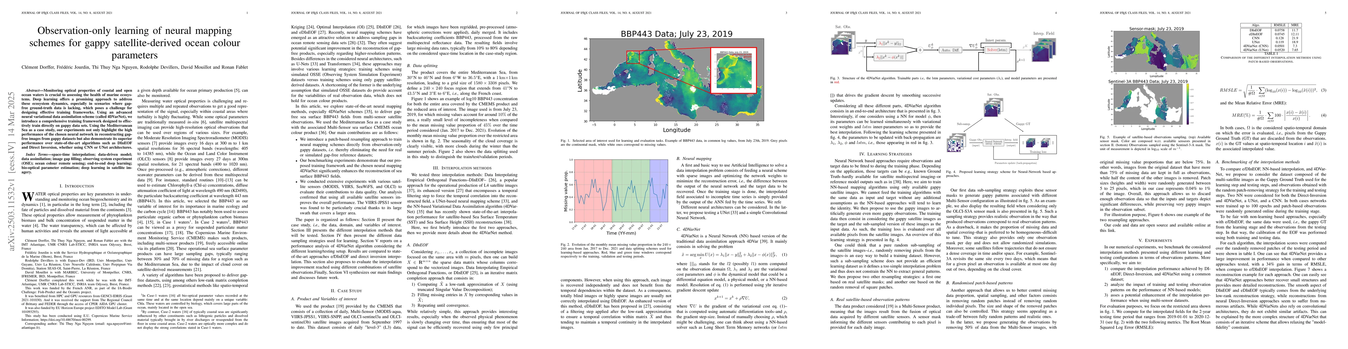
Monitoring optical properties of coastal and open ocean waters is crucial to assessing the health of marine ecosystems. Deep learning offers a promising approach to address these ecosystem dynamics, e...
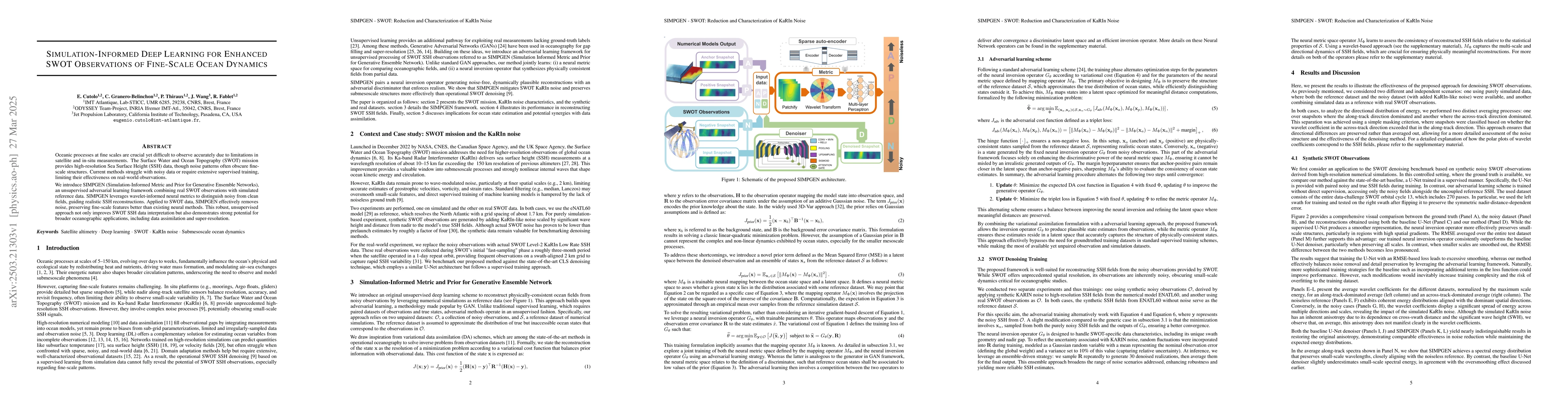
Oceanic processes at fine scales are crucial yet difficult to observe accurately due to limitations in satellite and in-situ measurements. The Surface Water and Ocean Topography (SWOT) mission provide...
We present a differentiable extension of the VEROS ocean model, enabling automatic differentiation through its dynamical core. We describe the key modifications required to make the model fully compat...

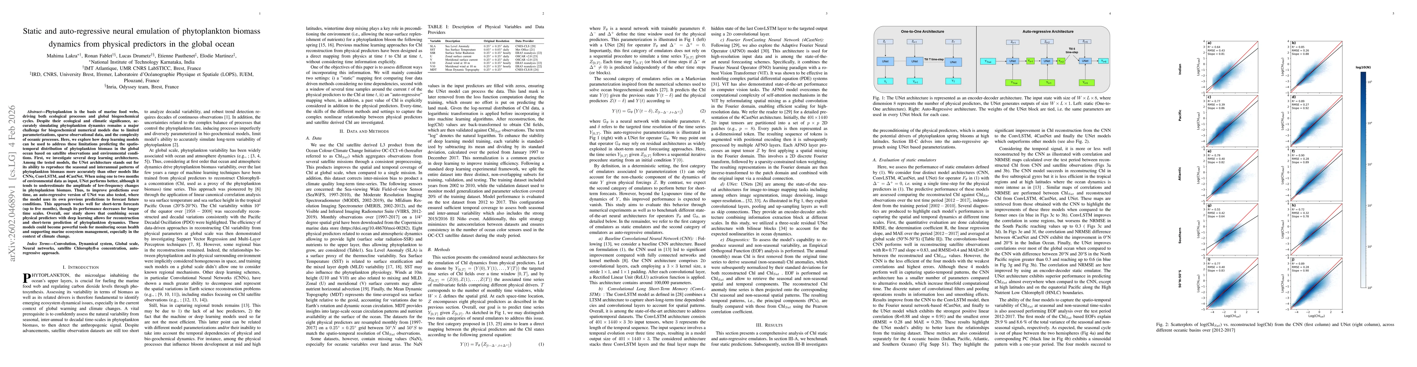
We present an end-to-end deep learning framework for short-term forecasting of global sea surface dynamics based on sparse satellite altimetry data. Building on two state-of-the-art architectures: U-N...
Inverse problems are often ill-posed and require optimization schemes with strong stability and convergence guarantees. While learning-based approaches such as deep unrolling and meta-learning achieve...
We introduce an unsupervised approach for constructing a global reference system by learning, in the ambient space, vector fields that span the tangent spaces of an unknown data manifold. In contrast ...
Phytoplankton is the basis of marine food webs, driving both ecological processes and global biogeochemical cycles. Despite their ecological and climatic significance, accurately simulating phytoplank...
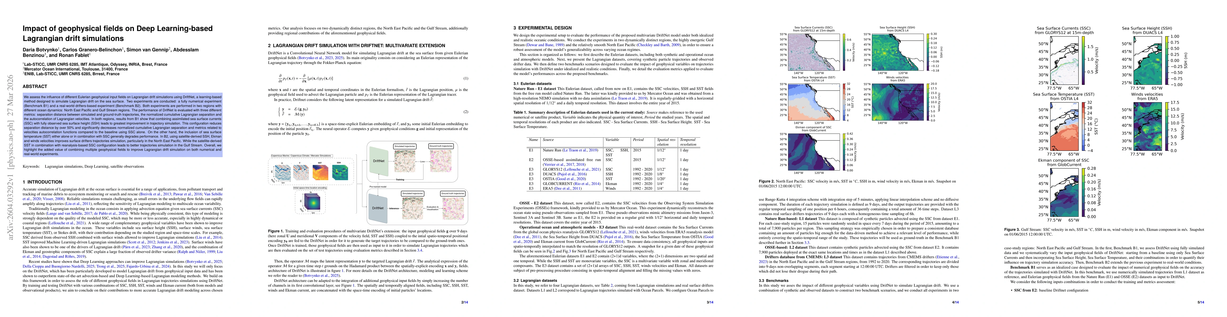
We assess the influence of different Eulerian geophysical input fields on Lagrangian drift simulations using DriftNet, a learning-based method designed to simulate Lagrangian drift on the sea surface....
Accurately reconstructing and forecasting ocean fields from sparse observations is critical for both operational and scientific purposes. Optimizing sensor placement to maximize reconstruction skill r...
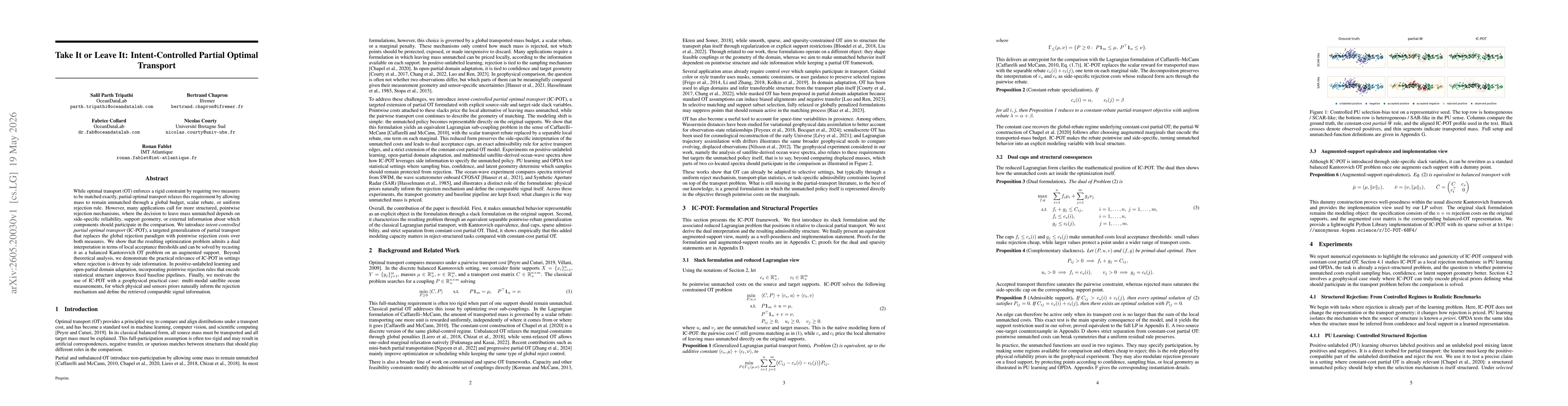
While optimal transport (OT) enforces a rigid constraint by requiring two measures to be matched exactly, partial optimal transport relaxes this requirement by allowing mass to remain unmatched throug...