S. Vignudelli

7 papers on arXiv

Academic Profile

Name: S. Vignudelli
Total Papers: 139

Statistics

arXiv Papers 7
Total Publications 139

Papers on arXiv

Thumbnail for Modeling Envisat RA-2 waveforms in the coastal zone: Case study of calm
  water contamination

Modeling Envisat RA-2 waveforms in the coastal zone: Case study of calm water contamination

This letter examines waveform data from the Envisat RA-2 as it passes regularly over Pianosa (a 10-km 2 island in the northwestern Mediterranean). Forty-six repeat passes were analyzed, with most sh...

Thumbnail for Validation of Sentinel-3a Sral Coastal Sea Level Data at High Posting
  Rate: 80Hz

Validation of Sentinel-3a Sral Coastal Sea Level Data at High Posting Rate: 80Hz

Altimetry data of two and a half years (June 2016-November 2018) of Sentinel 3A SRAL were validated at the sampling frequency of 80 Hz. The study areas are three coastal sites in Spain: Huelva (HU) ...

Thumbnail for Coastal altimetry products in the strait of Gibraltar

Coastal altimetry products in the strait of Gibraltar

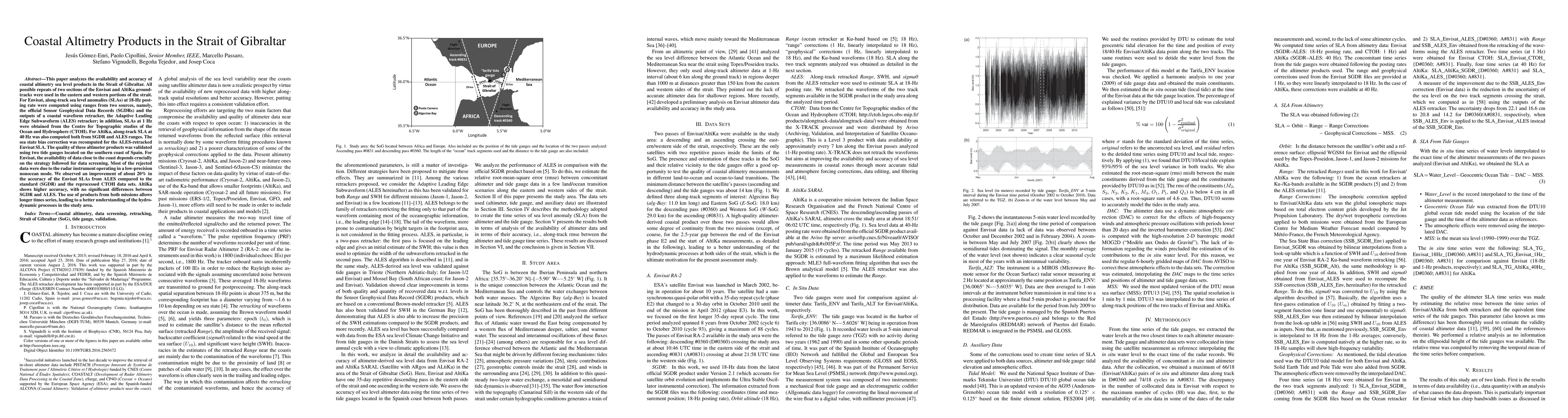
This paper analyzes the availability and accuracy of coastal altimetry sea level products in the Strait of Gibraltar. All possible repeats of two sections of the Envisat and AltiKa ground-tracks wer...

Thumbnail for Coherent ranging with Envisat radar altimeter: a new perspective in
  analyzing altimeter data using Doppler Processing

Coherent ranging with Envisat radar altimeter: a new perspective in analyzing altimeter data using Doppler Processing

ESA's Envisat mission carried a RA-2 radar altimeter since its launch in 2002 to sense sea state and especially measure sea surface height (SSH). The onboard processing combined multiple echoes inco...

Thumbnail for Comparison of the X-TRACK altimetry estimated currents with moored ADCP
  and HF radar observations on the West Florida Shelf

Comparison of the X-TRACK altimetry estimated currents with moored ADCP and HF radar observations on the West Florida Shelf

The performance of coastal altimetry over a wide continental shelf is assessed using multiple-year ocean current observations by moored Acoustic Doppler Current Profilers (ADCP) and high frequency (...

Thumbnail for Wind-induced Cross-Strait Sea Level Variability in the Strait of
  Gibraltar using Coastal Altimetry and In-Situ Measurements

Wind-induced Cross-Strait Sea Level Variability in the Strait of Gibraltar using Coastal Altimetry and In-Situ Measurements

In this work, we retracked altimeter waveforms of ESA satellites. ERS2 RA and Envisat RA2 from descending track 0360 over the eastern side of the Strait of Gibraltar using the Adaptive Leading Edge ...

Thumbnail for Assessment of Retracked Ocean Parameters from Sentinel 3A Synthetic
  Aperture Radar (SAR) Mode Altimetry over the Marginal Seas at Southeast Asia

Assessment of Retracked Ocean Parameters from Sentinel 3A Synthetic Aperture Radar (SAR) Mode Altimetry over the Marginal Seas at Southeast Asia

This paper presents the assessment of altimetric data from Sentinel-3A satellite operating in Synthetic Aperture Radar (SAR) mode for sea level research studies and applications over the largest arc...

This website uses cookies to ensure you get the best experience. Learn more