ArxivLens
S
Researcher

Santiago Peña Luque

5 papers on arXiv

5 arXiv Papers
3 Total Publications
Profile

Academic Profile

Name Santiago Peña-Luque
Total Papers 3
Scholar Profile View on Semantic Scholar
Metrics

Statistics

5 arXiv Papers
3 Total Publications
Publications

Papers on arXiv

Thumbnail for Assimilation of SWOT Altimetry and Sentinel-1 Flood Extent Observations
  for Flood Reanalysis -- A Proof-of-Concept
arXiv
Assimilation of SWOT Altimetry and Sentinel-1 Flood Extent Observations for Flood Reanalysis -- A Proof-of-Concept

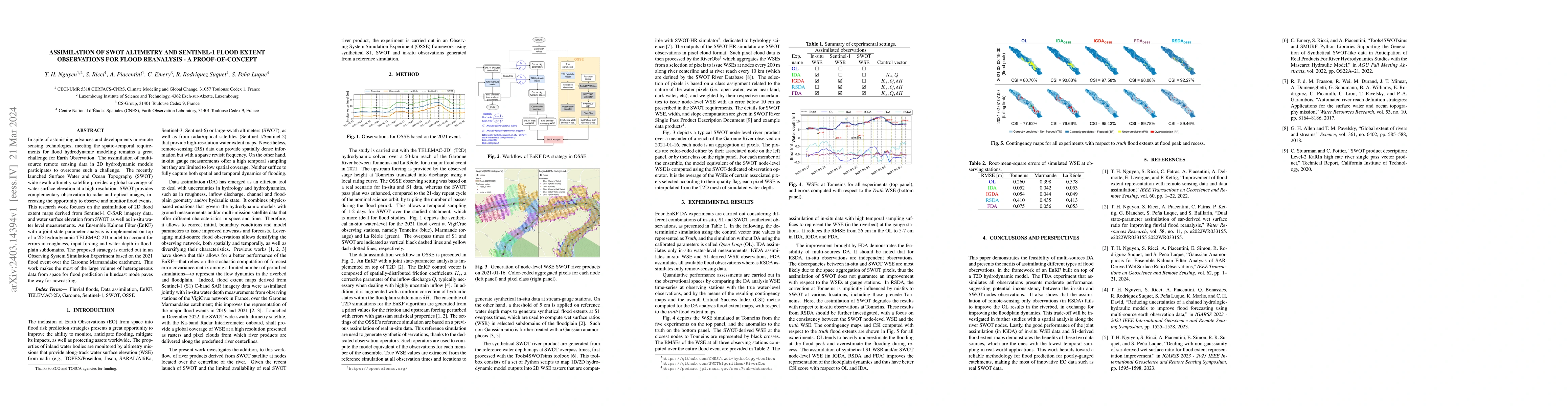
In spite of astonishing advances and developments in remote sensing technologies, meeting the spatio-temporal requirements for flood hydrodynamic modeling remains a great challenge for Earth Observa...

Thumbnail for Reducing Uncertainties of a Chained Hydrologic-hydraulic Model to
  Improve Flood Forecasting Using Multi-source Earth Observation Data
arXiv
Reducing Uncertainties of a Chained Hydrologic-hydraulic Model to Improve Flood Forecasting Using Multi-source Earth Observation Data

The challenges in operational flood forecasting lie in producing reliable forecasts given constrained computational resources and within processing times that are compatible with near-real-time fore...

Thumbnail for Dealing With Non-Gaussianity of SAR-derived Wet Surface Ratio for Flood
  Extent Representation Improvement
arXiv
Dealing With Non-Gaussianity of SAR-derived Wet Surface Ratio for Flood Extent Representation Improvement

Owing to advances in data assimilation, notably Ensemble Kalman Filter (EnKF), flood simulation and forecast capabilities have greatly improved in recent years. The motivation of the research work i...

Thumbnail for Gaussian Anamorphosis for Ensemble Kalman Filter Analysis of SAR-Derived
  Wet Surface Ratio Observations
arXiv
Gaussian Anamorphosis for Ensemble Kalman Filter Analysis of SAR-Derived Wet Surface Ratio Observations

Flood simulation and forecast capability have been greatly improved thanks to advances in data assimilation (DA) strategies incorporating various types of observations; many are derived from spatial...

Thumbnail for Assimilation of SWOT Altimetry Data for Riverine Flood Reanalysis: From
  Synthetic to Real Data
arXiv
Assimilation of SWOT Altimetry Data for Riverine Flood Reanalysis: From Synthetic to Real Data

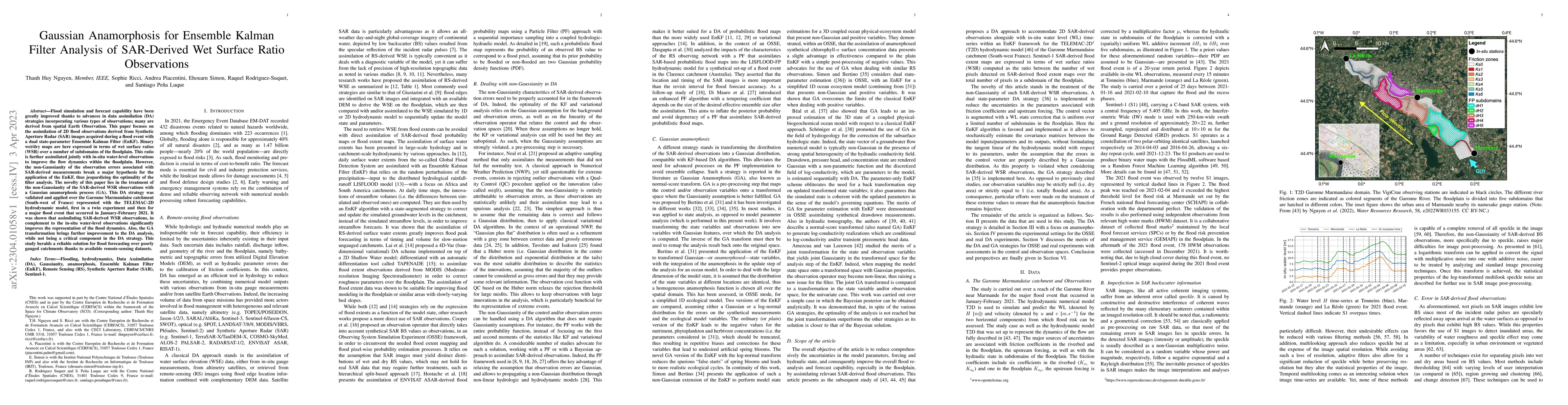
Floods are one of the most common and devastating natural disasters worldwide. The contribution of remote sensing is important for reducing the impact of flooding both during the event itself and for ...

This website uses cookies to ensure you get the best experience. Learn more