Academic Profile
Statistics
Similar Authors
Papers on arXiv
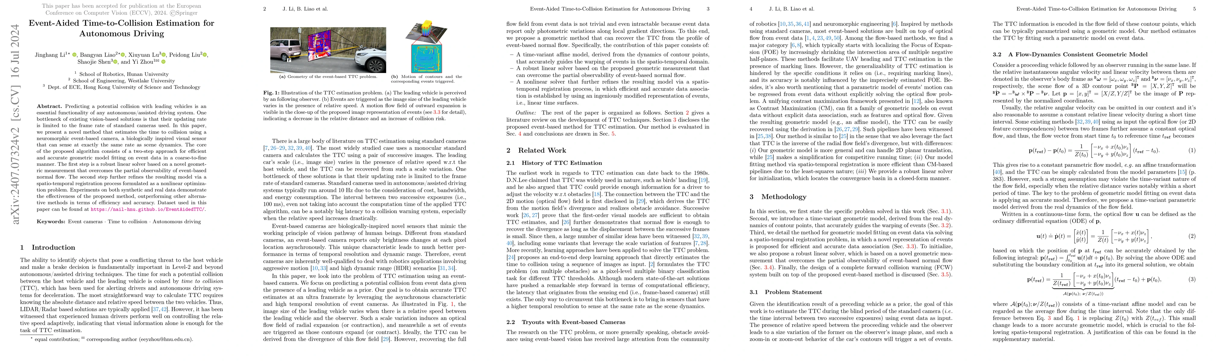
Predicting a potential collision with leading vehicles is an essential functionality of any autonomous/assisted driving system. One bottleneck of existing vision-based solutions is that their updating...
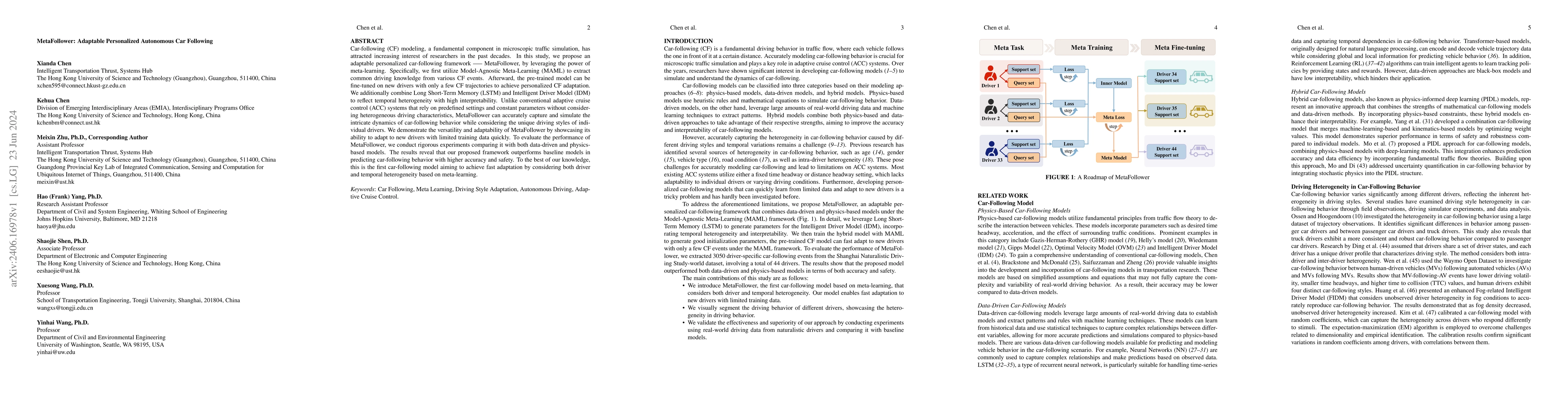
Car-following (CF) modeling, a fundamental component in microscopic traffic simulation, has attracted increasing interest of researchers in the past decades. In this study, we propose an adaptable per...
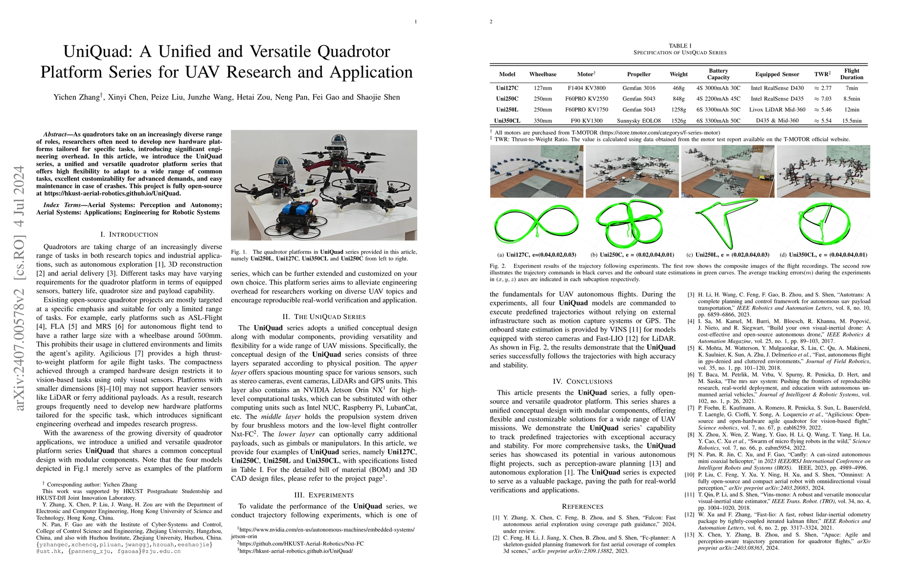
As quadrotors take on an increasingly diverse range of roles, researchers often need to develop new hardware platforms tailored for specific tasks, introducing significant engineering overhead. In t...
This paper introduces FALCON, a novel Fast Autonomous expLoration framework using COverage path guidaNce, which aims at setting a new performance benchmark in the field of autonomous aerial explorat...
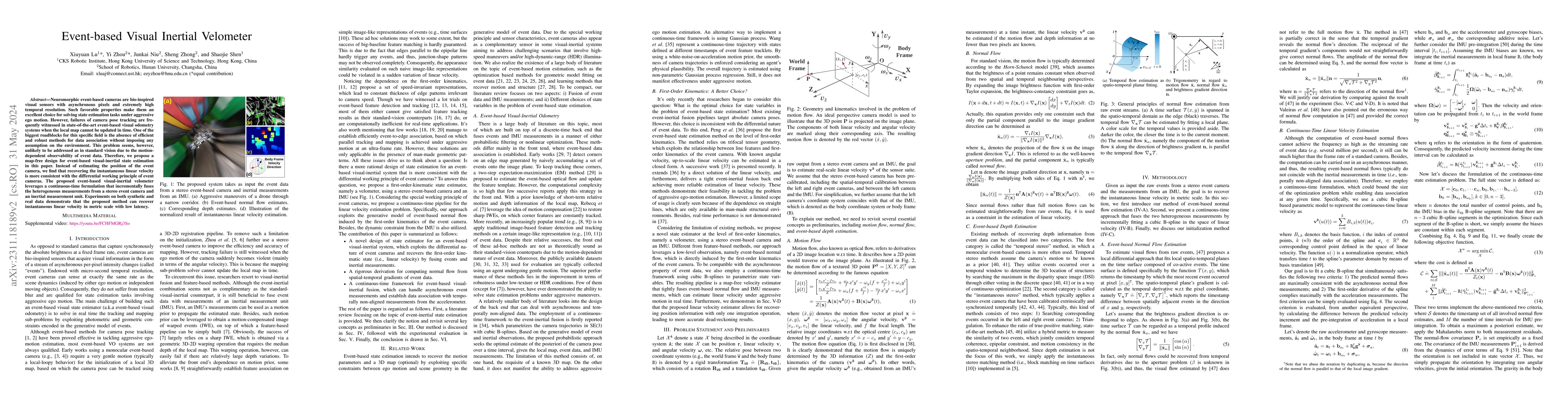
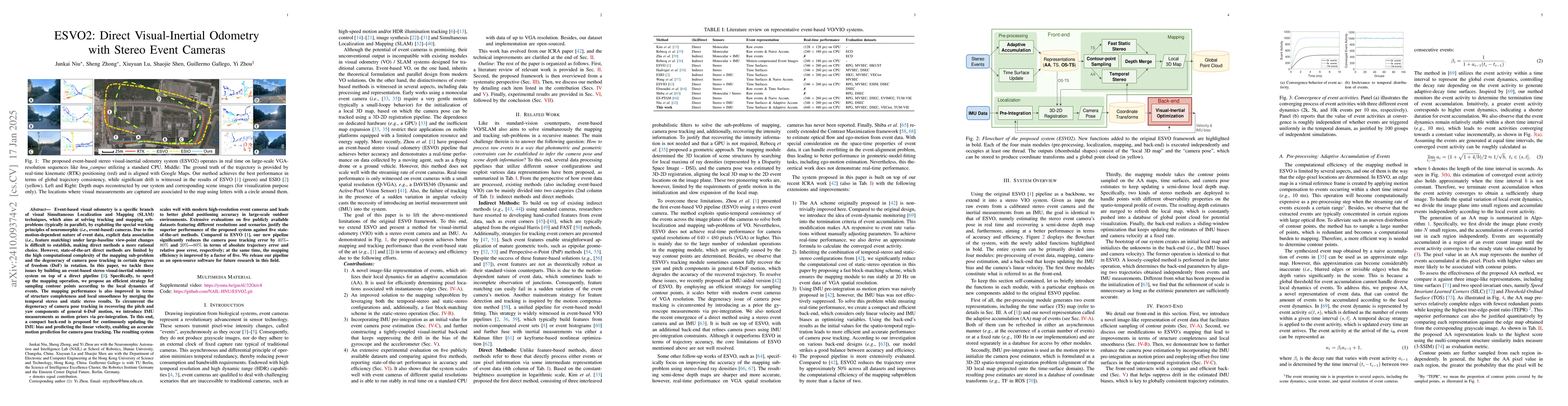
Neuromorphic vision sensors or event cameras have made the visual perception of extremely low reaction time possible, opening new avenues for high-dynamic robotics applications. These event cameras'...
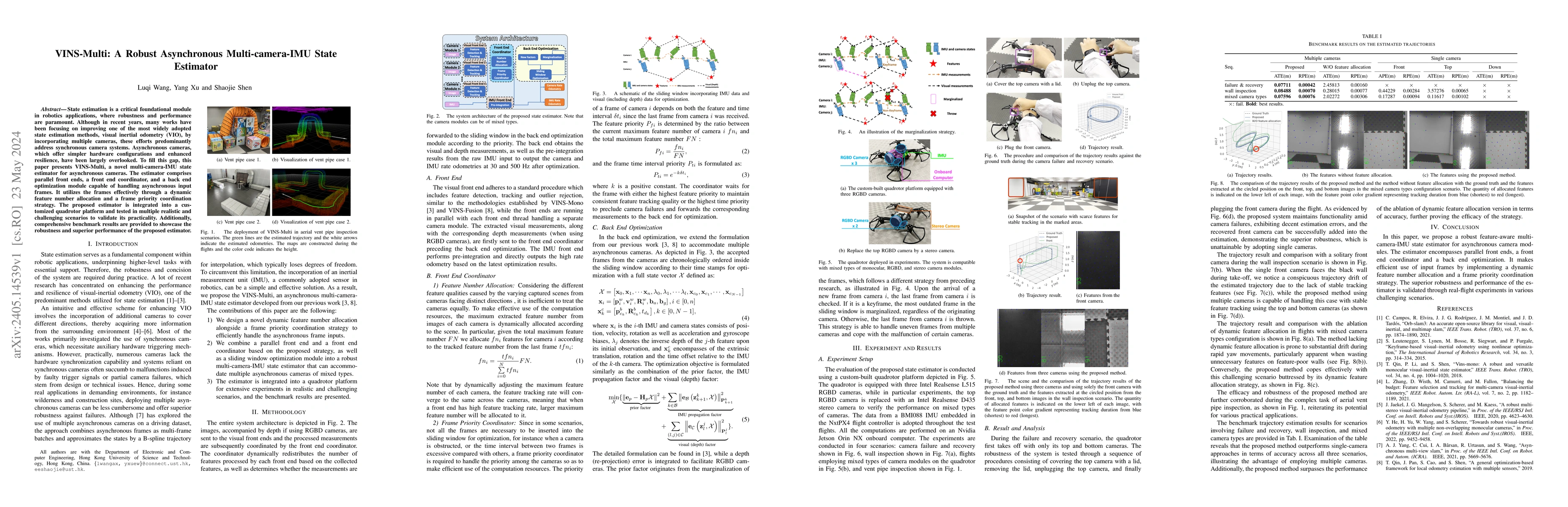
State estimation is a critical foundational module in robotics applications, where robustness and performance are paramount. Although in recent years, many works have been focusing on improving one ...
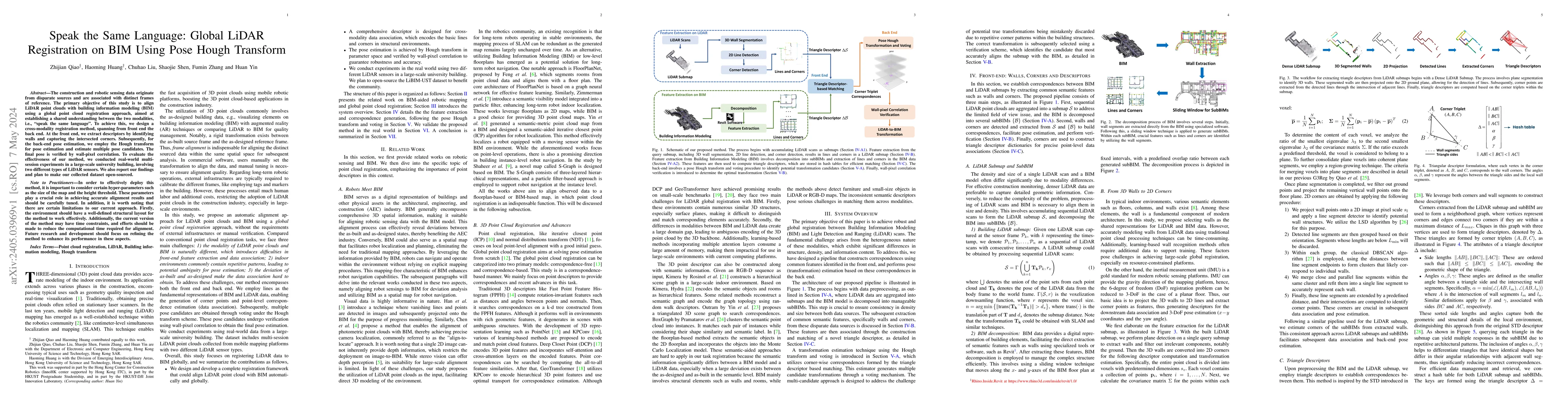
The construction and robotic sensing data originate from disparate sources and are associated with distinct frames of reference. The primary objective of this study is to align LiDAR point clouds wi...
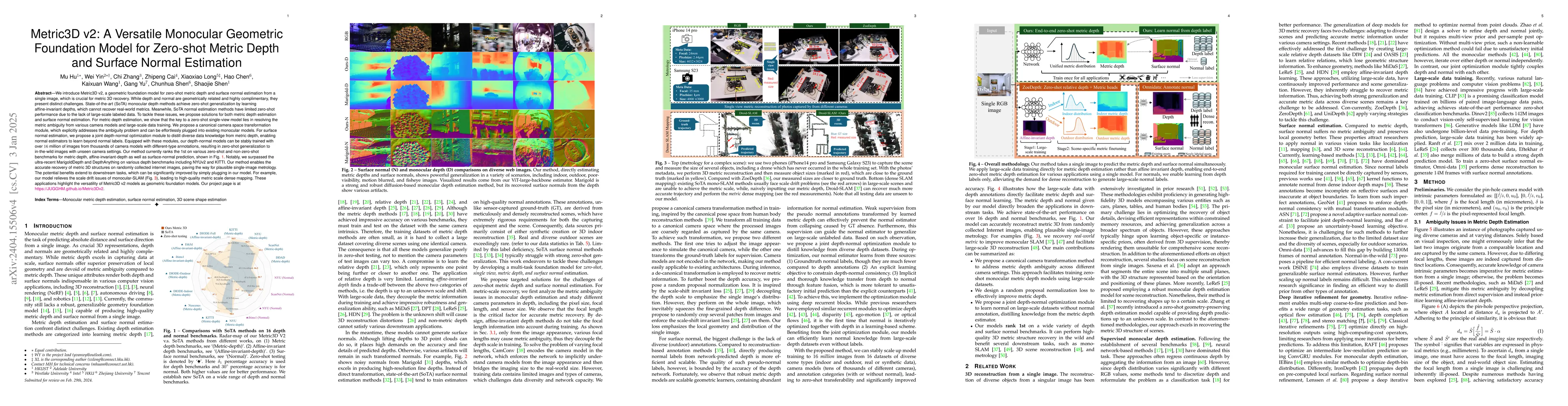
We introduce Metric3D v2, a geometric foundation model for zero-shot metric depth and surface normal estimation from a single image, which is crucial for metric 3D recovery. While depth and normal a...
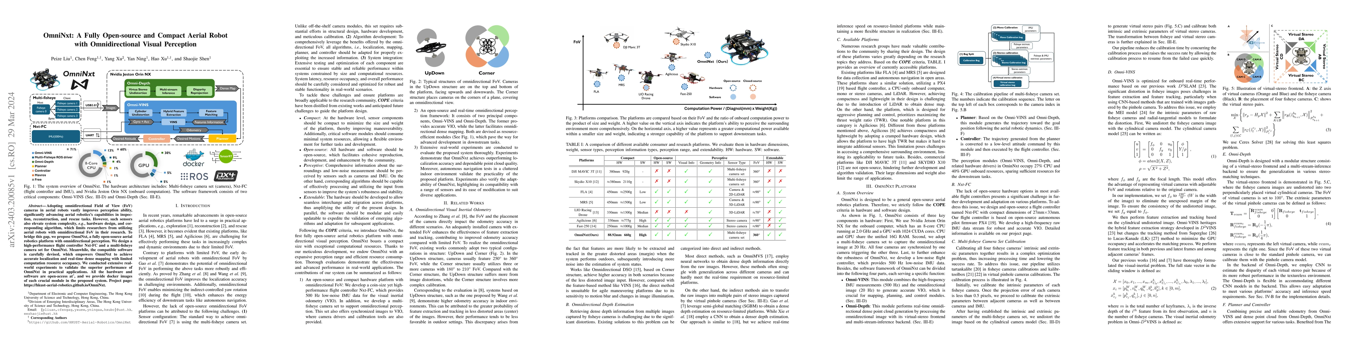
Adopting omnidirectional Field of View (FoV) cameras in aerial robots vastly improves perception ability, significantly advancing aerial robotics's capabilities in inspection, reconstruction, and re...
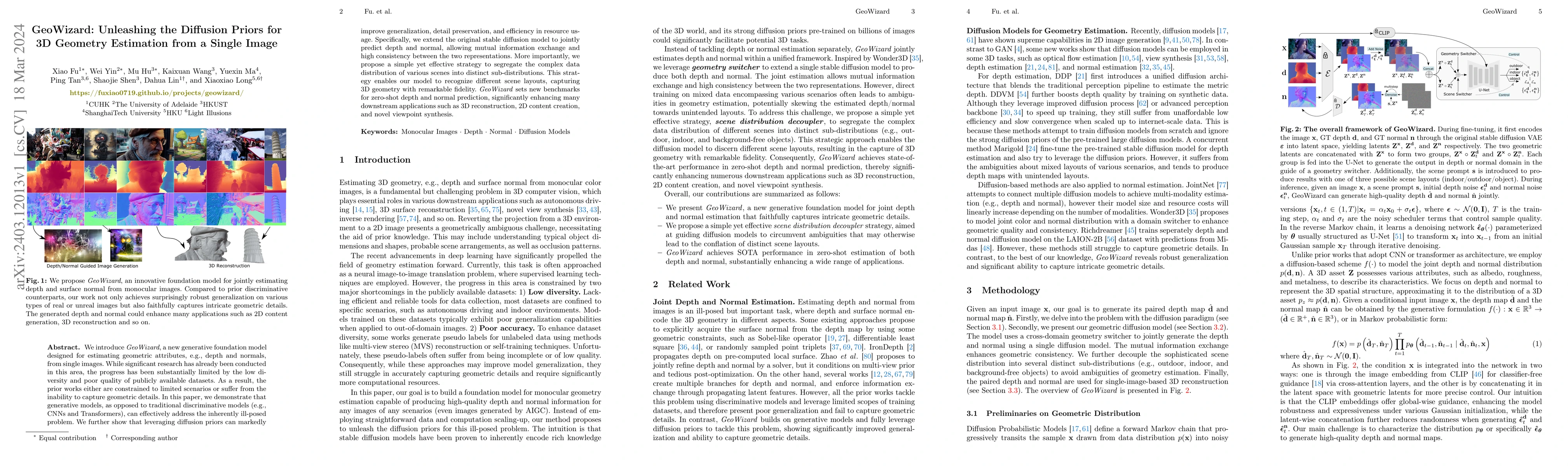
We introduce GeoWizard, a new generative foundation model designed for estimating geometric attributes, e.g., depth and normals, from single images. While significant research has already been condu...
Surface prediction and completion have been widely studied in various applications. Recently, research in surface completion has evolved from small objects to complex large-scale scenes. As a result...
In recent years, implicit online dense mapping methods have achieved high-quality reconstruction results, showcasing great potential in robotics, AR/VR, and digital twins applications. However, exis...
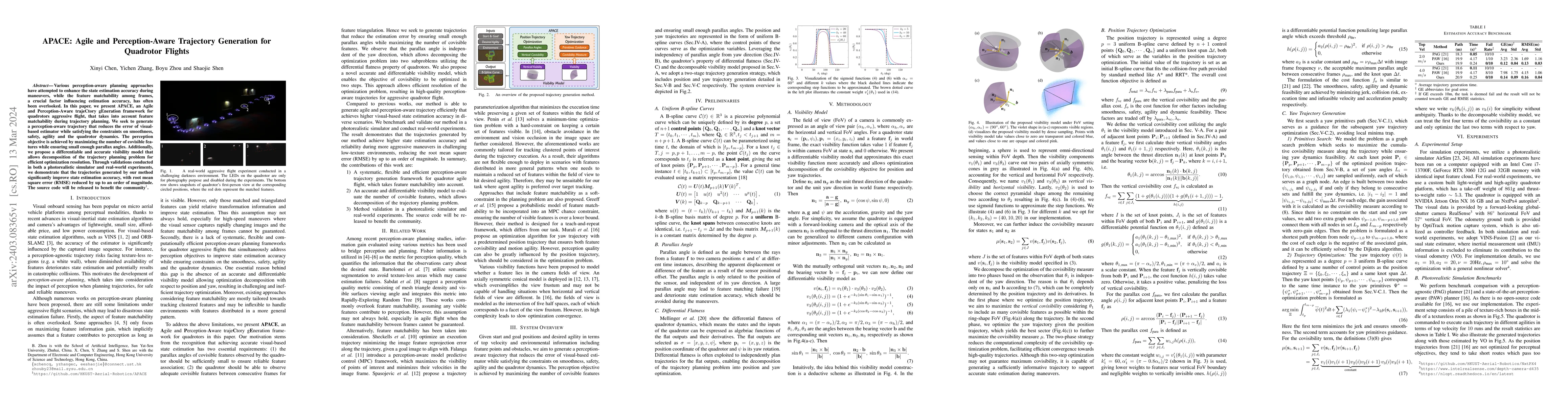
Various perception-aware planning approaches have attempted to enhance the state estimation accuracy during maneuvers, while the feature matchability among frames, a crucial factor influencing estim...
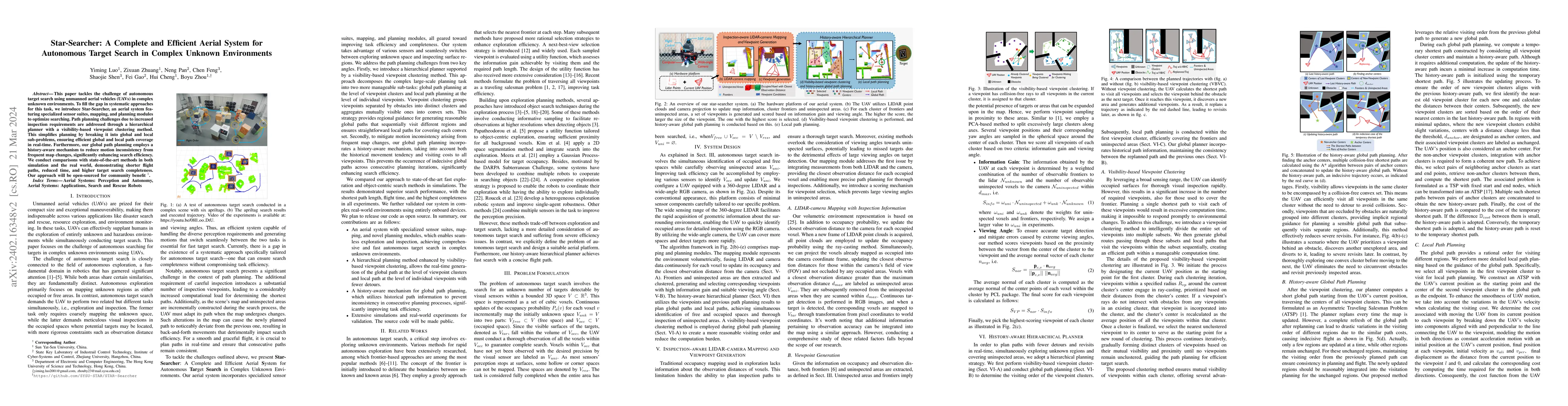
This paper tackles the challenge of autonomous target search using unmanned aerial vehicles (UAVs) in complex unknown environments. To fill the gap in systematic approaches for this task, we introdu...
While visual and laser-based simultaneous localization and mapping (SLAM) techniques have gained significant attention, radar SLAM remains a robust option for challenging conditions. This paper aims...
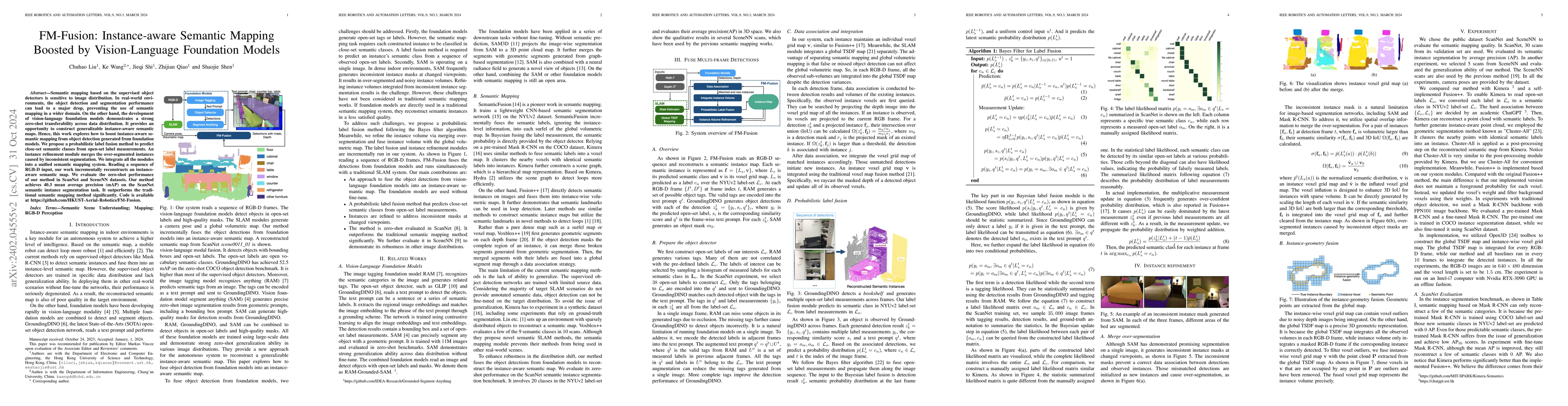
Semantic mapping based on the supervised object detectors is sensitive to image distribution. In real-world environments, the object detection and segmentation performance can lead to a major drop, ...
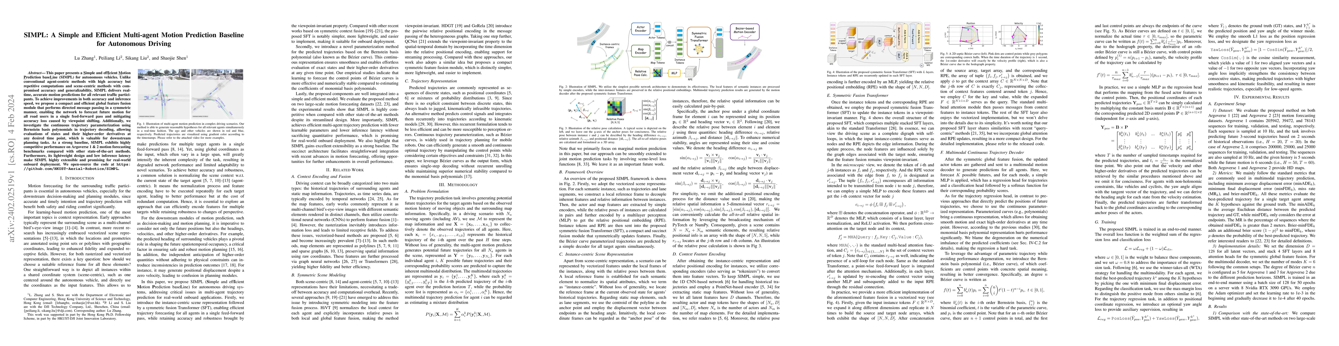
This paper presents a Simple and effIcient Motion Prediction baseLine (SIMPL) for autonomous vehicles. Unlike conventional agent-centric methods with high accuracy but repetitive computations and sc...
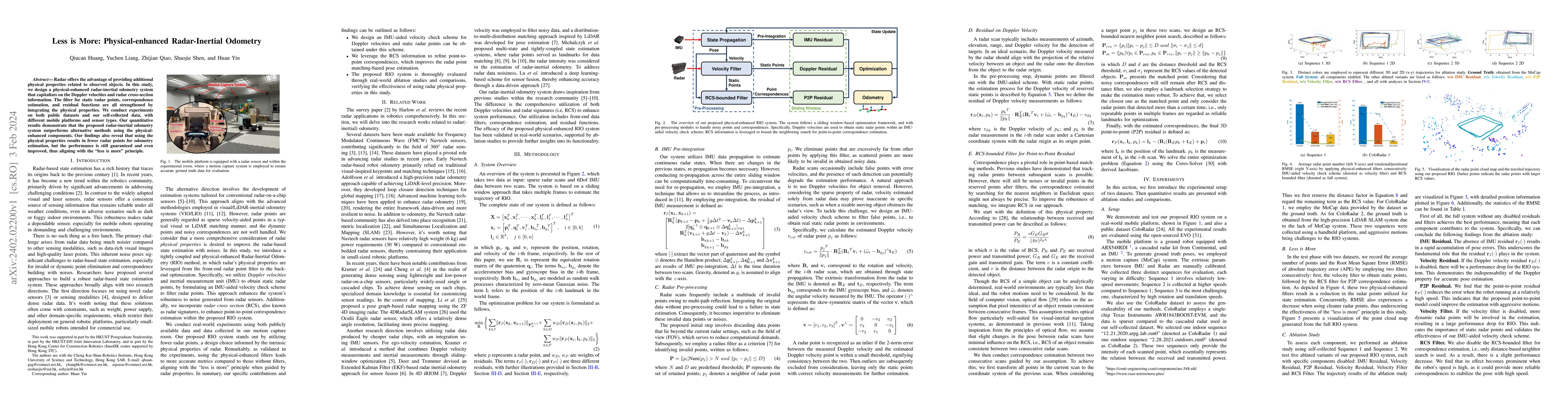
Radar offers the advantage of providing additional physical properties related to observed objects. In this study, we design a physical-enhanced radar-inertial odometry system that capitalizes on th...
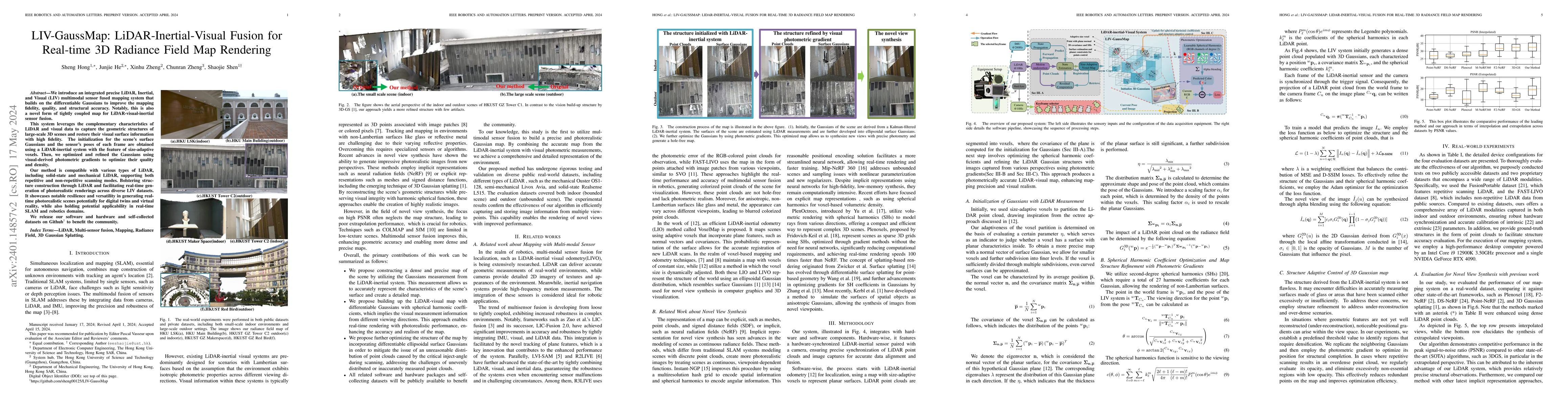
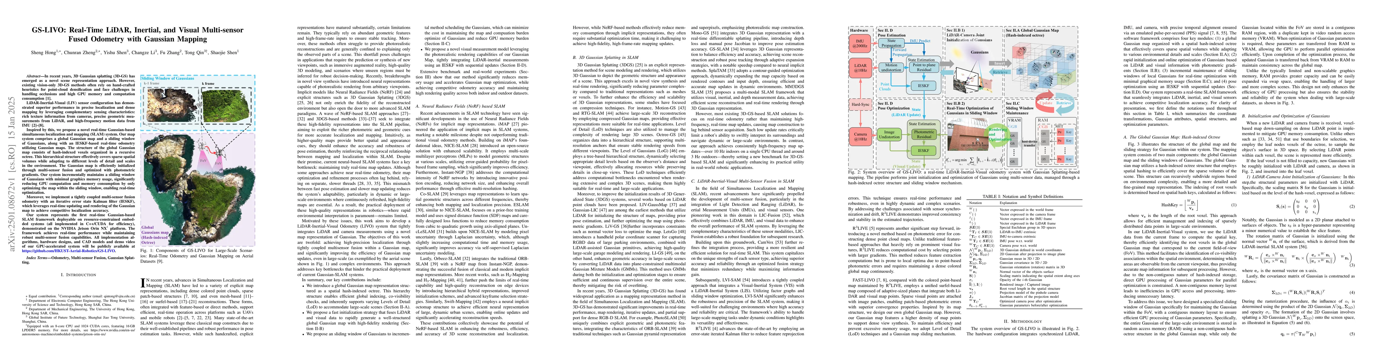
We introduce an integrated precise LiDAR, Inertial, and Visual (LIV) multimodal sensor fused mapping system that builds on the differentiable \pre{surface splatting }\now{Gaussians} to improve the m...
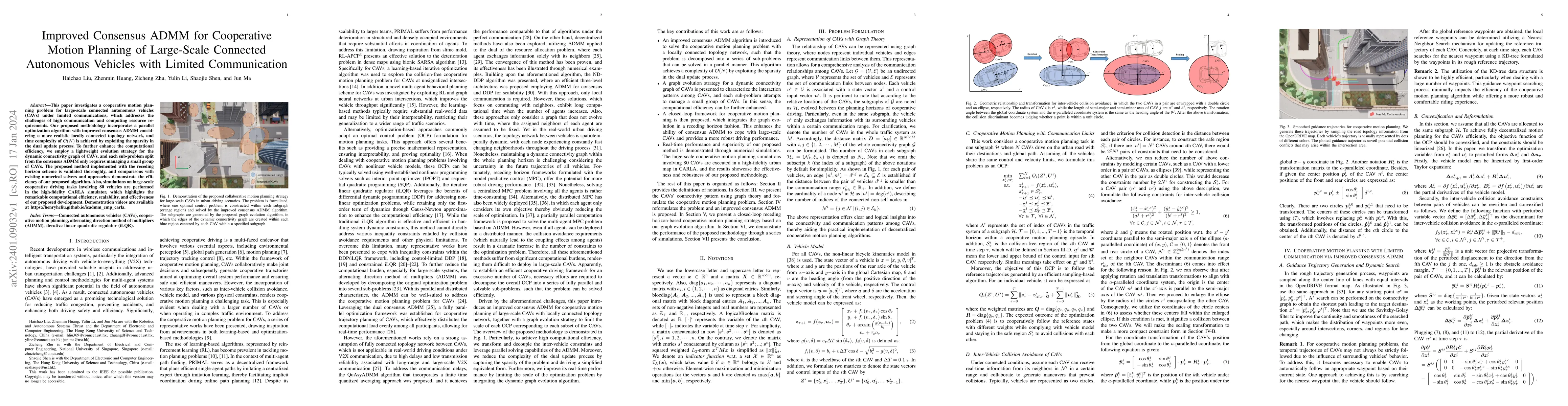
This paper investigates a cooperative motion planning problem for large-scale connected autonomous vehicles (CAVs) under limited communications, which addresses the challenges of high communication ...
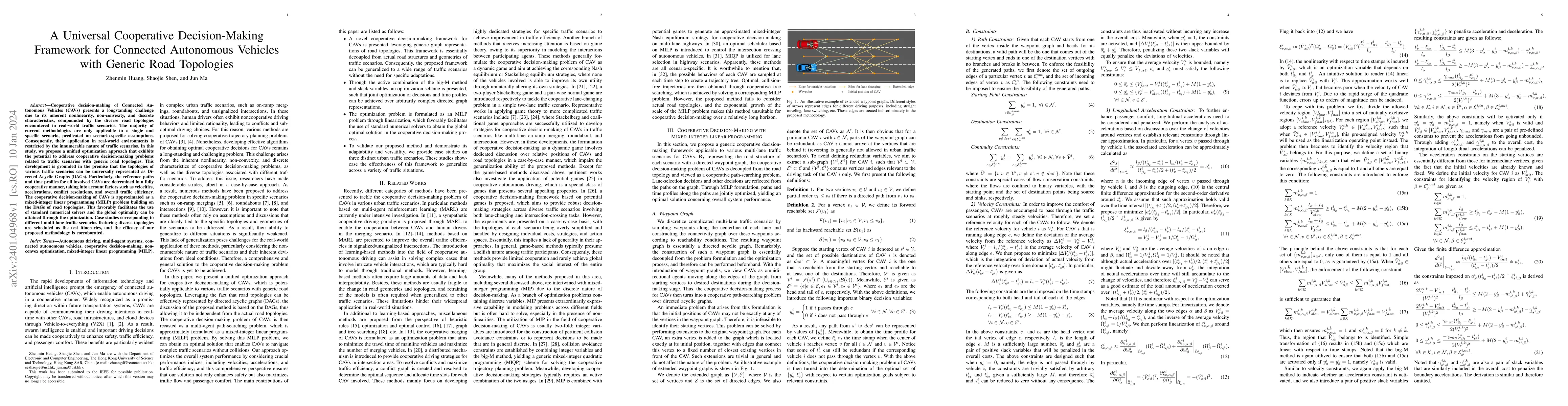
Cooperative decision-making of Connected Autonomous Vehicles (CAVs) presents a longstanding challenge due to its inherent nonlinearity, non-convexity, and discrete characteristics, compounded by the...
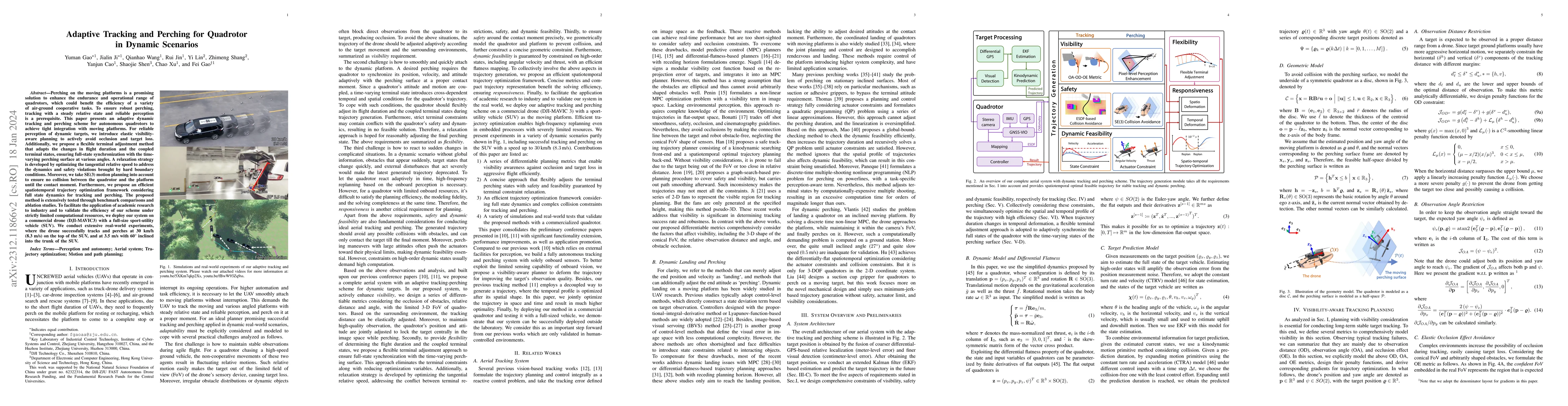
Perching on the moving platforms is a promising solution to enhance the endurance and operational range of quadrotors, which could benefit the efficiency of a variety of air-ground cooperative tasks...
Neuromorphic event-based cameras are bio-inspired visual sensors with asynchronous pixels and extremely high temporal resolution. Such favorable properties make them an excellent choice for solving ...
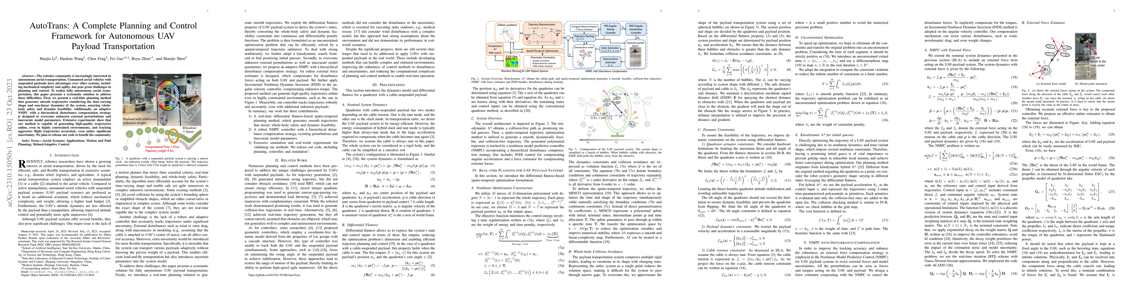
The robotics community is increasingly interested in autonomous aerial transportation. Unmanned aerial vehicles with suspended payloads have advantages over other systems, including mechanical simpl...
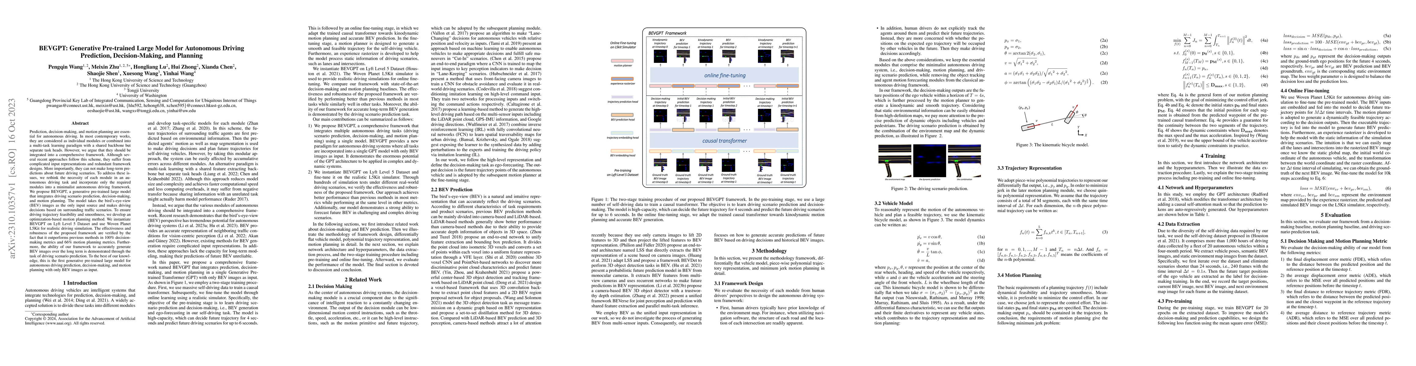
Prediction, decision-making, and motion planning are essential for autonomous driving. In most contemporary works, they are considered as individual modules or combined into a multi-task learning pa...
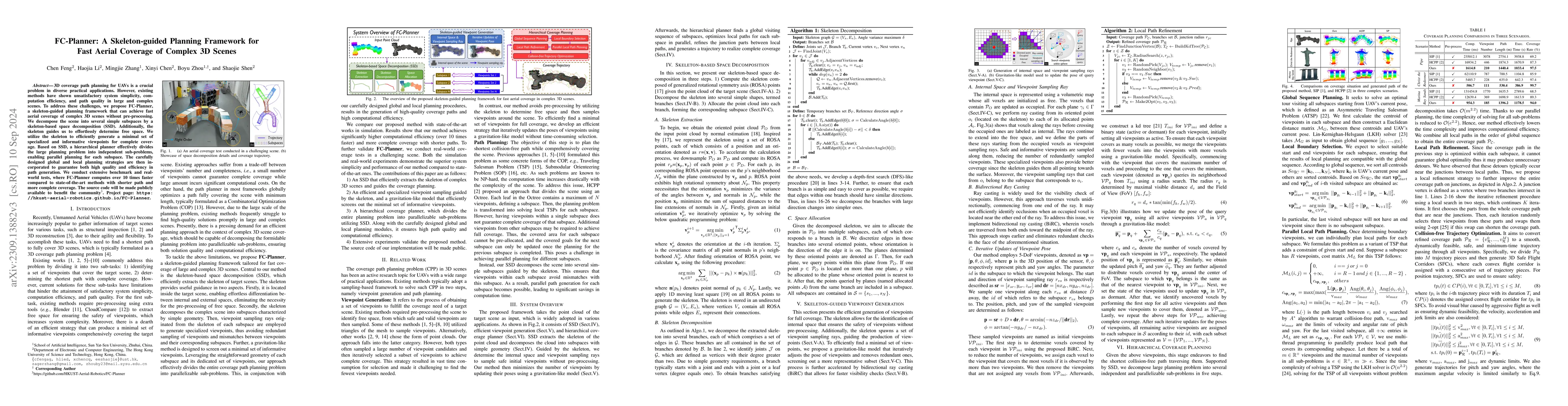
3D coverage path planning for UAVs is a crucial problem in diverse practical applications. However, existing methods have shown unsatisfactory system simplicity, computation efficiency, and path qua...
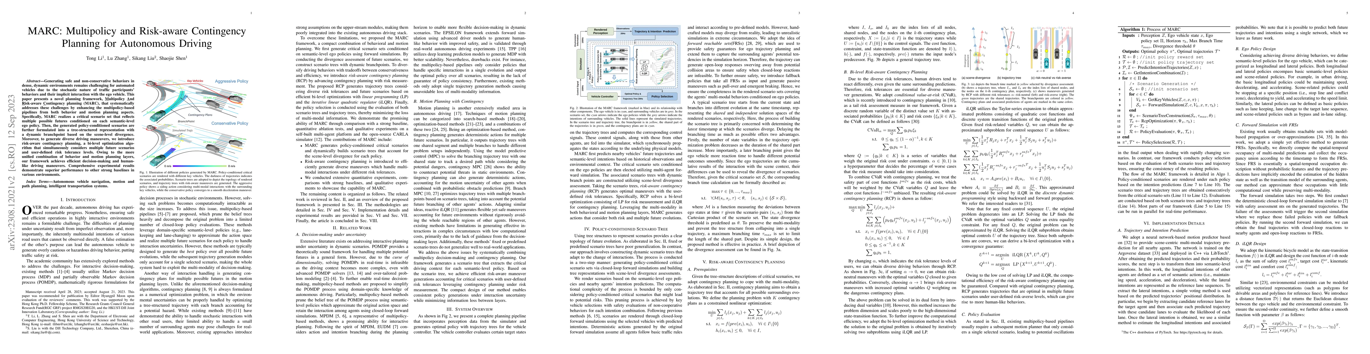
Generating safe and non-conservative behaviors in dense, dynamic environments remains challenging for automated vehicles due to the stochastic nature of traffic participants' behaviors and their imp...
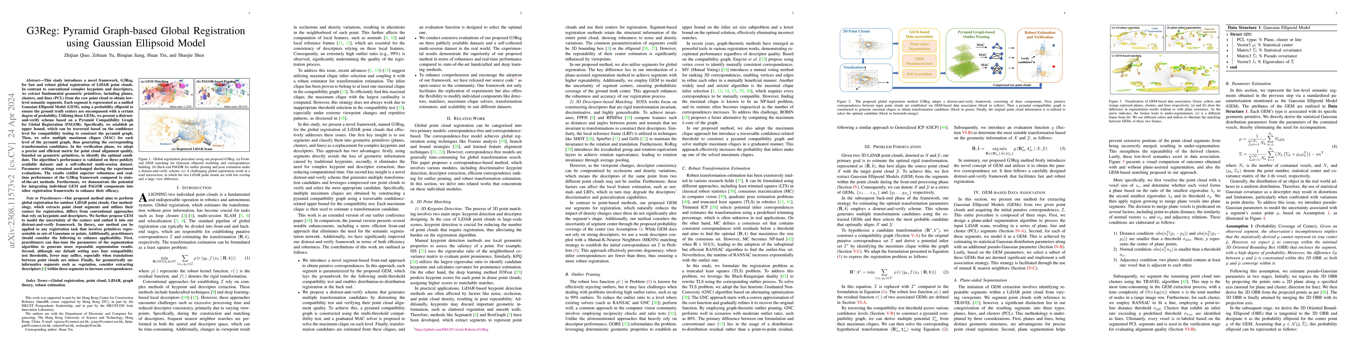
This study introduces a novel framework, G3Reg, for fast and robust global registration of LiDAR point clouds. In contrast to conventional complex keypoints and descriptors, we extract fundamental g...
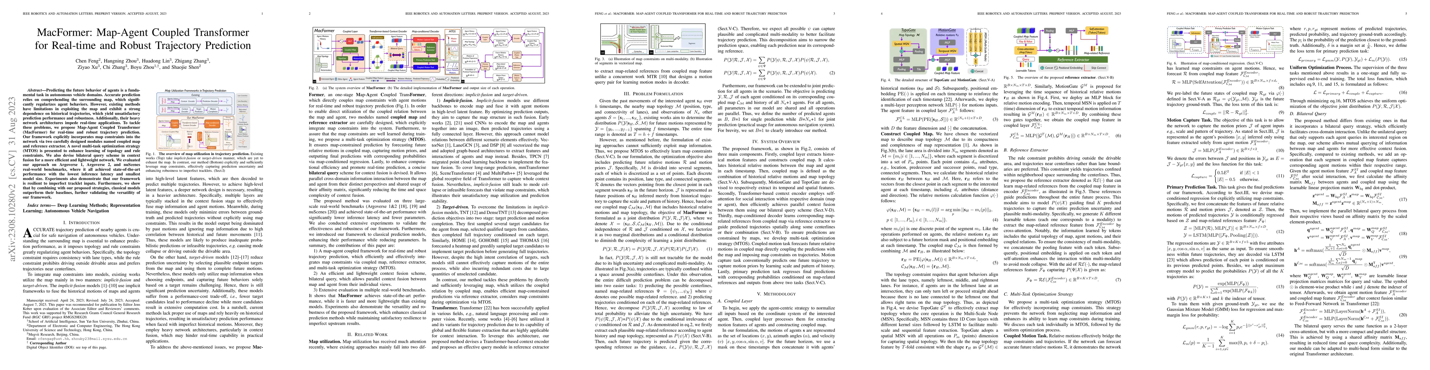
Predicting the future behavior of agents is a fundamental task in autonomous vehicle domains. Accurate prediction relies on comprehending the surrounding map, which significantly regularizes agent b...
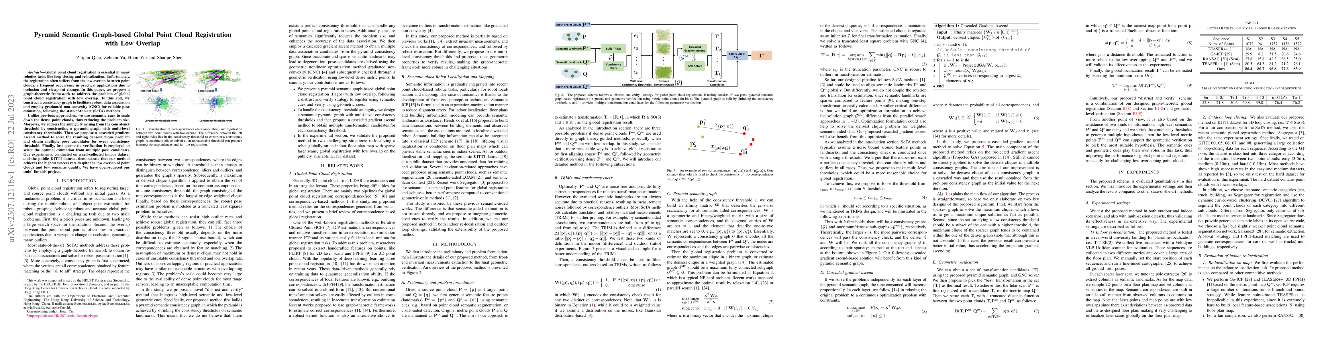
Global point cloud registration is essential in many robotics tasks like loop closing and relocalization. Unfortunately, the registration often suffers from the low overlap between point clouds, a f...
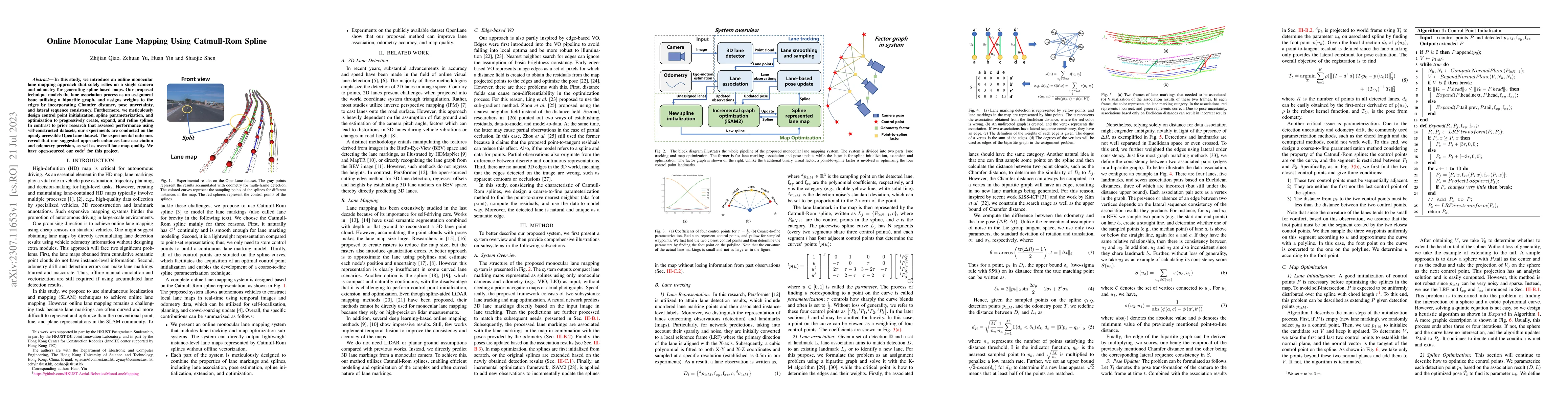
In this study, we introduce an online monocular lane mapping approach that solely relies on a single camera and odometry for generating spline-based maps. Our proposed technique models the lane asso...
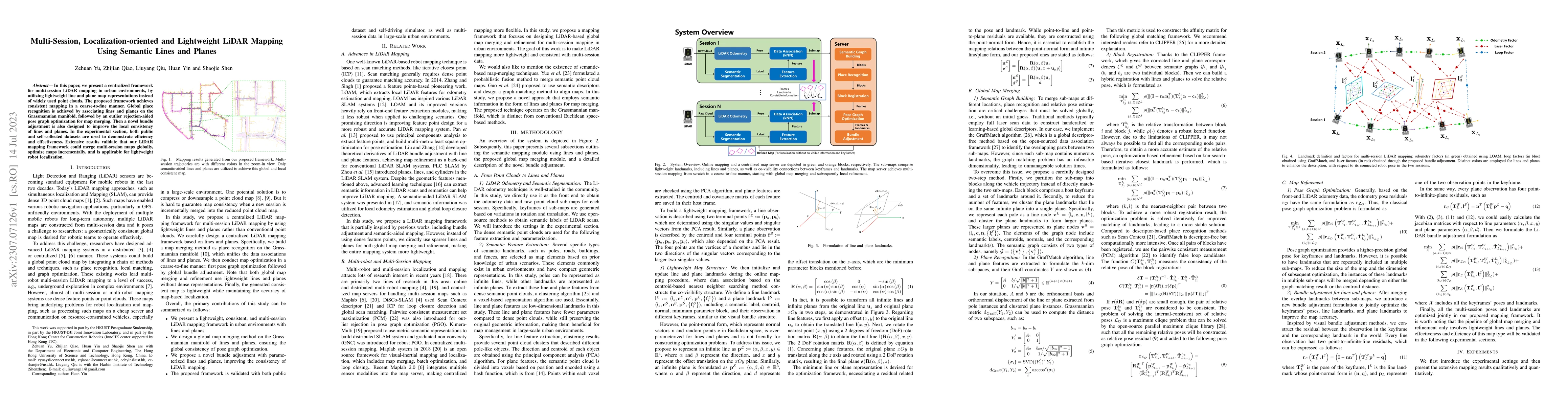
In this paper, we present a centralized framework for multi-session LiDAR mapping in urban environments, by utilizing lightweight line and plane map representations instead of widely used point clou...
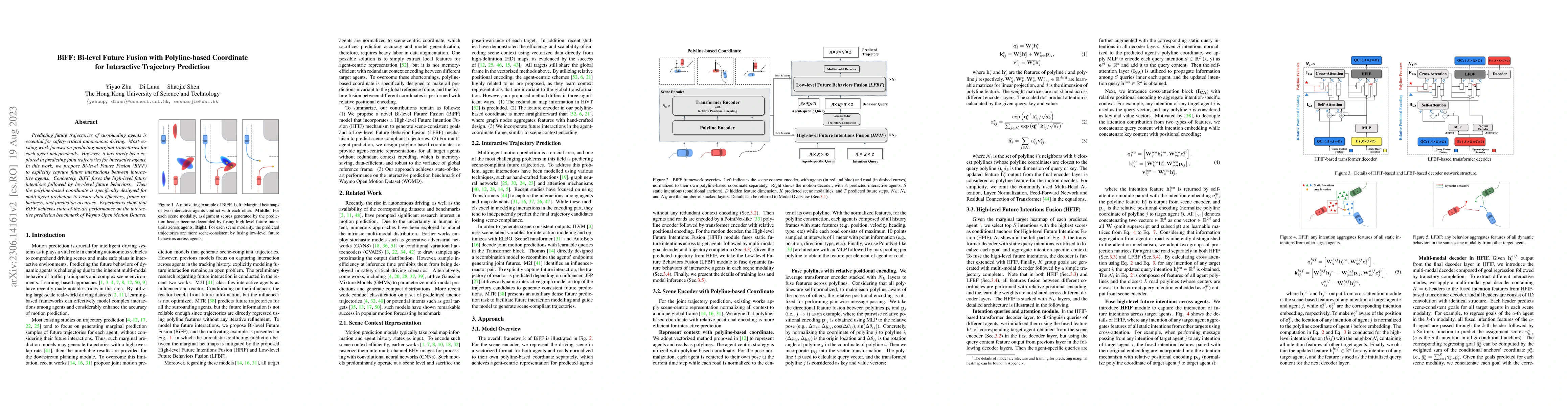
Predicting future trajectories of surrounding agents is essential for safety-critical autonomous driving. Most existing work focuses on predicting marginal trajectories for each agent independently....
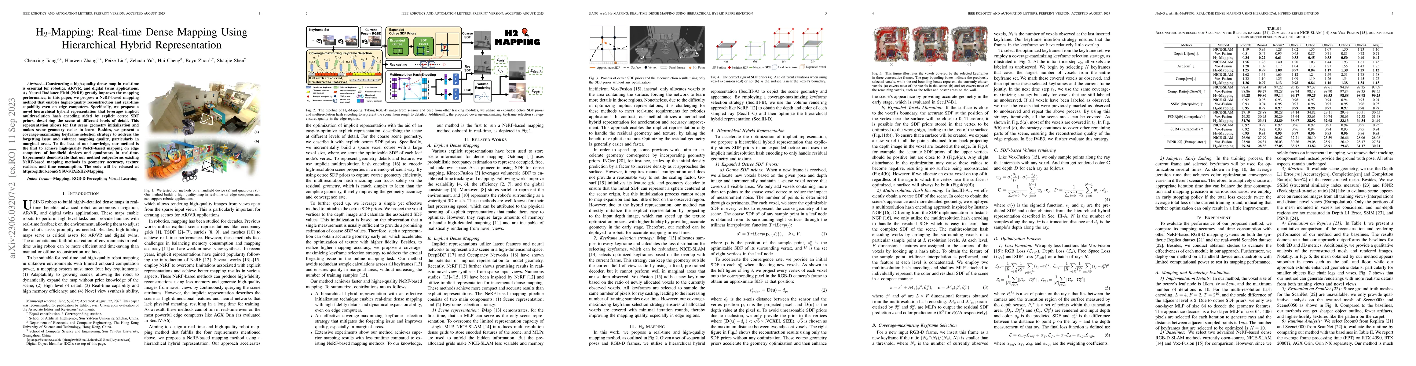
Constructing a high-quality dense map in real-time is essential for robotics, AR/VR, and digital twins applications. As Neural Radiance Field (NeRF) greatly improves the mapping performance, in this...
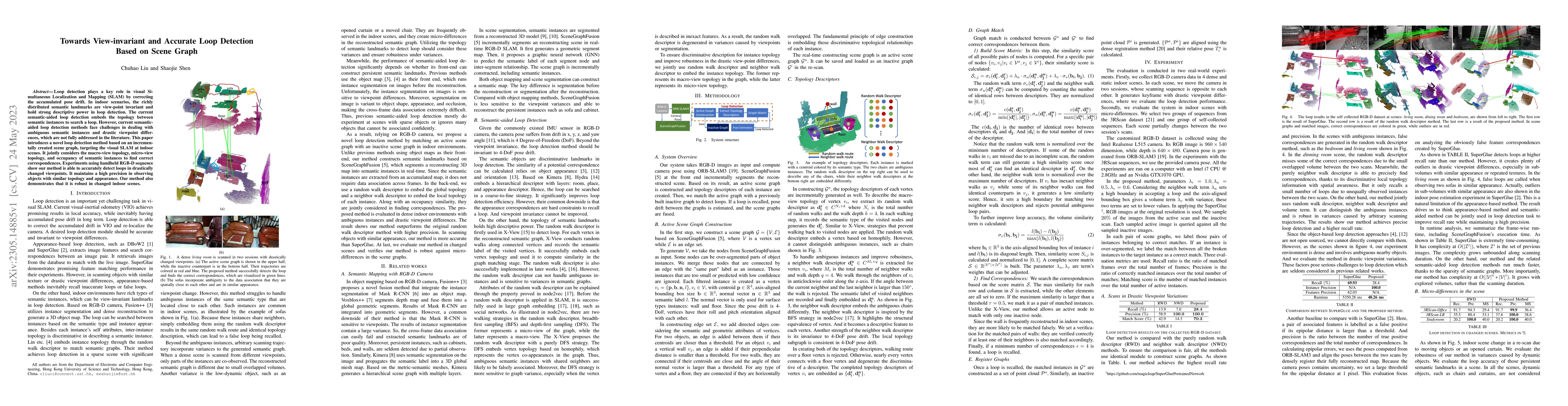
Loop detection plays a key role in visual Simultaneous Localization and Mapping (SLAM) by correcting the accumulated pose drift. In indoor scenarios, the richly distributed semantic landmarks are vi...
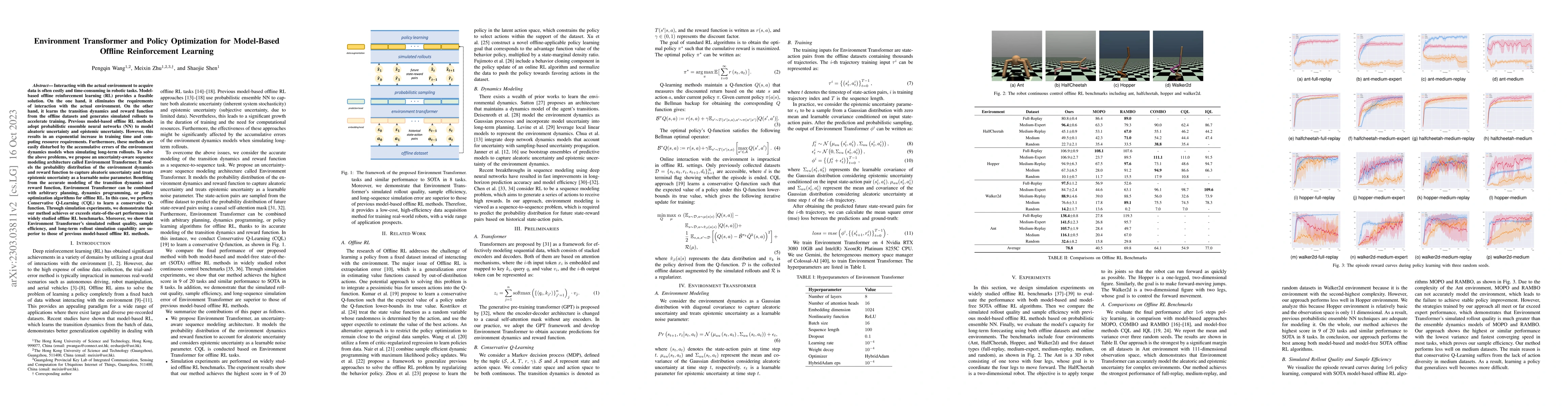
Interacting with the actual environment to acquire data is often costly and time-consuming in robotic tasks. Model-based offline reinforcement learning (RL) provides a feasible solution. On the one ...
The development of connected autonomous vehicles (CAVs) facilitates the enhancement of traffic efficiency in complicated scenarios. In unsignalized roundabout scenarios, difficulties remain unsolved...
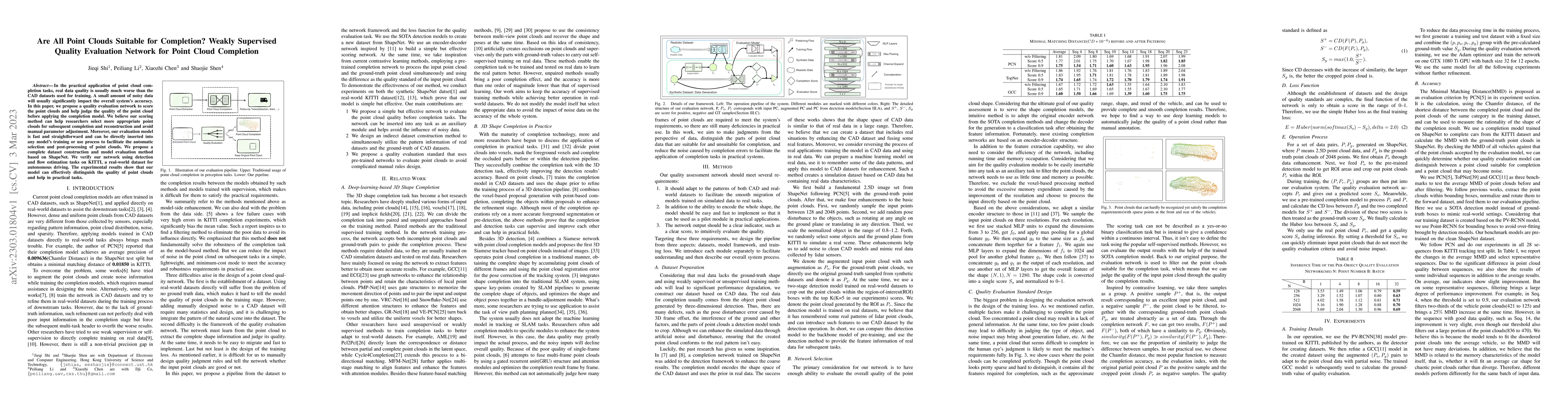
In the practical application of point cloud completion tasks, real data quality is usually much worse than the CAD datasets used for training. A small amount of noisy data will usually significantly...
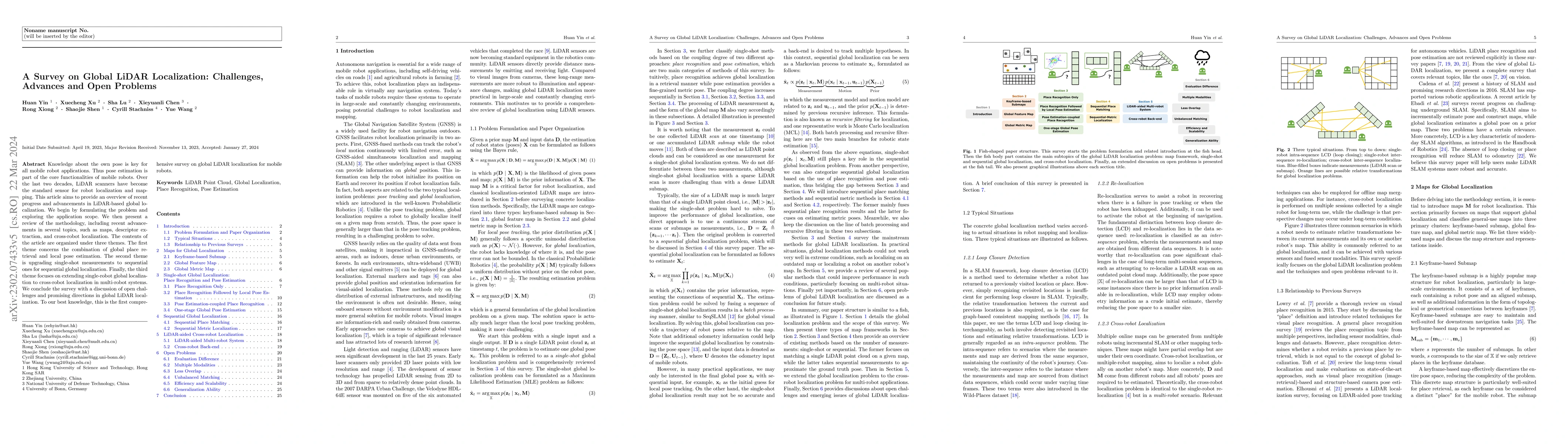
Knowledge about the own pose is key for all mobile robot applications. Thus pose estimation is part of the core functionalities of mobile robots. Over the last two decades, LiDAR scanners have becom...
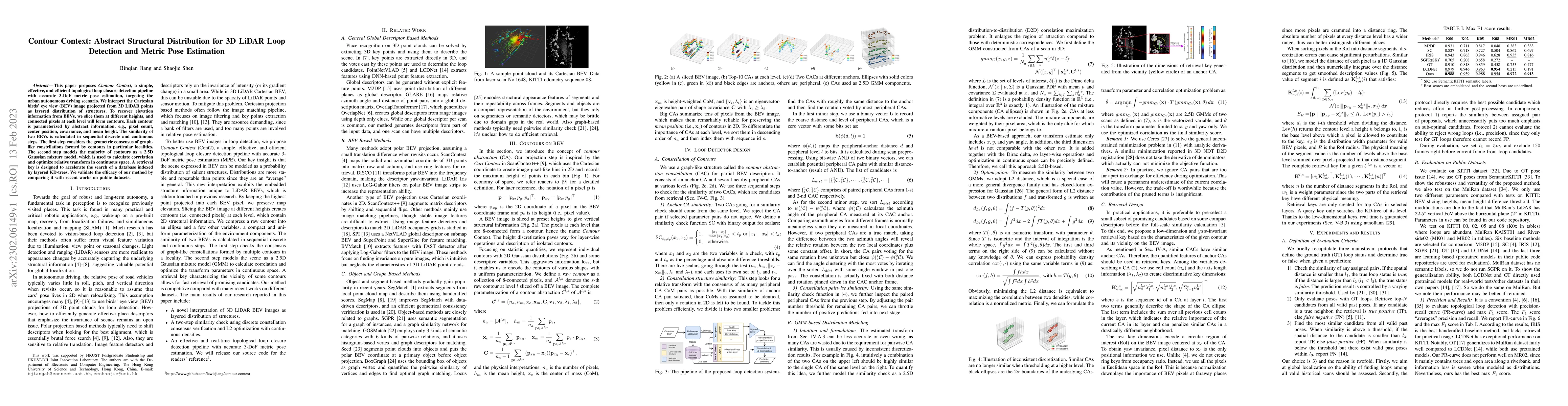
This paper proposes \textit{Contour Context}, a simple, effective, and efficient topological loop closure detection pipeline with accurate 3-DoF metric pose estimation, targeting the urban utonomous...
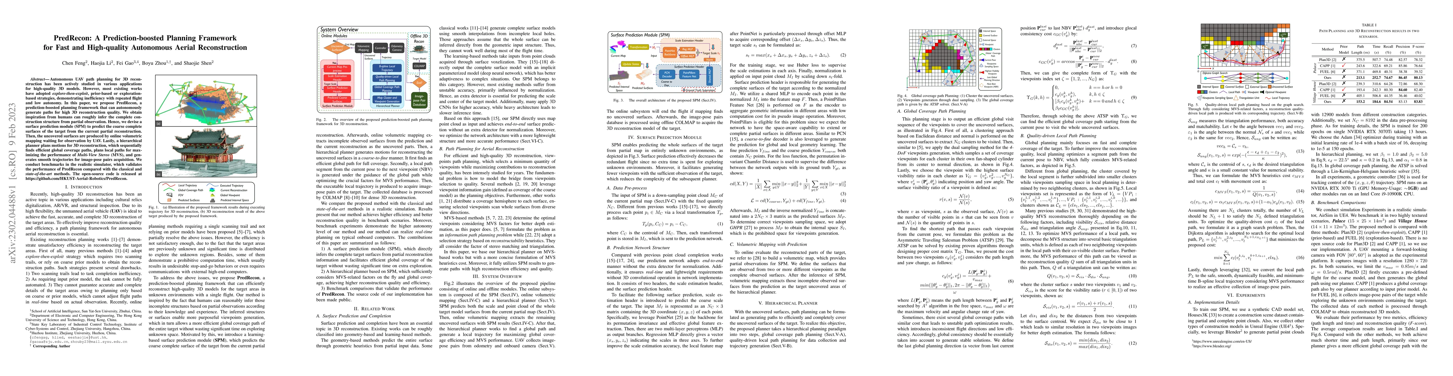
Autonomous UAV path planning for 3D reconstruction has been actively studied in various applications for high-quality 3D models. However, most existing works have adopted explore-then-exploit, prior...
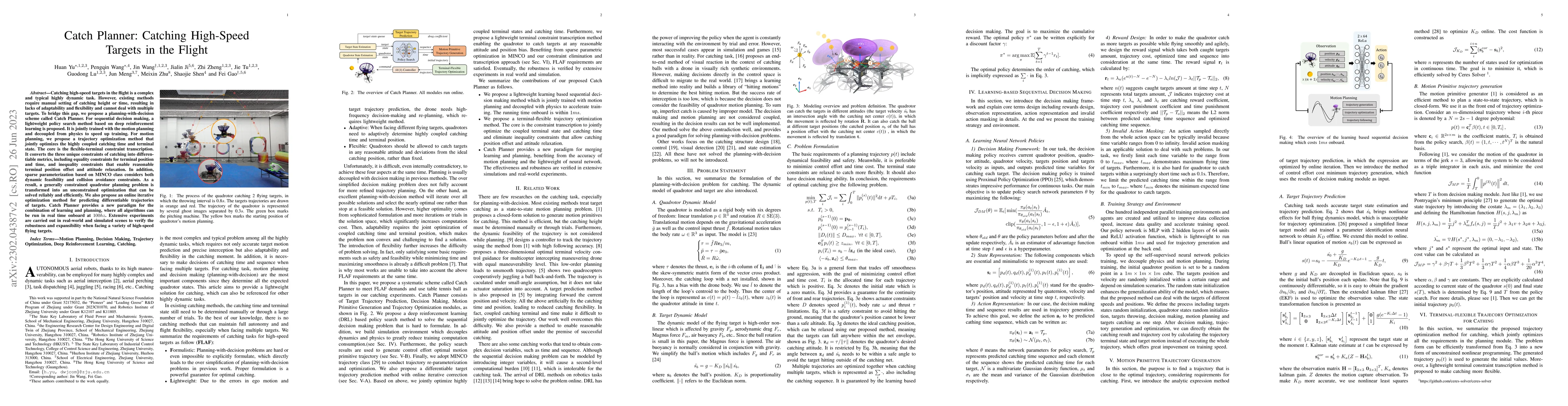
Catching high-speed targets in the flight is a complex and typical highly dynamic task. In this paper, we propose Catch Planner, a planning-with-decision scheme for catching. For sequential decision...
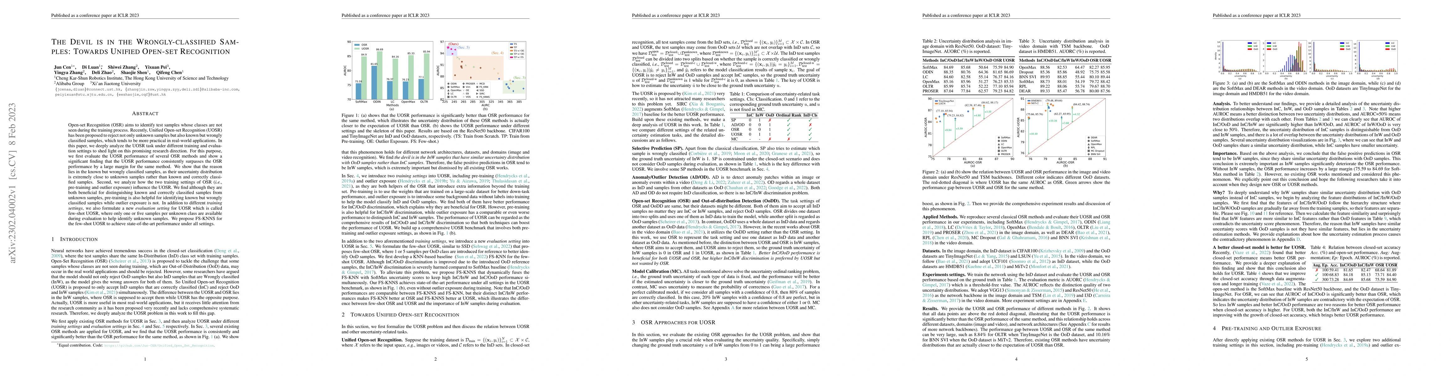
Open-set Recognition (OSR) aims to identify test samples whose classes are not seen during the training process. Recently, Unified Open-set Recognition (UOSR) has been proposed to reject not only un...
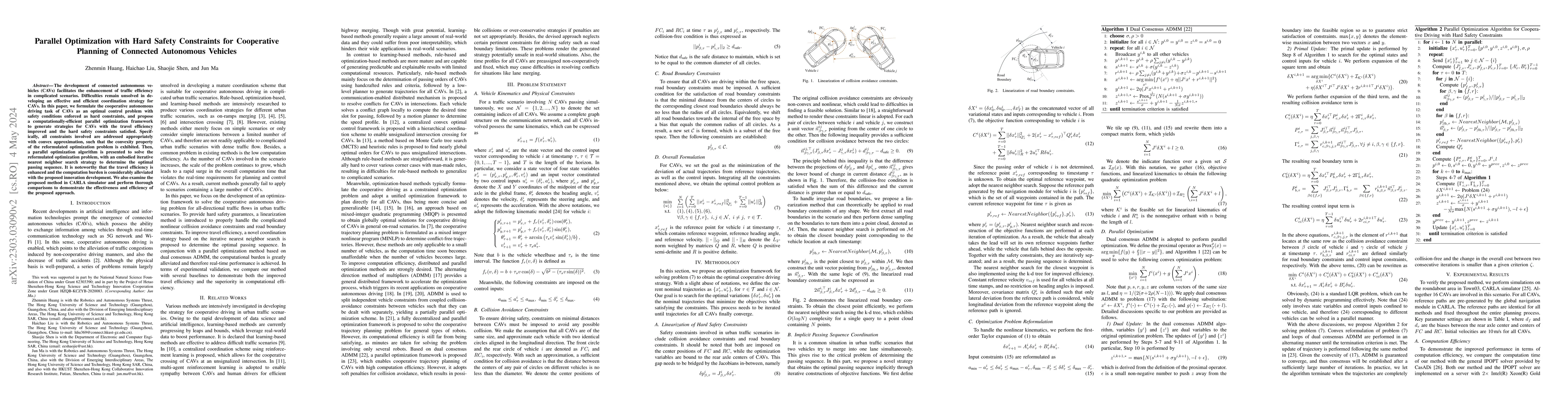
Developments in cooperative trajectory planning of connected autonomous vehicles (CAVs) have gathered considerable momentum and research attention. Generally, such problems present strong non-linear...
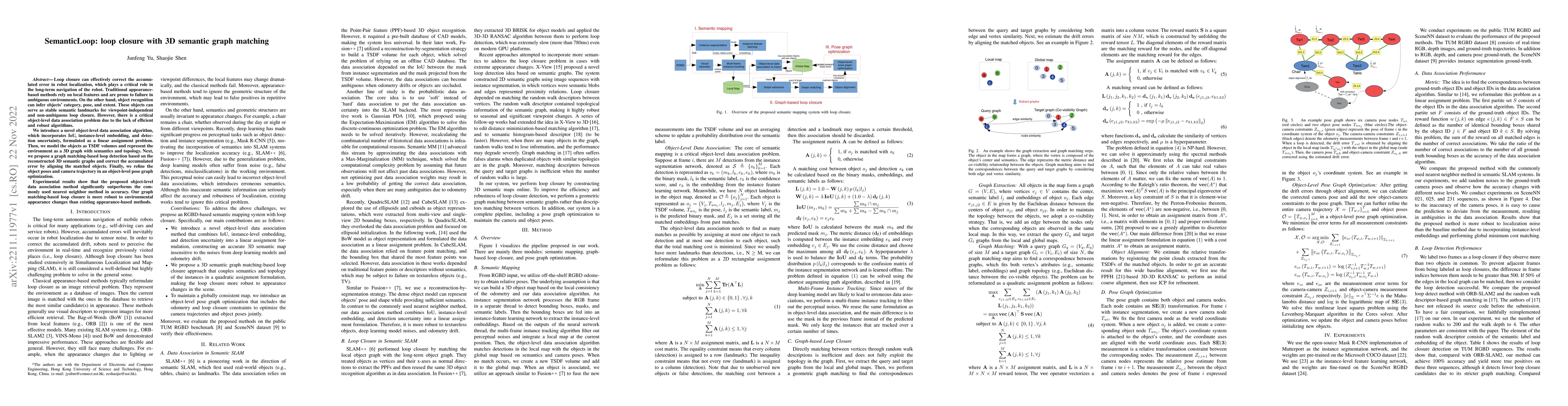
Loop closure can effectively correct the accumulated error in robot localization, which plays a critical role in the long-term navigation of the robot. Traditional appearance-based methods rely on l...
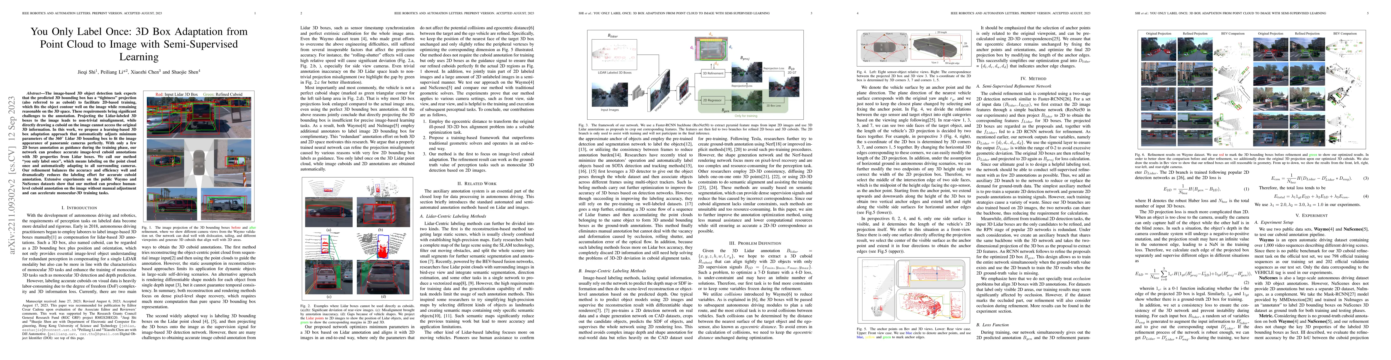
The image-based 3D object detection task expects that the predicted 3D bounding box has a ``tightness'' projection (also referred to as cuboid), which fits the object contour well on the image while...
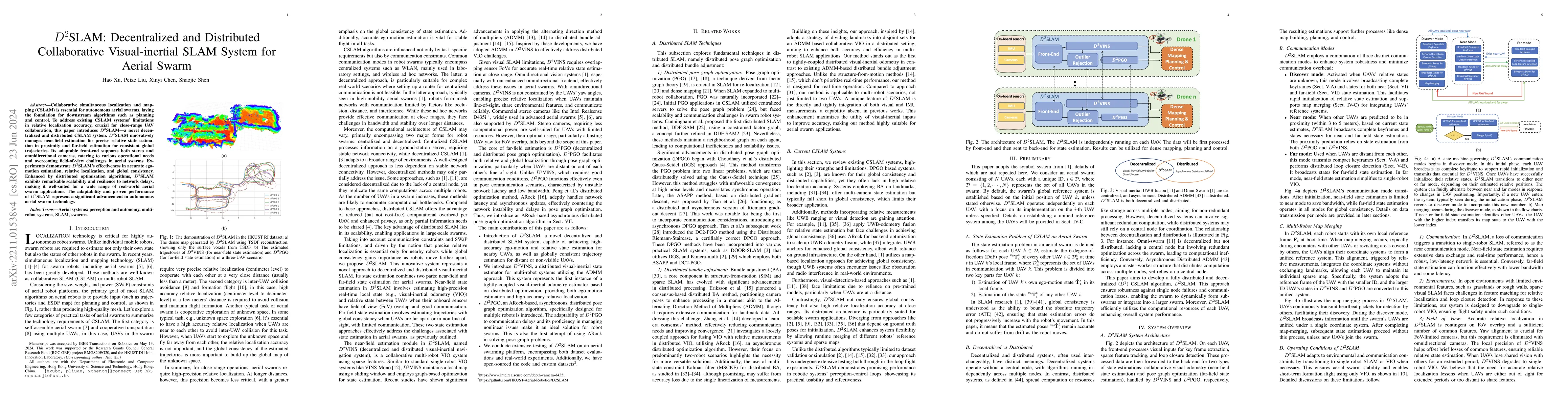
Collaborative simultaneous localization and mapping (CSLAM) is essential for autonomous aerial swarms, laying the foundation for downstream algorithms such as planning and control. To address existi...
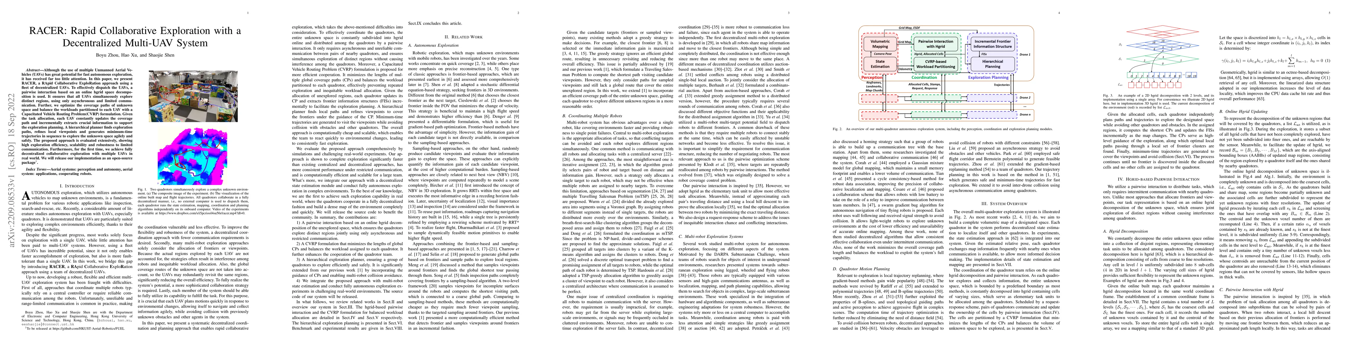
Although the use of multiple Unmanned Aerial Vehicles (UAVs) has great potential for fast autonomous exploration, it has received far too little attention. In this paper, we present RACER, a RApid C...
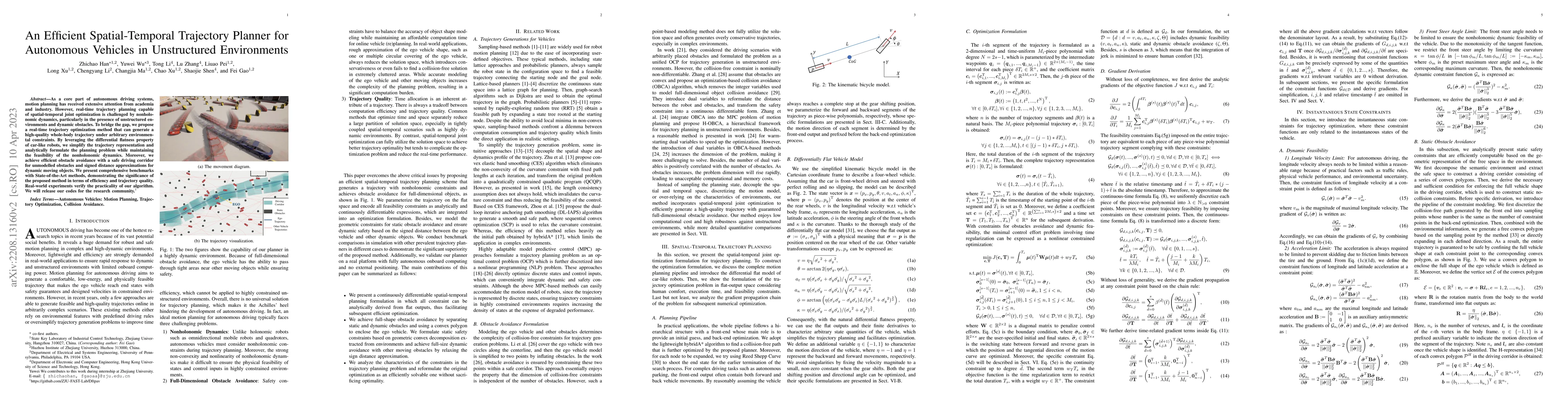
As a core part of autonomous driving systems, motion planning has received extensive attention from academia and industry. However, real-time trajectory planning capable of spatial-temporal joint op...
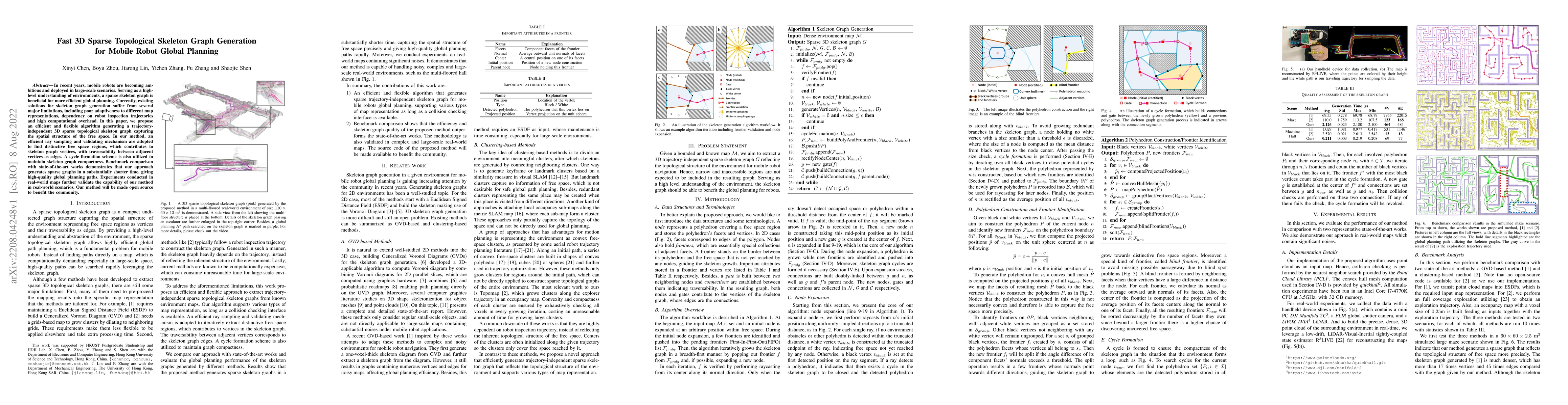
In recent years, mobile robots are becoming ambitious and deployed in large-scale scenarios. Serving as a high-level understanding of environments, a sparse skeleton graph is beneficial for more eff...
Despite recent progress of robotic exploration, most methods assume that drift-free localization is available, which is problematic in reality and causes severe distortion of the reconstructed map. ...
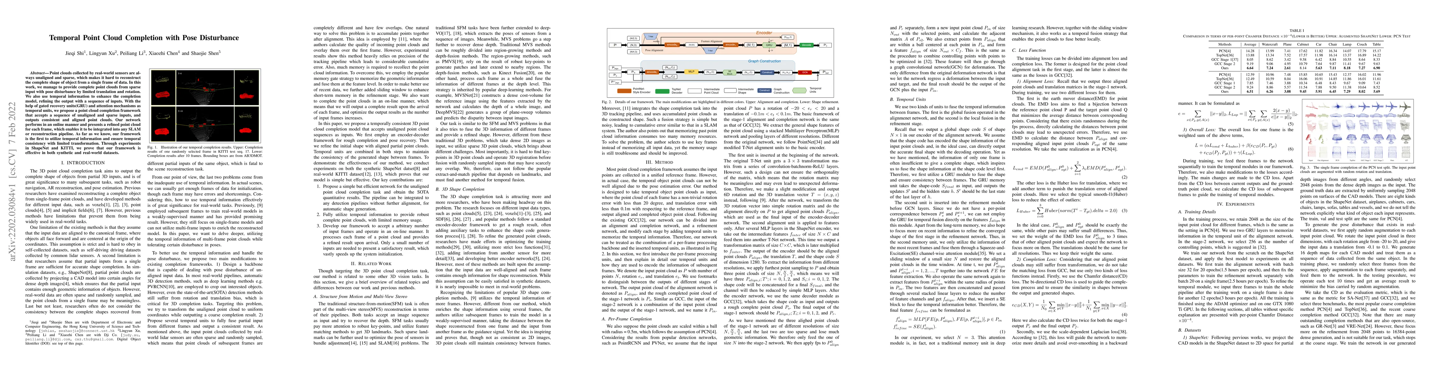
Point clouds collected by real-world sensors are always unaligned and sparse, which makes it hard to reconstruct the complete shape of object from a single frame of data. In this work, we manage to ...
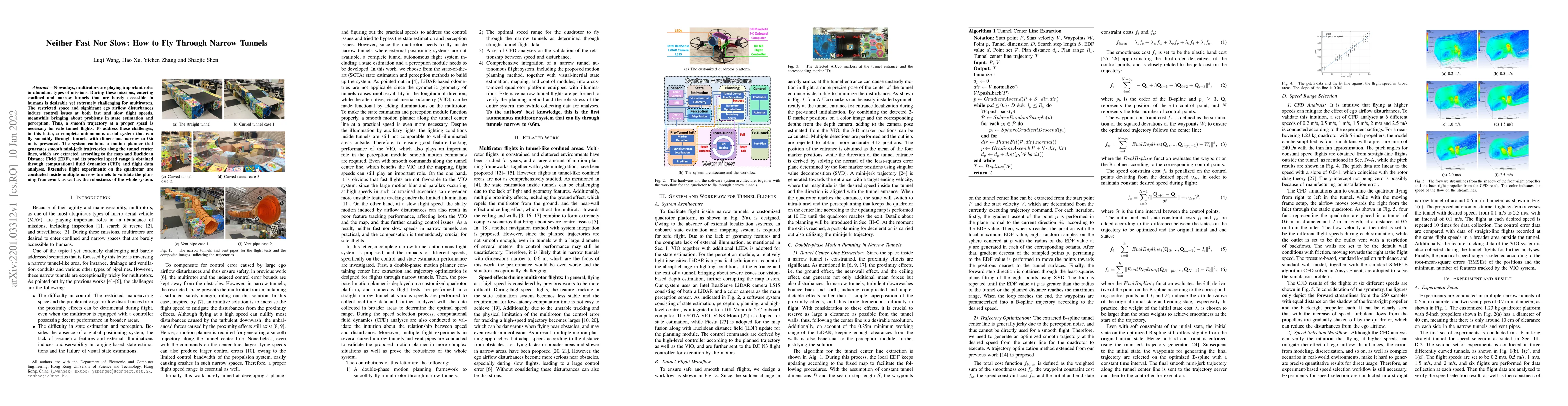
Nowadays, multirotors are playing important roles in abundant types of missions. During these missions, entering confined and narrow tunnels that are barely accessible to humans is desirable yet ext...

For a long time, the point cloud completion task has been regarded as a pure generation task. After obtaining the global shape code through the encoder, a complete point cloud is generated using the...
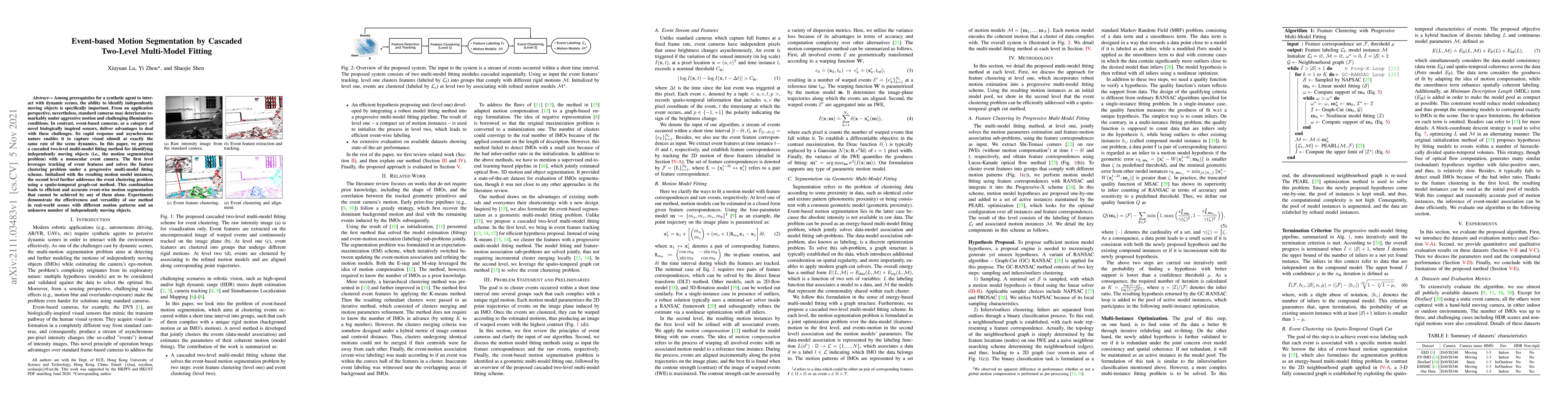
Among prerequisites for a synthetic agent to interact with dynamic scenes, the ability to identify independently moving objects is specifically important. From an application perspective, neverthele...
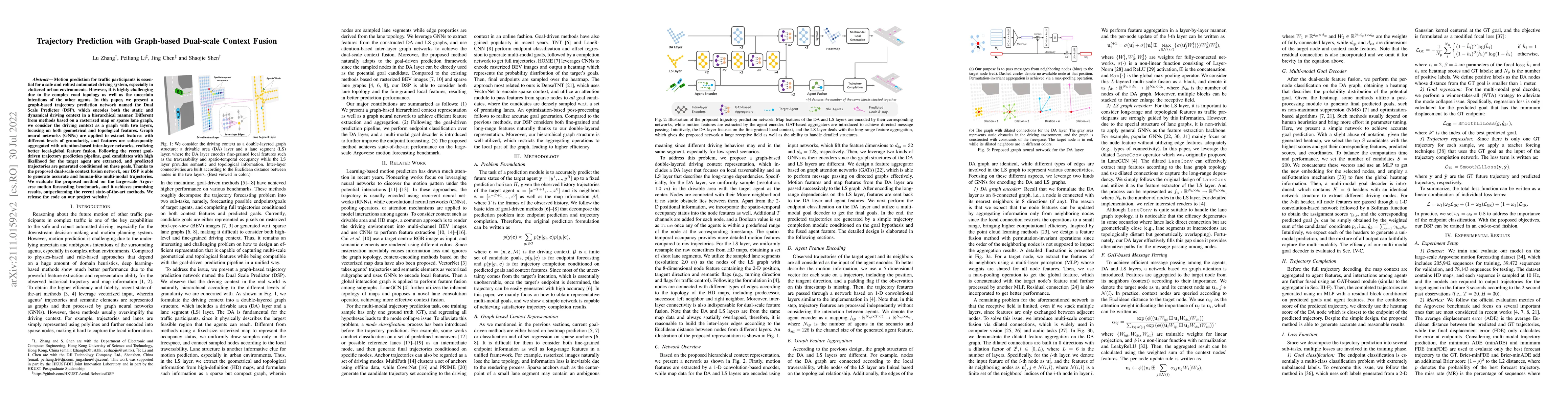
Motion prediction for traffic participants is essential for a safe and robust automated driving system, especially in cluttered urban environments. However, it is highly challenging due to the compl...
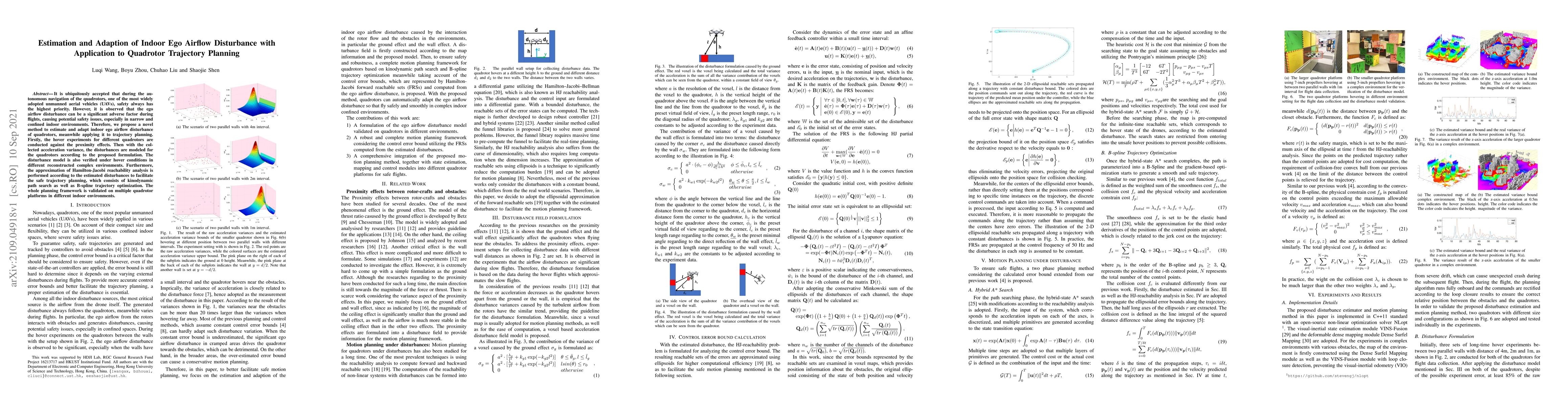
It is ubiquitously accepted that during the autonomous navigation of the quadrotors, one of the most widely adopted unmanned aerial vehicles (UAVs), safety always has the highest priority. However, ...
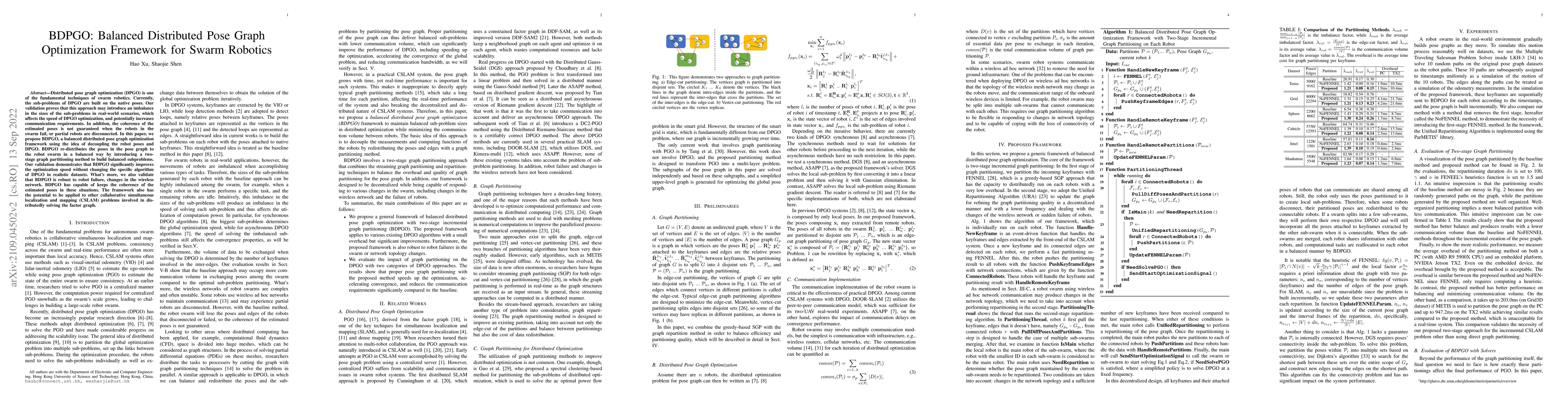
Distributed pose graph optimization (DPGO) is one of the fundamental techniques of swarm robotics. Currently, the sub-problems of DPGO are built on the native poses. Our validation proves that this ...
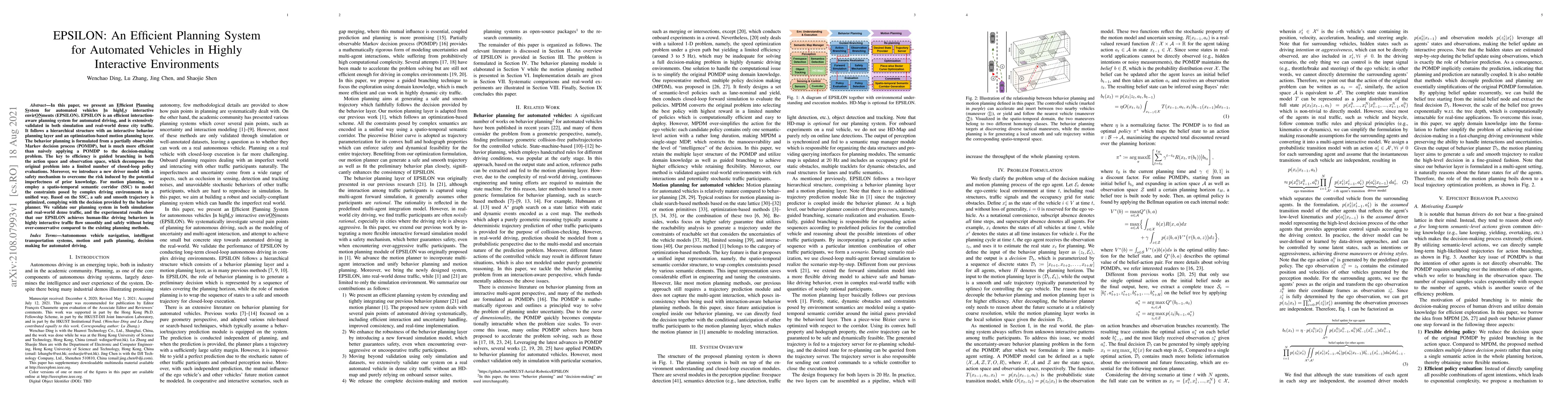
In this paper, we present an Efficient Planning System for automated vehicles In highLy interactive envirONments (EPSILON). EPSILON is an efficient interaction-aware planning system for automated dr...
Tail-sitter vertical takeoff and landing (VTOL) unmanned aerial vehicles (UAVs) have the capability of hovering and performing efficient level flight with compact mechanical structures. We present a...
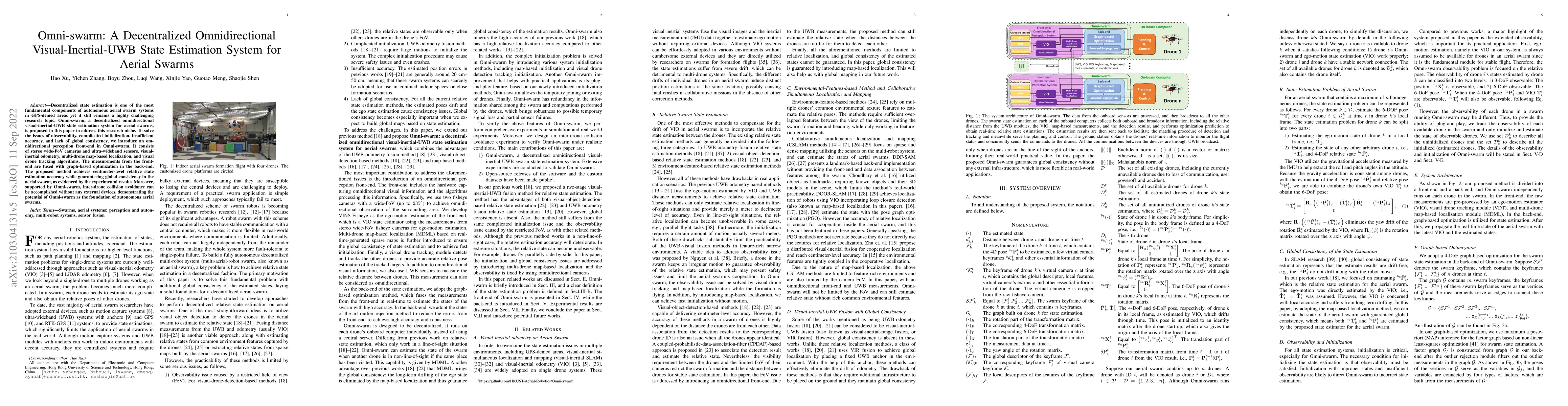
Decentralized state estimation is one of the most fundamental components of autonomous aerial swarm systems in GPS-denied areas yet it still remains a highly challenging research topic. Omni-swarm, ...
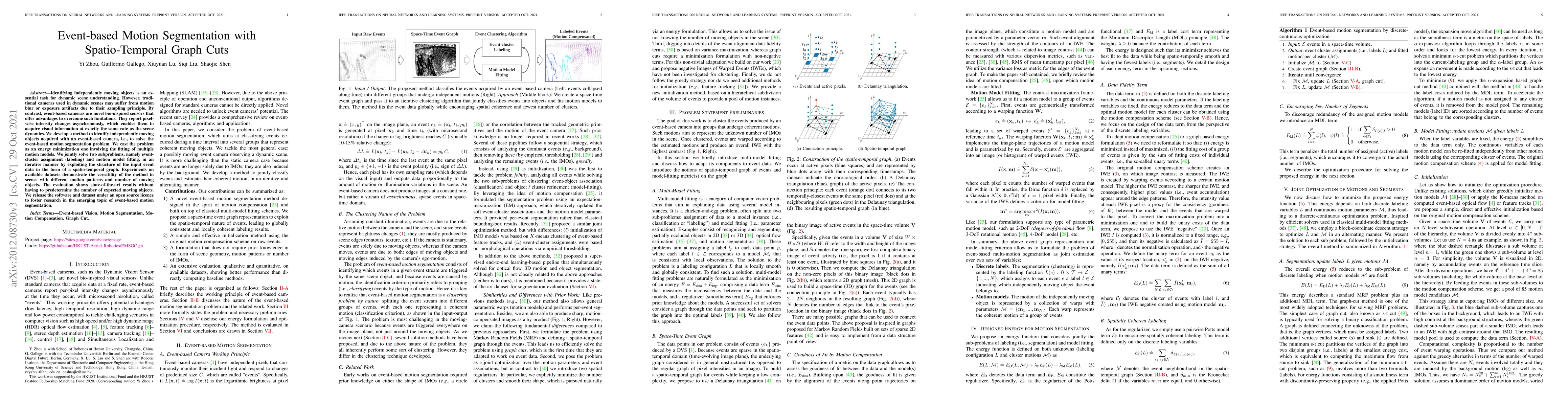
Identifying independently moving objects is an essential task for dynamic scene understanding. However, traditional cameras used in dynamic scenes may suffer from motion blur or exposure artifacts d...
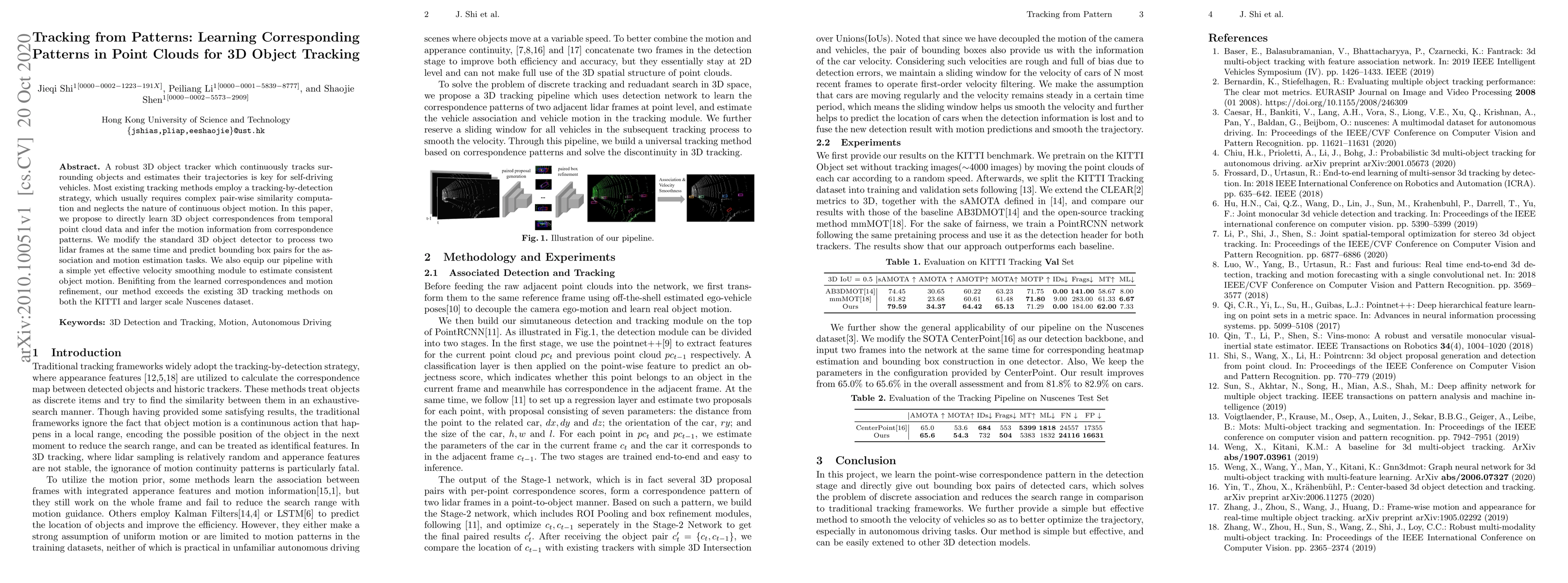
A robust 3D object tracker which continuously tracks surrounding objects and estimates their trajectories is key for self-driving vehicles. Most existing tracking methods employ a tracking-by-detect...
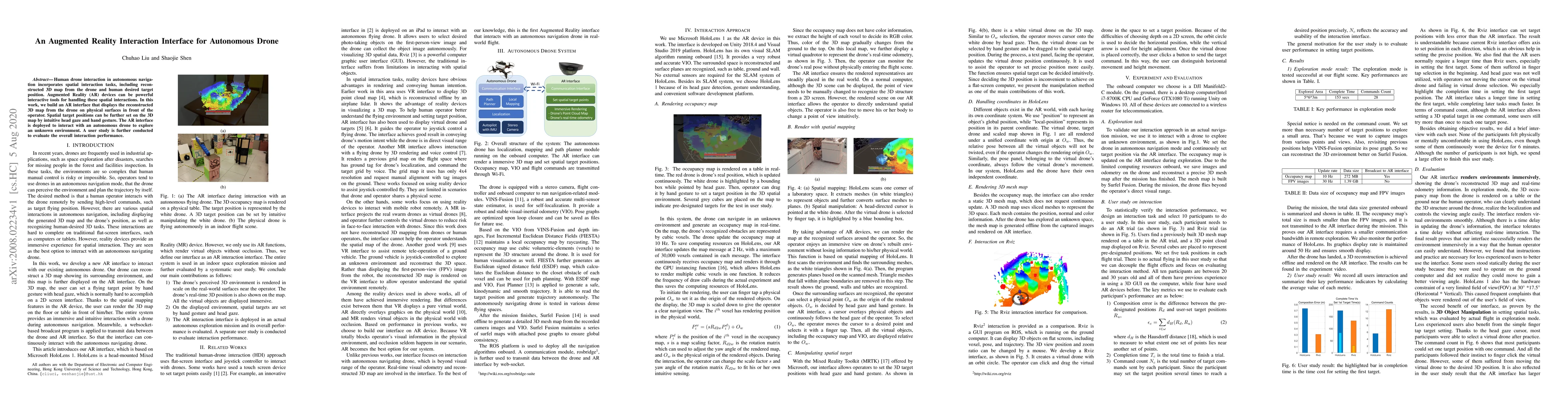
Human drone interaction in autonomous navigation incorporates spatial interaction tasks, including reconstructed 3D map from the drone and human desired target position. Augmented Reality (AR) devic...
Event-based cameras are bio-inspired vision sensors whose pixels work independently from each other and respond asynchronously to brightness changes, with microsecond resolution. Their advantages ma...
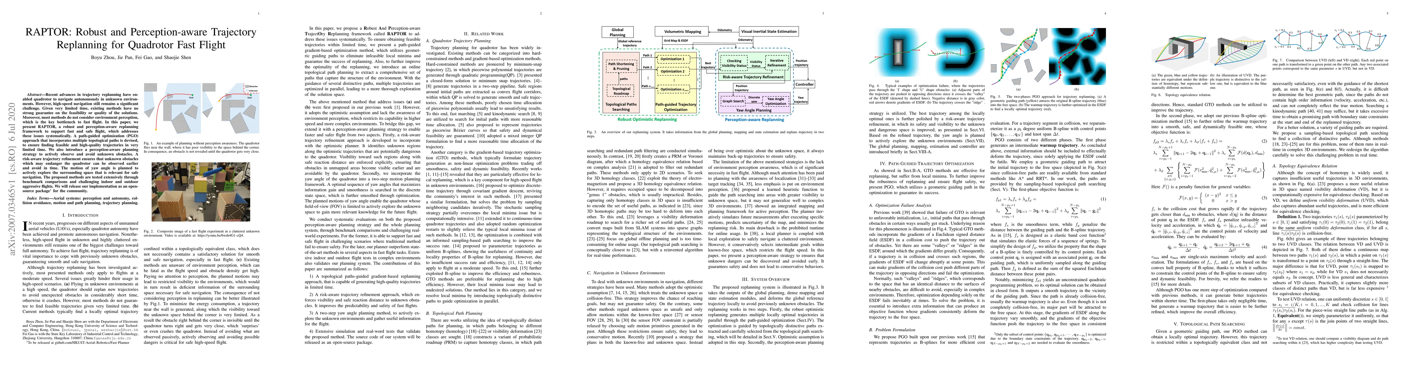
Recent advances in trajectory replanning have enabled quadrotor to navigate autonomously in unknown environments. However, high-speed navigation still remains a significant challenge. Given very lim...
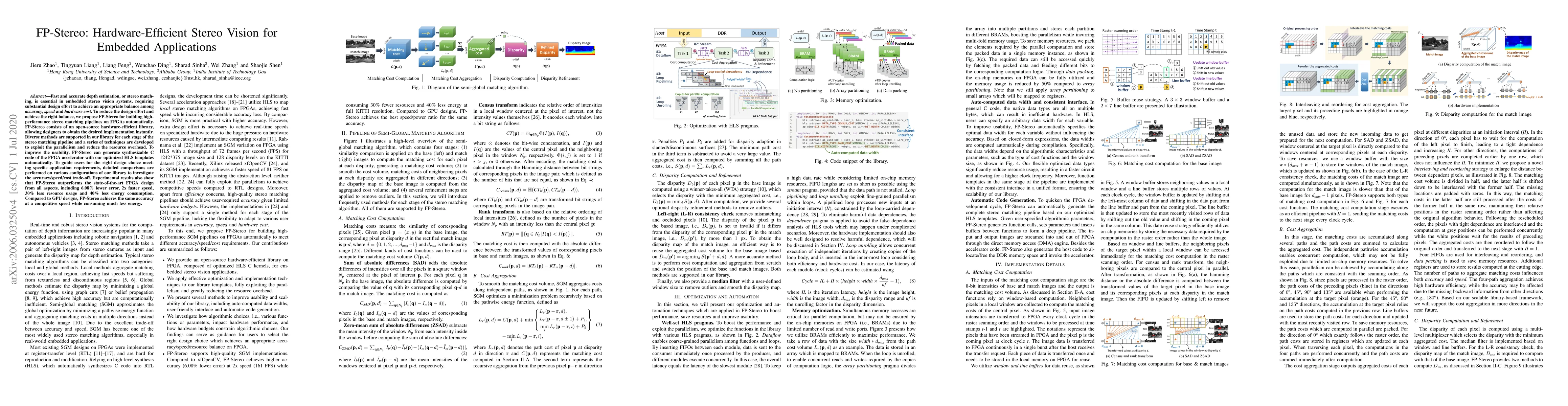
Fast and accurate depth estimation, or stereo matching, is essential in embedded stereo vision systems, requiring substantial design effort to achieve an appropriate balance among accuracy, speed an...
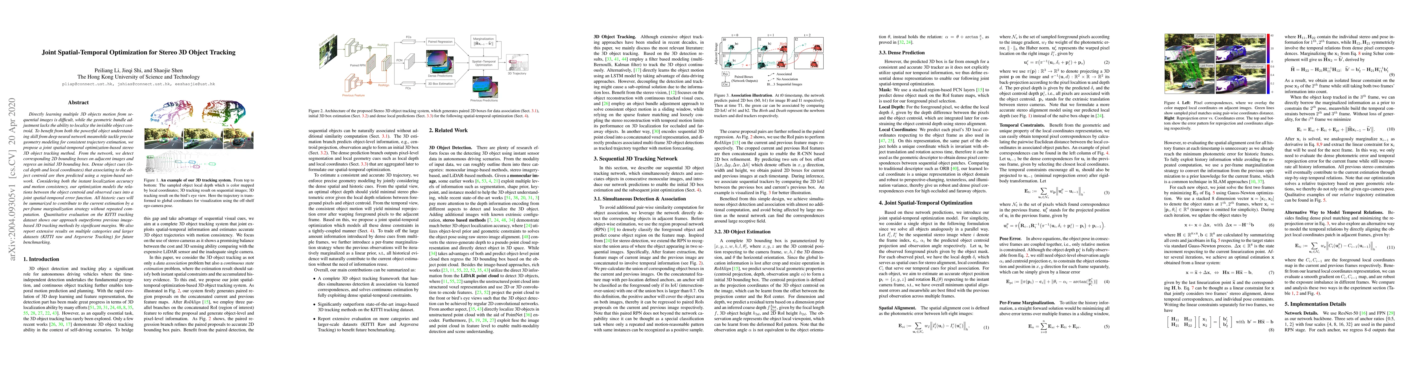
Directly learning multiple 3D objects motion from sequential images is difficult, while the geometric bundle adjustment lacks the ability to localize the invisible object centroid. To benefit from b...
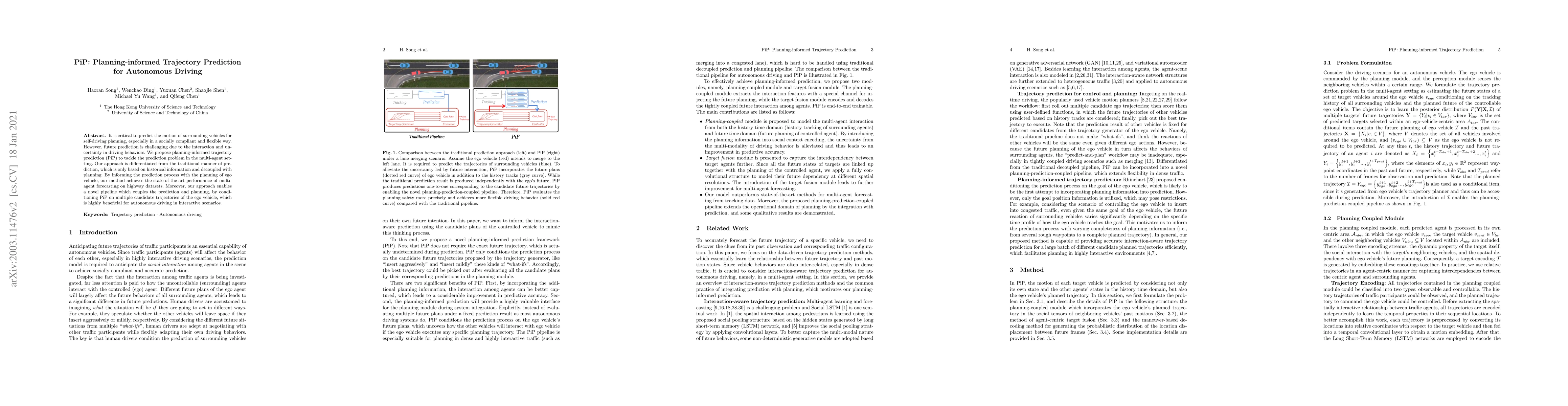
It is critical to predict the motion of surrounding vehicles for self-driving planning, especially in a socially compliant and flexible way. However, future prediction is challenging due to the inte...
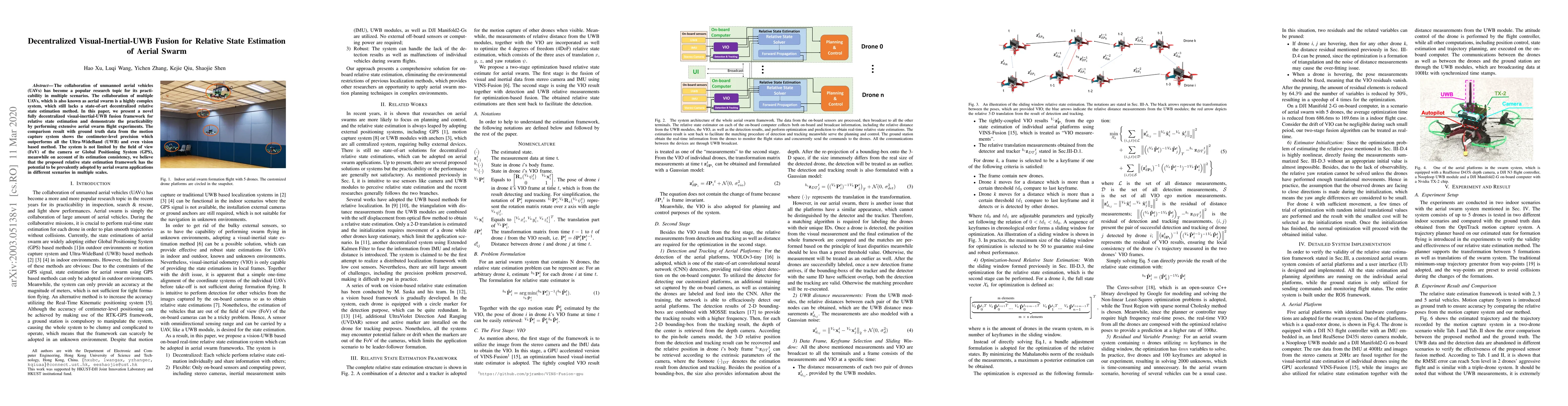
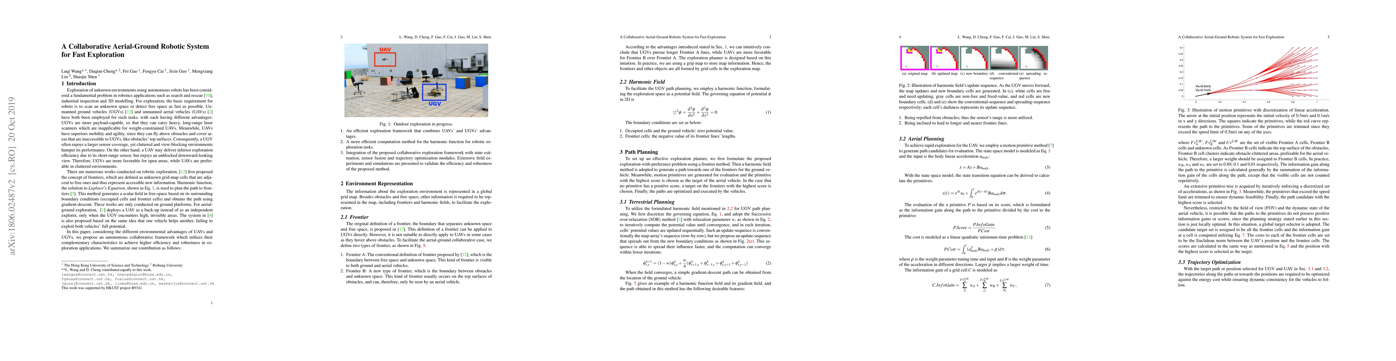
The collaboration of unmanned aerial vehicles (UAVs) has become a popular research topic for its practicability in multiple scenarios. The collaboration of multiple UAVs, which is also known as aeri...
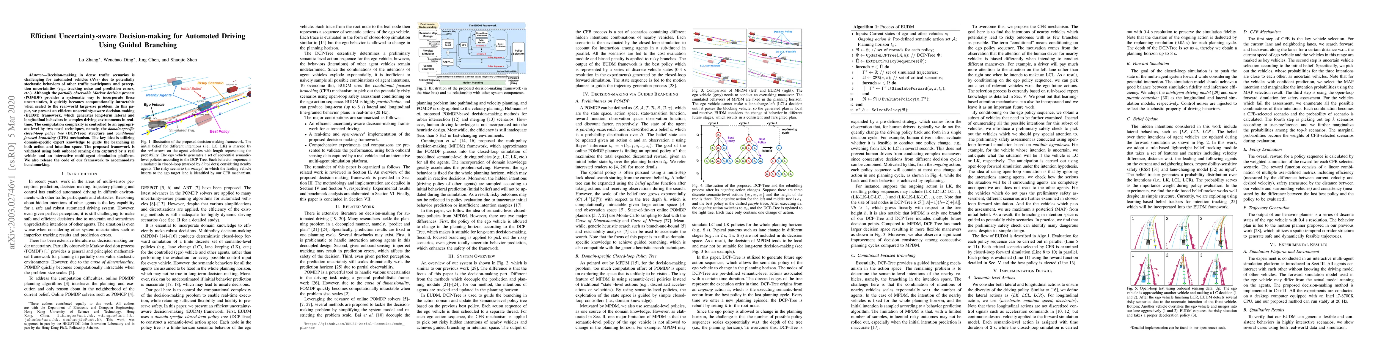
Decision-making in dense traffic scenarios is challenging for automated vehicles (AVs) due to potentially stochastic behaviors of other traffic participants and perception uncertainties (e.g., track...
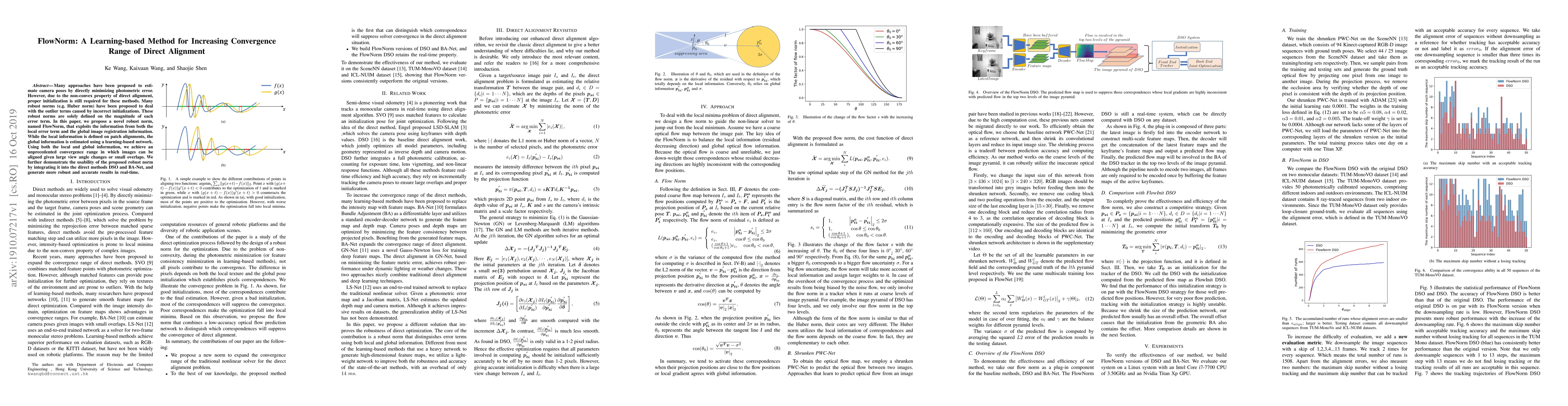
Many approaches have been proposed to estimate camera poses by directly minimizing photometric error. However, due to the non-convex property of direct alignment, proper initialization is still requ...
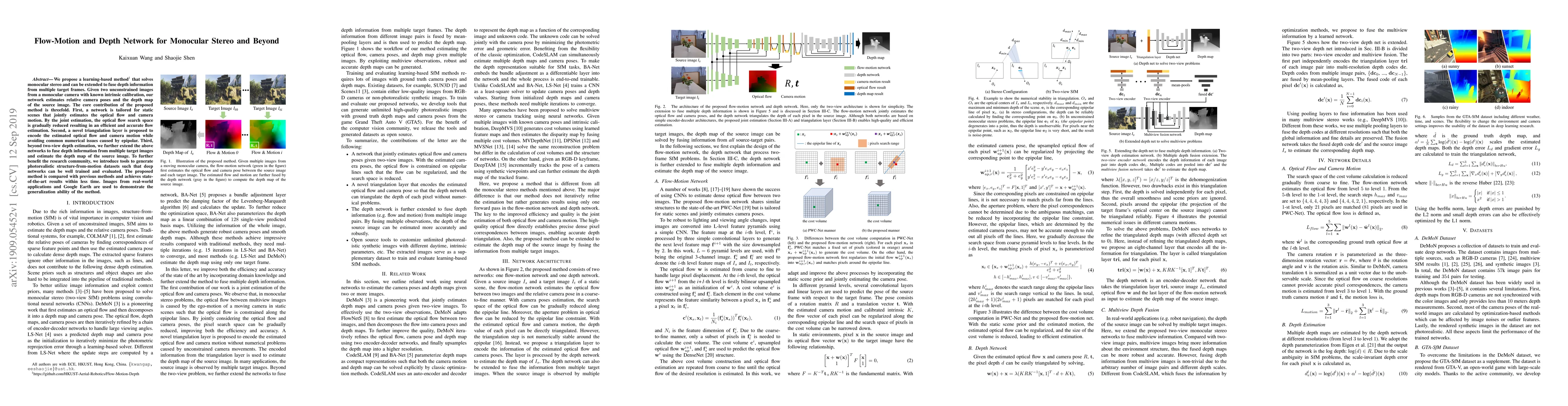
We propose a learning-based method that solves monocular stereo and can be extended to fuse depth information from multiple target frames. Given two unconstrained images from a monocular camera with...
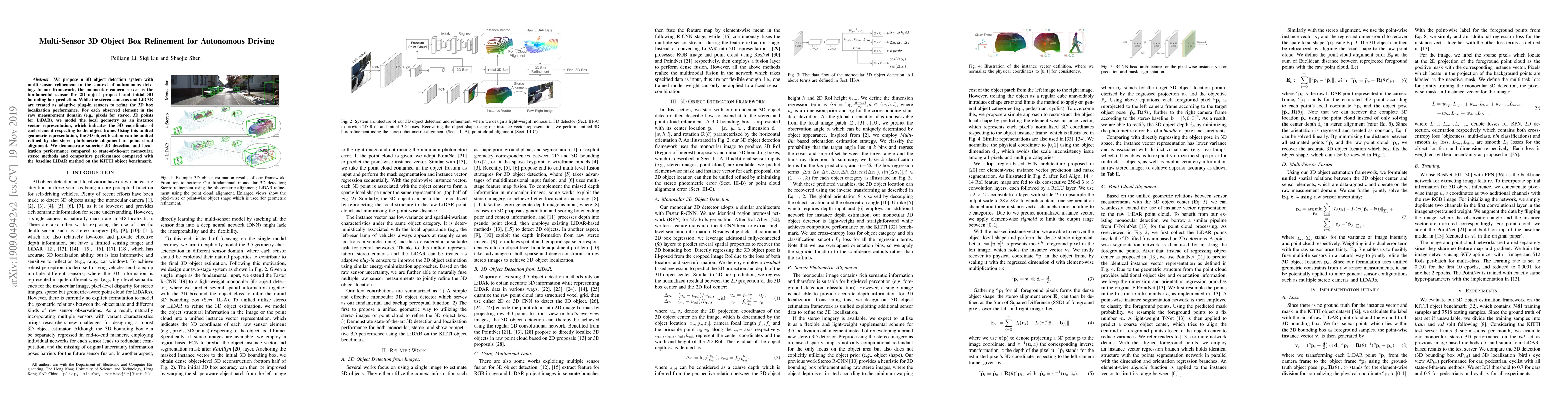
We propose a 3D object detection system with multi-sensor refinement in the context of autonomous driving. In our framework, the monocular camera serves as the fundamental sensor for 2D object propo...
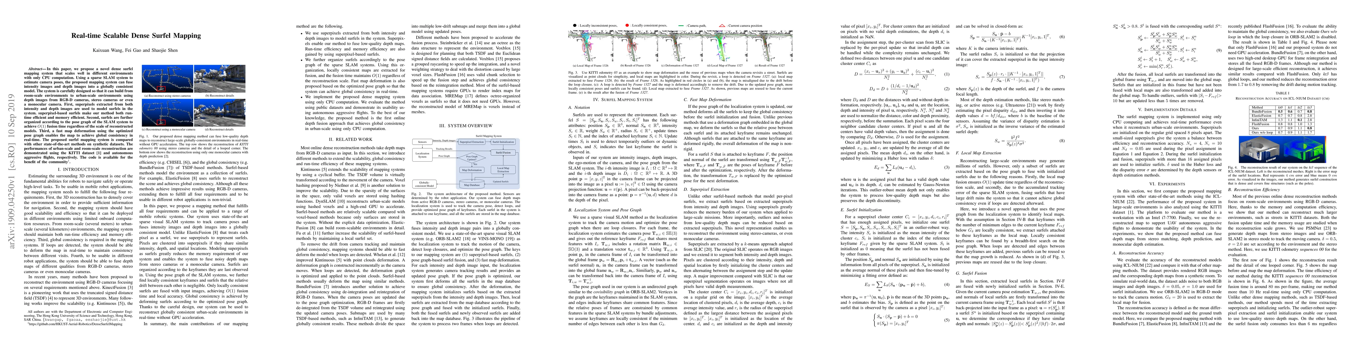
In this paper, we propose a novel dense surfel mapping system that scales well in different environments with only CPU computation. Using a sparse SLAM system to estimate camera poses, the proposed ...
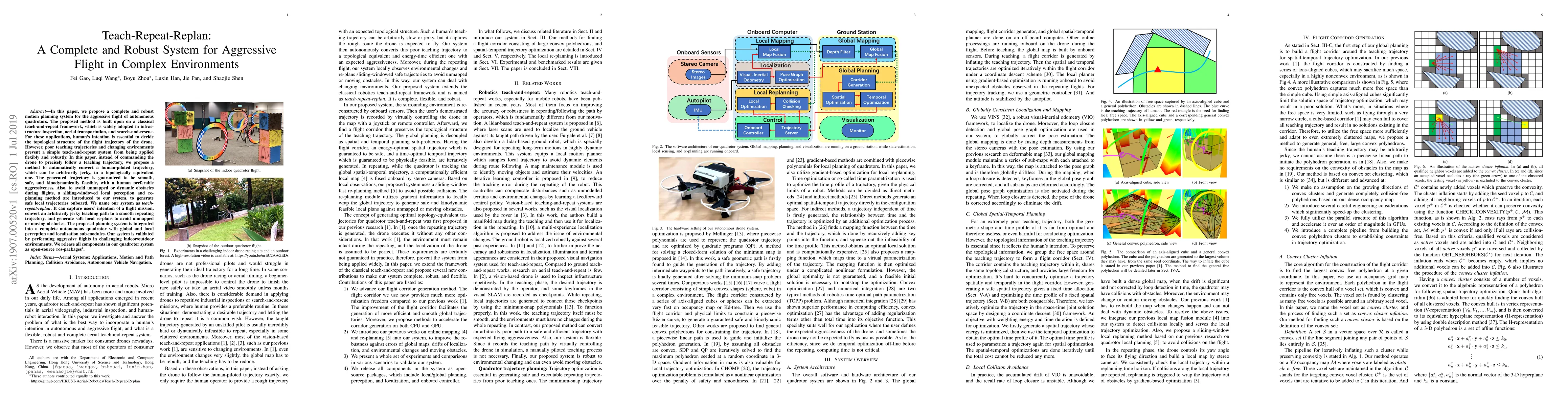
In this paper, we propose a complete and robust motion planning system for the aggressive flight of autonomous quadrotors. The proposed method is built upon on a classical teach-and-repeat framework...
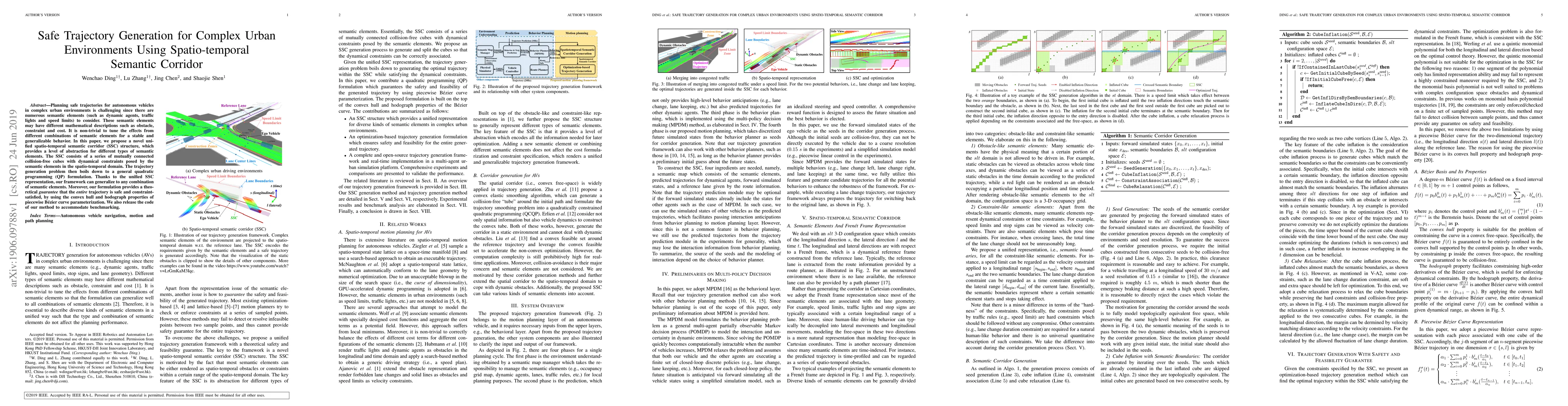
Planning safe trajectories for autonomous vehicles in complex urban environments is challenging since there are numerous semantic elements (such as dynamic agents, traffic lights and speed limits) t...
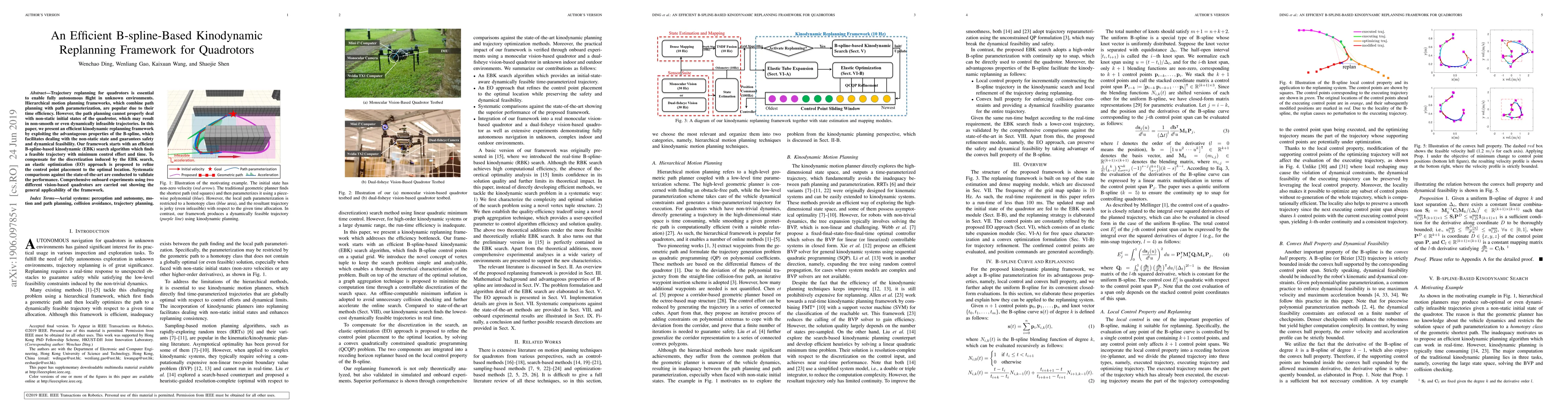
Trajectory replanning for quadrotors is essential to enable fully autonomous flight in unknown environments. Hierarchical motion planning frameworks, which combine path planning with path parameteri...
Autonomous exploration of unknown environments has been widely applied in inspection, surveillance, and search and rescue. In exploration task, the basic requirement for robots is to detect the unkn...
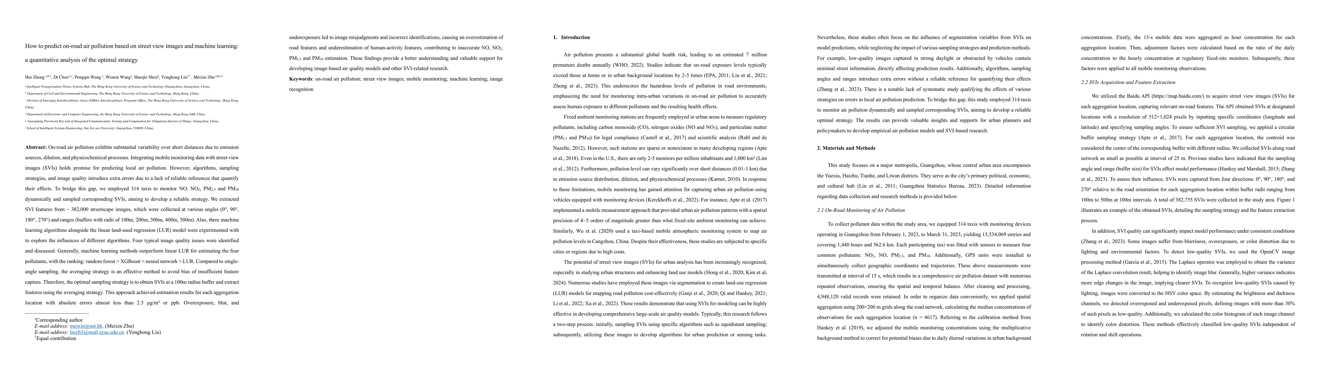
On-road air pollution exhibits substantial variability over short distances due to emission sources, dilution, and physicochemical processes. Integrating mobile monitoring data with street view images...
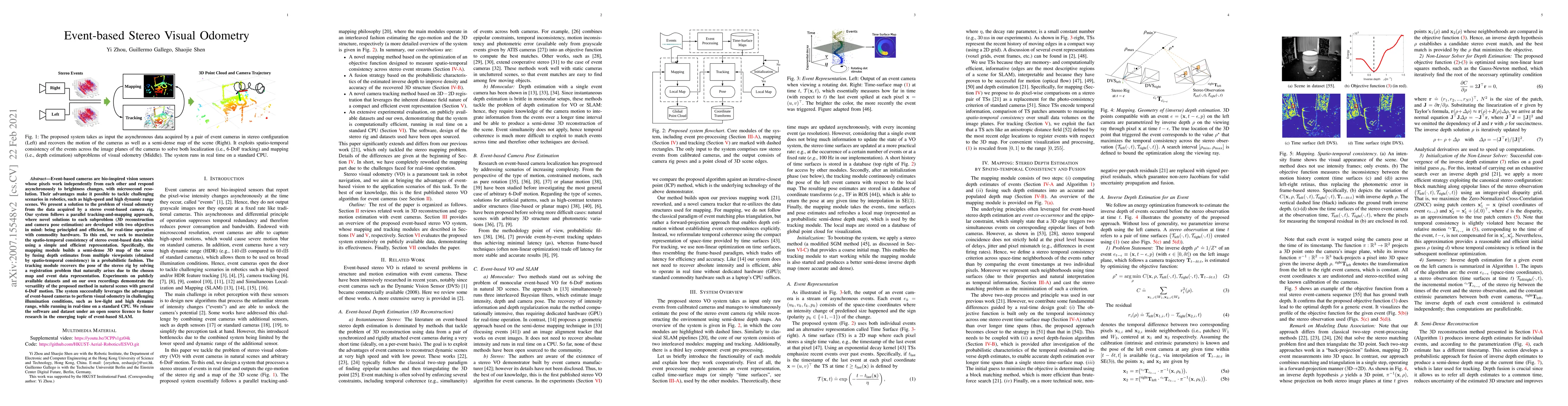
Event-based visual odometry is a specific branch of visual Simultaneous Localization and Mapping (SLAM) techniques, which aims at solving tracking and mapping sub-problems in parallel by exploiting th...
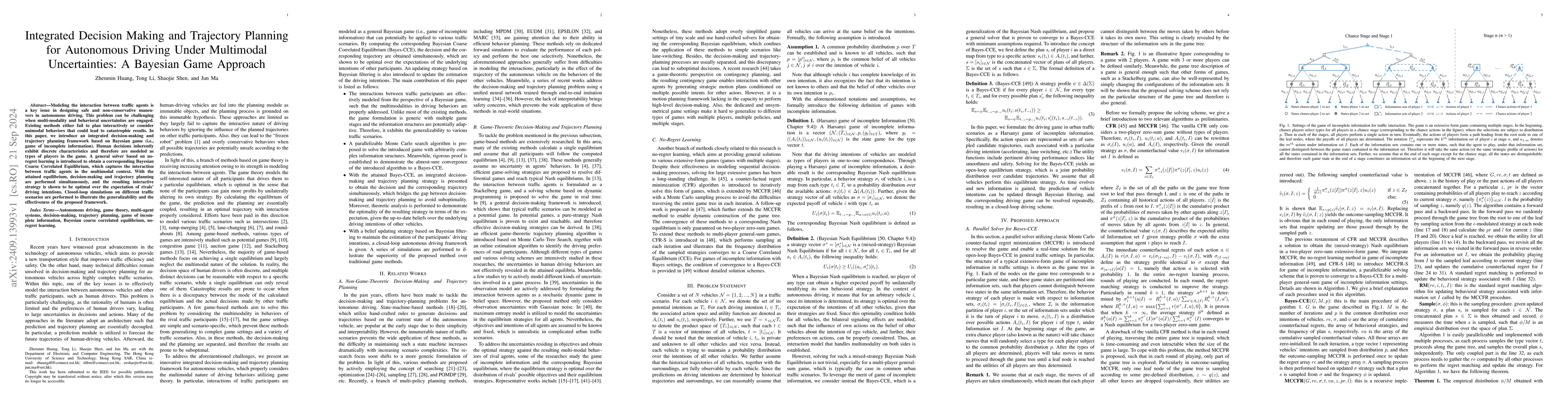
Modeling the interaction between traffic agents is a key issue in designing safe and non-conservative maneuvers in autonomous driving. This problem can be challenging when multi-modality and behaviora...
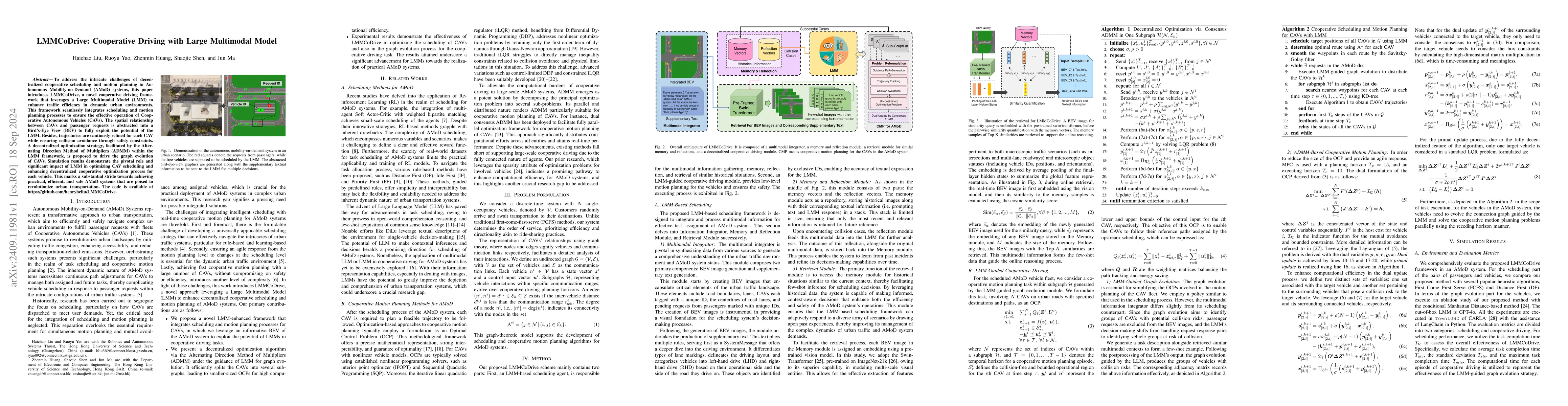
To address the intricate challenges of decentralized cooperative scheduling and motion planning in Autonomous Mobility-on-Demand (AMoD) systems, this paper introduces LMMCoDrive, a novel cooperative d...
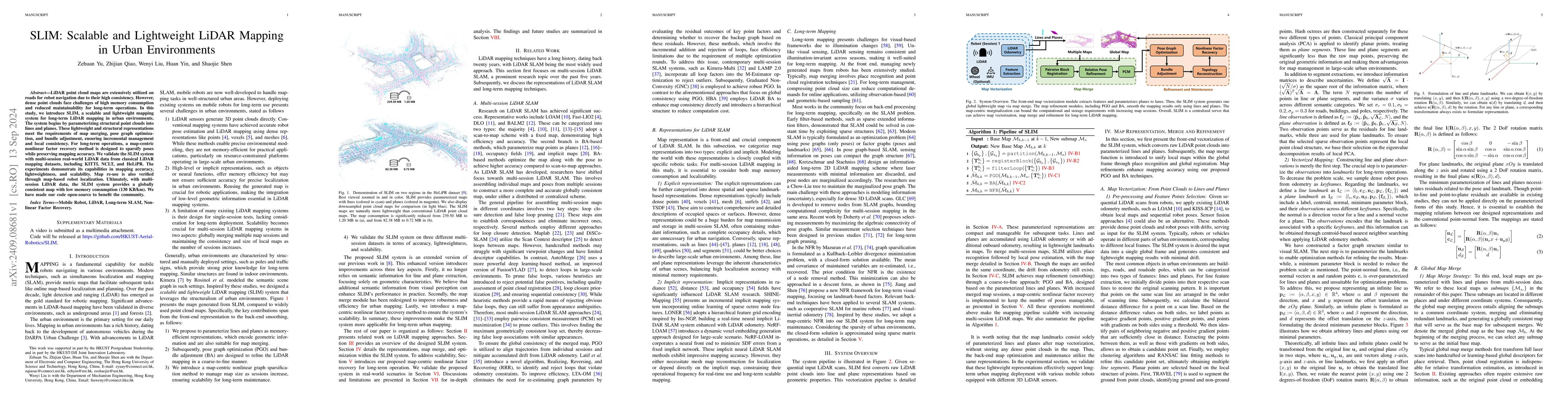
LiDAR point cloud maps are extensively utilized on roads for robot navigation due to their high consistency. However, dense point clouds face challenges of high memory consumption and reduced maintain...
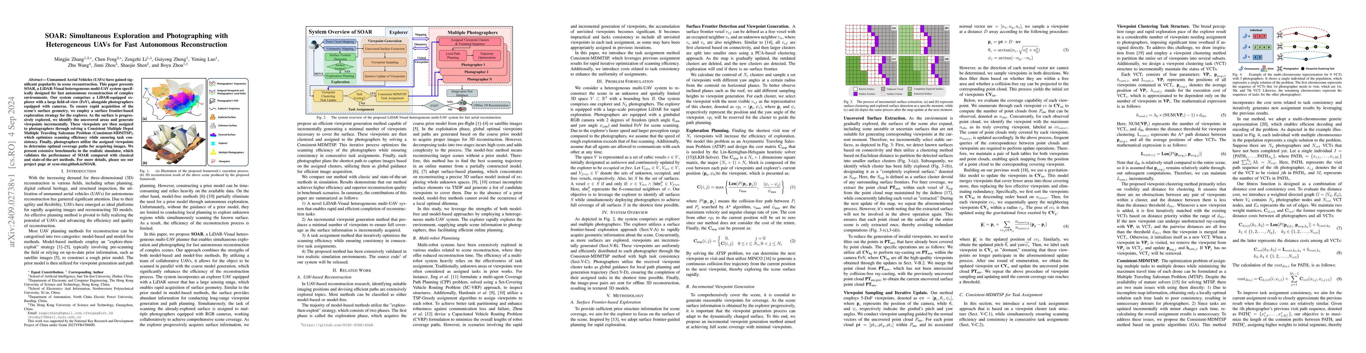
Unmanned Aerial Vehicles (UAVs) have gained significant popularity in scene reconstruction. This paper presents SOAR, a LiDAR-Visual heterogeneous multi-UAV system specifically designed for fast auton...
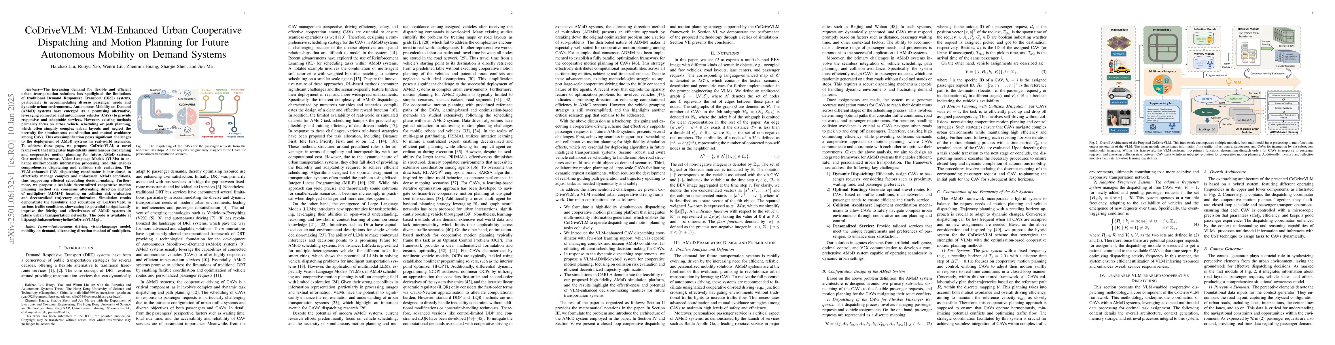
The increasing demand for flexible and efficient urban transportation solutions has spotlighted the limitations of traditional Demand Responsive Transport (DRT) systems, particularly in accommodating ...
In recent years, 3D Gaussian splatting (3D-GS) has emerged as a novel scene representation approach. However, existing vision-only 3D-GS methods often rely on hand-crafted heuristics for point-cloud d...
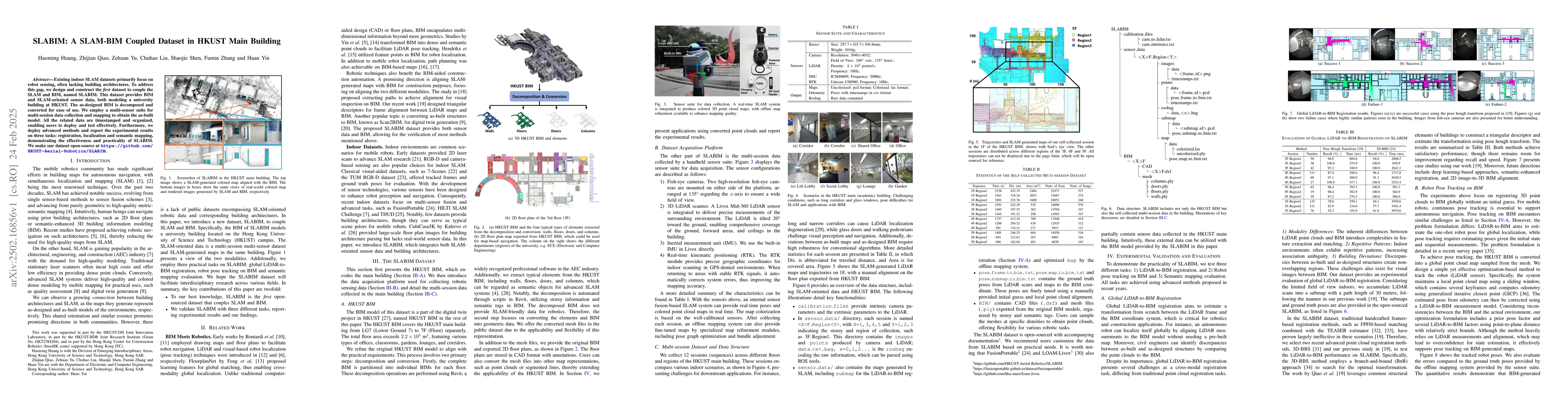
Existing indoor SLAM datasets primarily focus on robot sensing, often lacking building architectures. To address this gap, we design and construct the first dataset to couple the SLAM and BIM, named S...
Most existing methods for motion planning of mobile robots involve generating collision-free trajectories. However, these methods focusing solely on contact avoidance may limit the robots' locomotion ...
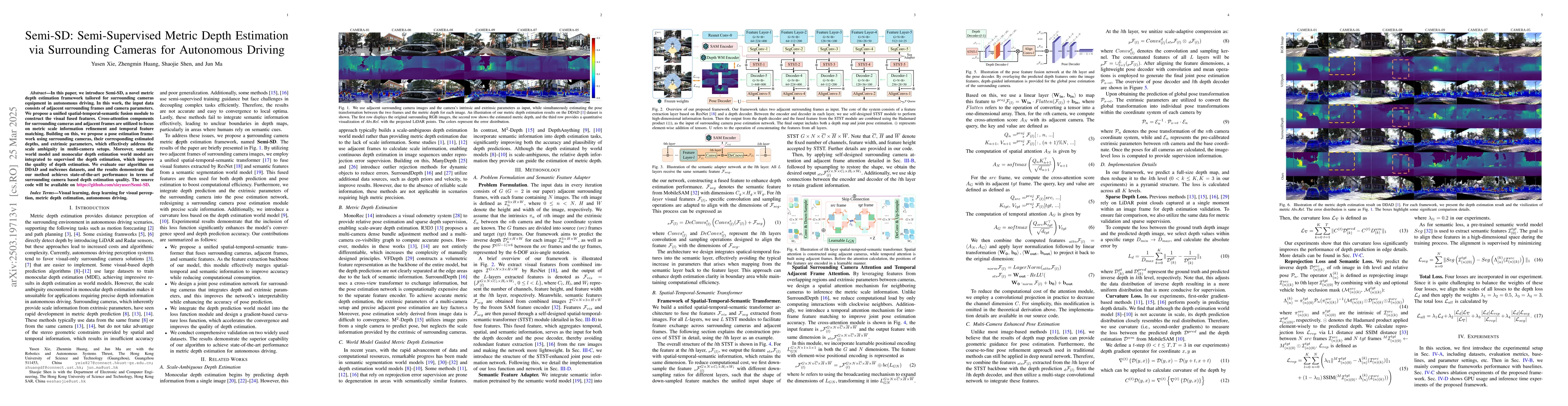
In this paper, we introduce Semi-SD, a novel metric depth estimation framework tailored for surrounding cameras equipment in autonomous driving. In this work, the input data consists of adjacent surro...
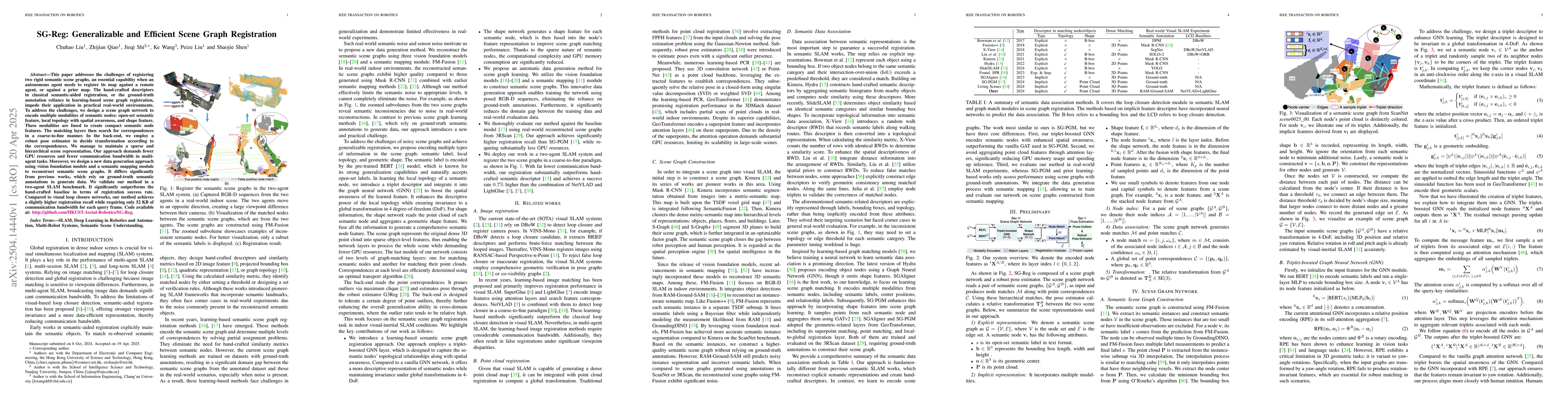
This paper addresses the challenges of registering two rigid semantic scene graphs, an essential capability when an autonomous agent needs to register its map against a remote agent, or against a prio...
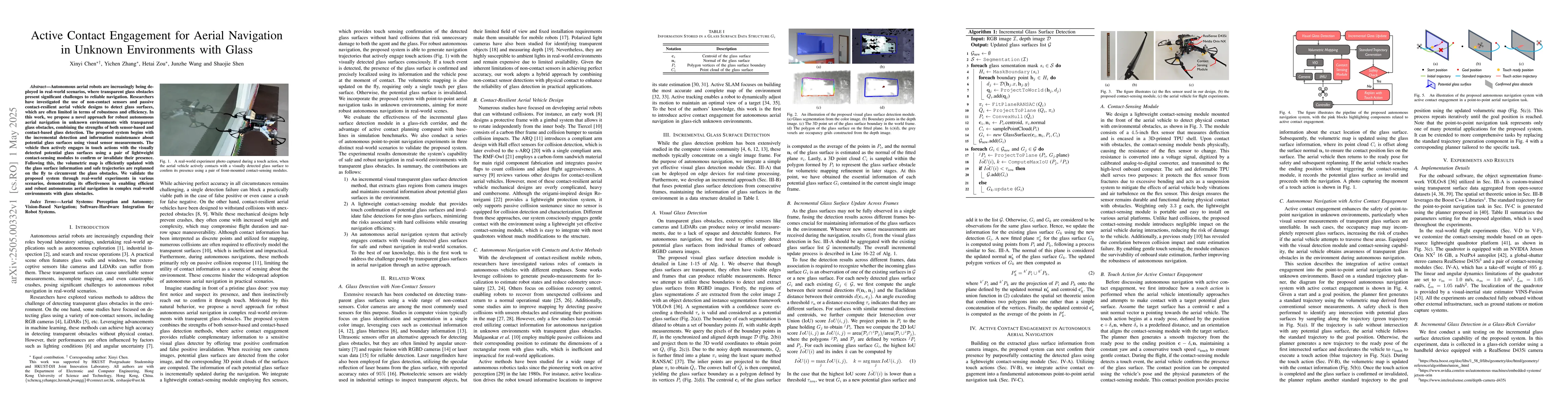
Autonomous aerial robots are increasingly being deployed in real-world scenarios, where transparent glass obstacles present significant challenges to reliable navigation. Researchers have investigated...
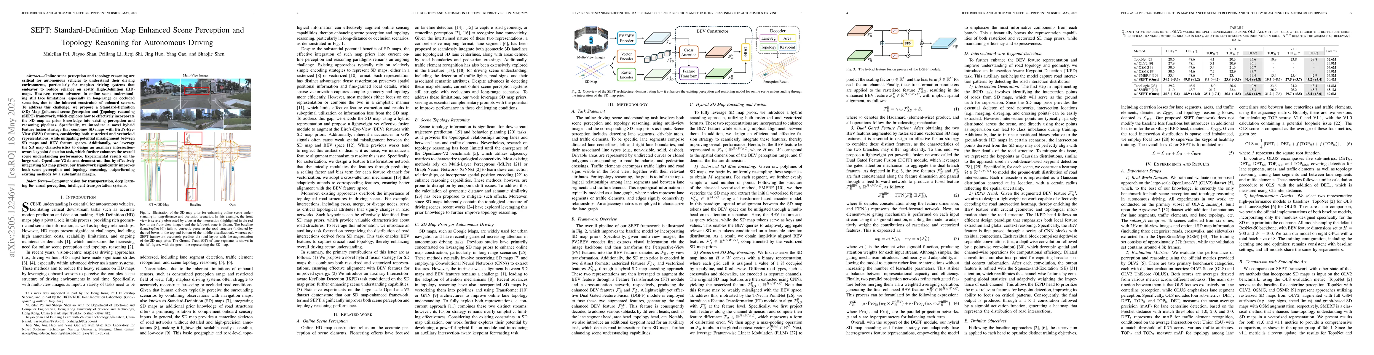
Online scene perception and topology reasoning are critical for autonomous vehicles to understand their driving environments, particularly for mapless driving systems that endeavor to reduce reliance ...
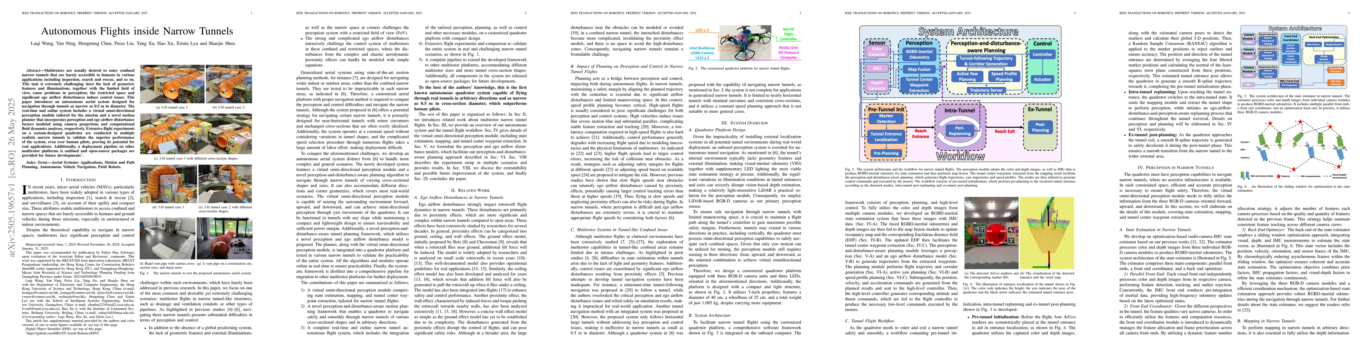
Multirotors are usually desired to enter confined narrow tunnels that are barely accessible to humans in various applications including inspection, search and rescue, and so on. This task is extremely...
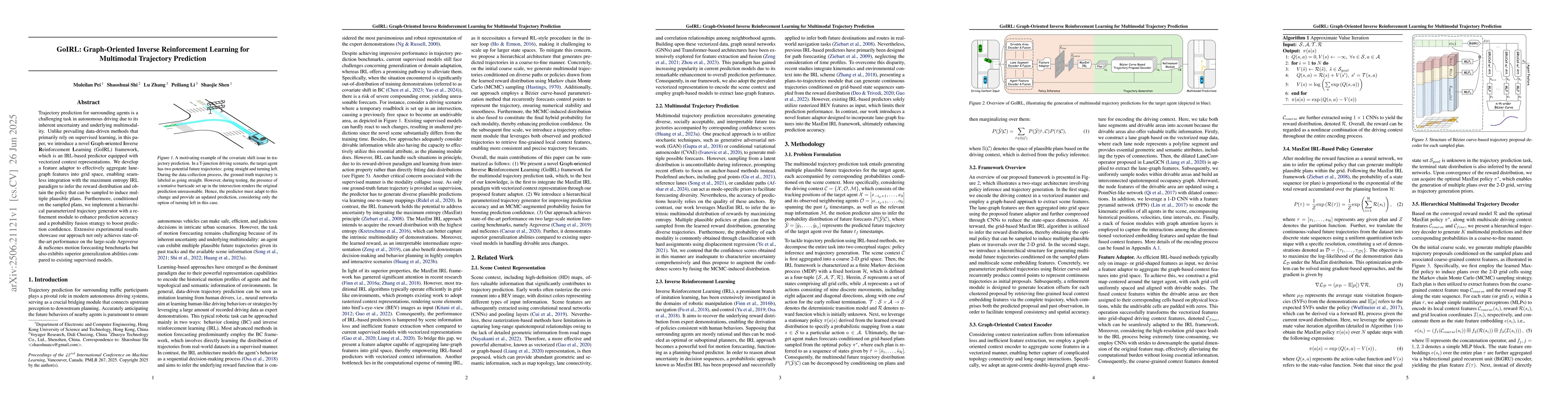
Trajectory prediction for surrounding agents is a challenging task in autonomous driving due to its inherent uncertainty and underlying multimodality. Unlike prevailing data-driven methods that primar...
Motion forecasting for on-road traffic agents presents both a significant challenge and a critical necessity for ensuring safety in autonomous driving systems. In contrast to most existing data-driven...
Trajectory planning involving multi-agent interactions has been a long-standing challenge in the field of robotics, primarily burdened by the inherent yet intricate interactions among agents. While ga...
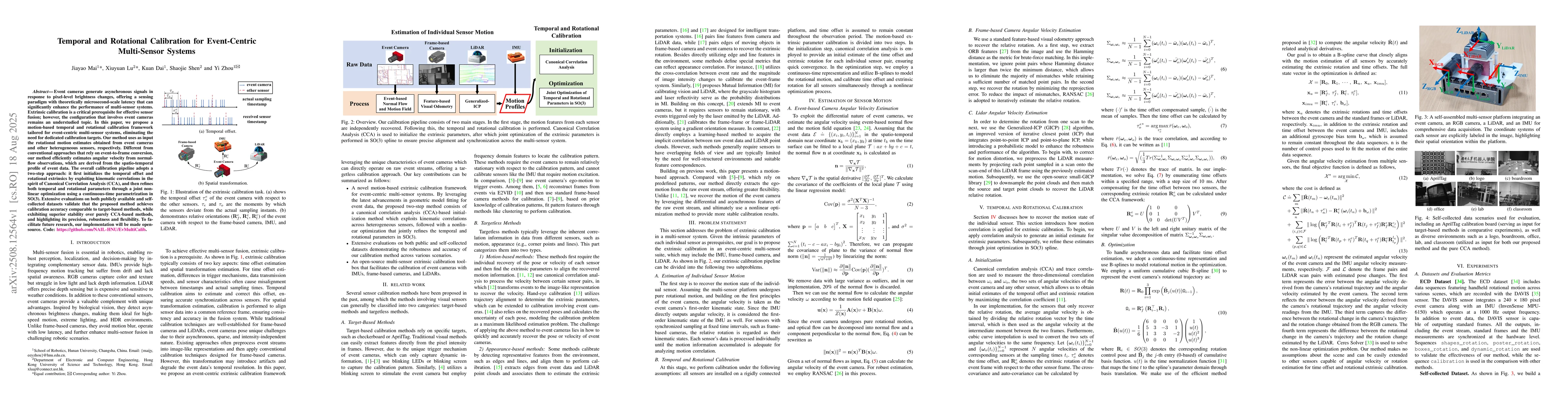
Event cameras generate asynchronous signals in response to pixel-level brightness changes, offering a sensing paradigm with theoretically microsecond-scale latency that can significantly enhance the p...
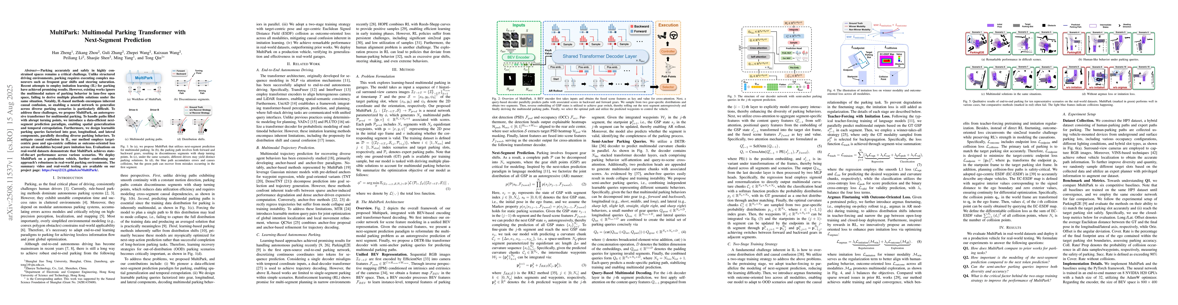
Parking accurately and safely in highly constrained spaces remains a critical challenge. Unlike structured driving environments, parking requires executing complex maneuvers such as frequent gear shif...
3D occupancy prediction is critical for comprehensive scene understanding in vision-centric autonomous driving. Recent advances have explored utilizing 3D semantic Gaussians to model occupancy while r...
Scalable and realistic simulation of multi-agent traffic behavior is critical for advancing autonomous driving technologies. Although existing data-driven simulators have made significant strides in t...
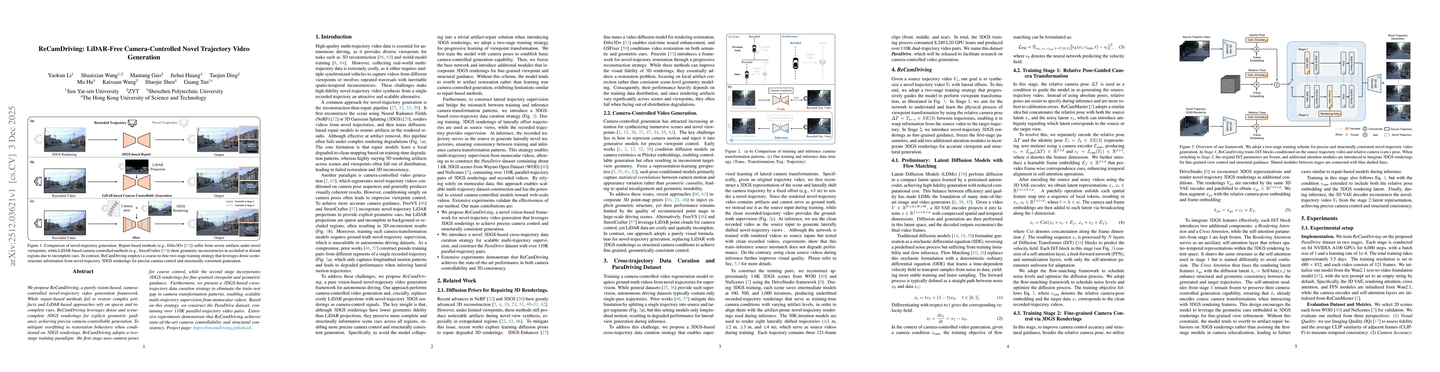
We propose ReCamDriving, a purely vision-based, camera-controlled novel-trajectory video generation framework. While repair-based methods fail to restore complex artifacts and LiDAR-based approaches r...
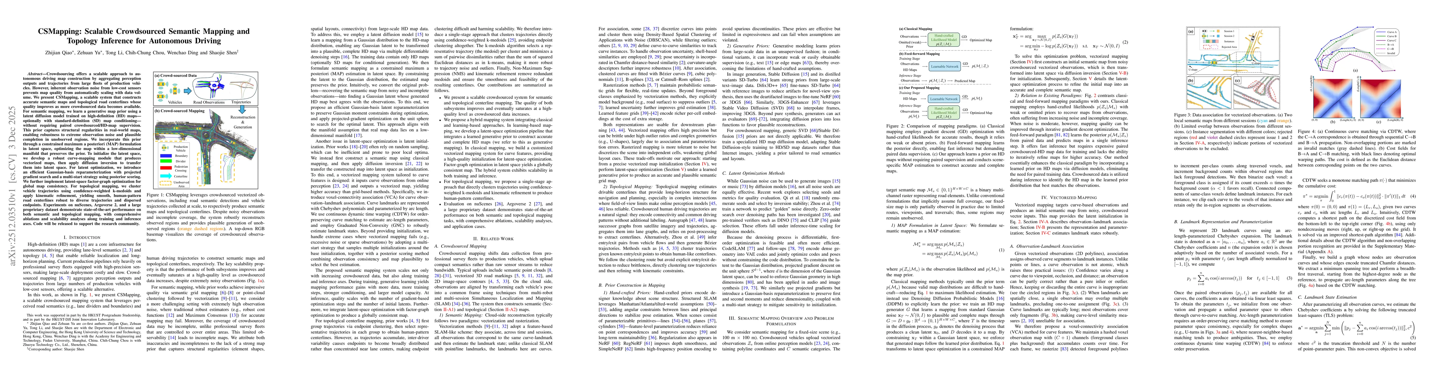
Crowdsourcing enables scalable autonomous driving map construction, but low-cost sensor noise hinders quality from improving with data volume. We propose CSMapping, a system that produces accurate sem...
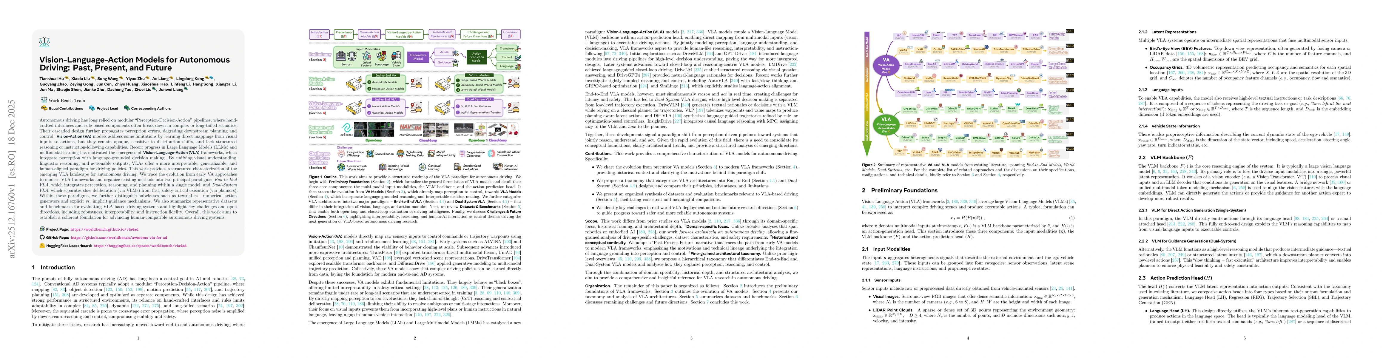
Autonomous driving has long relied on modular "Perception-Decision-Action" pipelines, where hand-crafted interfaces and rule-based components often break down in complex or long-tailed scenarios. Thei...
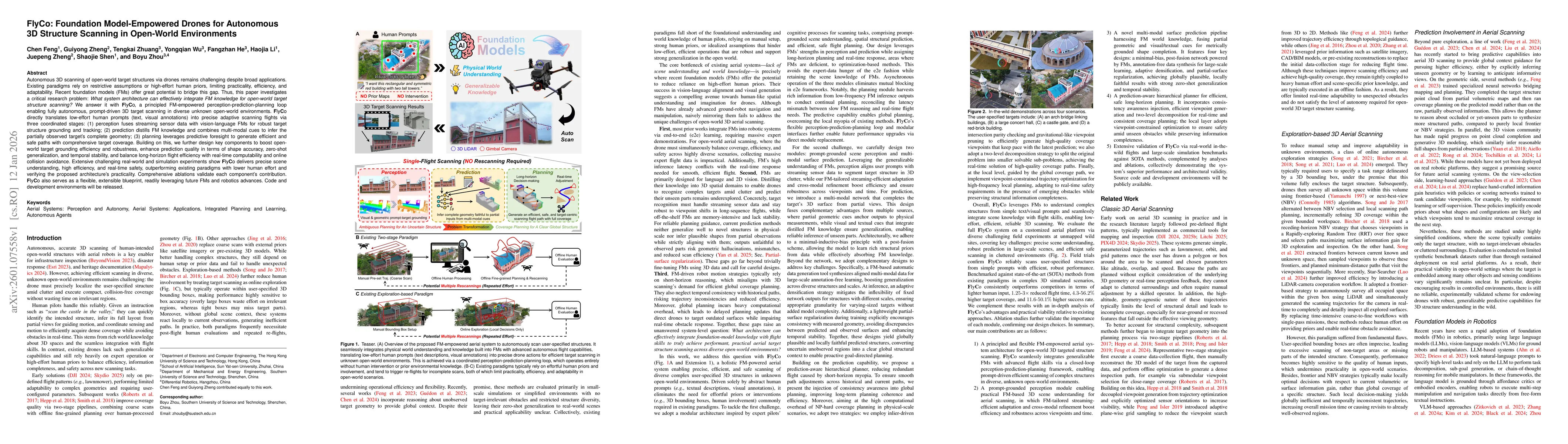
Autonomous 3D scanning of open-world target structures via drones remains challenging despite broad applications. Existing paradigms rely on restrictive assumptions or effortful human priors, limiting...

Gaussian Splatting (GS) has demonstrated impressive quality and efficiency in novel view synthesis. However, shape extraction from Gaussian primitives remains an open problem. Due to inadequate geomet...
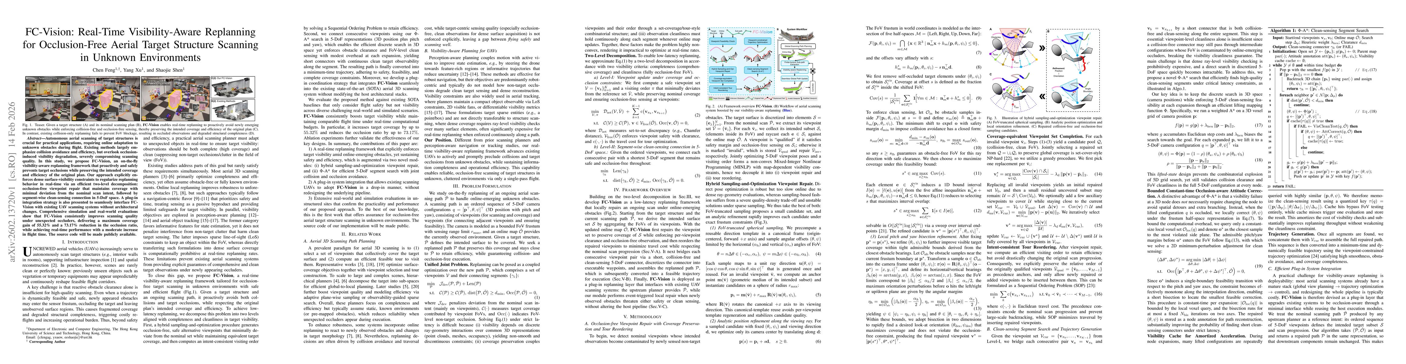
Autonomous aerial scanning of target structures is crucial for practical applications, requiring online adaptation to unknown obstacles during flight. Existing methods largely emphasize collision avoi...
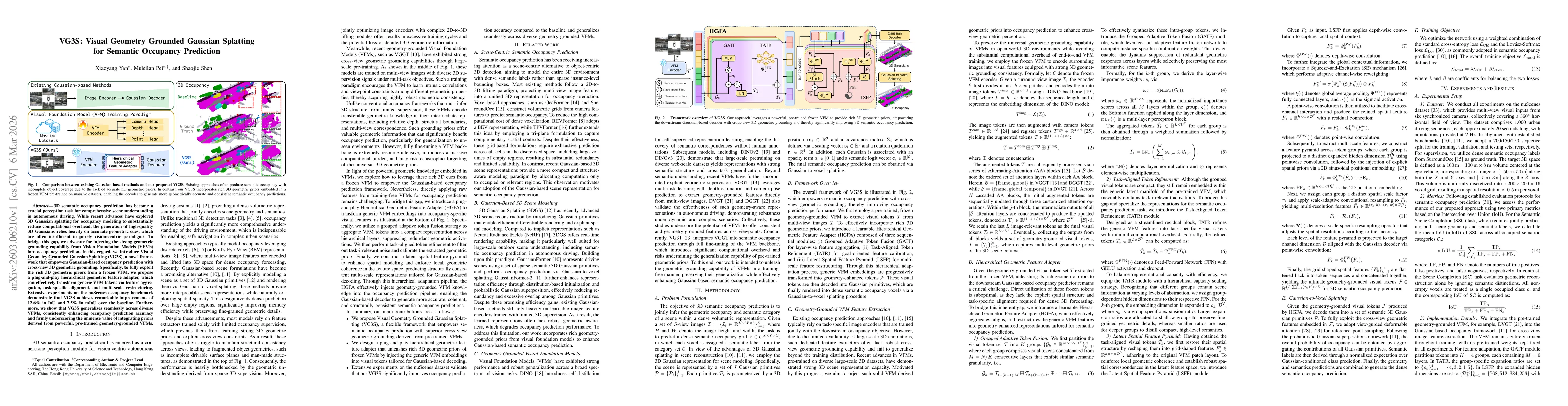
3D semantic occupancy prediction has become a crucial perception task for comprehensive scene understanding in autonomous driving. While recent advances have explored 3D Gaussian splatting for occupan...
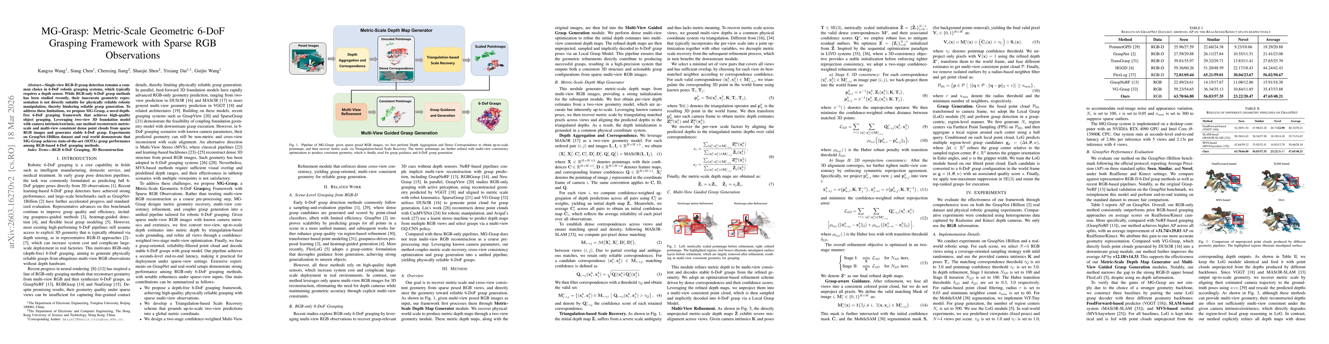
Single-view RGB-D grasp detection remains a com- mon choice in 6-DoF robotic grasping systems, which typically requires a depth sensor. While RGB-only 6-DoF grasp methods has been studied recently, th...
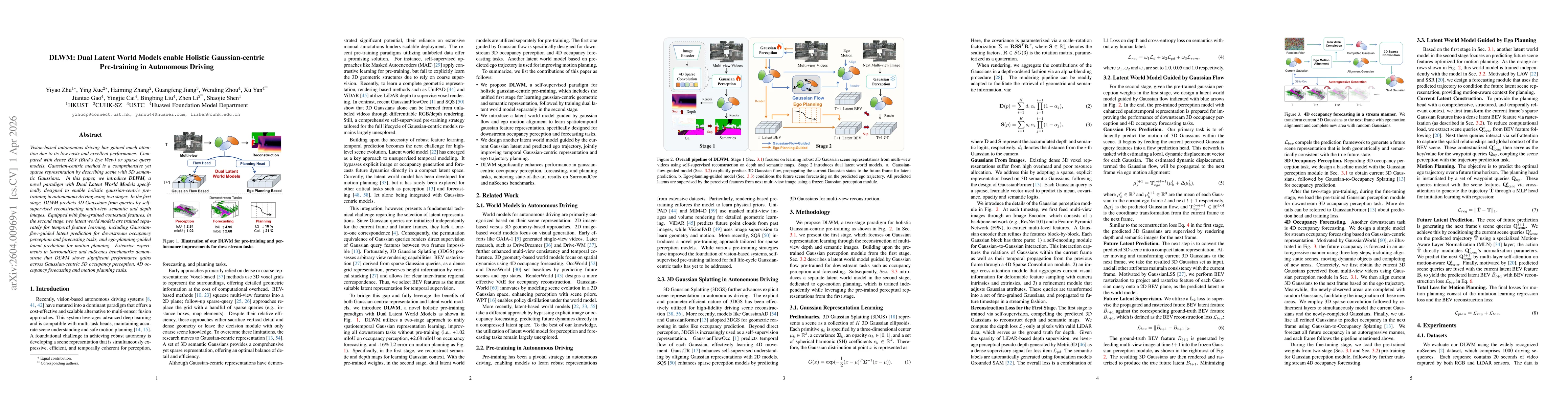
Vision-based autonomous driving has gained much attention due to its low costs and excellent performance. Compared with dense BEV (Bird's Eye View) or sparse query models, Gaussian-centric method is a...
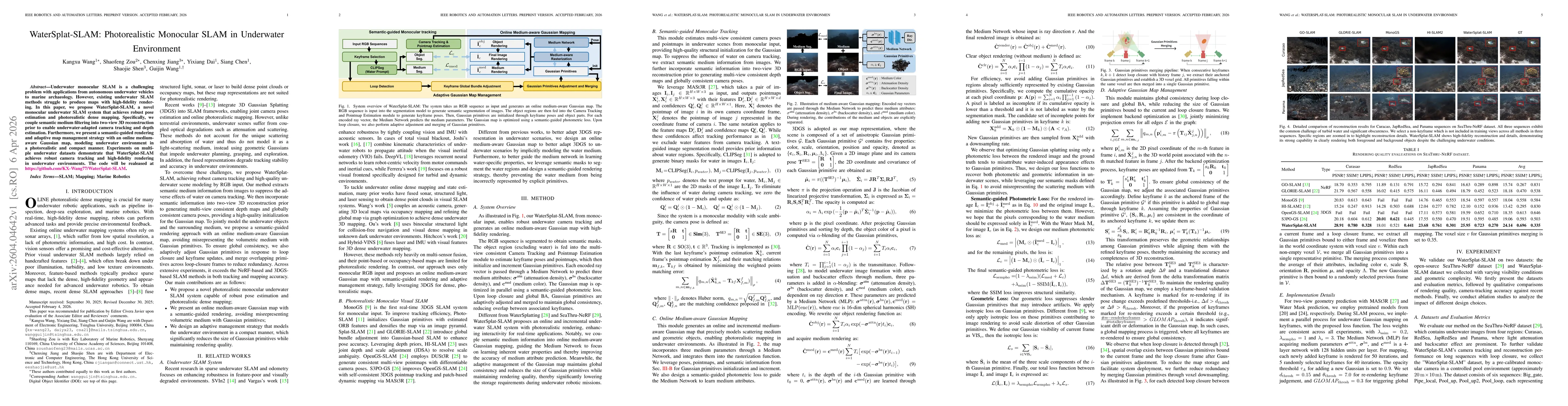
Underwater monocular SLAM is a challenging problem with applications from autonomous underwater vehicles to marine archaeology. However, existing underwater SLAM methods struggle to produce maps with ...
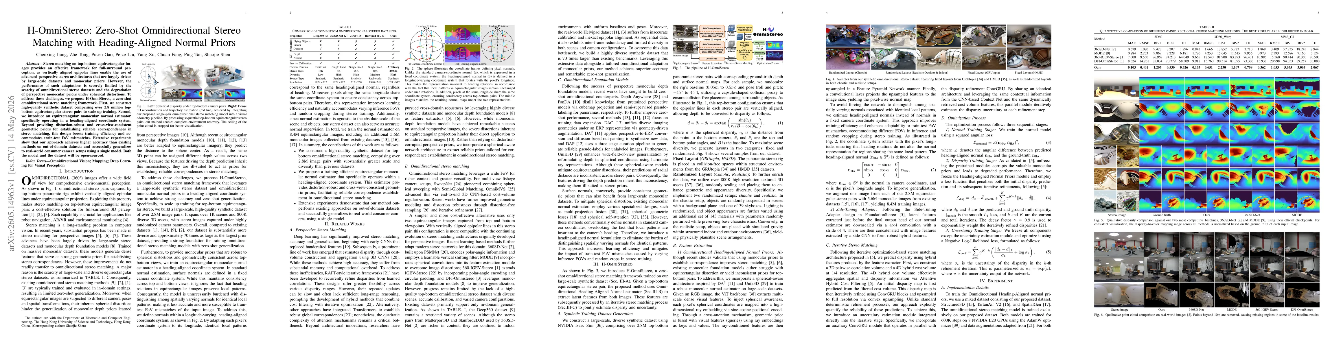
Stereo matching on top-bottom equirectangular images provides an effective framework for full-surround perception, as vertically aligned epipolar lines enable the use of advanced perspective stereo ar...
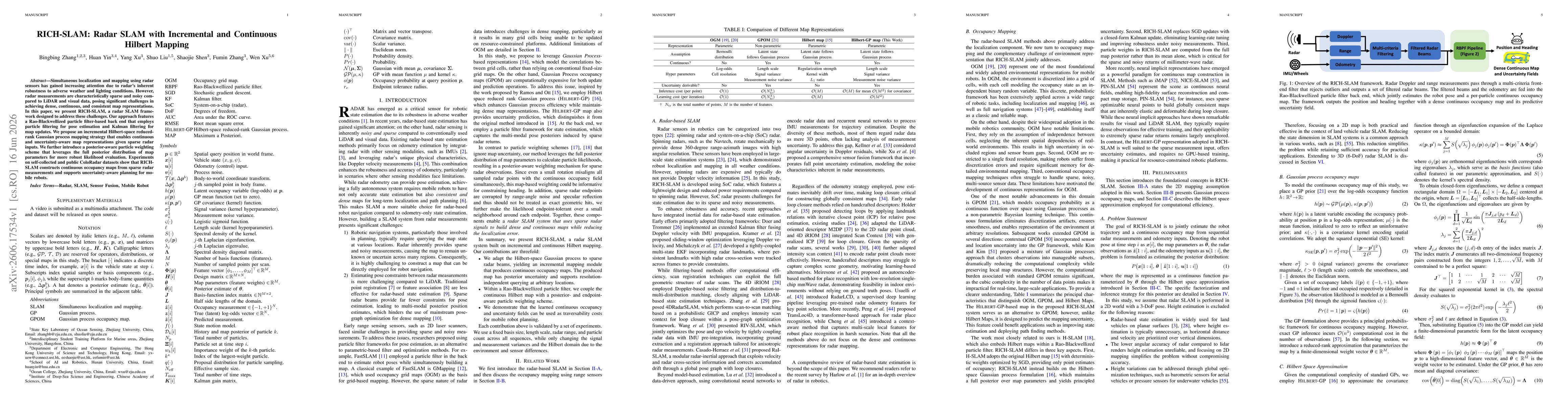
Simultaneous localization and mapping using radar sensors has gained increasing attention due to radar's inherent robustness to adverse weather and lighting conditions. However, radar measurements are...
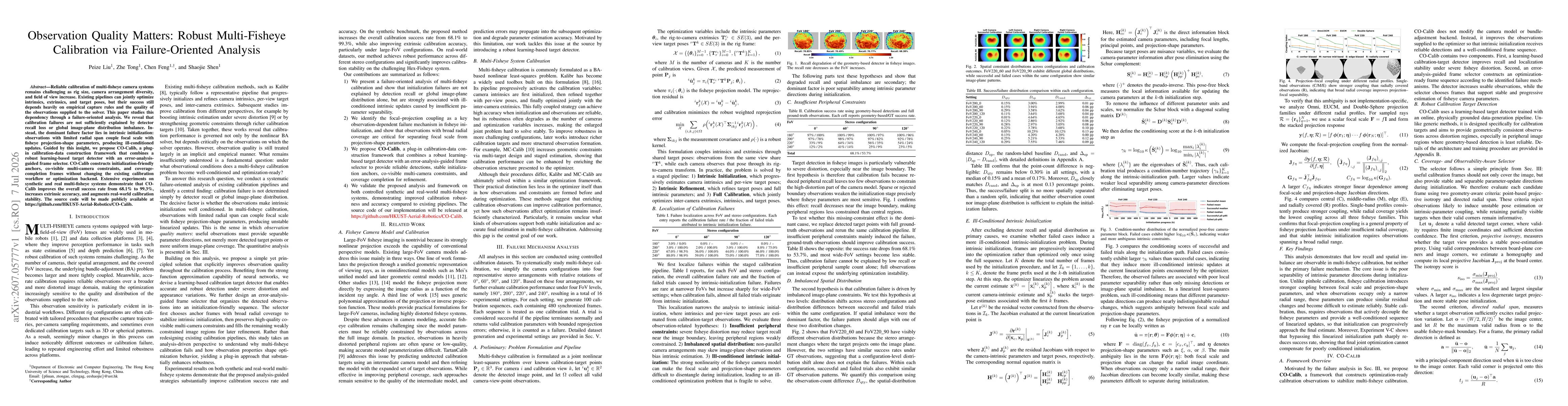
Reliable calibration of multi-fisheye camera systems remains challenging as rig size, camera arrangement diversity, and field of view increase. Existing pipelines can jointly optimize intrinsics, extr...