Academic Profile
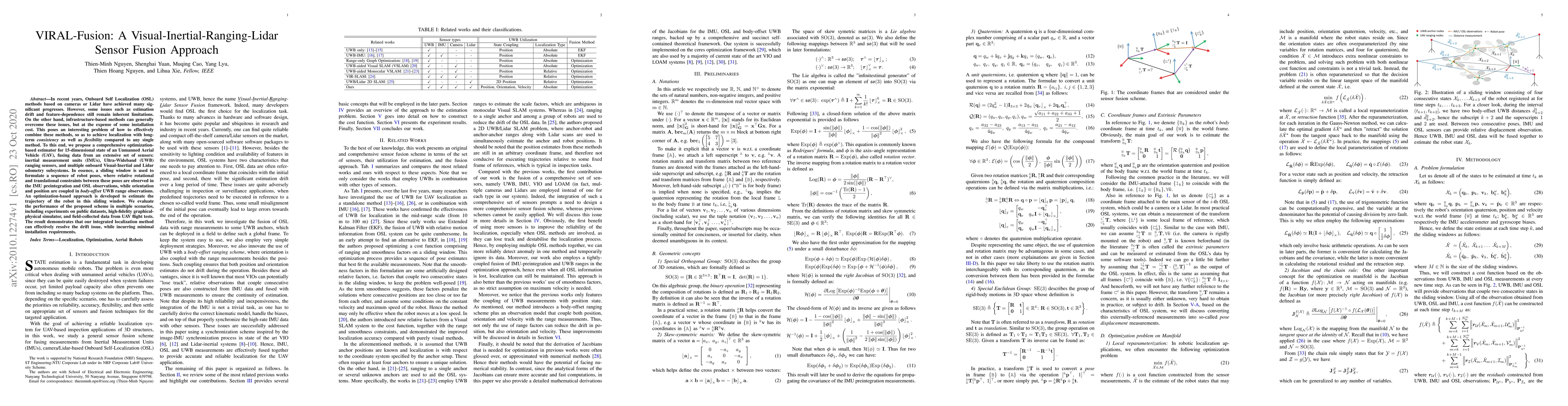
Statistics
Similar Authors
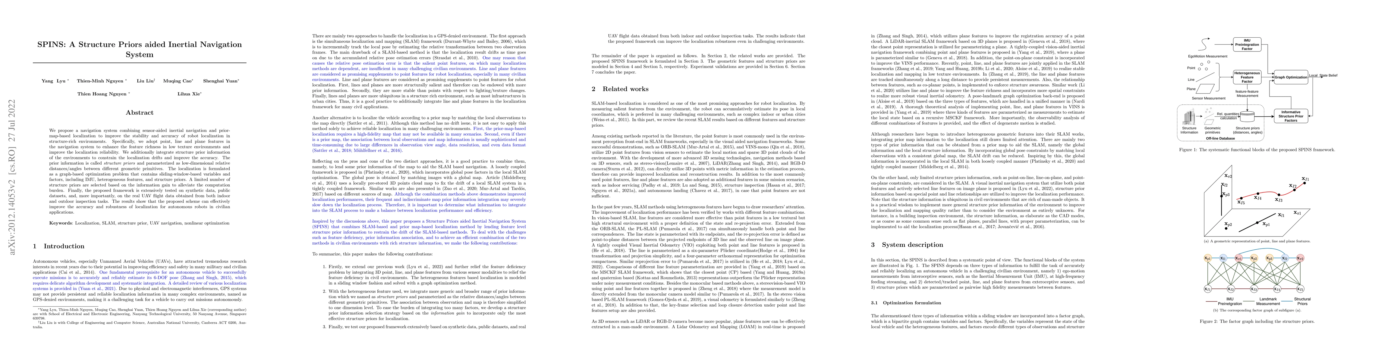
Papers on arXiv
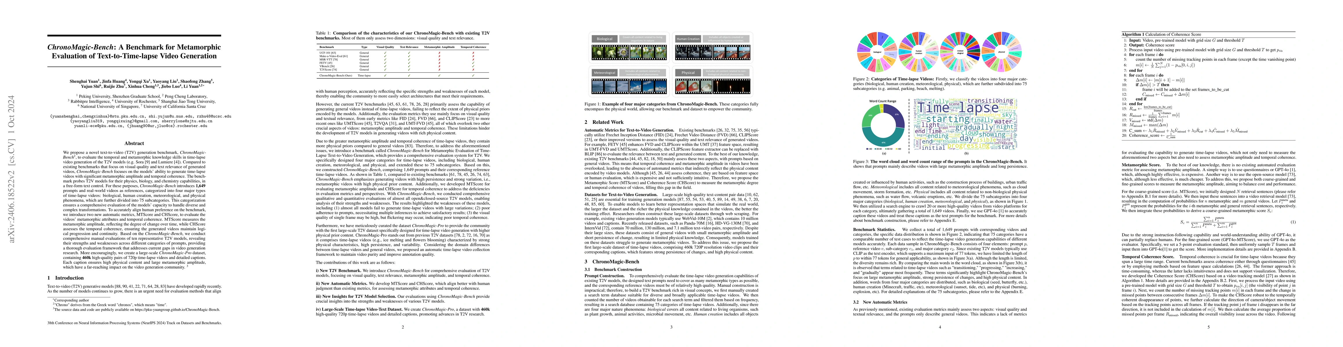
We propose a novel text-to-video (T2V) generation benchmark, ChronoMagic-Bench, to evaluate the temporal and metamorphic capabilities of the T2V models (e.g. Sora and Lumiere) in time-lapse video gene...
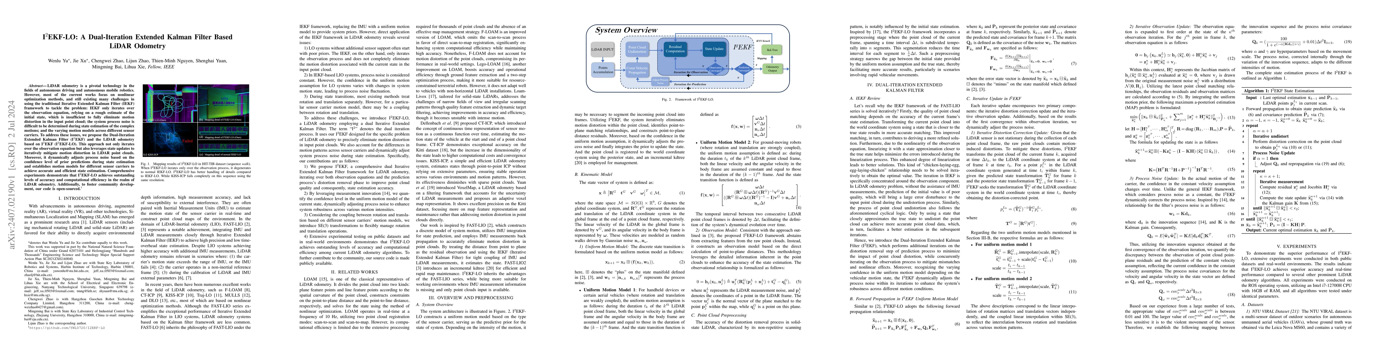
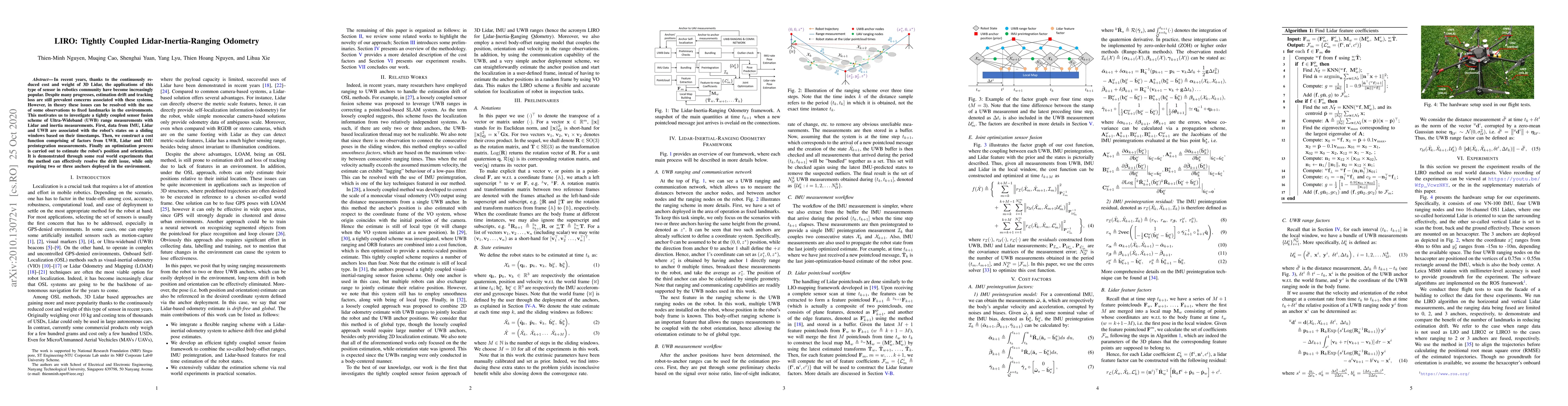
LiDAR odometry is a pivotal technology in the fields of autonomous driving and autonomous mobile robotics. However, most of the current works focus on nonlinear optimization methods, and still exist...
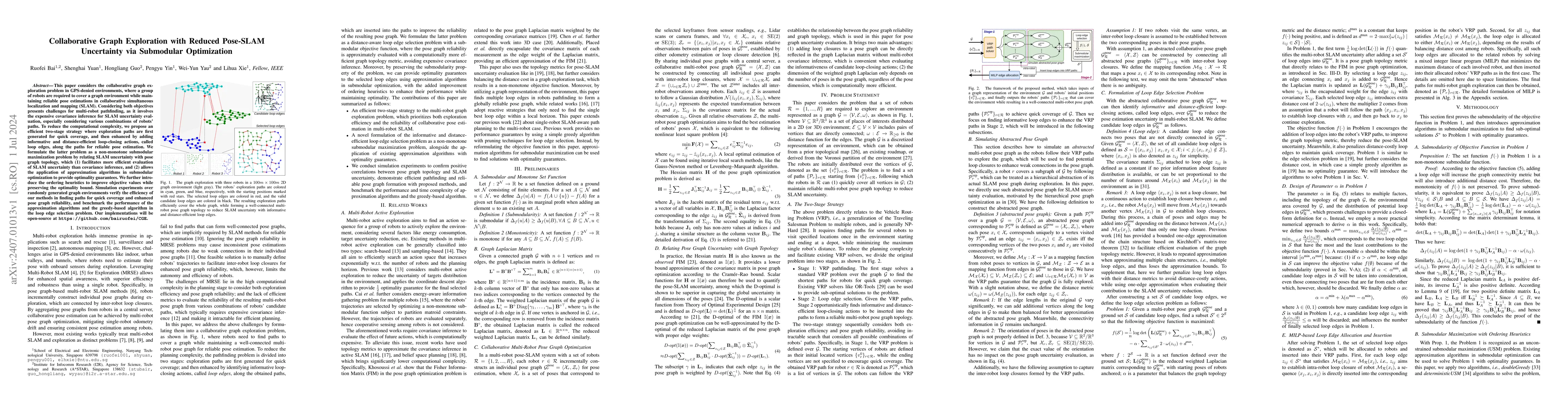
This paper considers the collaborative graph exploration problem in GPS-denied environments, where a group of robots are required to cover a graph environment while maintaining reliable pose estimat...
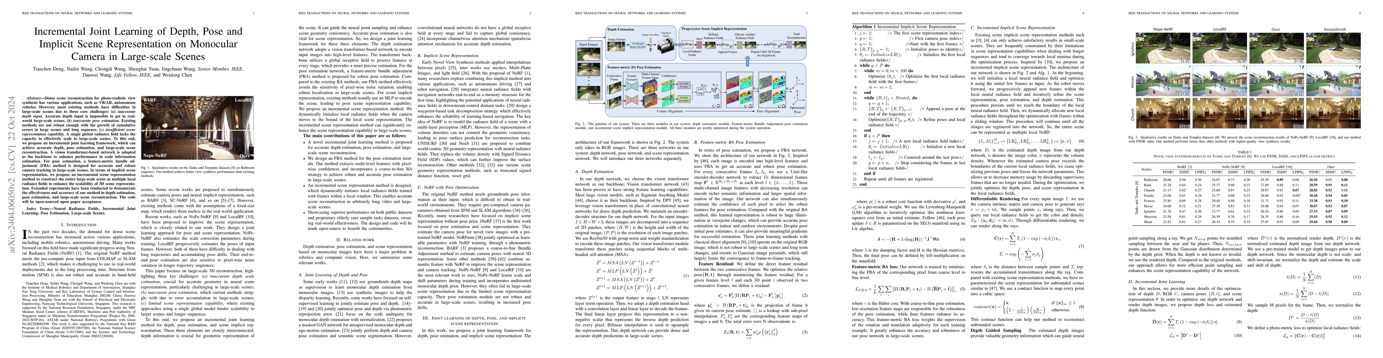
Dense scene reconstruction for photo-realistic view synthesis has various applications, such as VR/AR, autonomous vehicles. However, most existing methods have difficulties in large-scale scenes due...
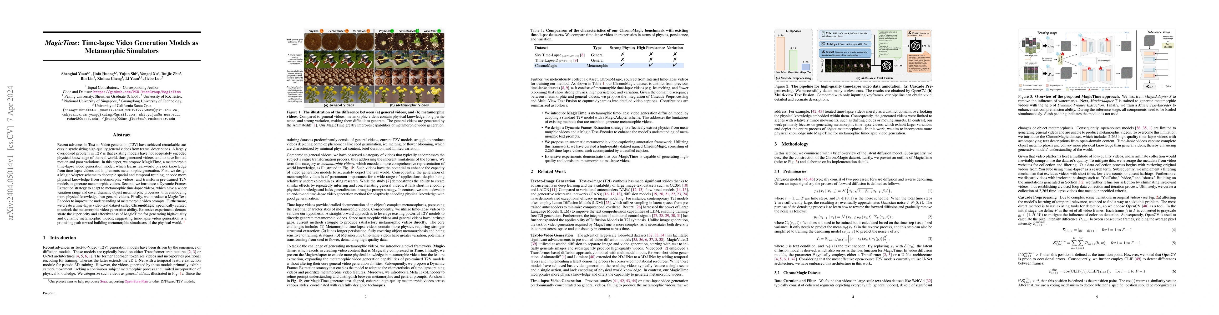
Recent advances in Text-to-Video generation (T2V) have achieved remarkable success in synthesizing high-quality general videos from textual descriptions. A largely overlooked problem in T2V is that ...
Visual Odometry (VO) is vital for the navigation of autonomous systems, providing accurate position and orientation estimates at reasonable costs. While traditional VO methods excel in some conditio...
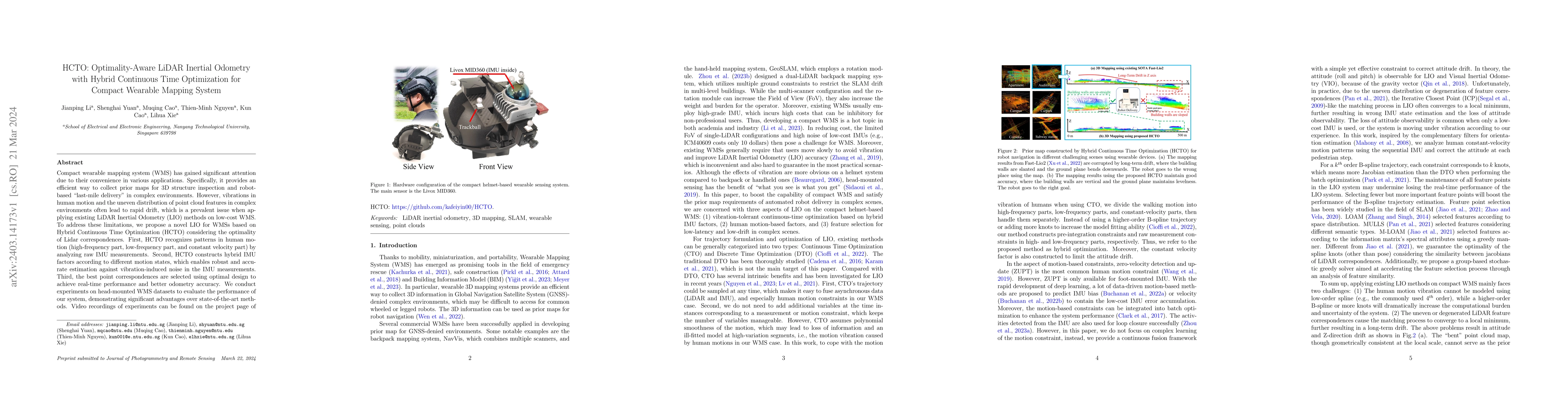
Compact wearable mapping system (WMS) has gained significant attention due to their convenience in various applications. Specifically, it provides an efficient way to collect prior maps for 3D struc...
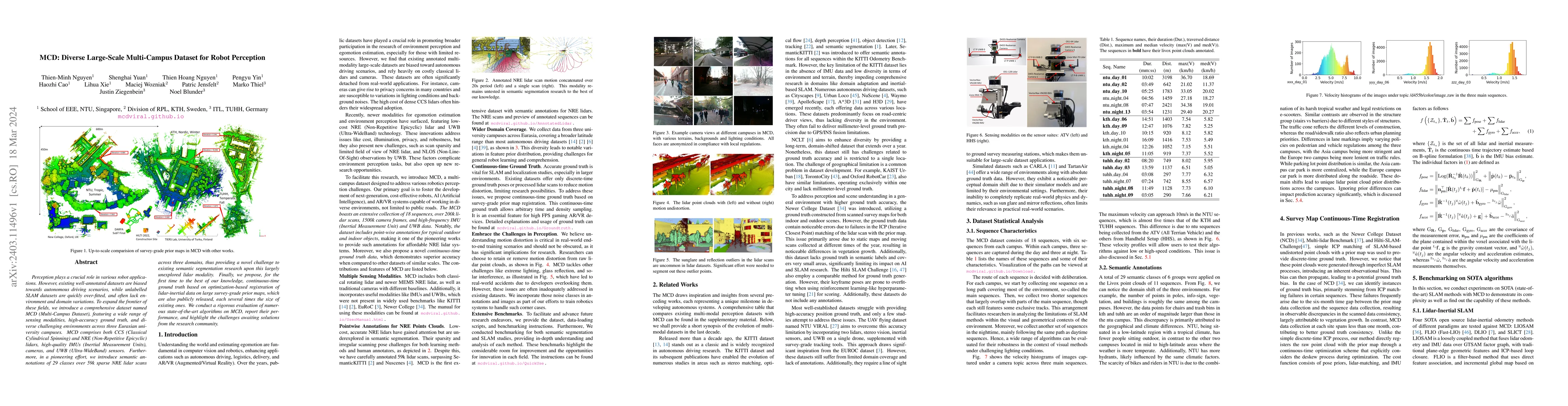
Perception plays a crucial role in various robot applications. However, existing well-annotated datasets are biased towards autonomous driving scenarios, while unlabelled SLAM datasets are quickly o...
Recent work has shown that 3D Gaussian-based SLAM enables high-quality reconstruction, accurate pose estimation, and real-time rendering of scenes. However, these approaches are built on a tremendou...
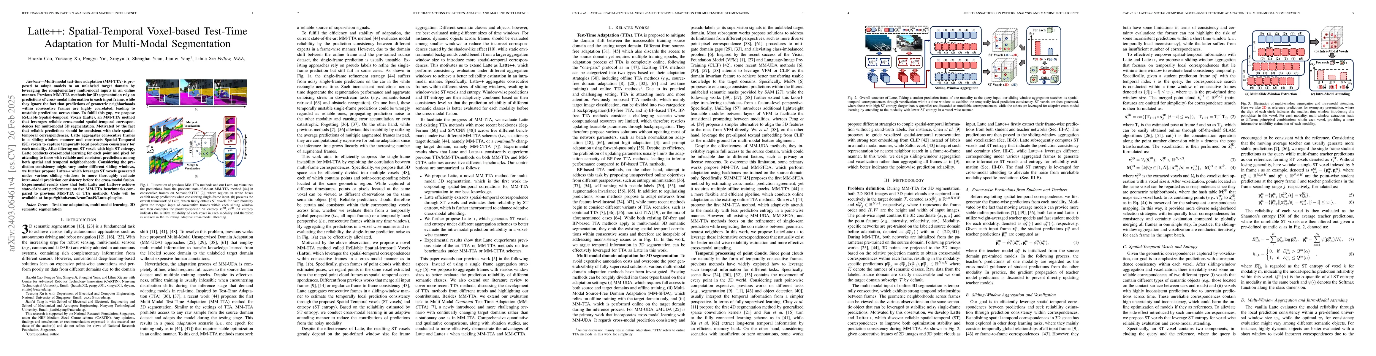
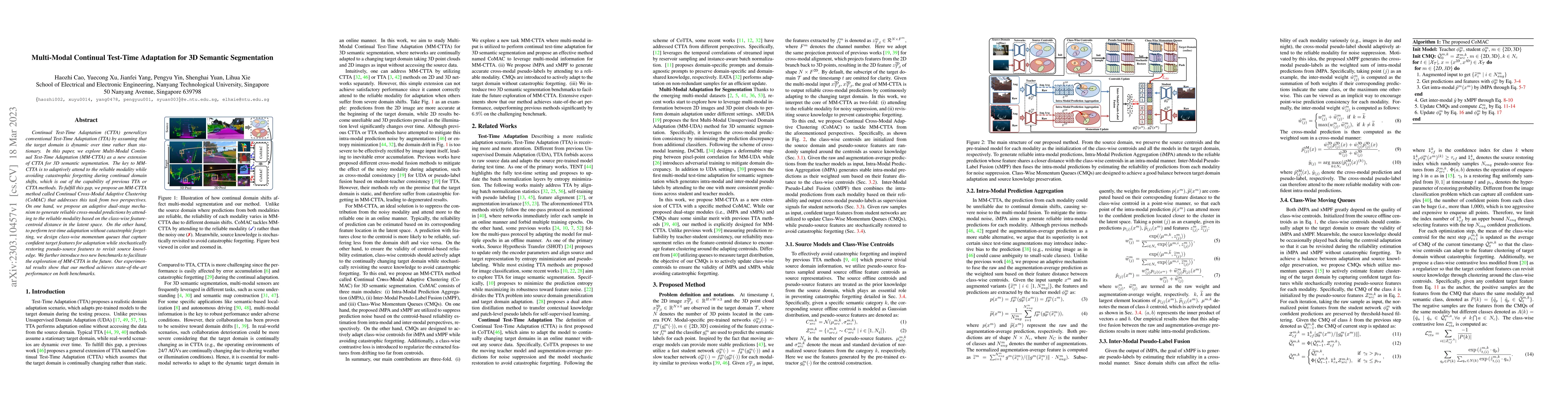
Multi-modal test-time adaptation (MM-TTA) is proposed to adapt models to an unlabeled target domain by leveraging the complementary multi-modal inputs in an online manner. Previous MM-TTA methods re...
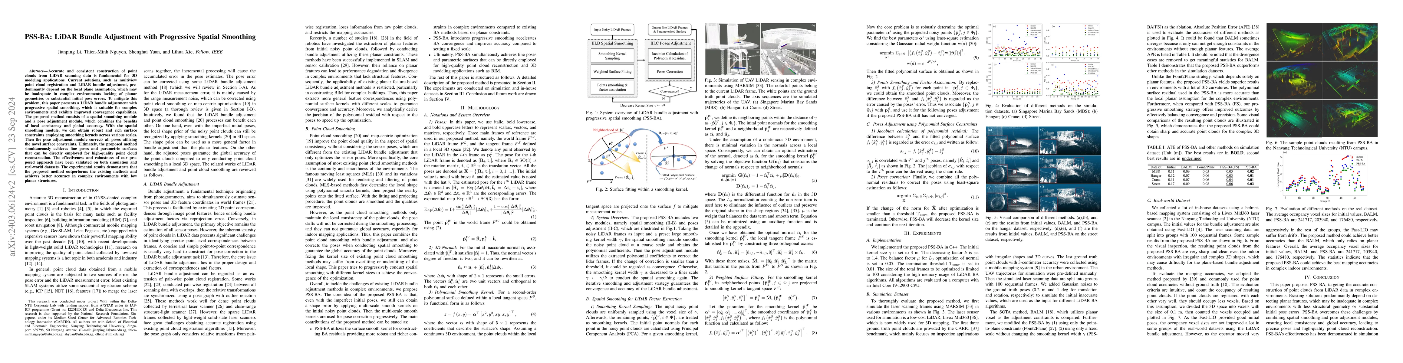
Accurate and consistent construction of point clouds from LiDAR scanning data is fundamental for 3D modeling applications. Current solutions, such as multiview point cloud registration and LiDAR bun...
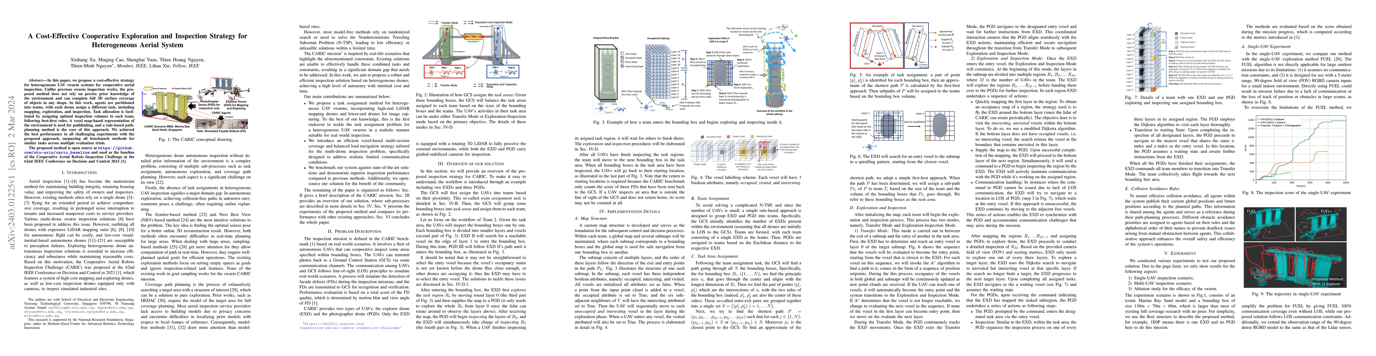
In this paper, we propose a cost-effective strategy for heterogeneous UAV swarm systems for cooperative aerial inspection. Unlike previous swarm inspection works, the proposed method does not rely o...
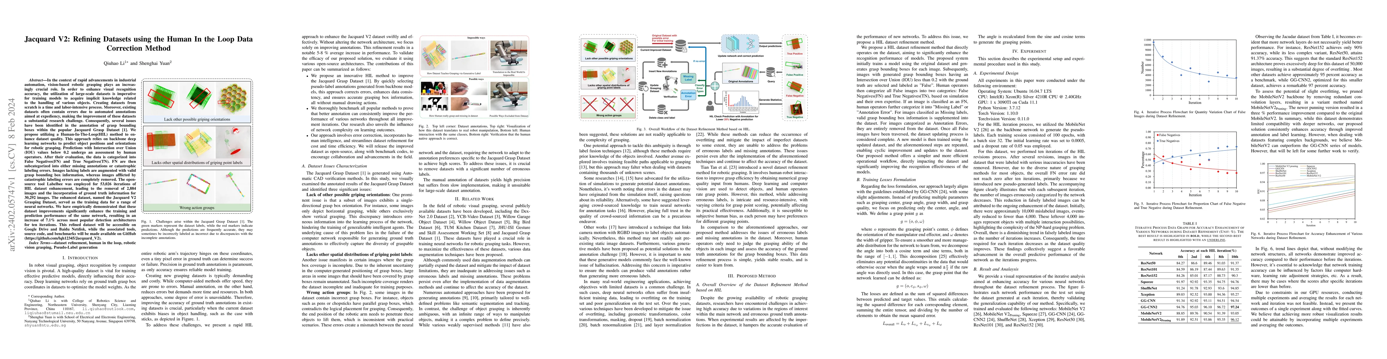
In the context of rapid advancements in industrial automation, vision-based robotic grasping plays an increasingly crucial role. In order to enhance visual recognition accuracy, the utilization of l...
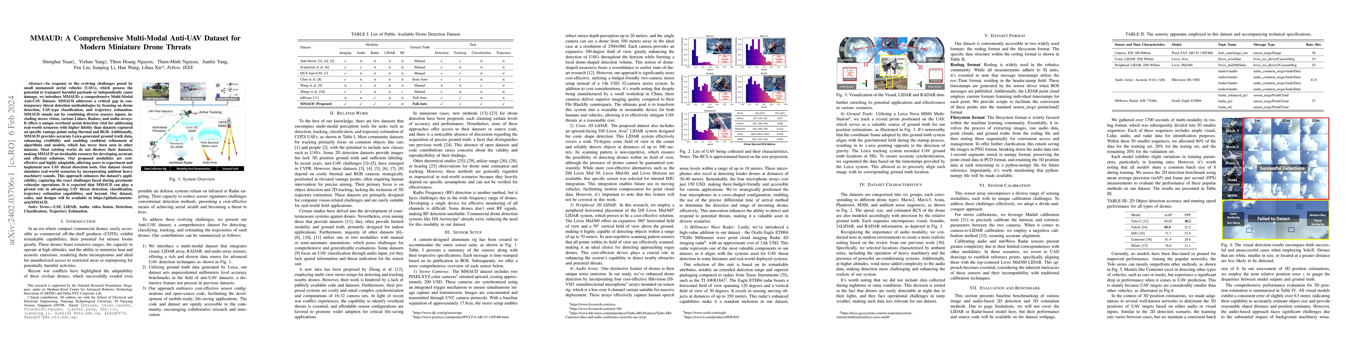
In response to the evolving challenges posed by small unmanned aerial vehicles (UAVs), which possess the potential to transport harmful payloads or independently cause damage, we introduce MMAUD: a ...
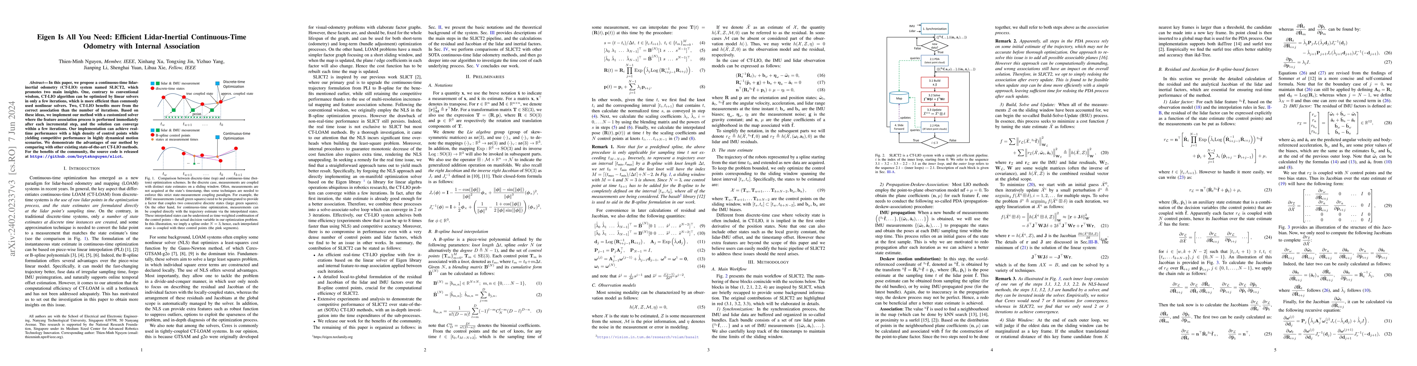
In this paper, we propose a continuous-time lidar-inertial odometry (CT-LIO) system named SLICT2, which promotes two main insights. One, contrary to conventional wisdom, CT-LIO algorithm can be opti...
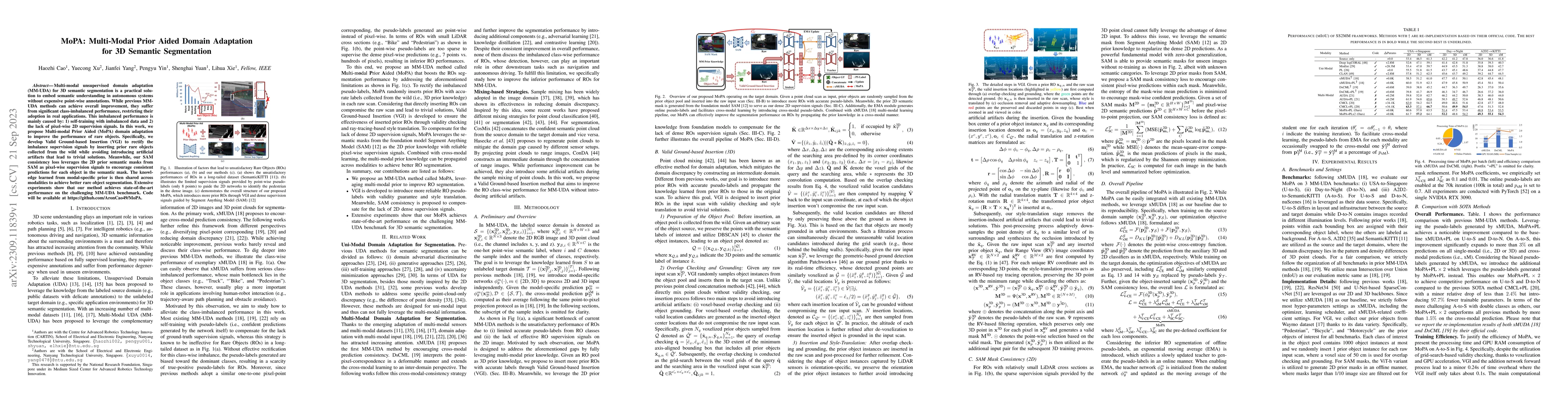
Multi-modal unsupervised domain adaptation (MM-UDA) for 3D semantic segmentation is a practical solution to embed semantic understanding in autonomous systems without expensive point-wise annotation...
One-shot LiDAR localization refers to the ability to estimate the robot pose from one single point cloud, which yields significant advantages in initialization and relocalization processes. In the p...
This letter presents an accurate and robust Lidar Inertial Odometry framework. We fuse LiDAR scans with IMU data using a tightly-coupled iterative error state Kalman filter for robust and fast local...
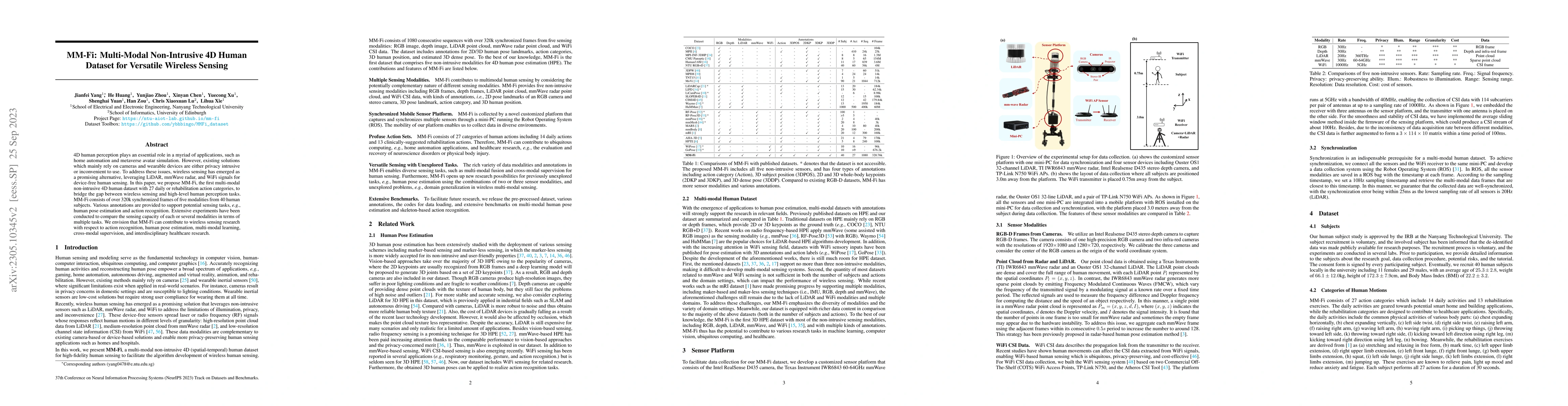
4D human perception plays an essential role in a myriad of applications, such as home automation and metaverse avatar simulation. However, existing solutions which mainly rely on cameras and wearabl...
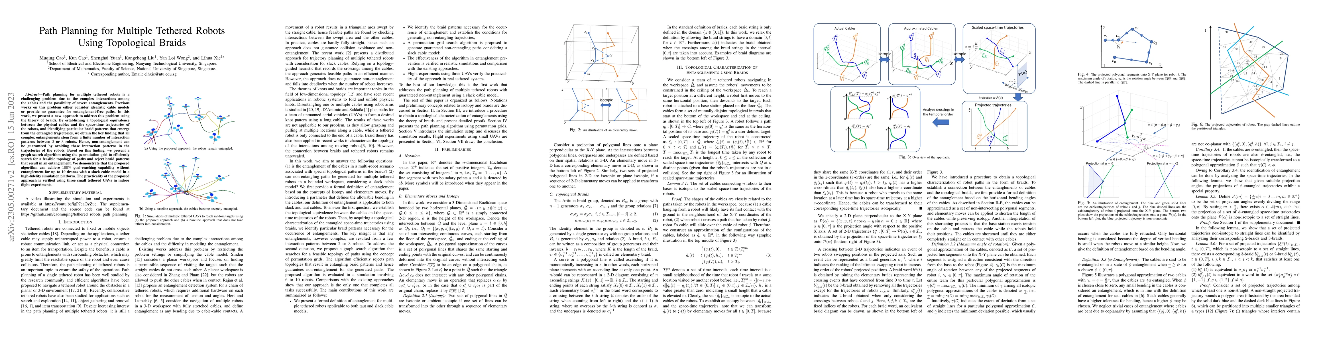
Path planning for multiple tethered robots is a challenging problem due to the complex interactions among the cables and the possibility of severe entanglements. Previous works on this problem eithe...
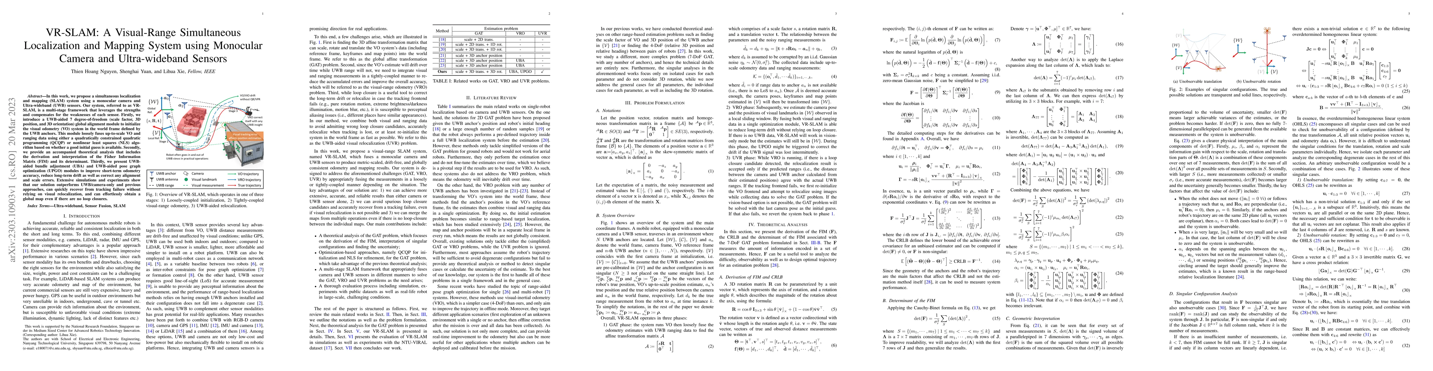
In this work, we propose a simultaneous localization and mapping (SLAM) system using a monocular camera and Ultra-wideband (UWB) sensors. Our system, referred to as VRSLAM, is a multi-stage framewor...
Continual Test-Time Adaptation (CTTA) generalizes conventional Test-Time Adaptation (TTA) by assuming that the target domain is dynamic over time rather than stationary. In this paper, we explore Mu...
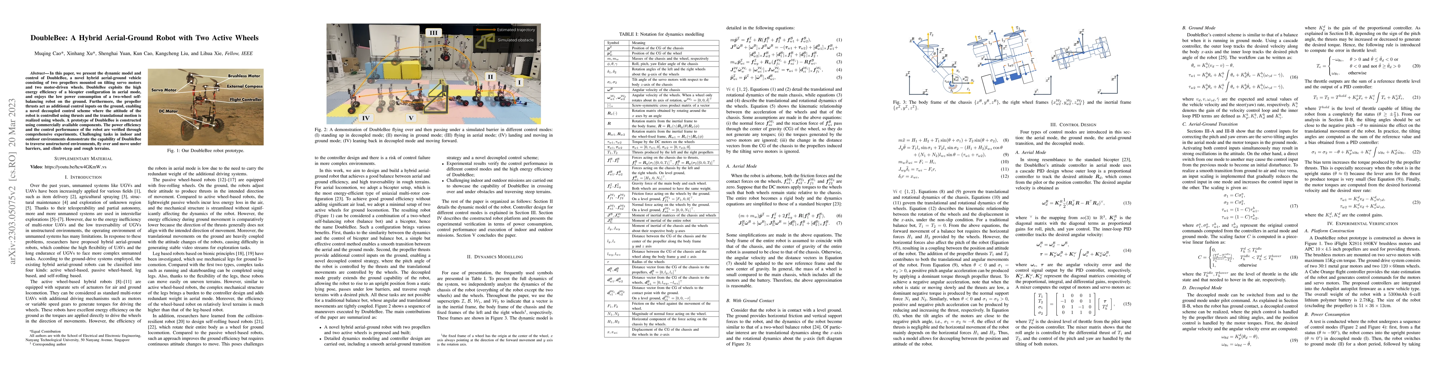
We present the dynamic model and control of DoubleBee, a novel hybrid aerial-ground vehicle consisting of two propellers mounted on tilting servo motors and two motor-driven wheels. DoubleBee exploi...
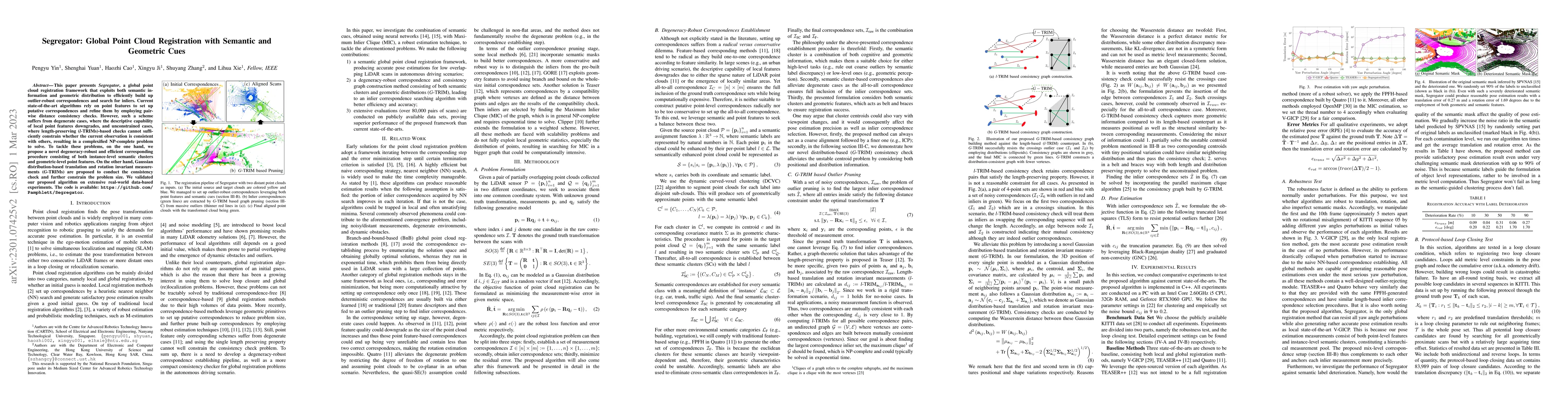
This paper presents Segregator, a global point cloud registration framework that exploits both semantic information and geometric distribution to efficiently build up outlier-robust correspondences ...
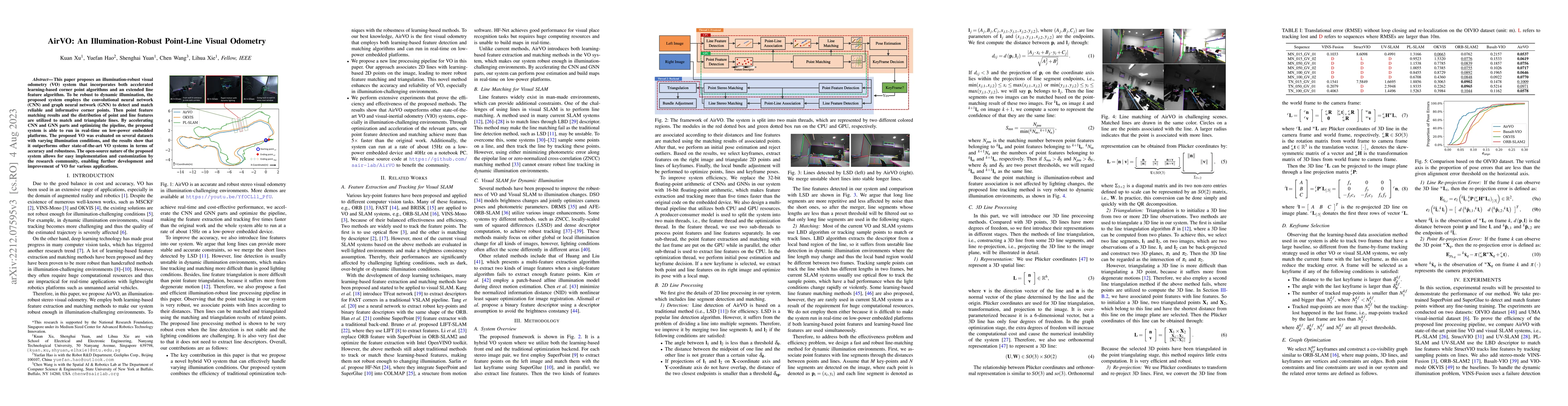
This paper proposes an illumination-robust visual odometry (VO) system that incorporates both accelerated learning-based corner point algorithms and an extended line feature algorithm. To be robust ...
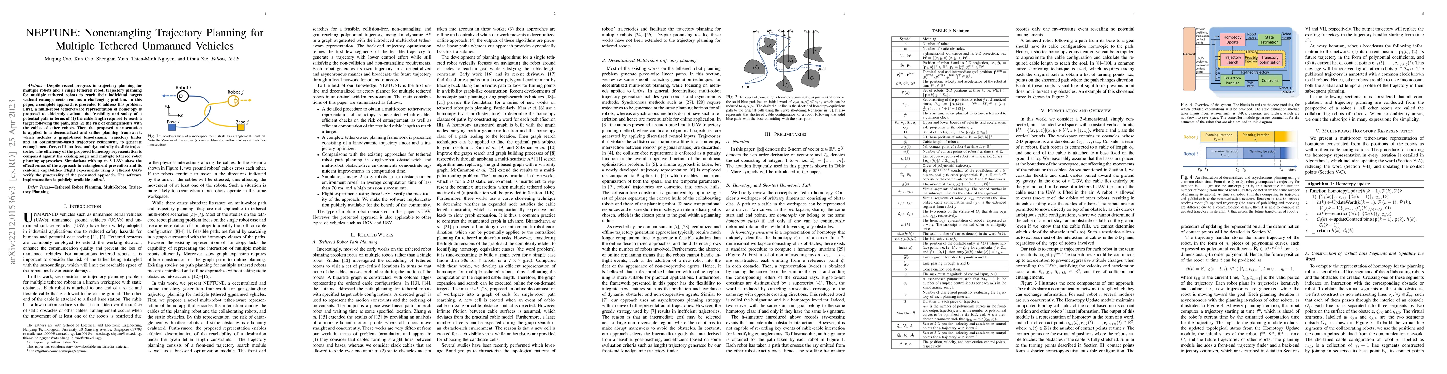
Despite recent progress on trajectory planning of multiple robots and path planning of a single tethered robot, planning of multiple tethered robots to reach their individual targets without entangl...
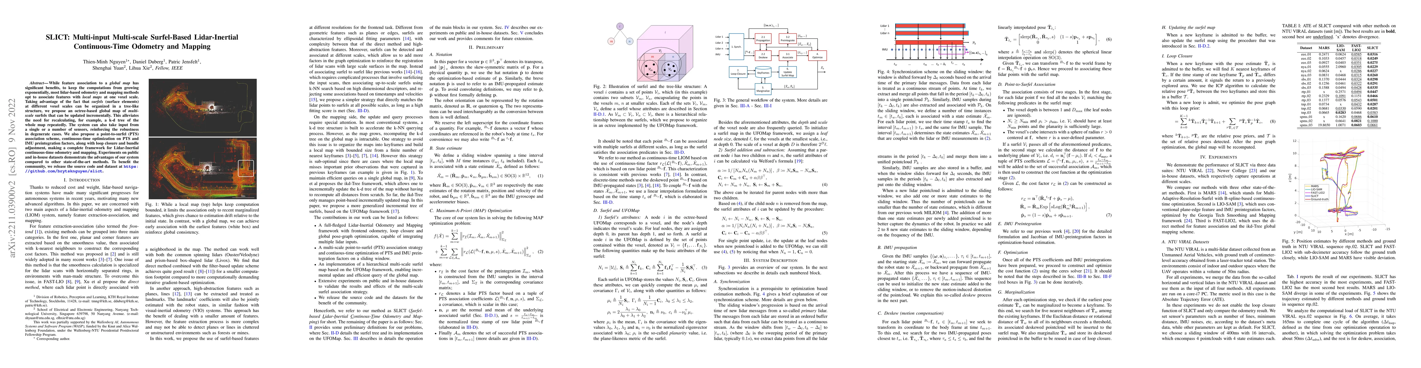
While feature association to a global map has significant benefits, to keep the computations from growing exponentially, most lidar-based odometry and mapping methods opt to associate features with ...
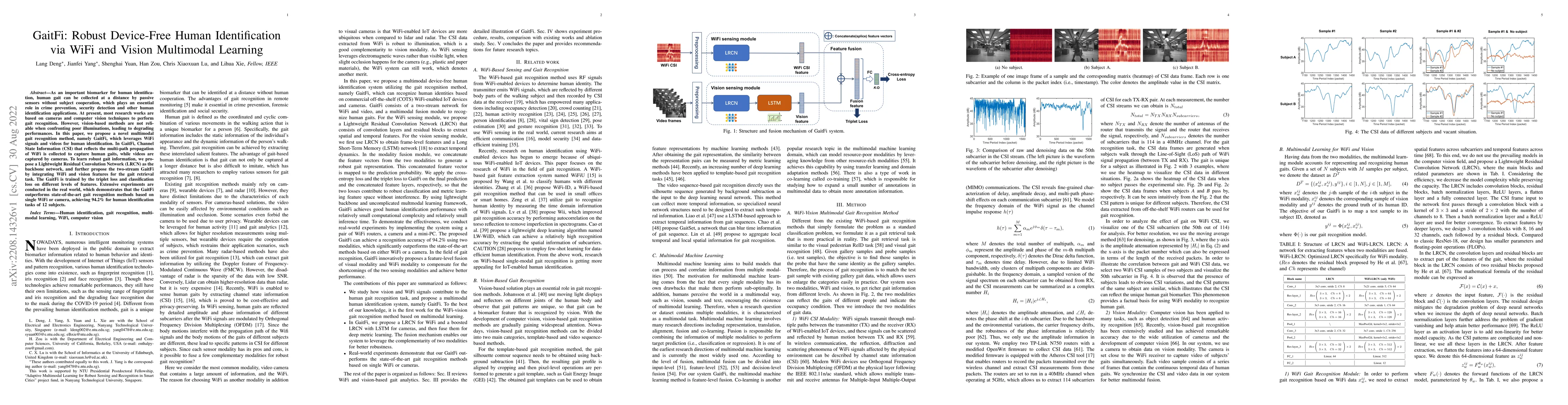
As an important biomarker for human identification, human gait can be collected at a distance by passive sensors without subject cooperation, which plays an essential role in crime prevention, secur...
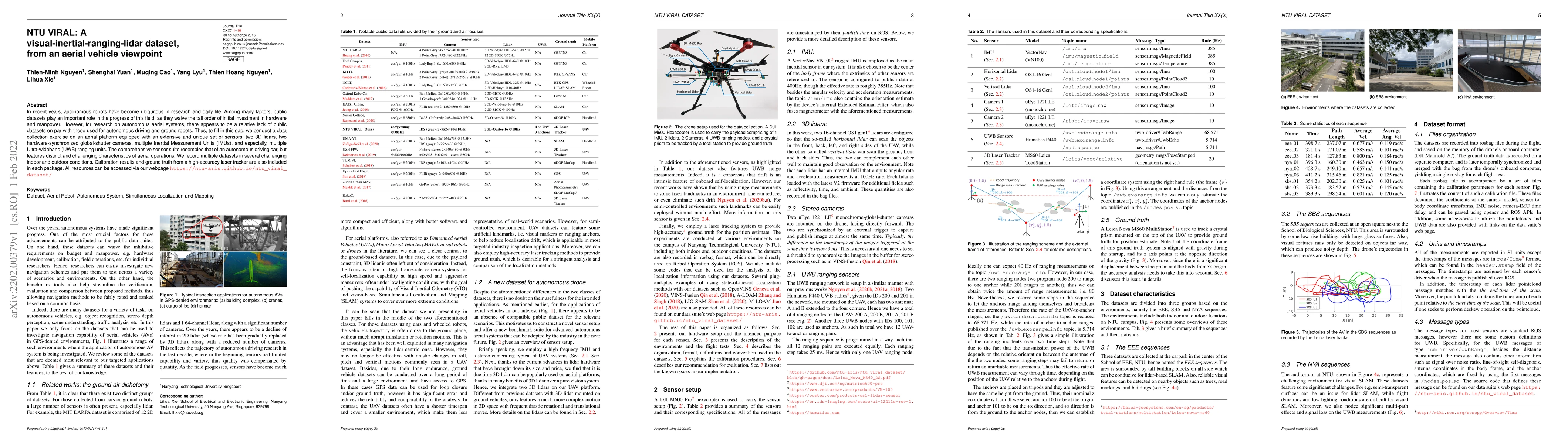
In recent years, autonomous robots have become ubiquitous in research and daily life. Among many factors, public datasets play an important role in the progress of this field, as they waive the tall...
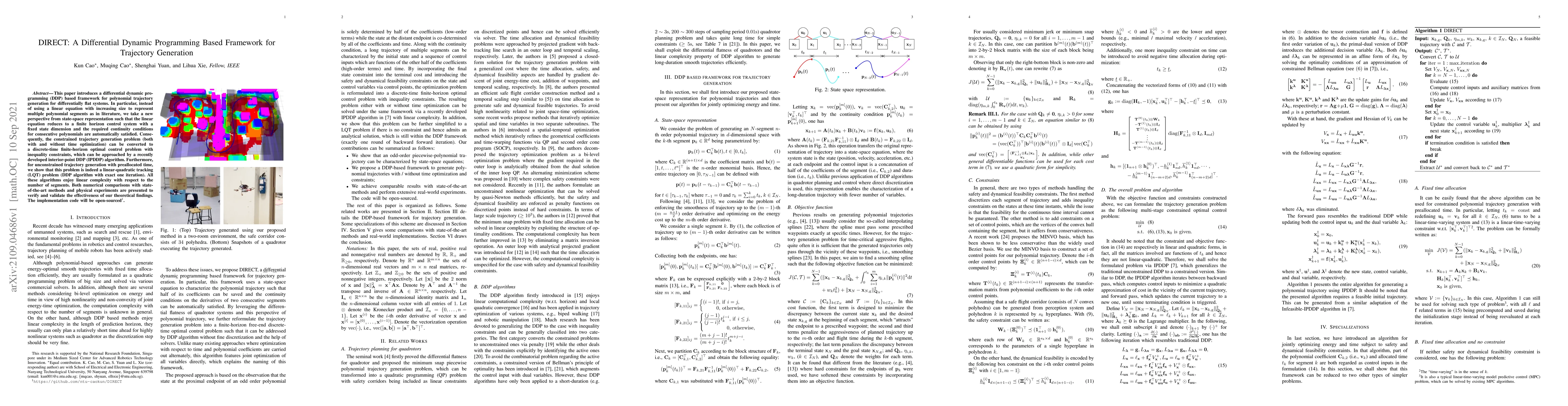
This paper introduces a differential dynamic programming (DDP) based framework for polynomial trajectory generation for differentially flat systems. In particular, instead of using a linear equation...
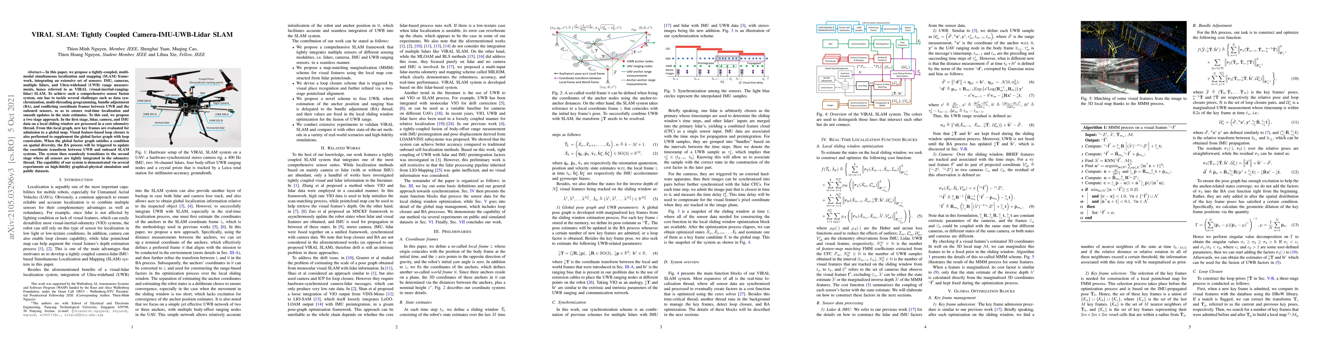
In this paper, we propose a tightly-coupled, multi-modal simultaneous localization and mapping (SLAM) framework, integrating an extensive set of sensors: IMU, cameras, multiple lidars, and Ultra-wid...
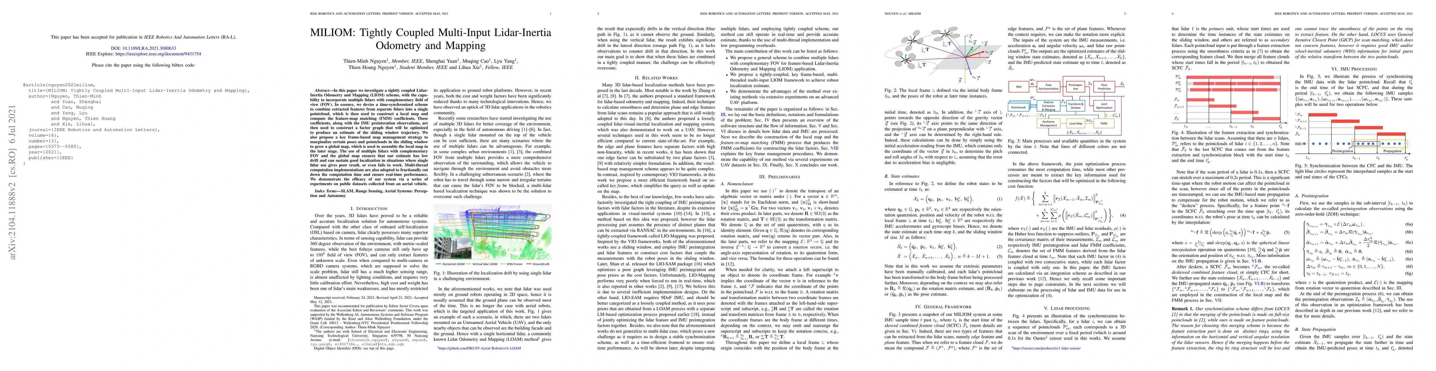
In this letter we investigate a tightly coupled Lidar-Inertia Odometry and Mapping (LIOM) scheme, with the capability to incorporate multiple lidars with complementary field of view (FOV). In essenc...
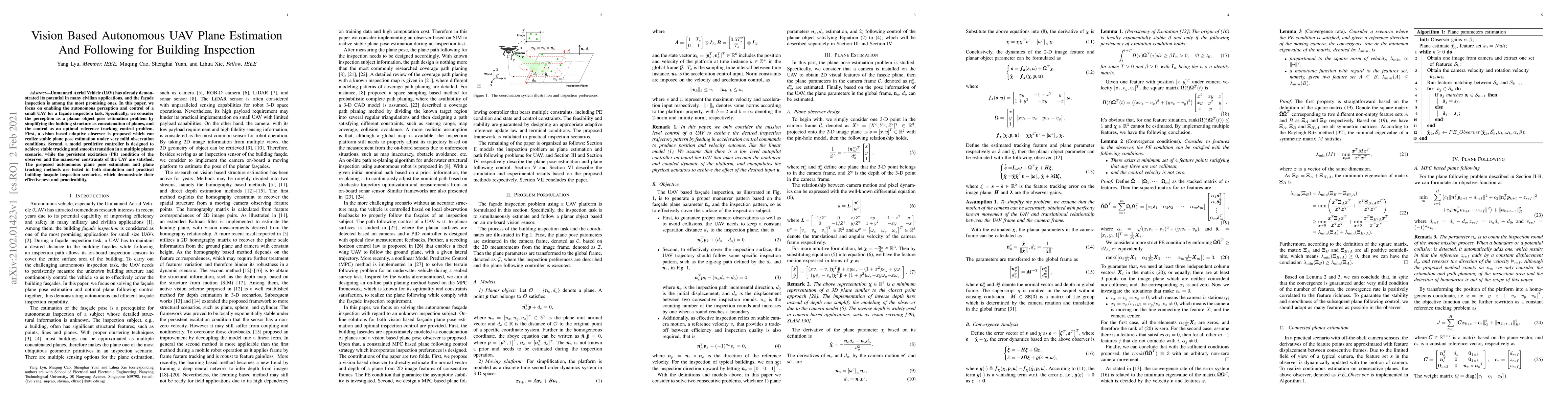
Unmanned Aerial Vehicle (UAV) has already demonstrated its potential in many civilian applications, and the fa\c{c}ade inspection is among the most promising ones. In this paper, we focus on enablin...
Although Simultaneous Localization and Mapping (SLAM) has been an active research topic for decades, current state-of-the-art methods still suffer from instability or inaccuracy due to feature insuf...
In recent years, thanks to the continuously reduced cost and weight of 3D Lidar, the applications of this type of sensor in robotics community have become increasingly popular. Despite many progress...
In recent years, Onboard Self Localization (OSL) methods based on cameras or Lidar have achieved many significant progresses. However, some issues such as estimation drift and feature-dependence sti...
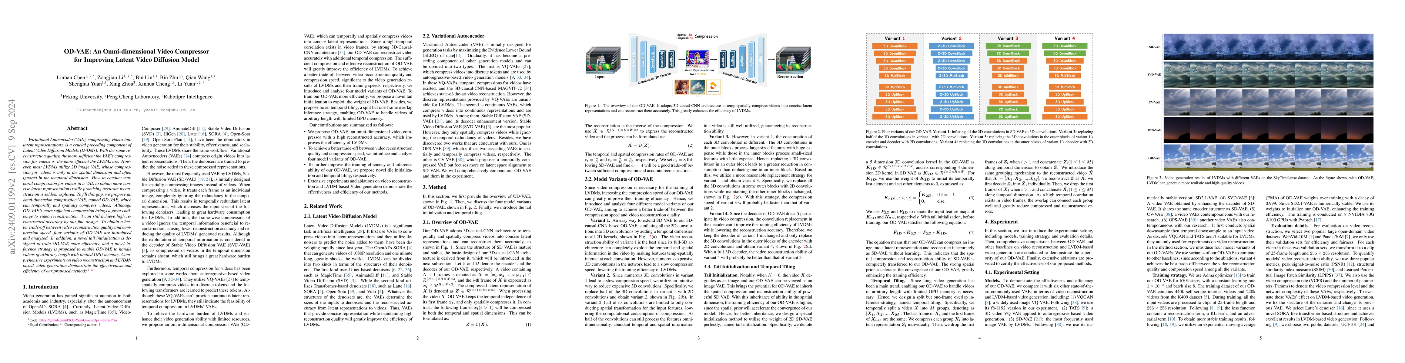
Variational Autoencoder (VAE), compressing videos into latent representations, is a crucial preceding component of Latent Video Diffusion Models (LVDMs). With the same reconstruction quality, the more...
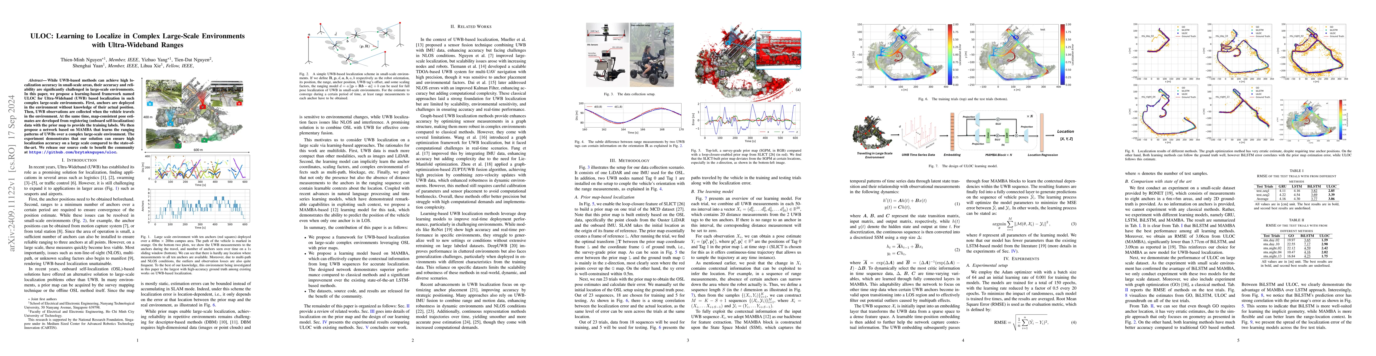
While UWB-based methods can achieve high localization accuracy in small-scale areas, their accuracy and reliability are significantly challenged in large-scale environments. In this paper, we propose ...
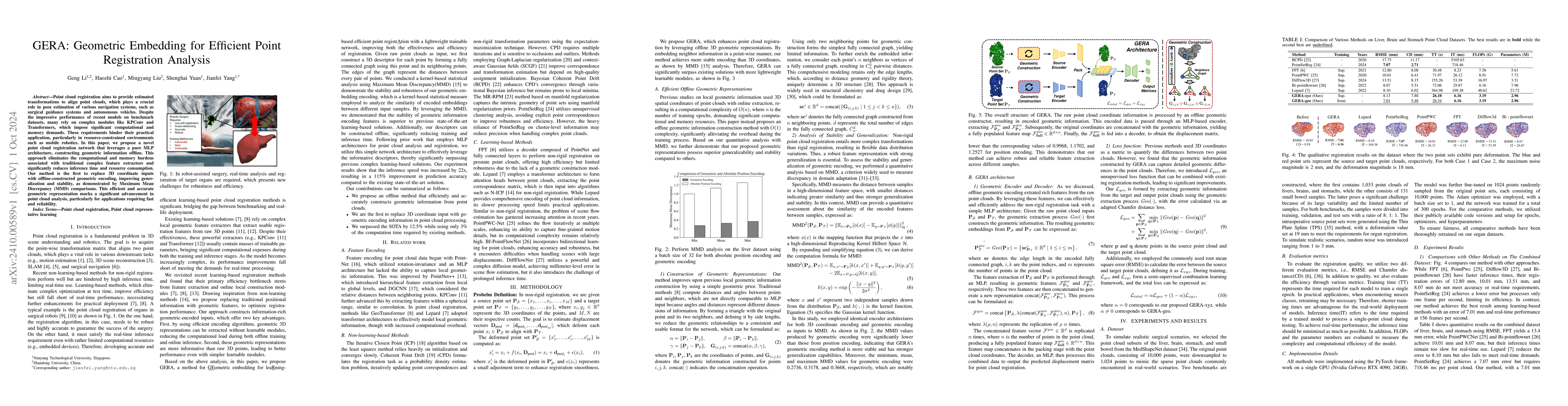
Point cloud registration aims to provide estimated transformations to align point clouds, which plays a crucial role in pose estimation of various navigation systems, such as surgical guidance systems...
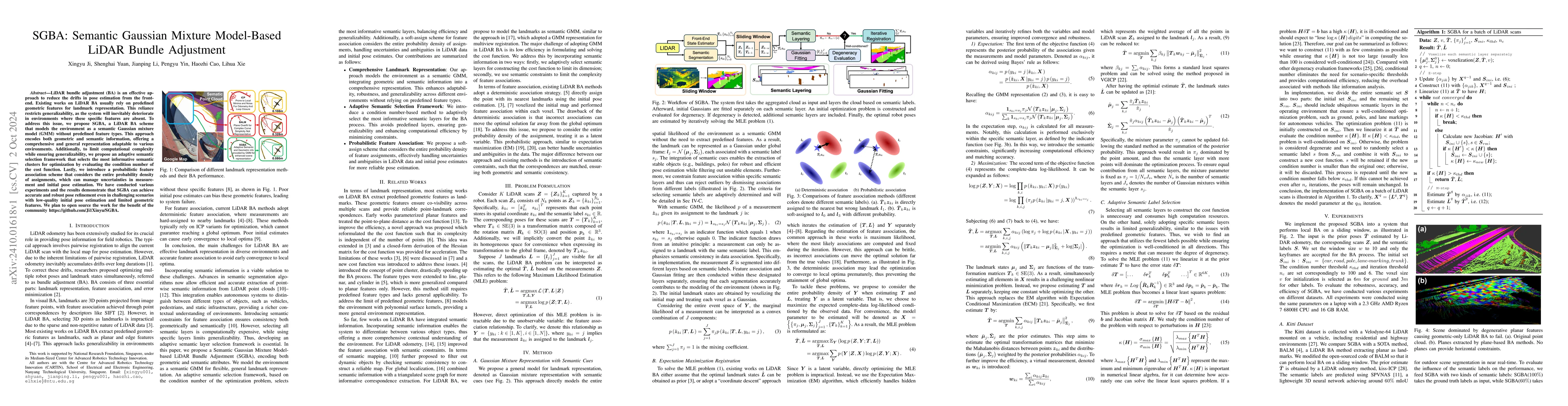
LiDAR bundle adjustment (BA) is an effective approach to reduce the drifts in pose estimation from the front-end. Existing works on LiDAR BA usually rely on predefined geometric features for landmark ...
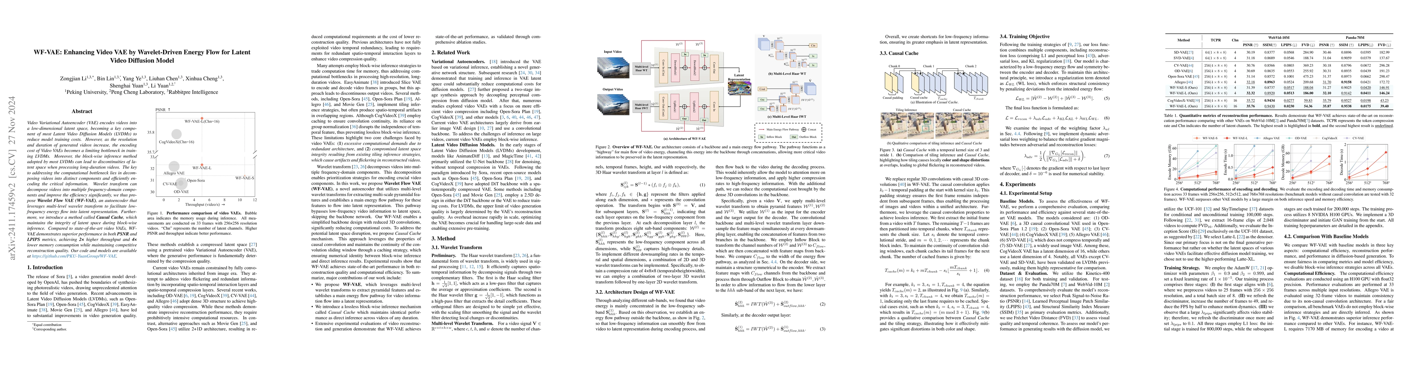
Video Variational Autoencoder (VAE) encodes videos into a low-dimensional latent space, becoming a key component of most Latent Video Diffusion Models (LVDMs) to reduce model training costs. However, ...
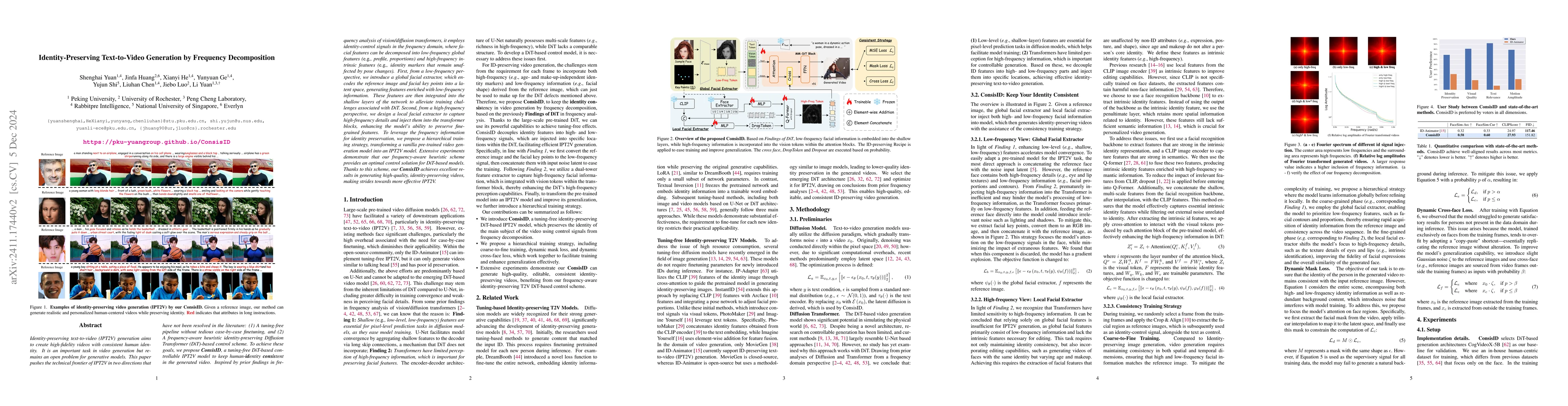
Identity-preserving text-to-video (IPT2V) generation aims to create high-fidelity videos with consistent human identity. It is an important task in video generation but remains an open problem for gen...
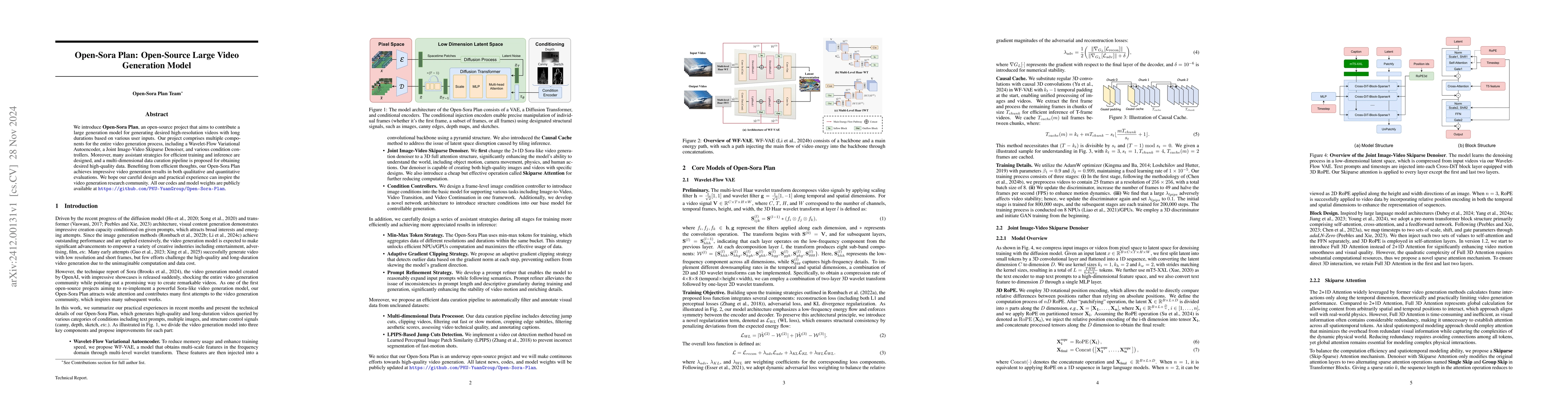
We introduce Open-Sora Plan, an open-source project that aims to contribute a large generation model for generating desired high-resolution videos with long durations based on various user inputs. Our...
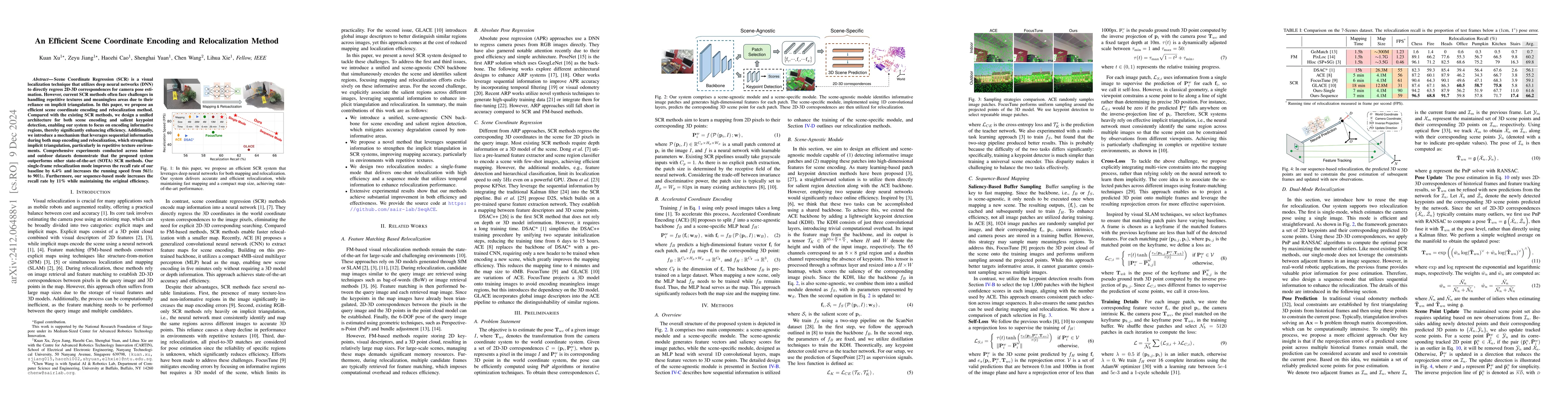
Scene Coordinate Regression (SCR) is a visual localization technique that utilizes deep neural networks (DNN) to directly regress 2D-3D correspondences for camera pose estimation. However, current SCR...
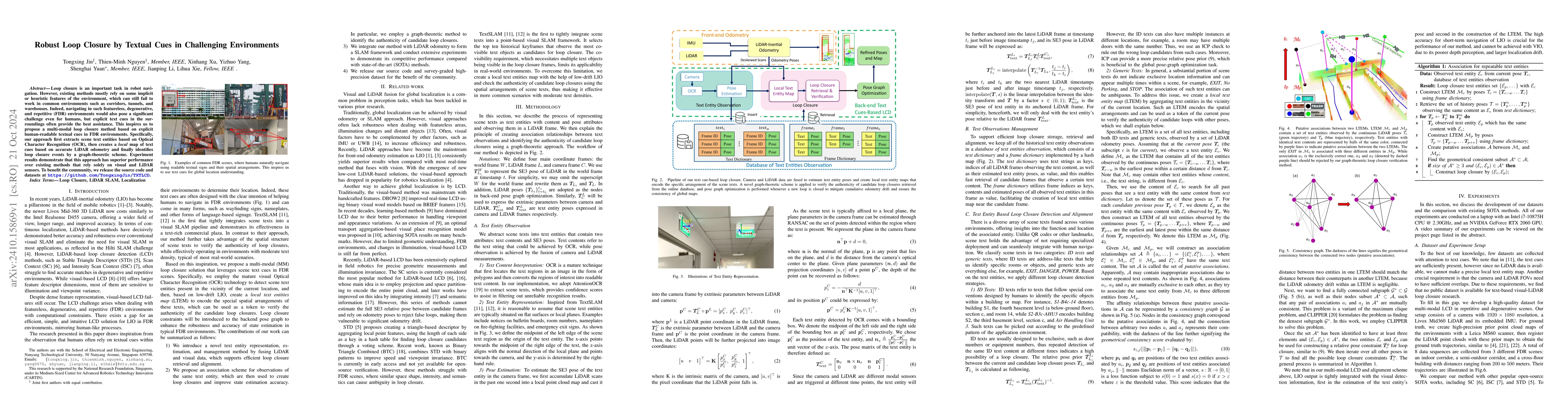
Loop closure is an important task in robot navigation. However, existing methods mostly rely on some implicit or heuristic features of the environment, which can still fail to work in common environme...
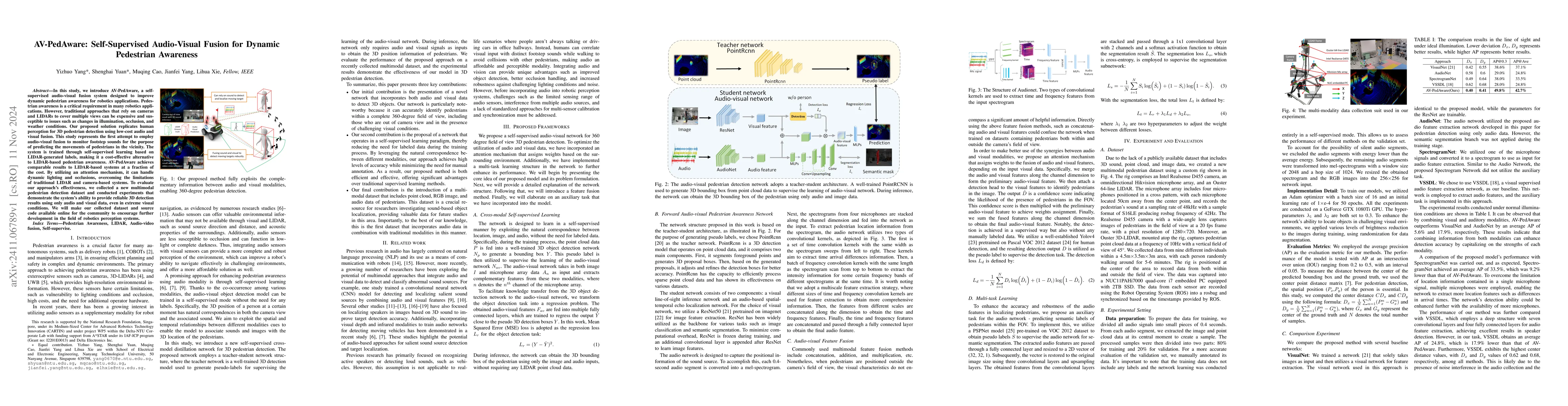
In this study, we introduce AV-PedAware, a self-supervised audio-visual fusion system designed to improve dynamic pedestrian awareness for robotics applications. Pedestrian awareness is a critical req...
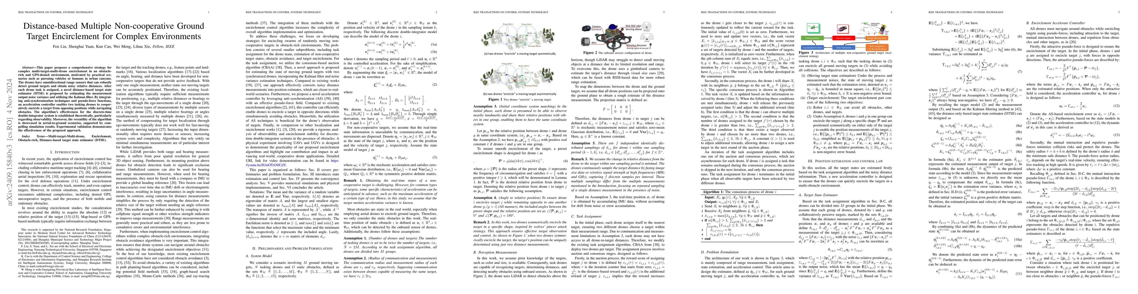
This paper proposes a comprehensive strategy for complex multi-target-multi-drone encirclement in an obstacle-rich and GPS-denied environment, motivated by practical scenarios such as pursuing vehicle...
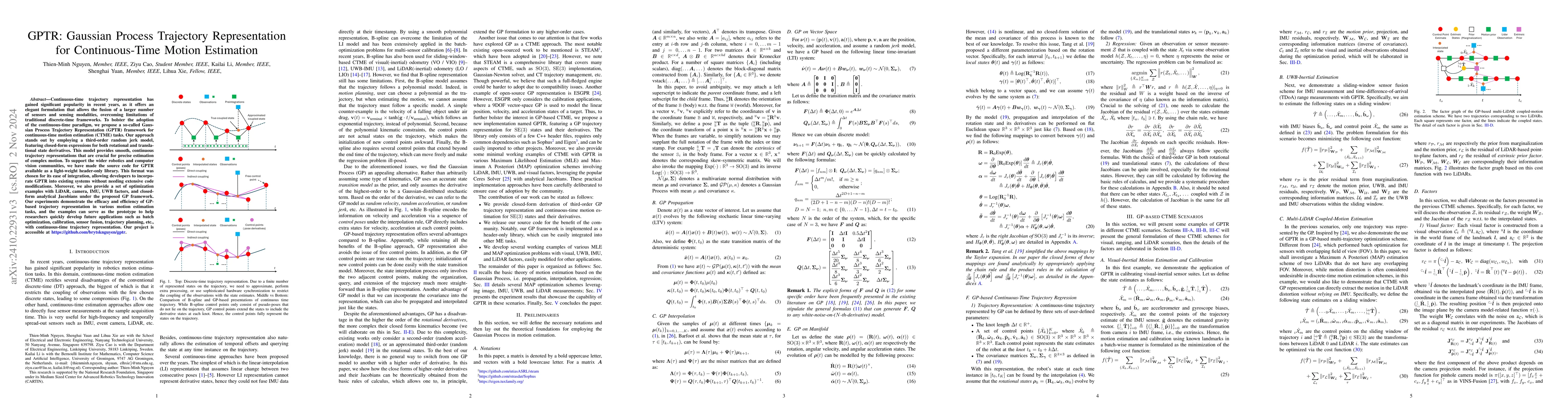
Continuous-time trajectory representation has gained significant popularity in recent years, as it offers an elegant formulation that allows the fusion of a larger number of sensors and sensing modali...
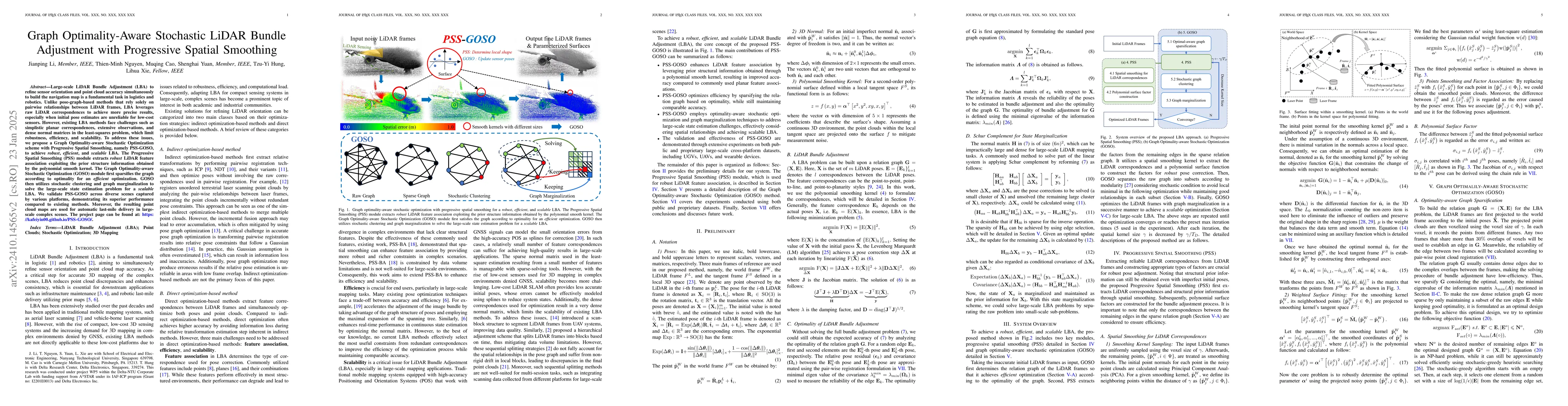
Large-scale LiDAR Bundle Adjustment (LBA) for refining sensor orientation and point cloud accuracy simultaneously is a fundamental task in photogrammetry and robotics, particularly as low-cost 3D sens...
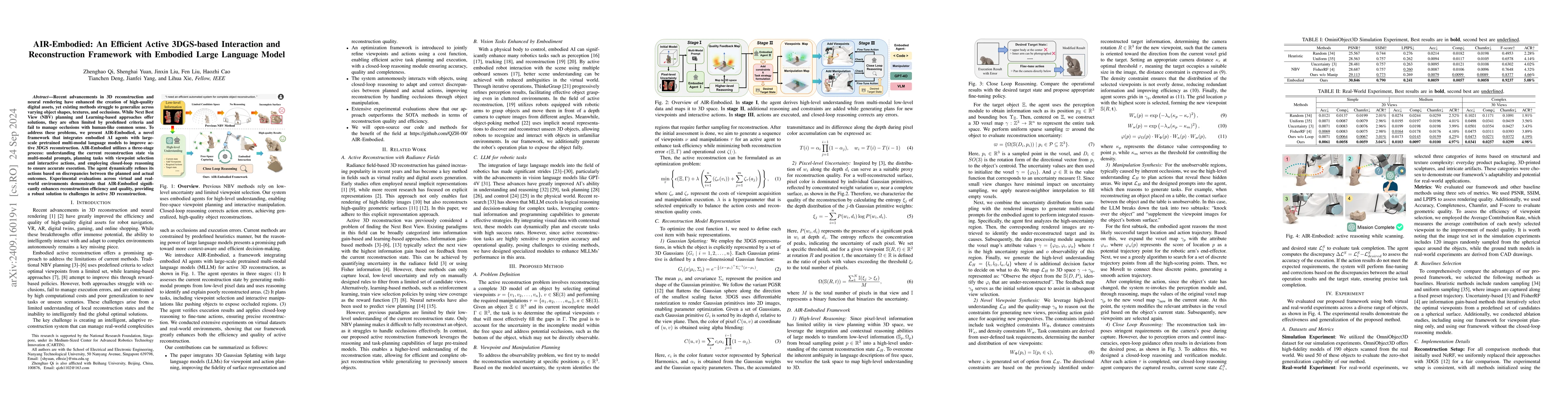
Recent advancements in 3D reconstruction and neural rendering have enhanced the creation of high-quality digital assets, yet existing methods struggle to generalize across varying object shapes, textu...
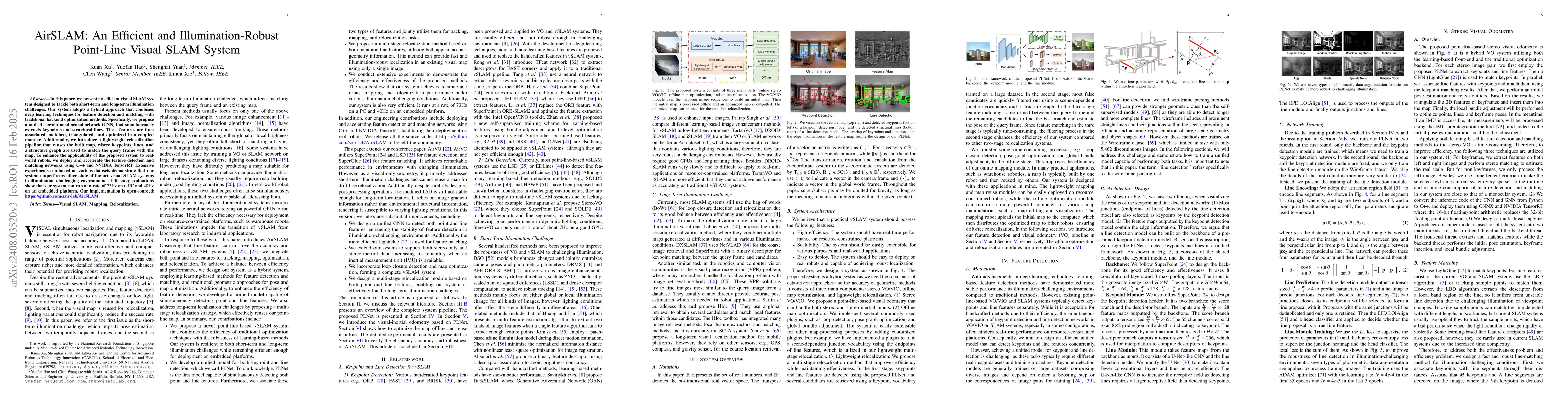
In this paper, we present an efficient visual SLAM system designed to tackle both short-term and long-term illumination challenges. Our system adopts a hybrid approach that combines deep learning tech...
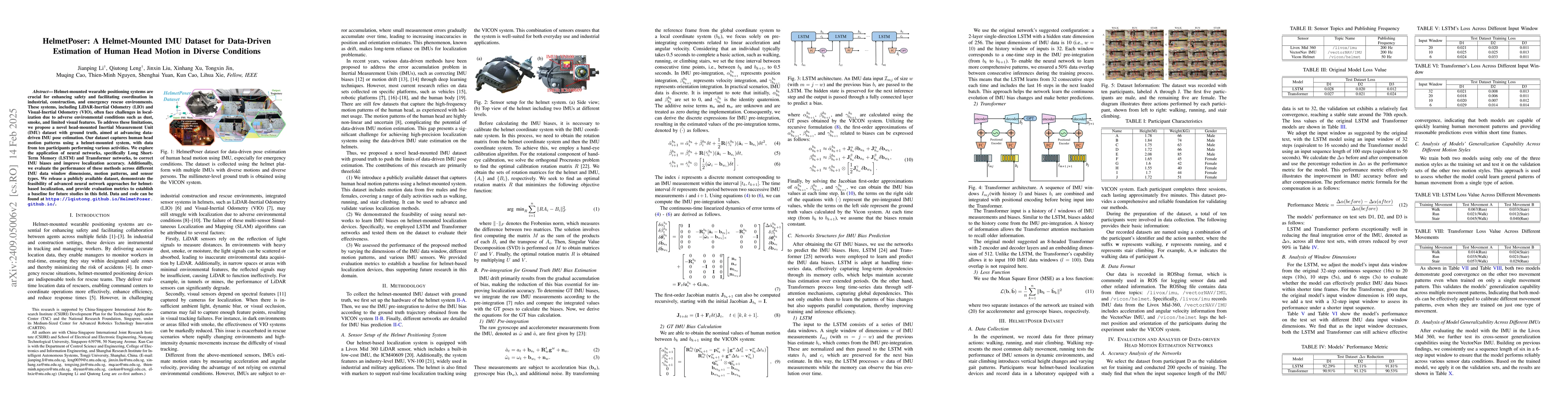
Helmet-mounted wearable positioning systems are crucial for enhancing safety and facilitating coordination in industrial, construction, and emergency rescue environments. These systems, including LiDA...
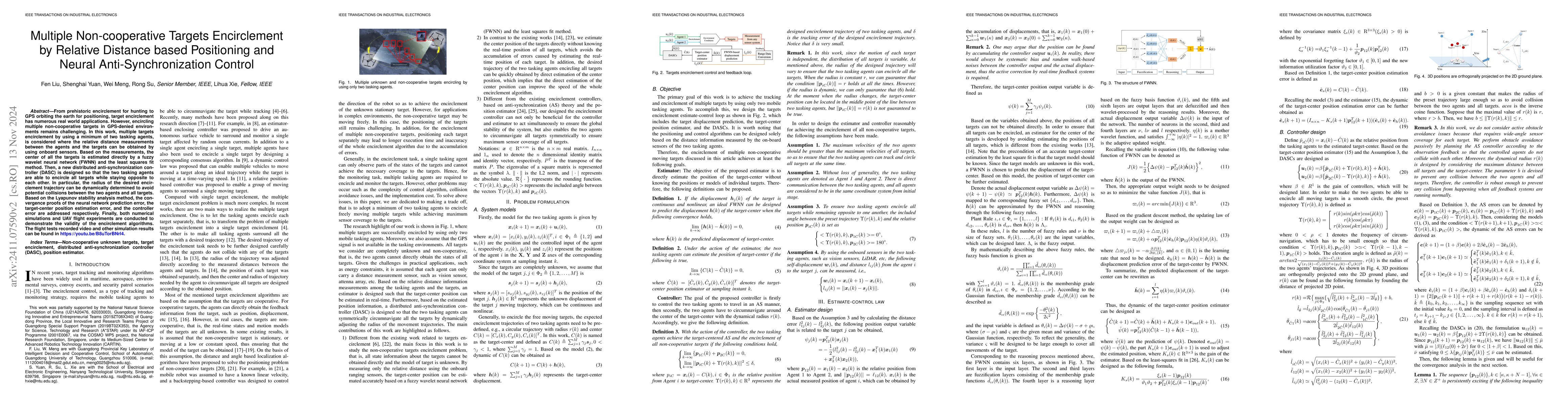
From prehistoric encirclement for hunting to GPS orbiting the earth for positioning, target encirclement has numerous real world applications. However, encircling multiple non-cooperative targets in G...
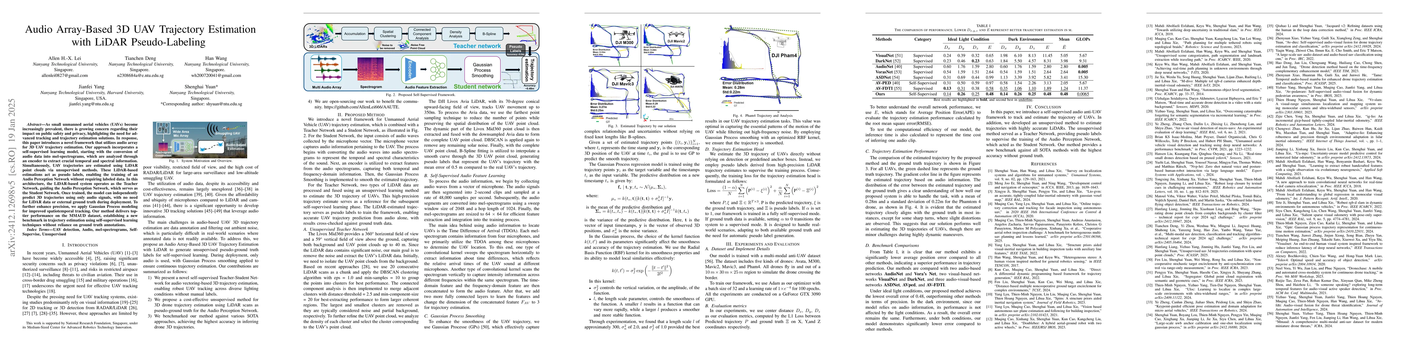
As small unmanned aerial vehicles (UAVs) become increasingly prevalent, there is growing concern regarding their impact on public safety and privacy, highlighting the need for advanced tracking and tr...
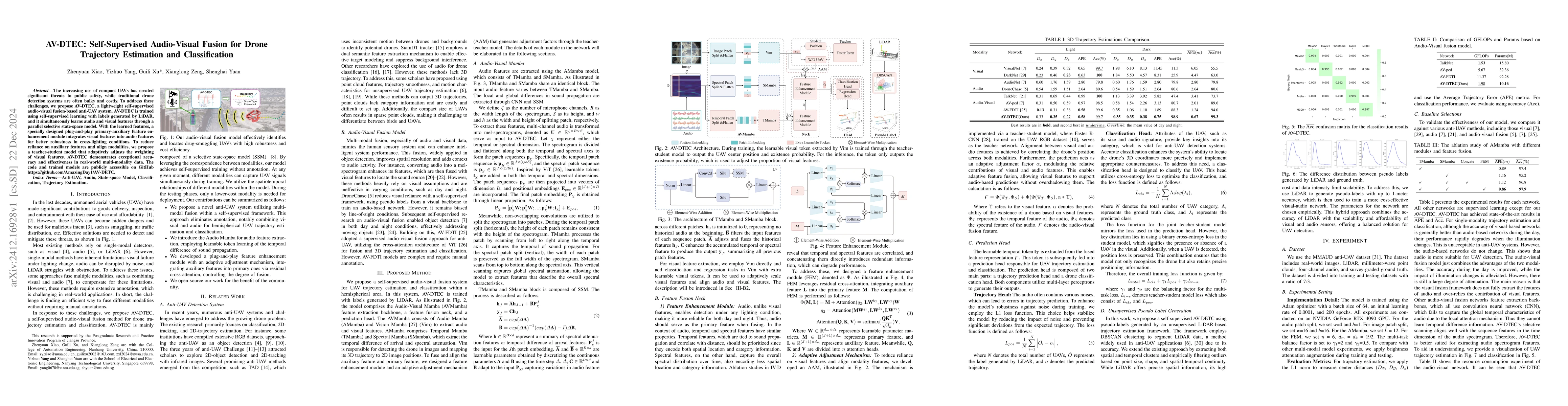
The increasing use of compact UAVs has created significant threats to public safety, while traditional drone detection systems are often bulky and costly. To address these challenges, we propose AV-DT...
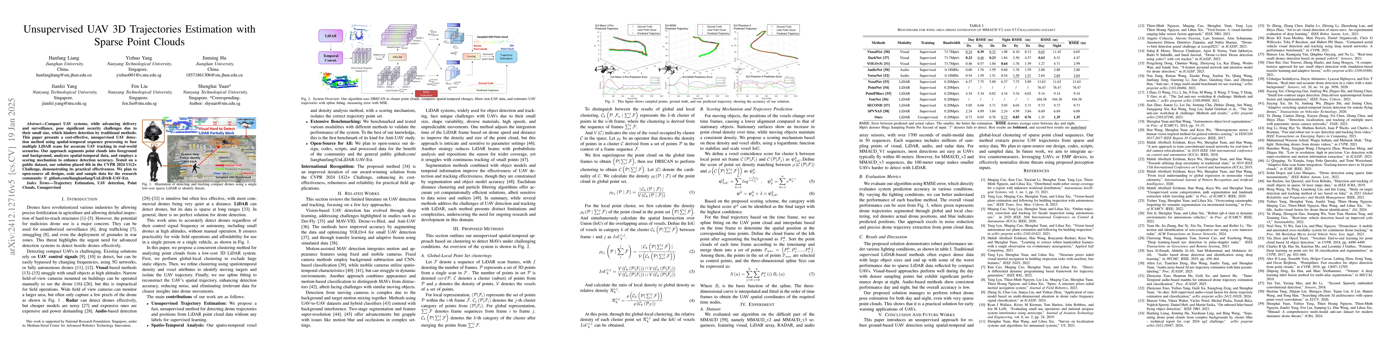
Compact UAV systems, while advancing delivery and surveillance, pose significant security challenges due to their small size, which hinders detection by traditional methods. This paper presents a cost...
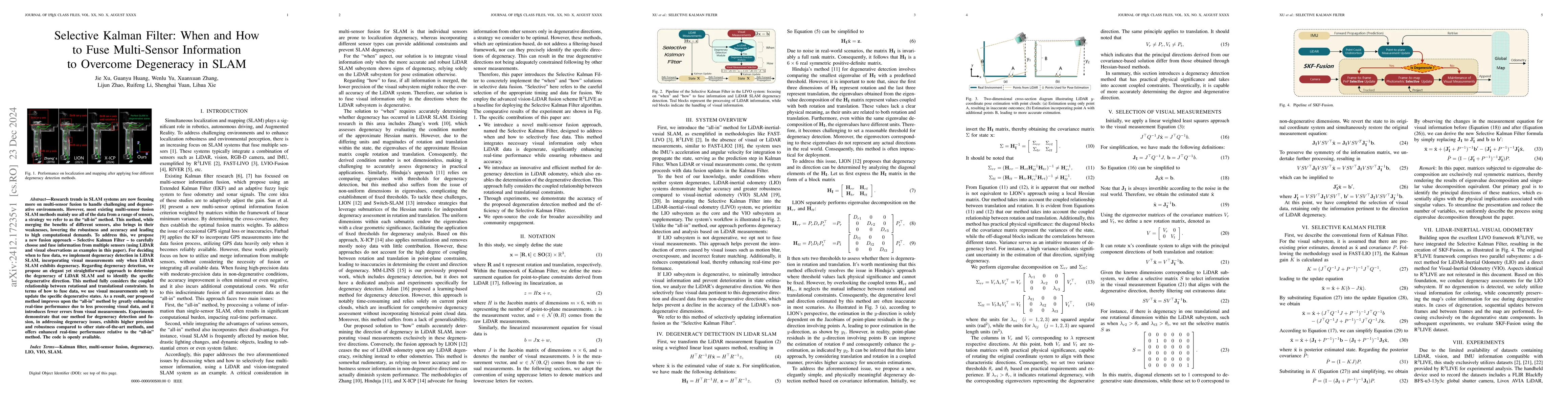
Research trends in SLAM systems are now focusing more on multi-sensor fusion to handle challenging and degenerative environments. However, most existing multi-sensor fusion SLAM methods mainly use all...
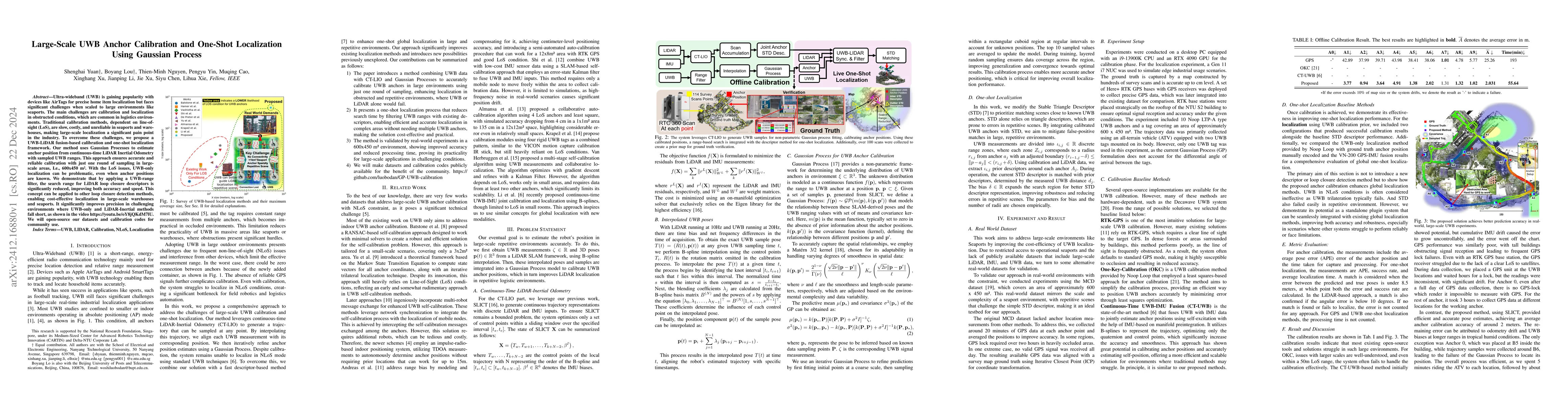
Ultra-wideband (UWB) is gaining popularity with devices like AirTags for precise home item localization but faces significant challenges when scaled to large environments like seaports. The main chall...
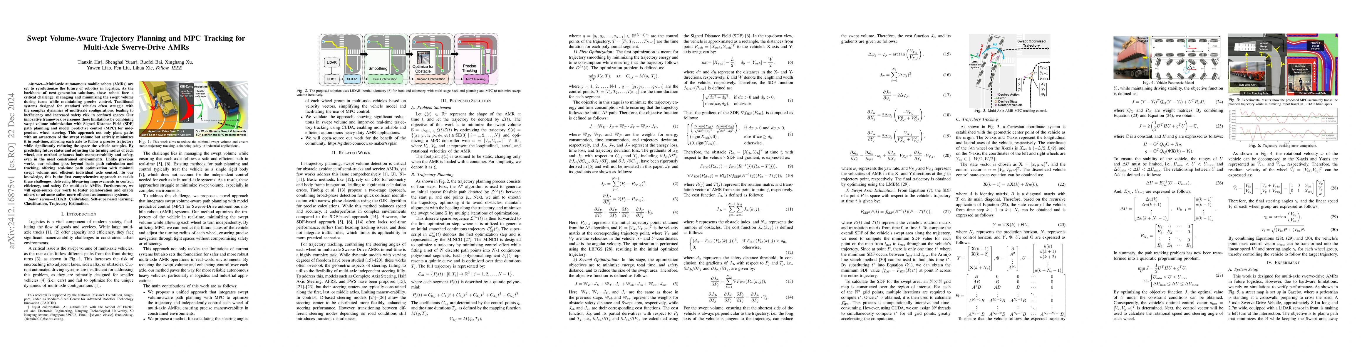
Multi-axle autonomous mobile robots (AMRs) are set to revolutionize the future of robotics in logistics. As the backbone of next-generation solutions, these robots face a critical challenge: managing ...
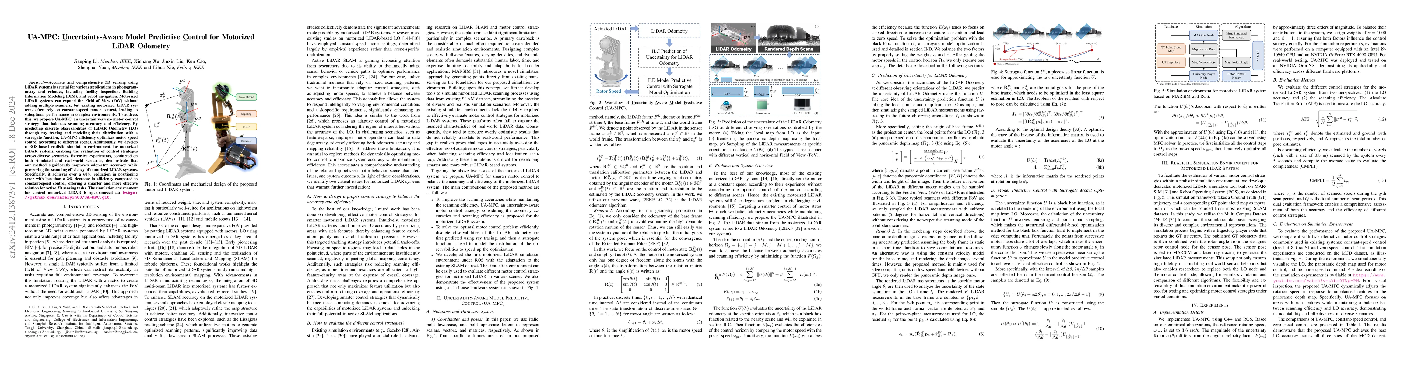
Accurate and comprehensive 3D sensing using LiDAR systems is crucial for various applications in photogrammetry and robotics, including facility inspection, Building Information Modeling (BIM), and ro...
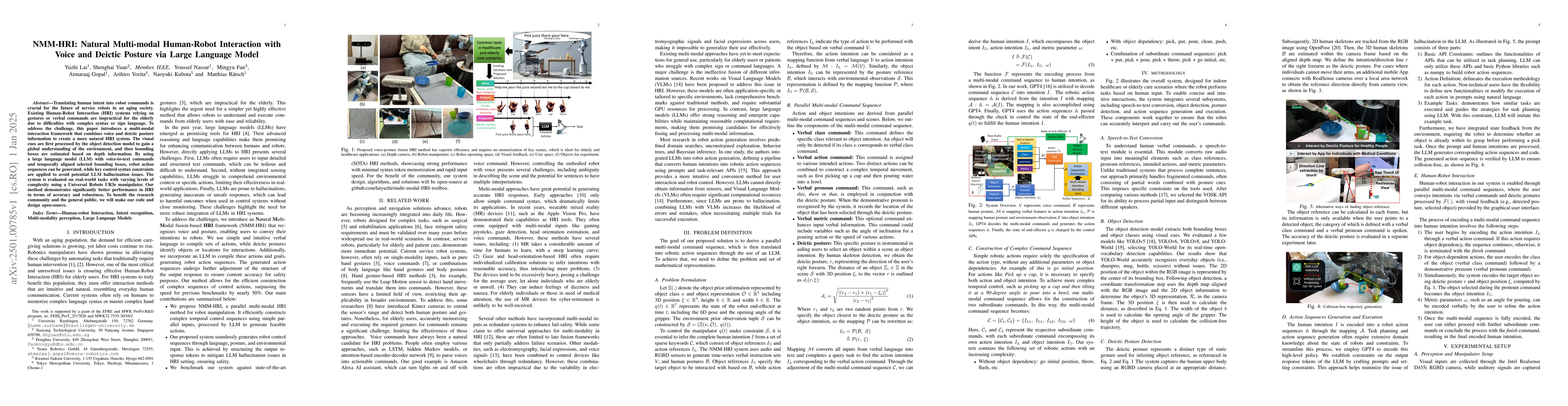
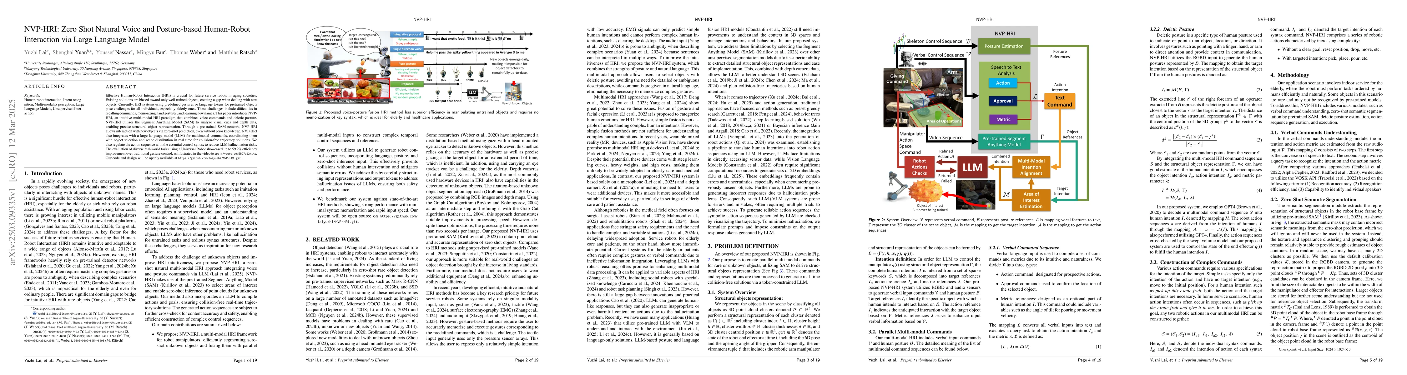
Translating human intent into robot commands is crucial for the future of service robots in an aging society. Existing Human-Robot Interaction (HRI) systems relying on gestures or verbal commands are ...
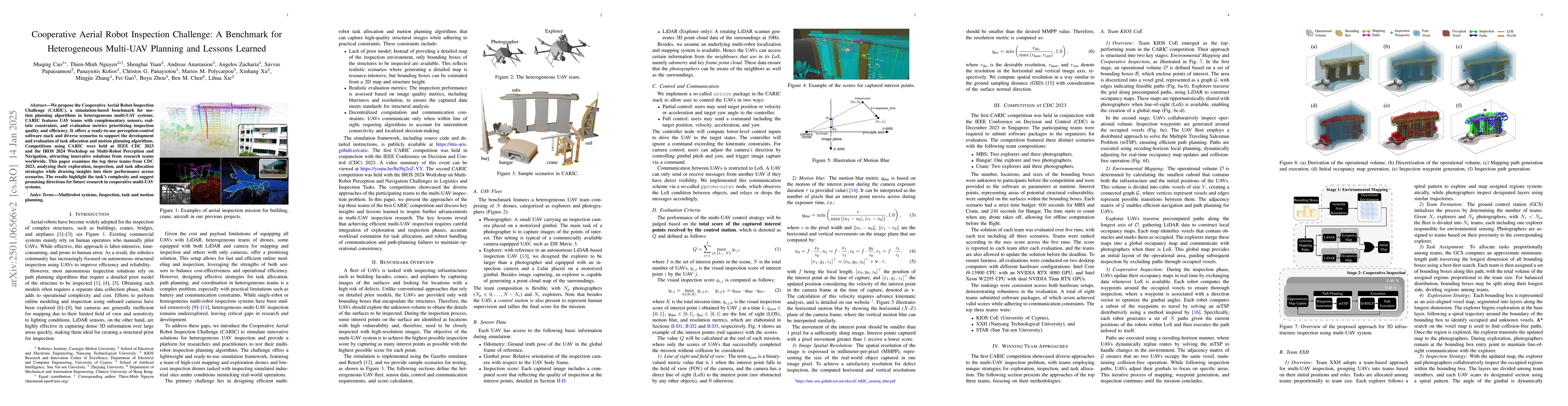
We propose the Cooperative Aerial Robot Inspection Challenge (CARIC), a simulation-based benchmark for motion planning algorithms in heterogeneous multi-UAV systems. CARIC features UAV teams with comp...
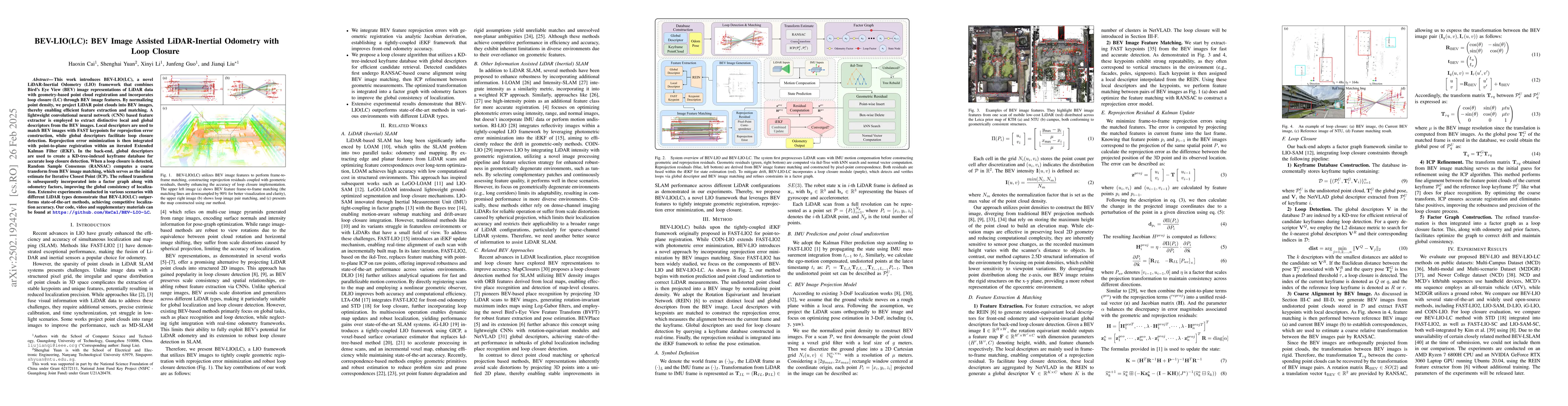
This work introduces BEV-LIO(LC), a novel LiDAR-Inertial Odometry (LIO) framework that combines Bird's Eye View (BEV) image representations of LiDAR data with geometry-based point cloud registration a...
Conventional single LiDAR systems are inherently constrained by their limited field of view (FoV), leading to blind spots and incomplete environmental awareness, particularly on robotic platforms with...
Multi-robot navigation in complex environments relies on inter-robot communication and mutual observations for coordination and situational awareness. This paper studies the multi-robot navigation pro...
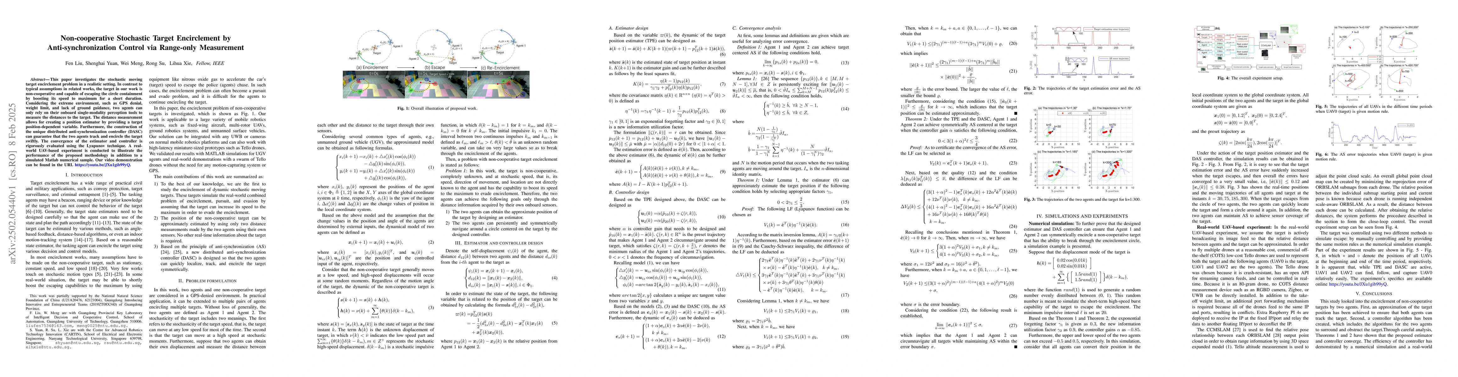
This paper investigates the stochastic moving target encirclement problem in a realistic setting. In contrast to typical assumptions in related works, the target in our work is non-cooperative and cap...
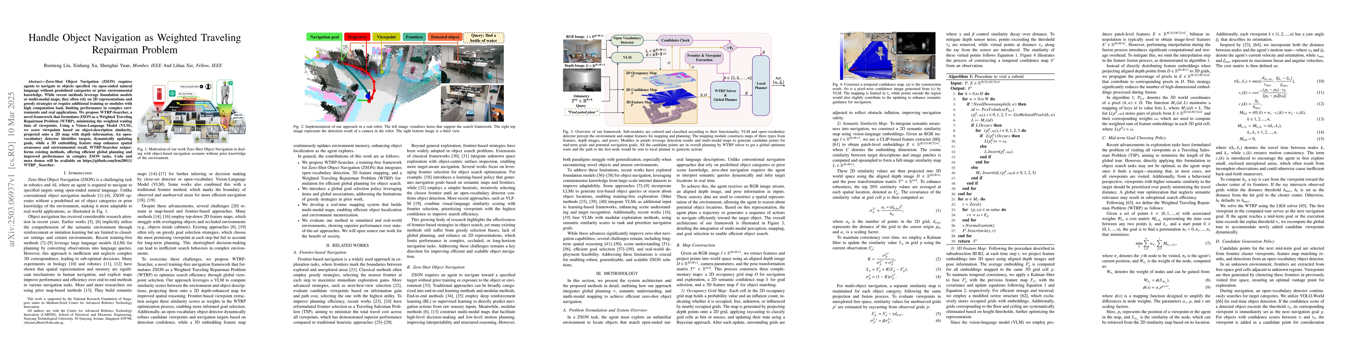
Zero-Shot Object Navigation (ZSON) requires agents to navigate to objects specified via open-ended natural language without predefined categories or prior environmental knowledge. While recent methods...
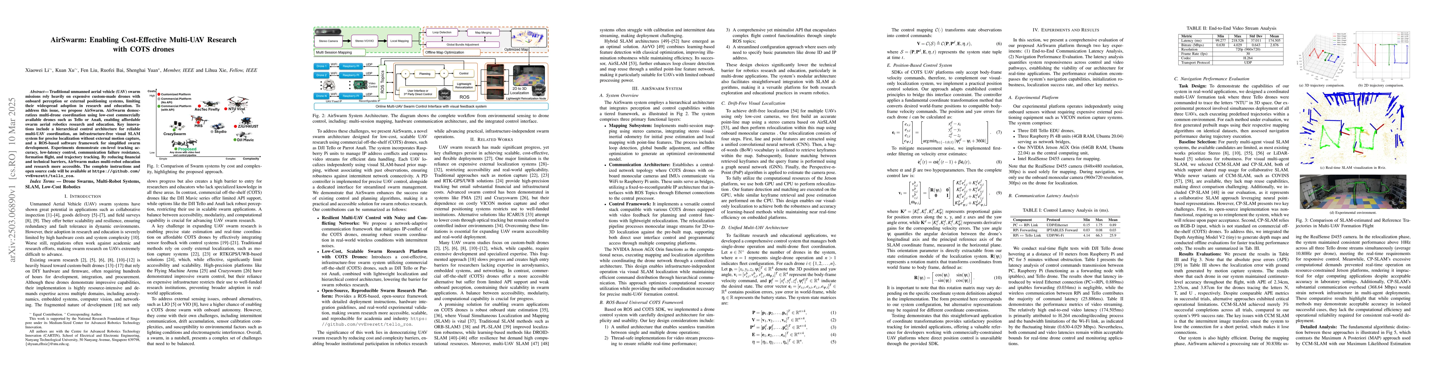
Traditional unmanned aerial vehicle (UAV) swarm missions rely heavily on expensive custom-made drones with onboard perception or external positioning systems, limiting their widespread adoption in res...
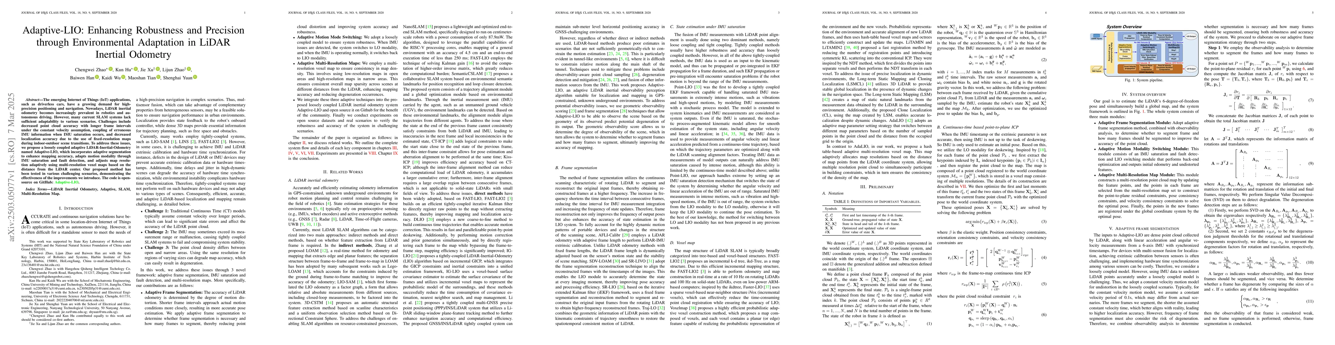
The emerging Internet of Things (IoT) applications, such as driverless cars, have a growing demand for high-precision positioning and navigation. Nowadays, LiDAR inertial odometry becomes increasingly...
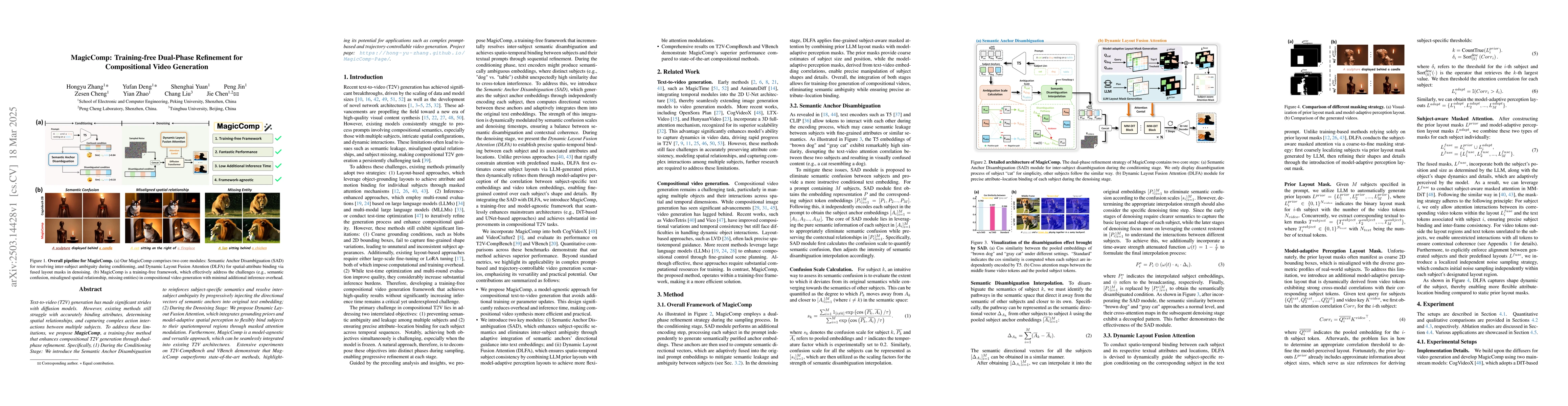
Text-to-video (T2V) generation has made significant strides with diffusion models. However, existing methods still struggle with accurately binding attributes, determining spatial relationships, and c...
Effective Human-Robot Interaction (HRI) is crucial for future service robots in aging societies. Existing solutions are biased toward only well-trained objects, creating a gap when dealing with new ob...

Video generation has witnessed remarkable progress with the advent of deep generative models, particularly diffusion models. While existing methods excel in generating high-quality videos from text pr...
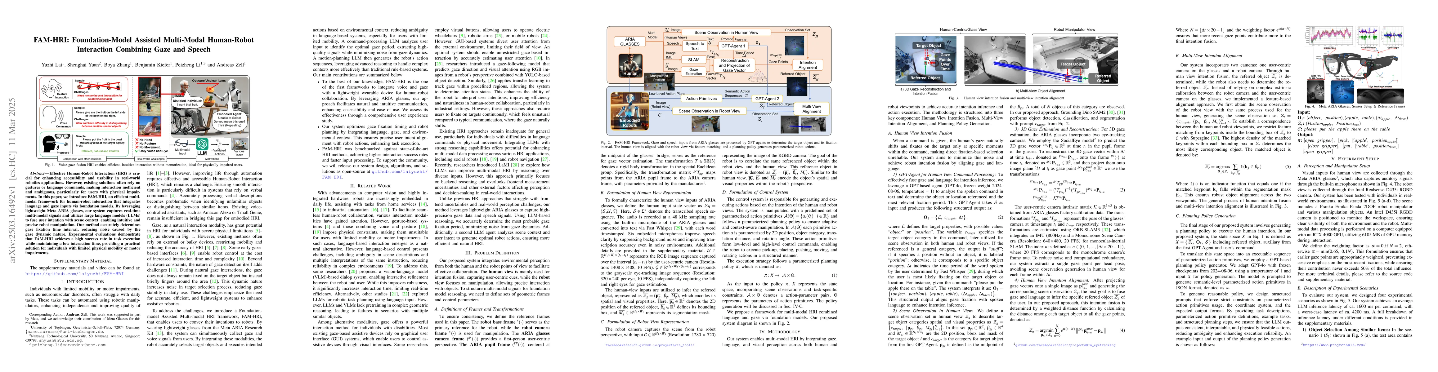
Effective Human-Robot Interaction (HRI) is crucial for enhancing accessibility and usability in real-world robotics applications. However, existing solutions often rely on gestures or language command...
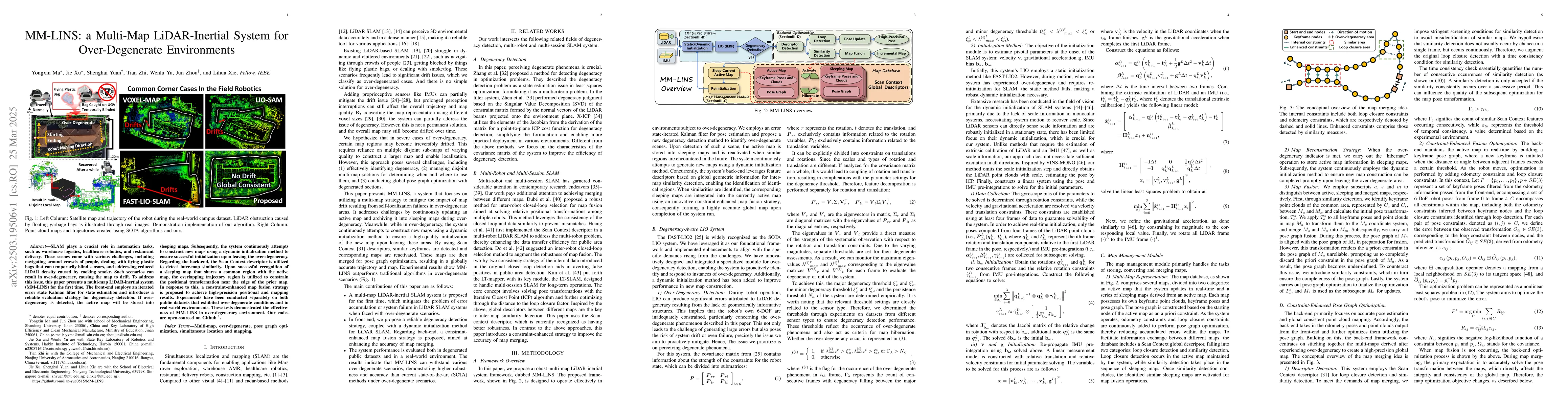
SLAM plays a crucial role in automation tasks, such as warehouse logistics, healthcare robotics, and restaurant delivery. These scenes come with various challenges, including navigating around crowds ...
LiDAR-Inertial Odometry (LIO) is widely used for autonomous navigation, but its deployment on Size, Weight, and Power (SWaP)-constrained platforms remains challenging due to the computational cost of ...
The recent breakthroughs in OpenAI's GPT4o model have demonstrated surprisingly good capabilities in image generation and editing, resulting in significant excitement in the community. This technical ...
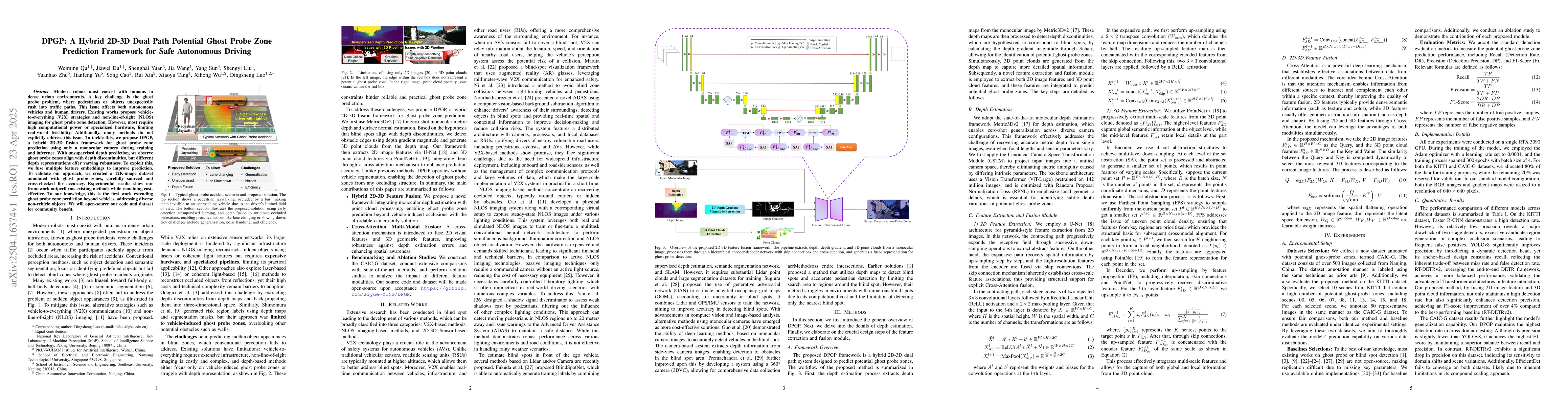
Modern robots must coexist with humans in dense urban environments. A key challenge is the ghost probe problem, where pedestrians or objects unexpectedly rush into traffic paths. This issue affects bo...
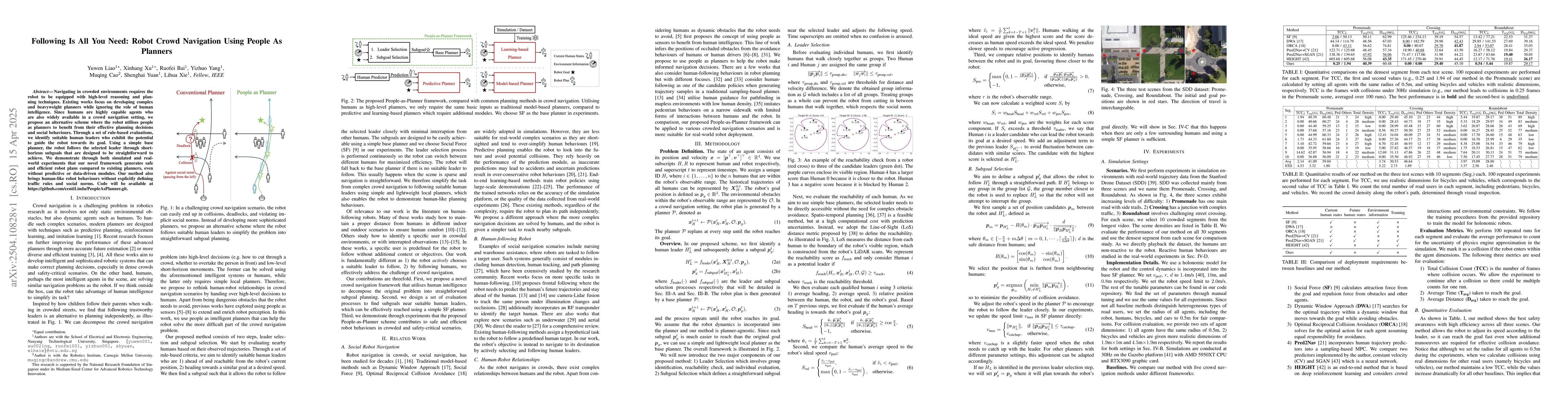
Navigating in crowded environments requires the robot to be equipped with high-level reasoning and planning techniques. Existing works focus on developing complex and heavyweight planners while ignori...
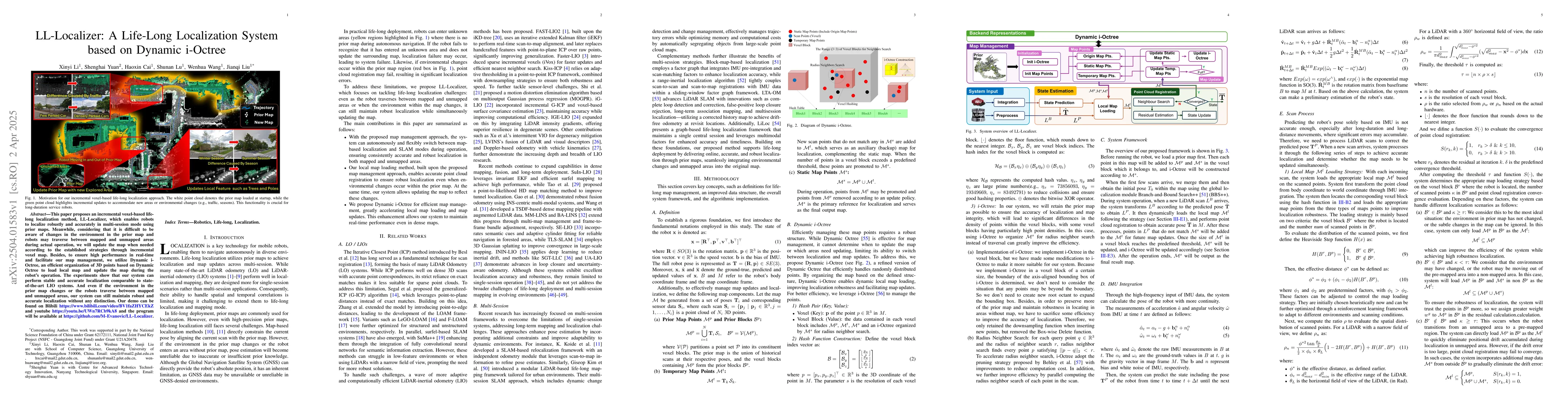
This paper proposes an incremental voxel-based life-long localization method, LL-Localizer, which enables robots to localize robustly and accurately in multi-session mode using prior maps. Meanwhile, ...
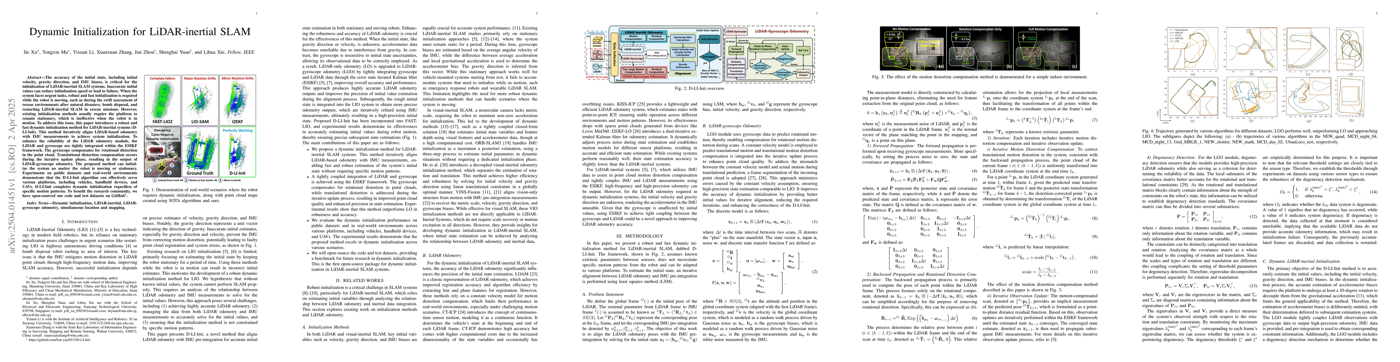
The accuracy of the initial state, including initial velocity, gravity direction, and IMU biases, is critical for the initialization of LiDAR-inertial SLAM systems. Inaccurate initial values can reduc...

Video generation has made substantial strides with the emergence of deep generative models, especially diffusion-based approaches. However, video generation based on multiple reference subjects still ...
Subject-to-Video (S2V) generation aims to create videos that faithfully incorporate reference content, providing enhanced flexibility in the production of videos. To establish the infrastructure for S...
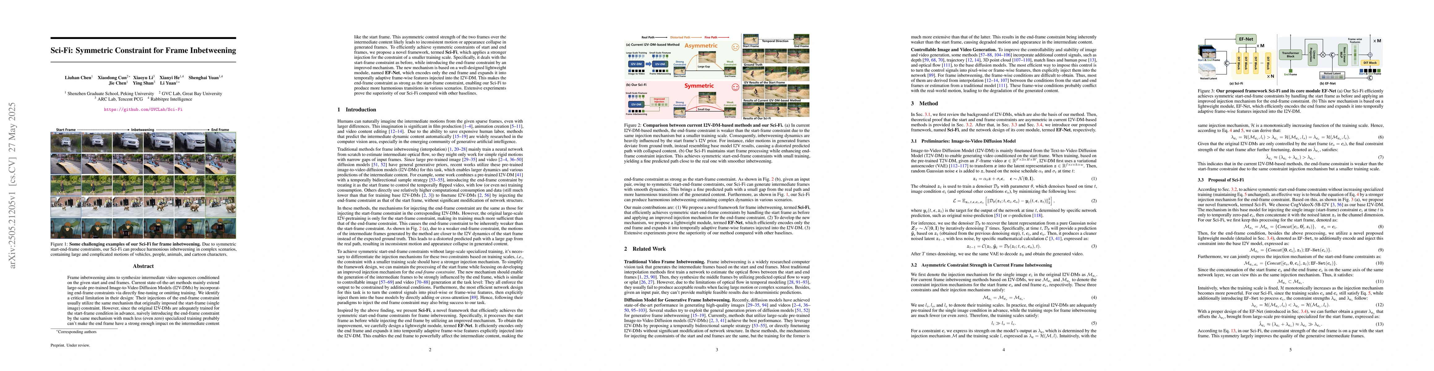
Frame inbetweening aims to synthesize intermediate video sequences conditioned on the given start and end frames. Current state-of-the-art methods mainly extend large-scale pre-trained Image-to-Video ...
Recent advancements in generative models have enabled high-fidelity text-to-image generation. However, open-source image-editing models still lag behind their proprietary counterparts, primarily due t...
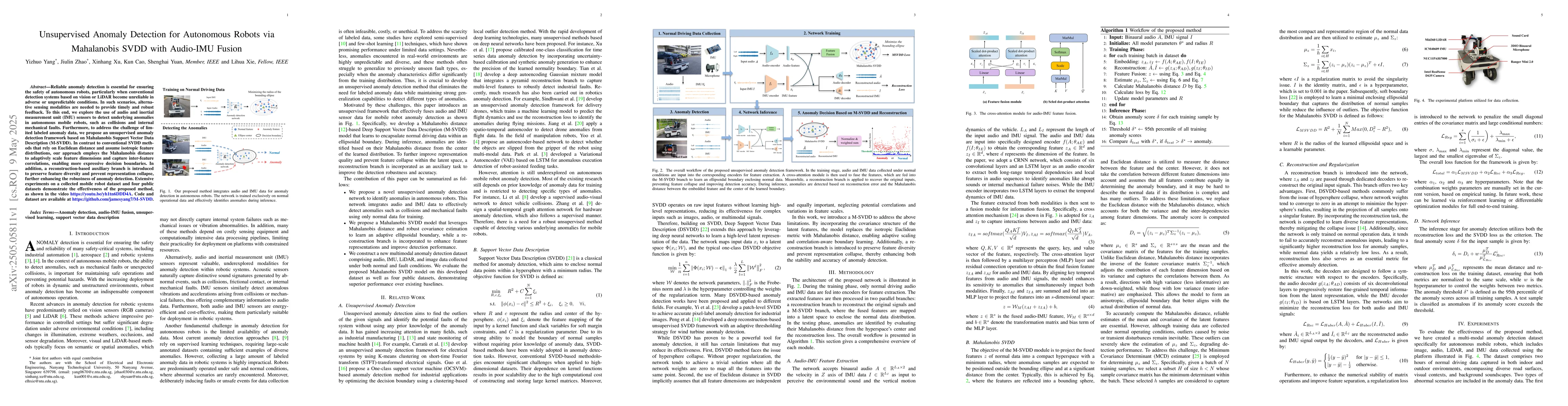
Reliable anomaly detection is essential for ensuring the safety of autonomous robots, particularly when conventional detection systems based on vision or LiDAR become unreliable in adverse or unpredic...
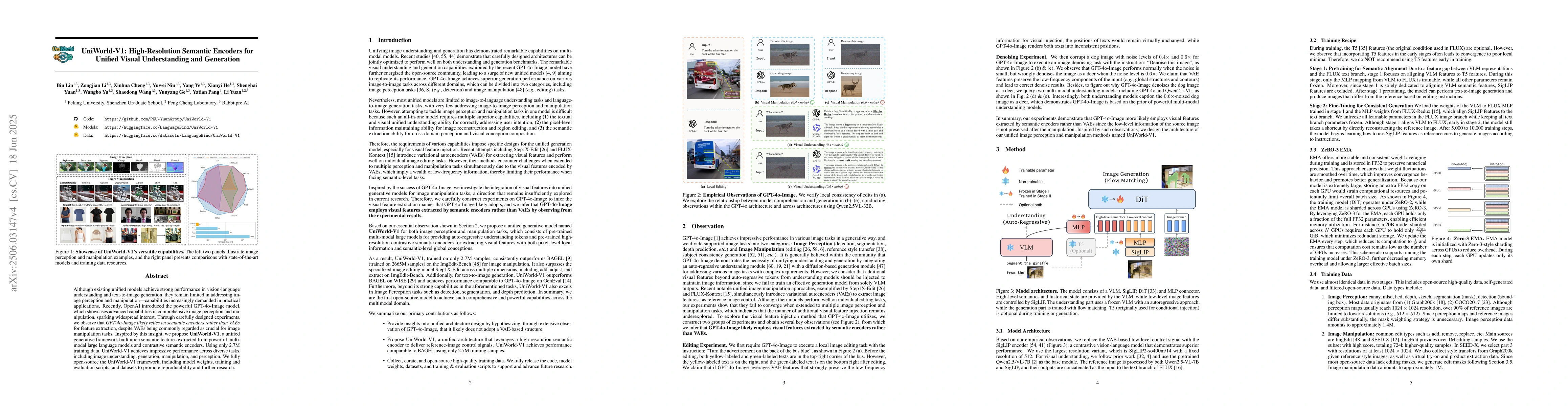
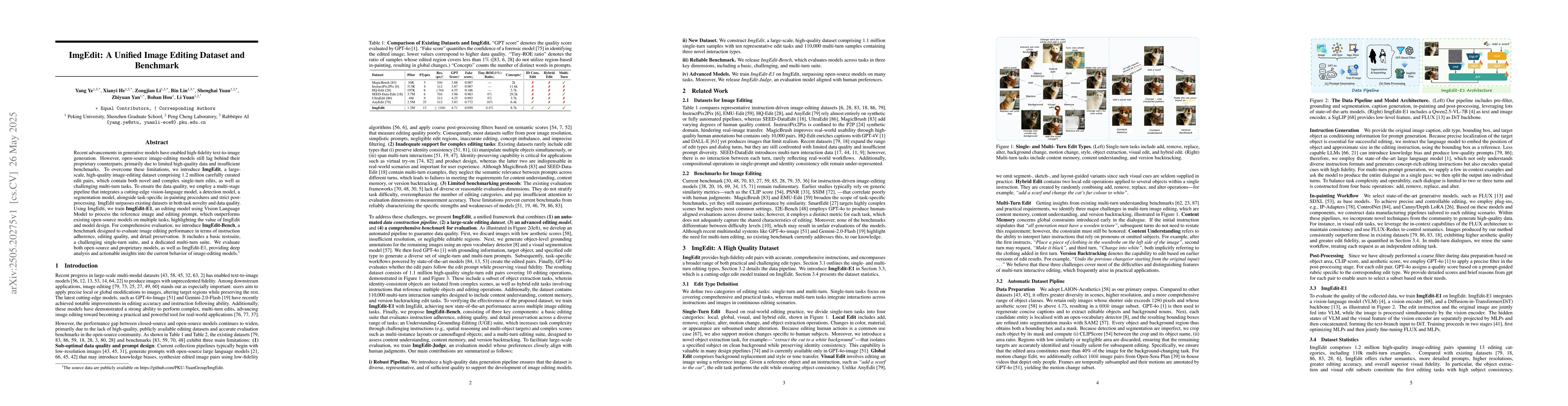
Although existing unified models achieve strong performance in vision-language understanding and text-to-image generation, they remain limited in addressing image perception and manipulation -- capabi...
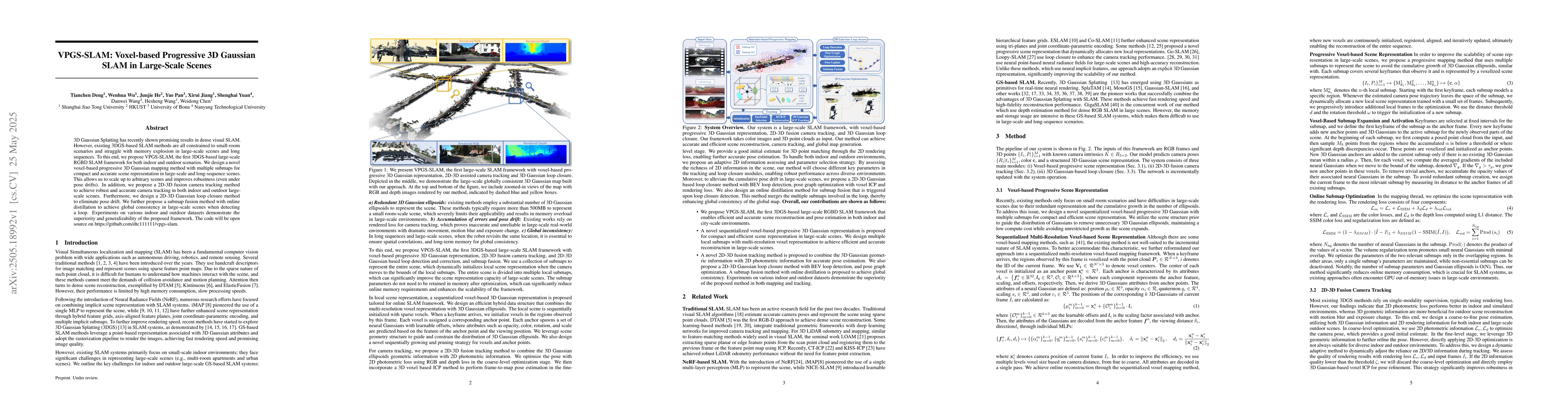
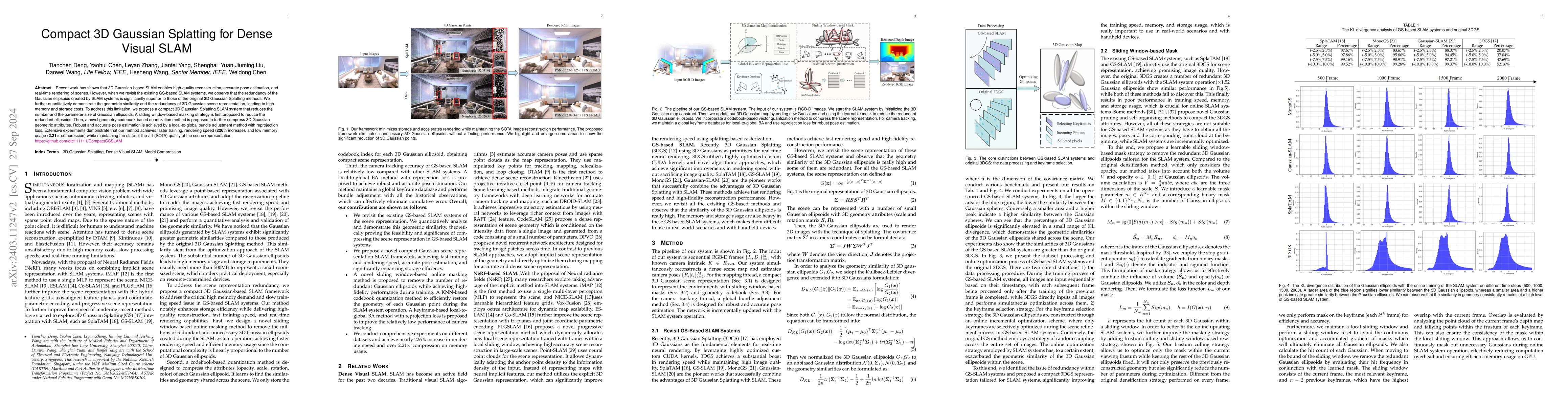
3D Gaussian Splatting has recently shown promising results in dense visual SLAM. However, existing 3DGS-based SLAM methods are all constrained to small-room scenarios and struggle with memory explosio...
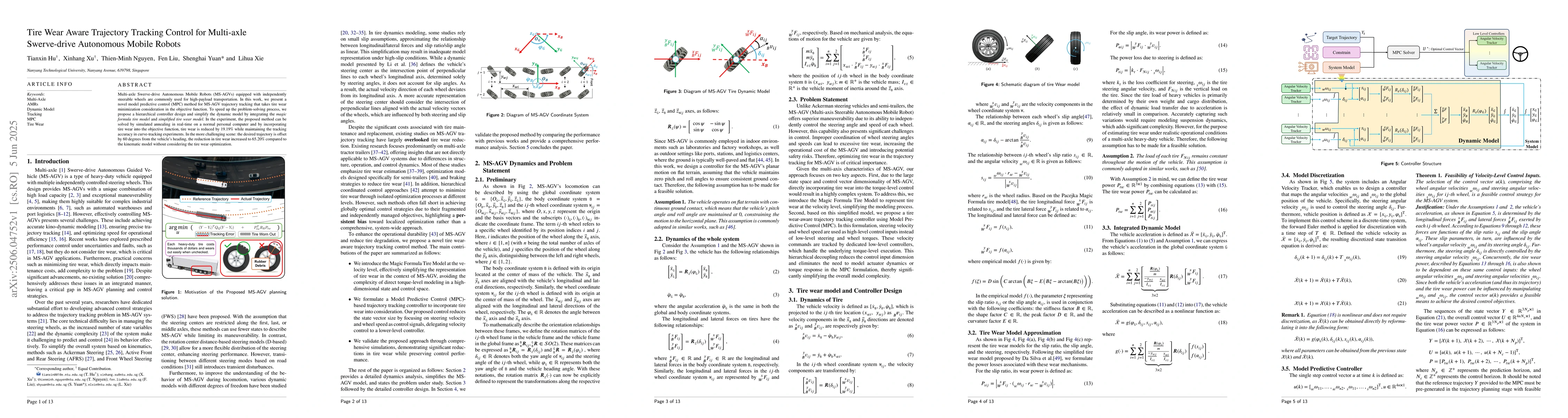
Multi-axle Swerve-drive Autonomous Mobile Robots (MS-AGVs) equipped with independently steerable wheels are commonly used for high-payload transportation. In this work, we present a novel model predic...
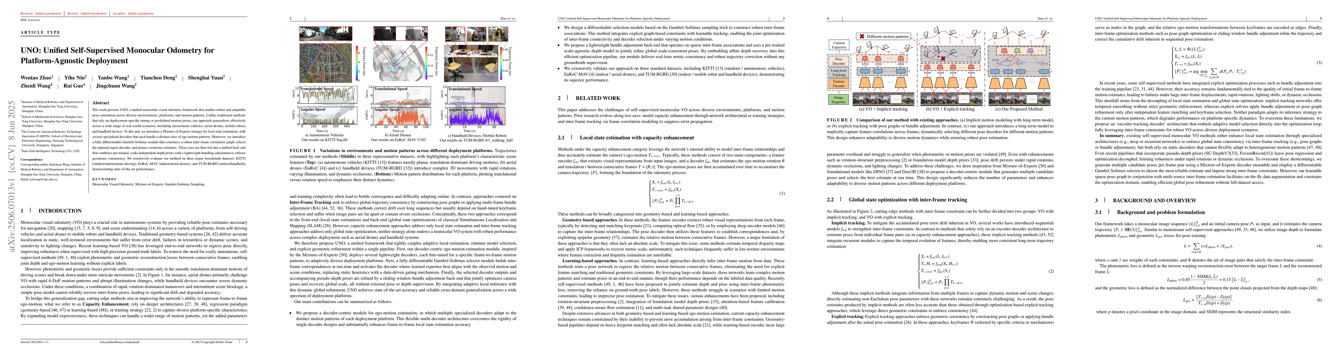
This work presents UNO, a unified monocular visual odometry framework that enables robust and adaptable pose estimation across diverse environments, platforms, and motion patterns. Unlike traditional ...
Commercial UAVs are an emerging security threat as they are capable of carrying hazardous payloads or disrupting air traffic. To counter UAVs, we introduce an autonomous 3D target encirclement and int...
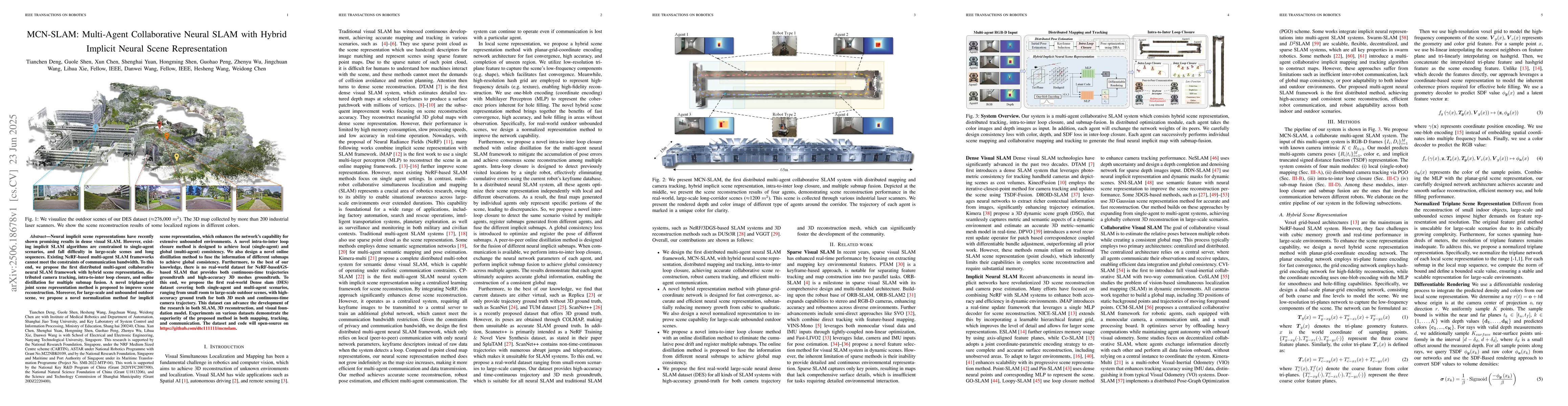
Neural implicit scene representations have recently shown promising results in dense visual SLAM. However, existing implicit SLAM algorithms are constrained to single-agent scenarios, and fall difficu...
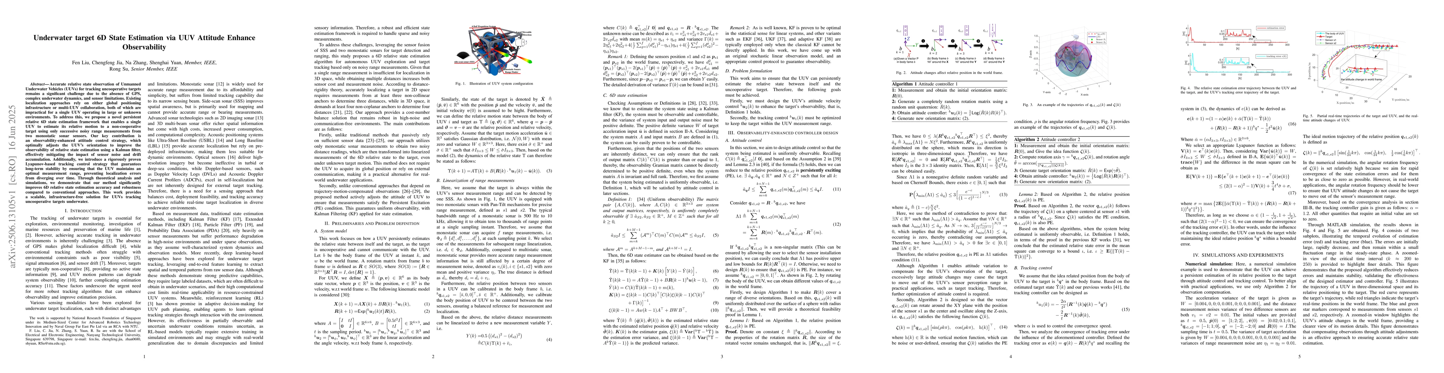
Accurate relative state observation of Unmanned Underwater Vehicles (UUVs) for tracking uncooperative targets remains a significant challenge due to the absence of GPS, complex underwater dynamics, an...
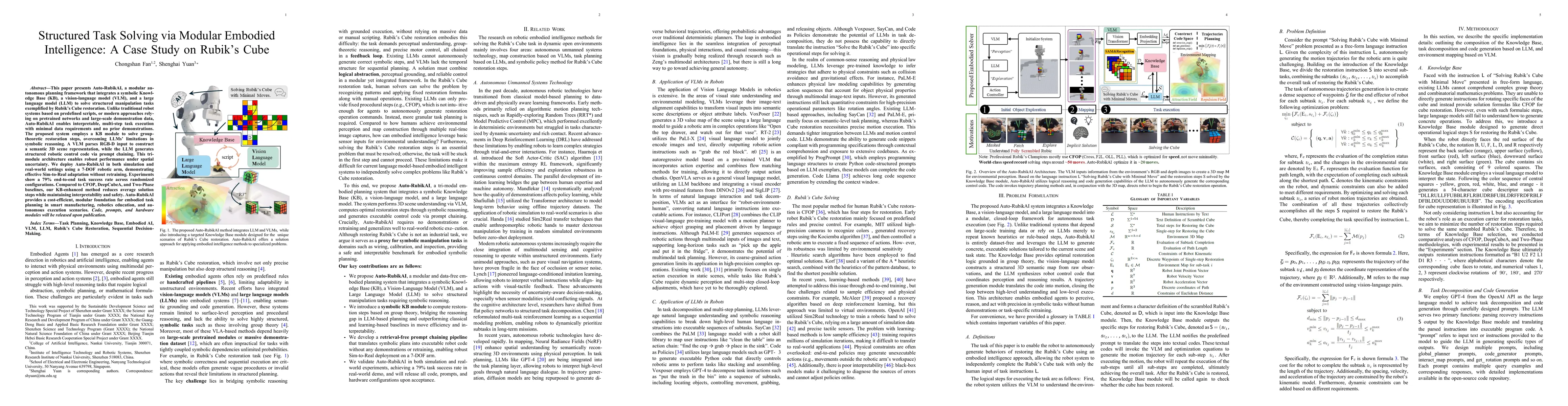
This paper presents Auto-RubikAI, a modular autonomous planning framework that integrates a symbolic Knowledge Base (KB), a vision-language model (VLM), and a large language model (LLM) to solve struc...
The widespread use of consumer drones has introduced serious challenges for airspace security and public safety. Their high agility and unpredictable motion make drones difficult to track and intercep...
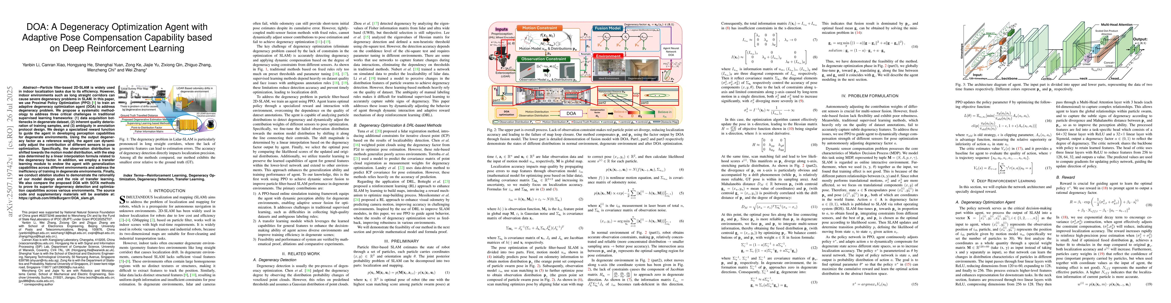
Particle filter-based 2D-SLAM is widely used in indoor localization tasks due to its efficiency. However, indoor environments such as long straight corridors can cause severe degeneracy problems in SL...
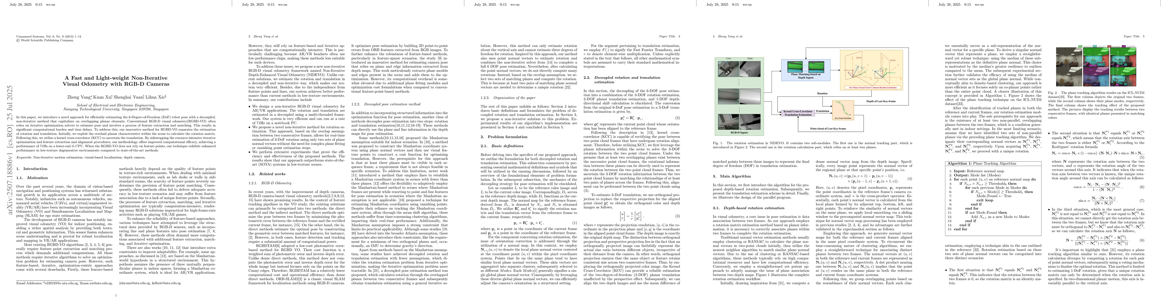
In this paper, we introduce a novel approach for efficiently estimating the 6-Degree-of-Freedom (DoF) robot pose with a decoupled, non-iterative method that capitalizes on overlapping planar elements....
Multi-modal perception is essential for unmanned aerial vehicle (UAV) operations, as it enables a comprehensive understanding of the UAVs' surrounding environment. However, most existing multi-modal U...
Monocular 3D Semantic Scene Completion (SSC) is a challenging yet promising task that aims to infer dense geometric and semantic descriptions of a scene from a single image. While recent object-centri...
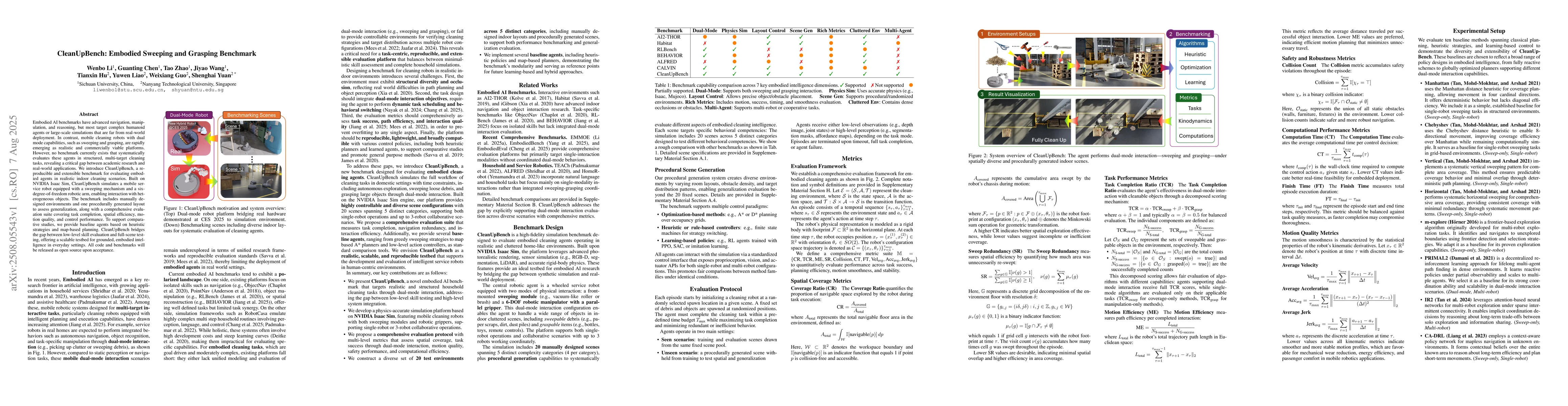
Embodied AI benchmarks have advanced navigation, manipulation, and reasoning, but most target complex humanoid agents or large-scale simulations that are far from real-world deployment. In contrast, m...
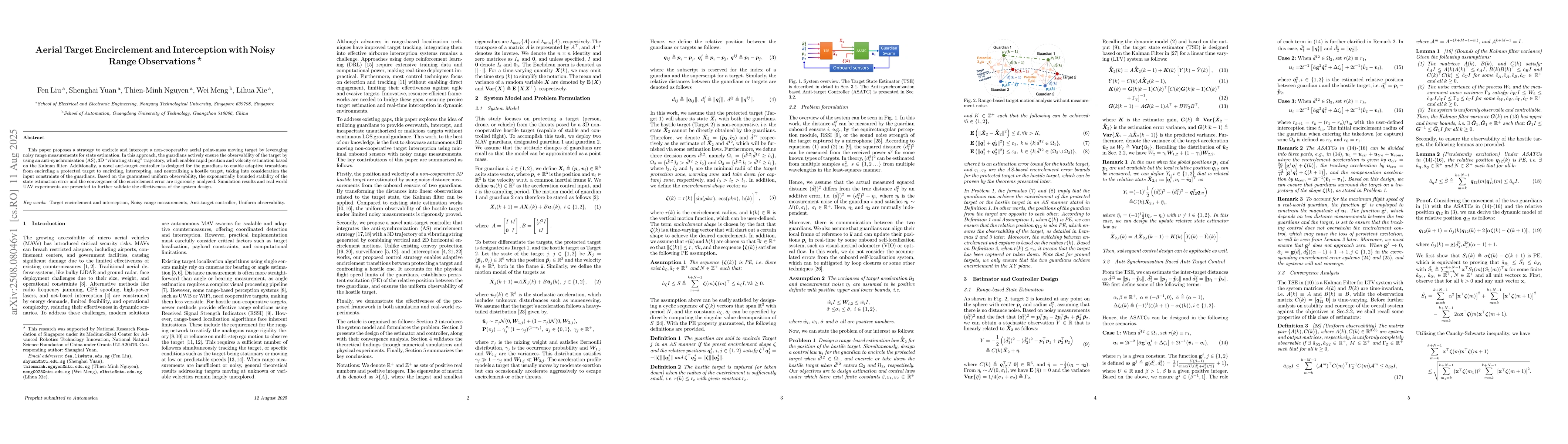
This paper proposes a strategy to encircle and intercept a non-cooperative aerial point-mass moving target by leveraging noisy range measurements for state estimation. In this approach, the guardians ...
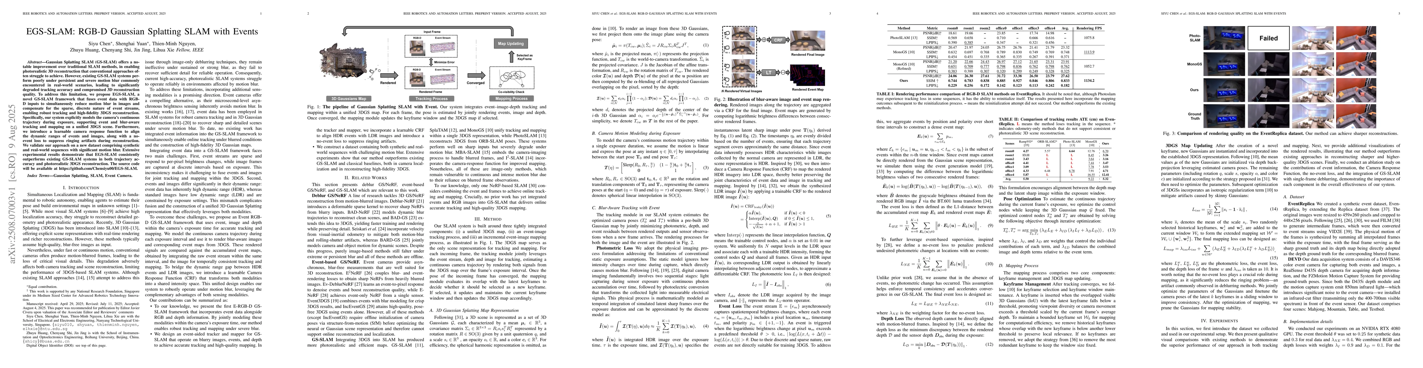
Gaussian Splatting SLAM (GS-SLAM) offers a notable improvement over traditional SLAM methods, enabling photorealistic 3D reconstruction that conventional approaches often struggle to achieve. However,...
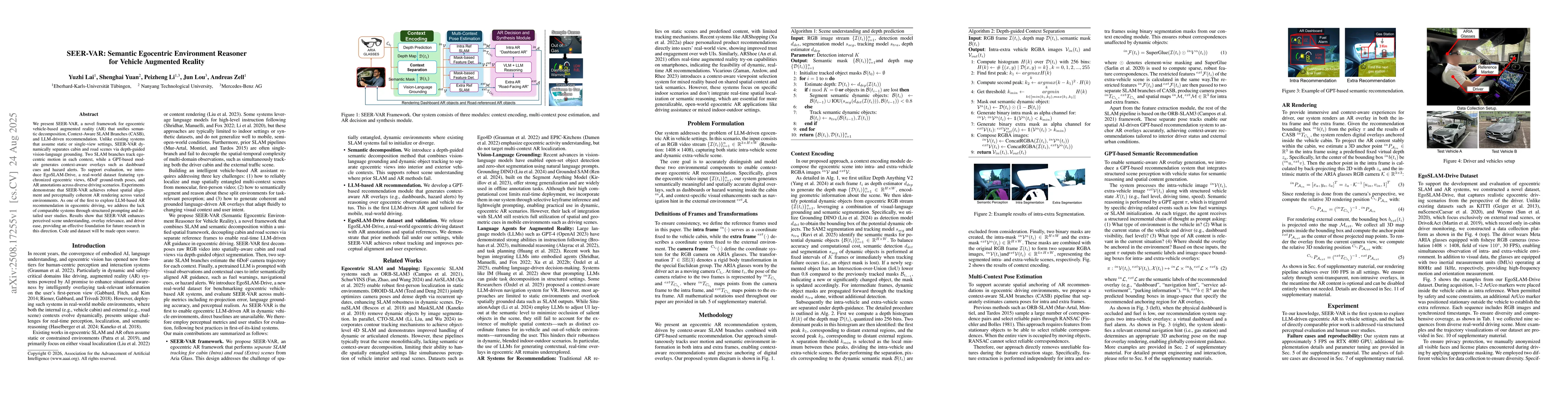
We present SEER-VAR, a novel framework for egocentric vehicle-based augmented reality (AR) that unifies semantic decomposition, Context-Aware SLAM Branches (CASB), and LLM-driven recommendation. Unlik...
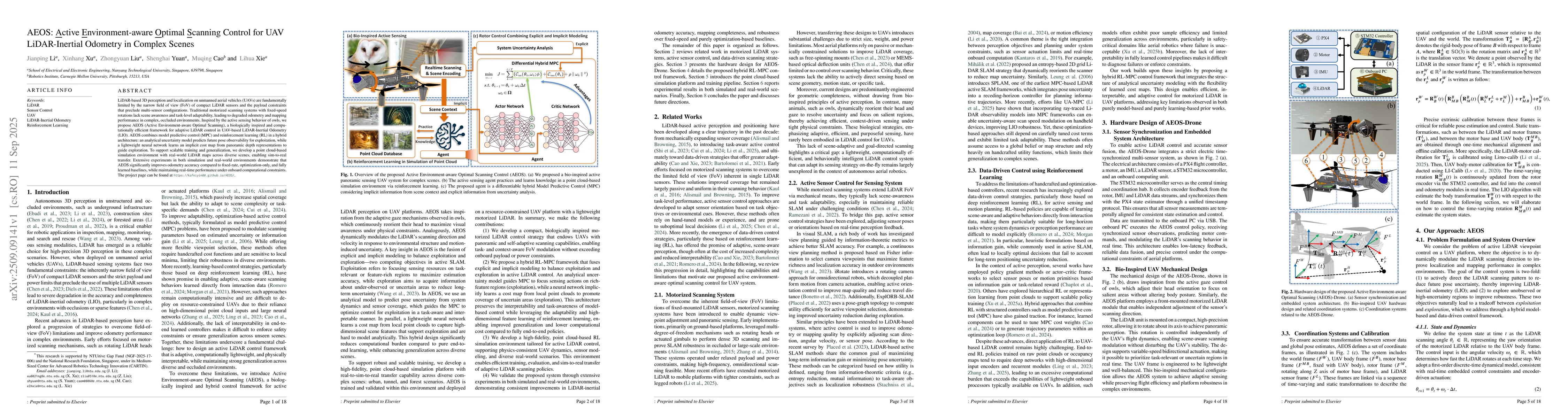
LiDAR-based 3D perception and localization on unmanned aerial vehicles (UAVs) are fundamentally limited by the narrow field of view (FoV) of compact LiDAR sensors and the payload constraints that prec...
Automatic docking has long been a significant challenge in the field of mobile robotics. Compared to other automatic docking methods, visual docking methods offer higher precision and lower deployment...
Event cameras capture asynchronous pixel-level brightness changes with microsecond temporal resolution, offering unique advantages for high-speed vision tasks. Existing methods often convert event str...
Modern signal processing (SP) pipelines, whether model-based or data-driven, often constrained by complex and fragmented workflow, rely heavily on expert knowledge and manual engineering, and struggle...
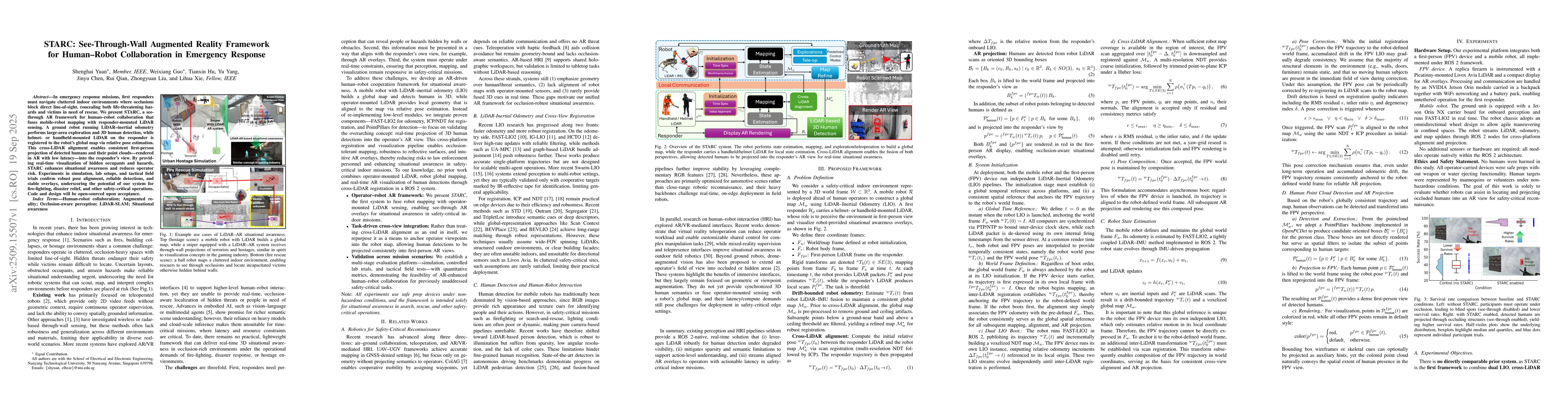
In emergency response missions, first responders must navigate cluttered indoor environments where occlusions block direct line-of-sight, concealing both life-threatening hazards and victims in need o...
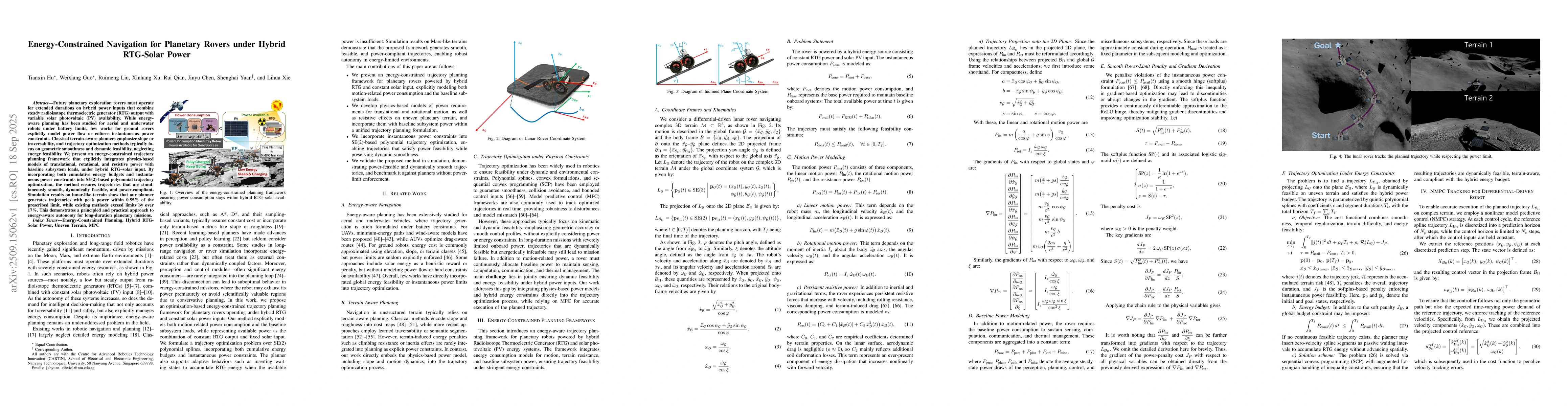
Future planetary exploration rovers must operate for extended durations on hybrid power inputs that combine steady radioisotope thermoelectric generator (RTG) output with variable solar photovoltaic (...
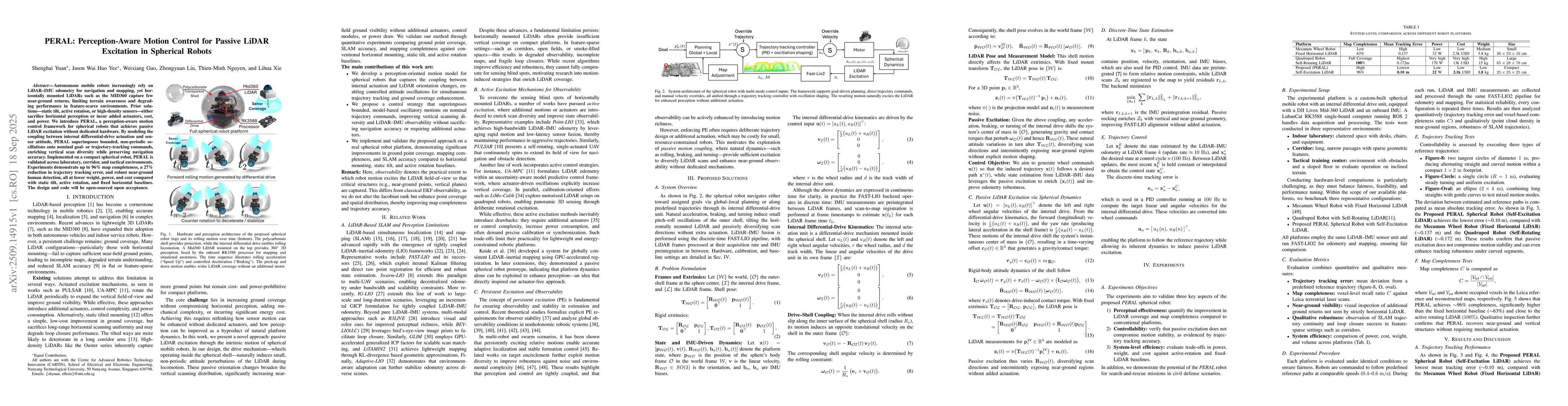
Autonomous mobile robots increasingly rely on LiDAR-IMU odometry for navigation and mapping, yet horizontally mounted LiDARs such as the MID360 capture few near-ground returns, limiting terrain awaren...
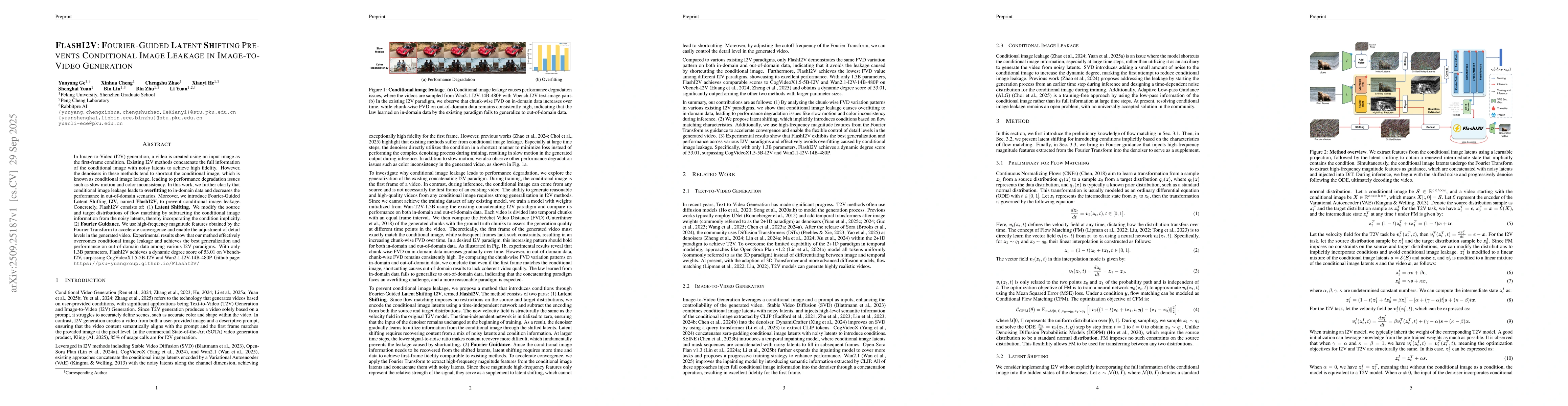
In Image-to-Video (I2V) generation, a video is created using an input image as the first-frame condition. Existing I2V methods concatenate the full information of the conditional image with noisy late...
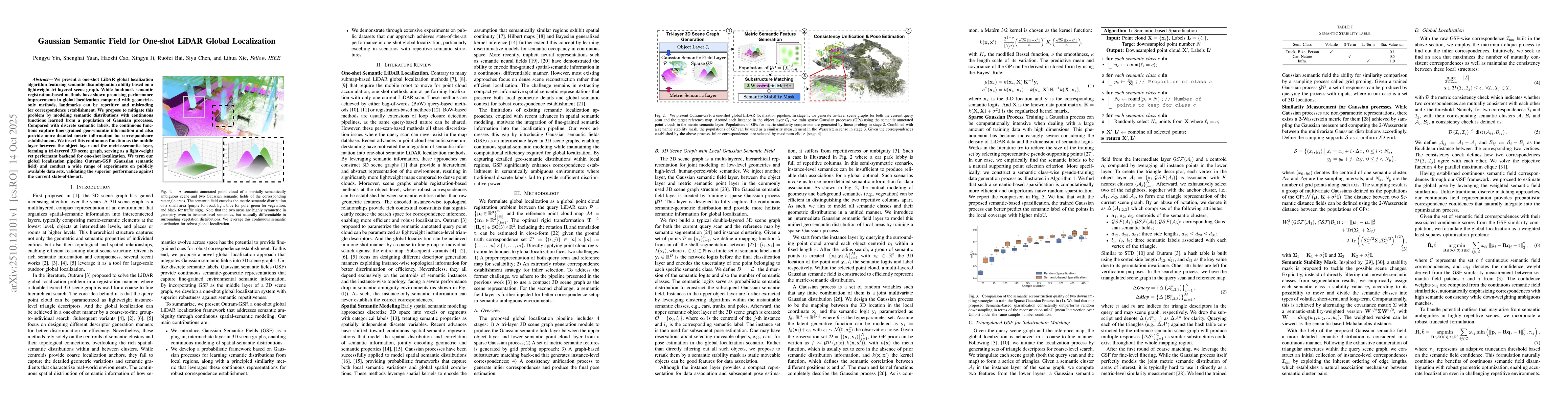
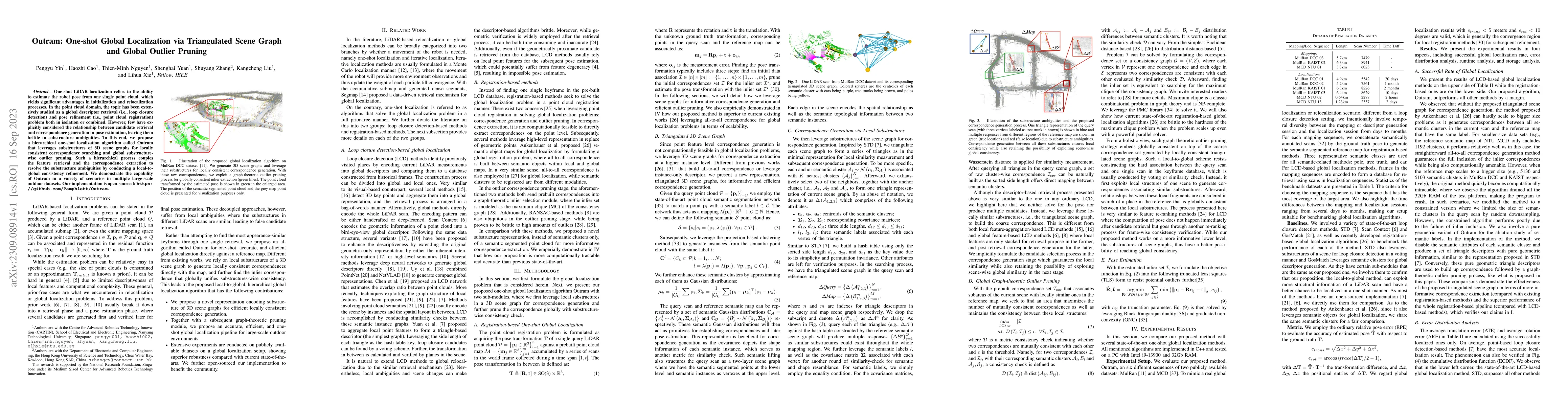
We present a one-shot LiDAR global localization algorithm featuring semantic disambiguation ability based on a lightweight tri-layered scene graph. While landmark semantic registration-based methods h...
Instruction-based image editing has achieved remarkable progress; however, models solely trained via supervised fine-tuning often overfit to annotated patterns, hindering their ability to explore and ...
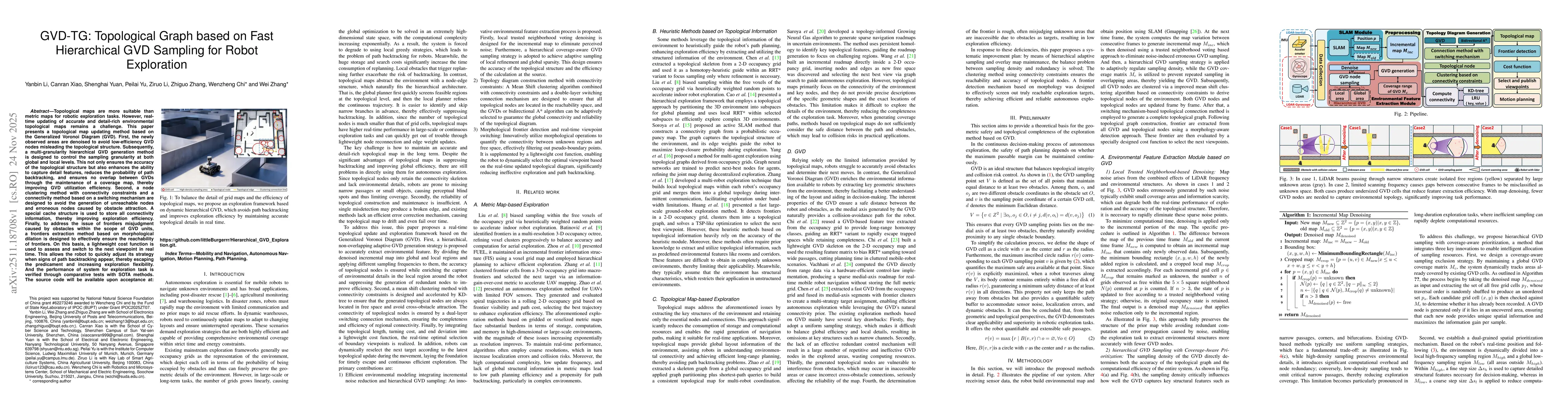
Topological maps are more suitable than metric maps for robotic exploration tasks. However, real-time updating of accurate and detail-rich environmental topological maps remains a challenge. This pape...
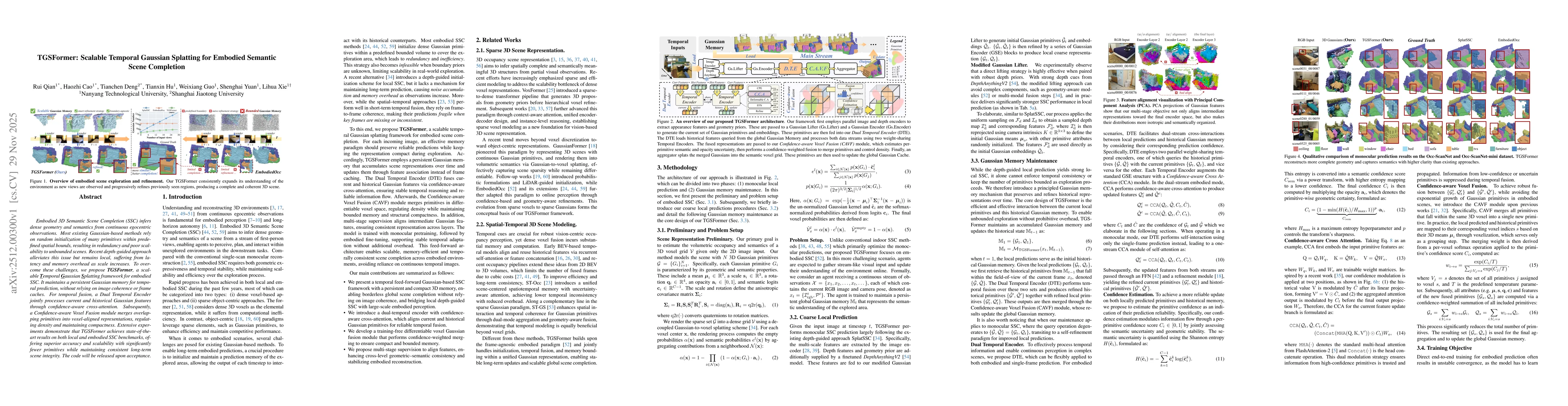
Embodied 3D Semantic Scene Completion (SSC) infers dense geometry and semantics from continuous egocentric observations. Most existing Gaussian-based methods rely on random initialization of many prim...
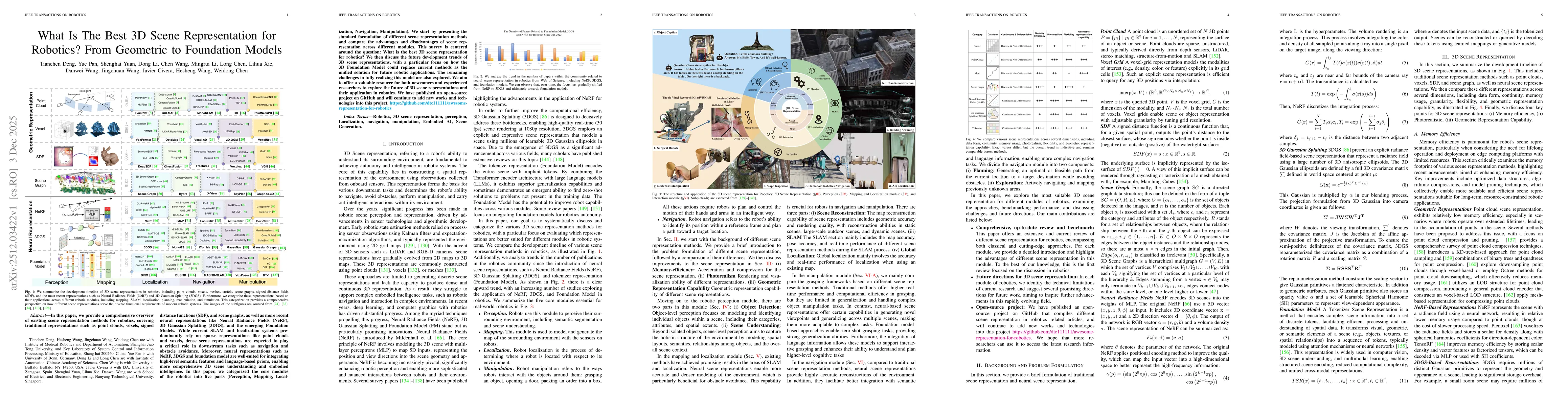
In this paper, we provide a comprehensive overview of existing scene representation methods for robotics, covering traditional representations such as point clouds, voxels, signed distance functions (...
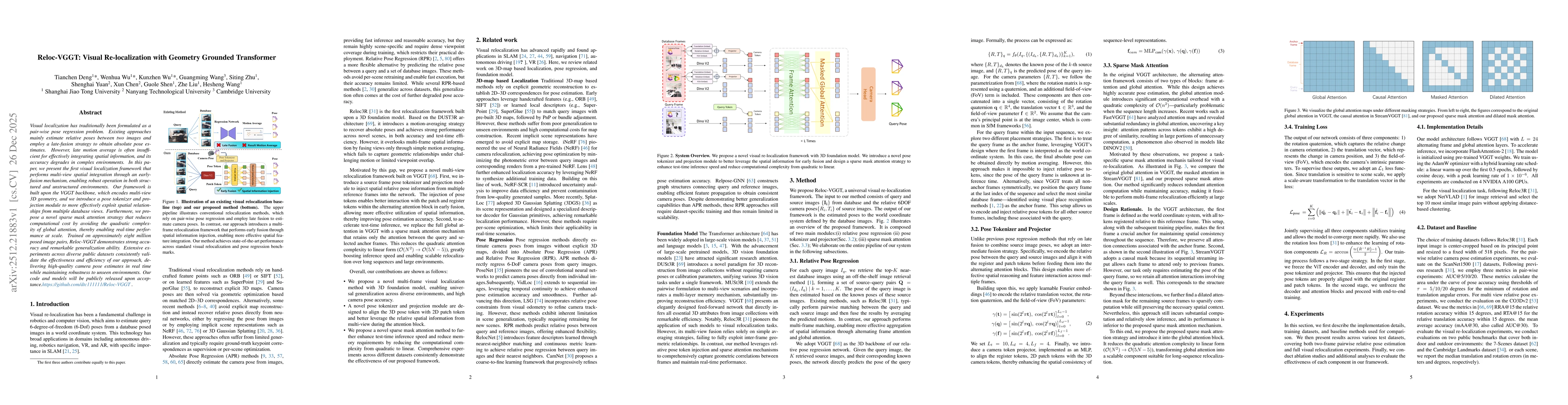
Visual localization has traditionally been formulated as a pair-wise pose regression problem. Existing approaches mainly estimate relative poses between two images and employ a late-fusion strategy to...
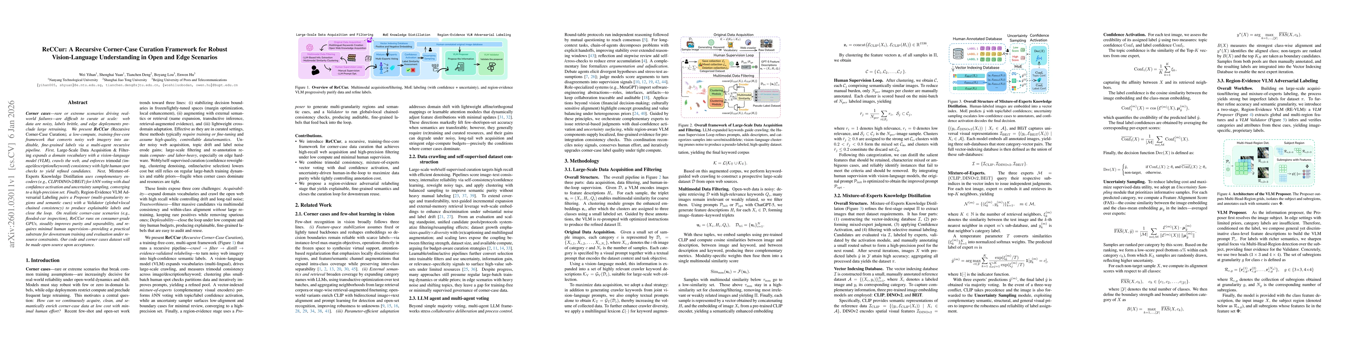
Corner cases are rare or extreme scenarios that drive real-world failures, but they are difficult to curate at scale: web data are noisy, labels are brittle, and edge deployments preclude large retrai...
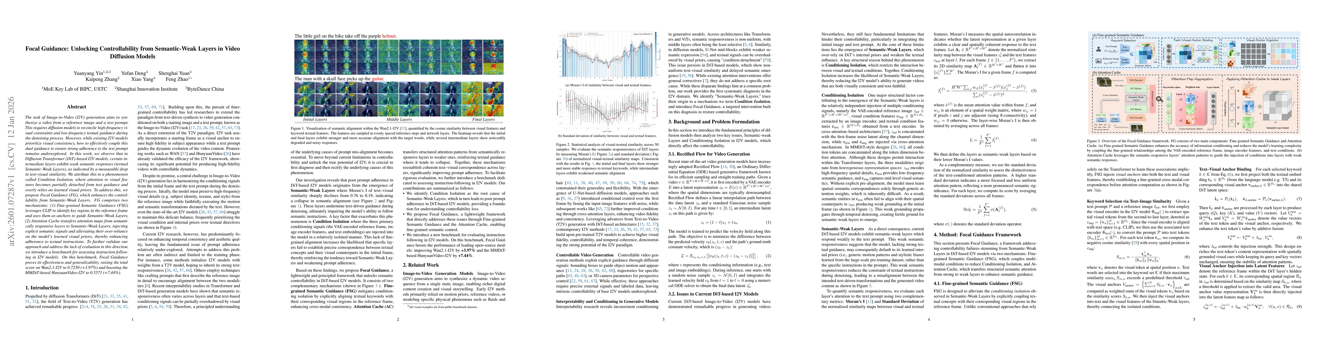
The task of Image-to-Video (I2V) generation aims to synthesize a video from a reference image and a text prompt. This requires diffusion models to reconcile high-frequency visual constraints and low-f...
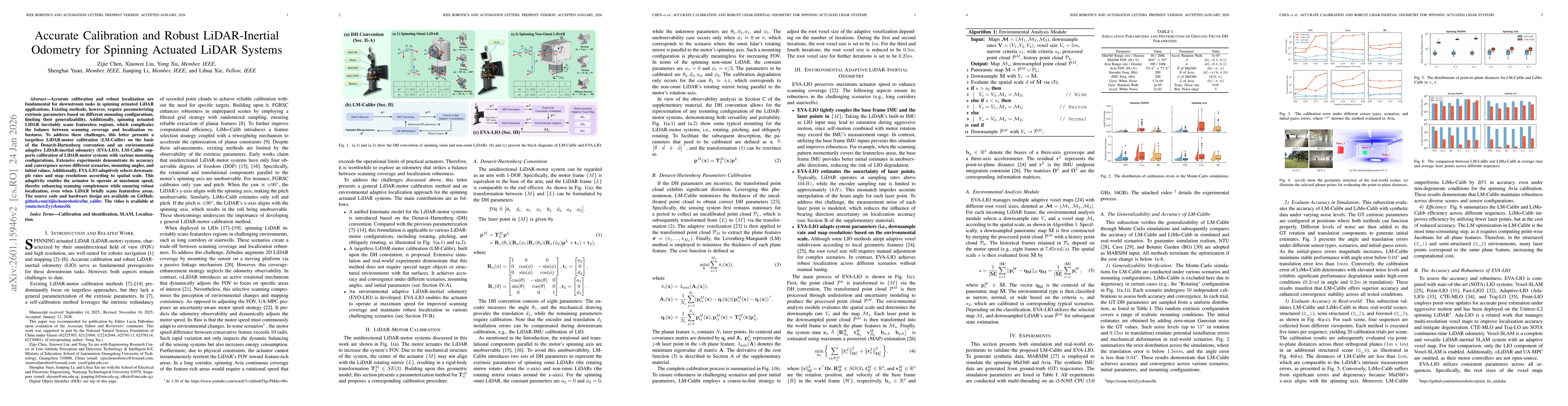
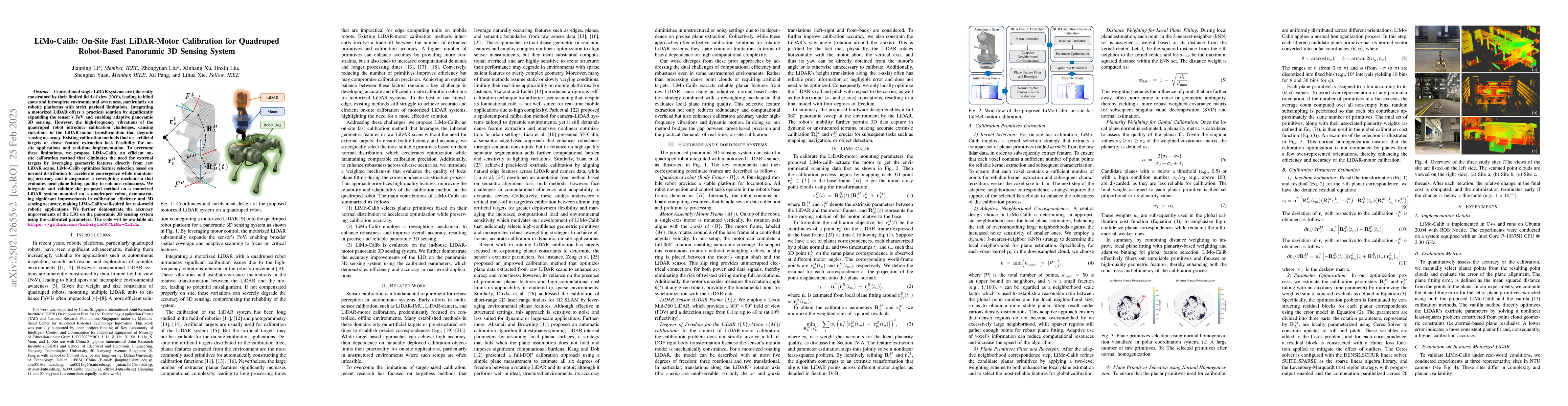
Accurate calibration and robust localization are fundamental for downstream tasks in spinning actuated LiDAR applications. Existing methods, however, require parameterizing extrinsic parameters based ...
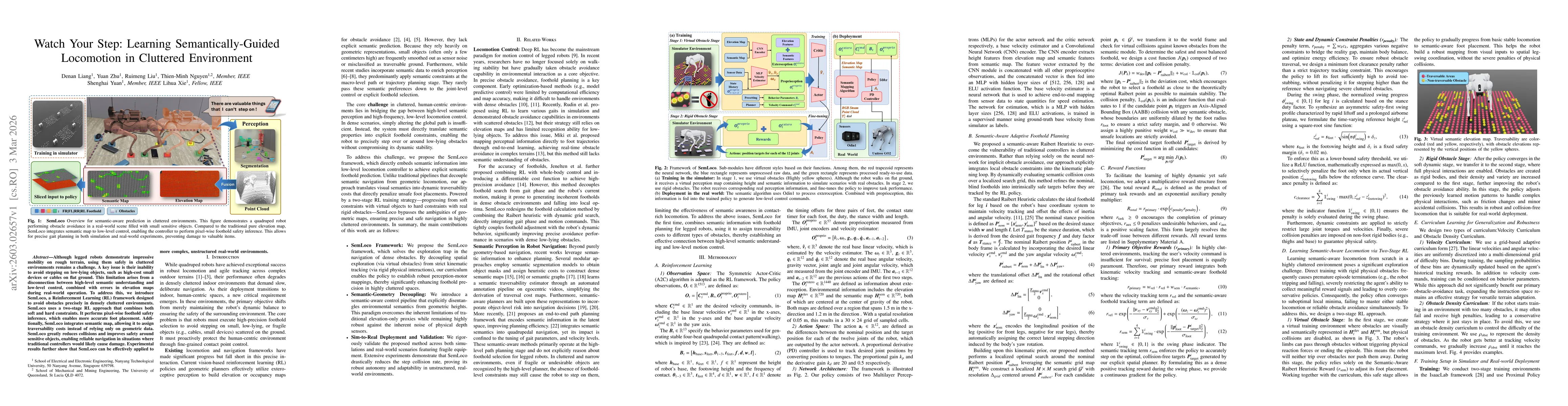
Although legged robots demonstrate impressive mobility on rough terrain, using them safely in cluttered environments remains a challenge. A key issue is their inability to avoid stepping on low-lying ...

We introduce Helios, the first 14B video generation model that runs at 19.5 FPS on a single NVIDIA H100 GPU and supports minute-scale generation while matching the quality of a strong baseline. We mak...
Gaze is a valuable means of communication for impaired people with extremely limited motor capabilities. However, robust gaze-based intent recognition in multi-object environments is challenging due t...
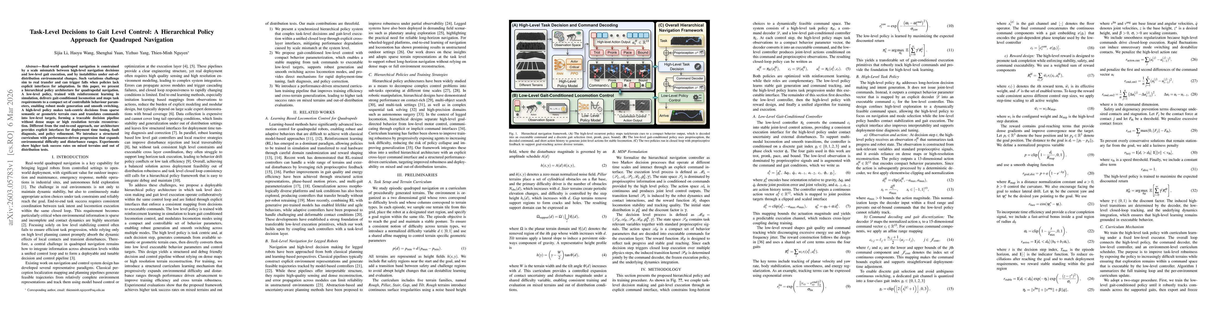
Real-world quadruped navigation is constrained by a scale mismatch between high-level navigation decisions and low-level gait execution, as well as by instabilities under out-of-distribution environme...
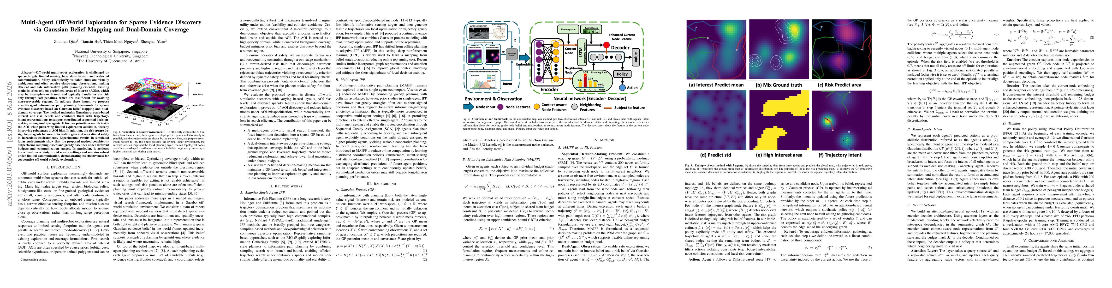
Off-world multi-robot exploration is challenged by sparse targets, limited sensing, hazardous terrain, and restricted communication. Many scientifically valuable clues are visually ambiguous and often...

Autonomous collision-free navigation in cluttered environments requires safe decision-making under partial observability with both static structure and dynamic obstacles. We present \textbf{PanoDP}, a...
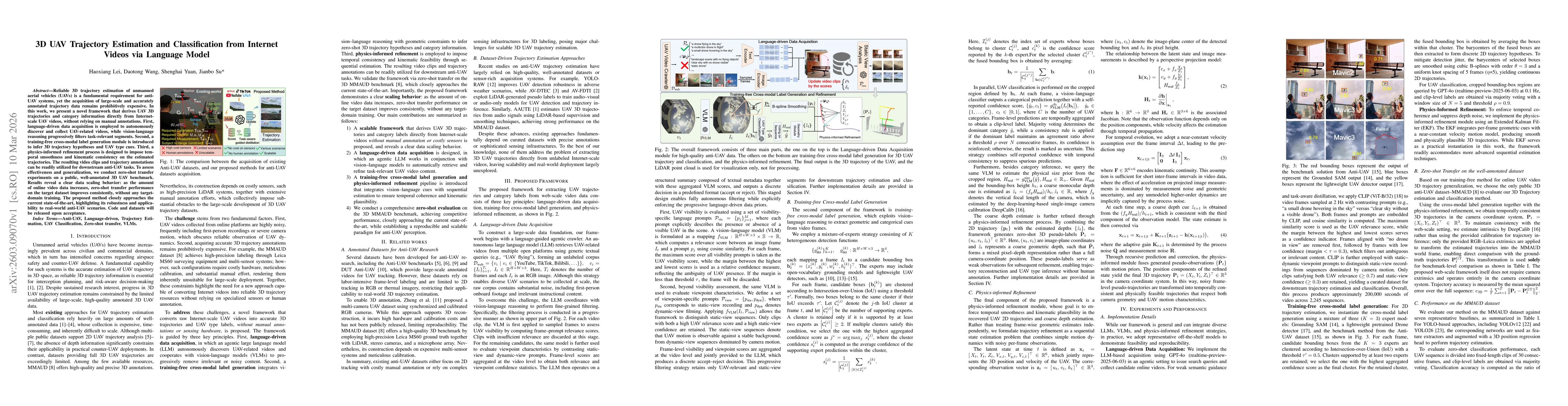
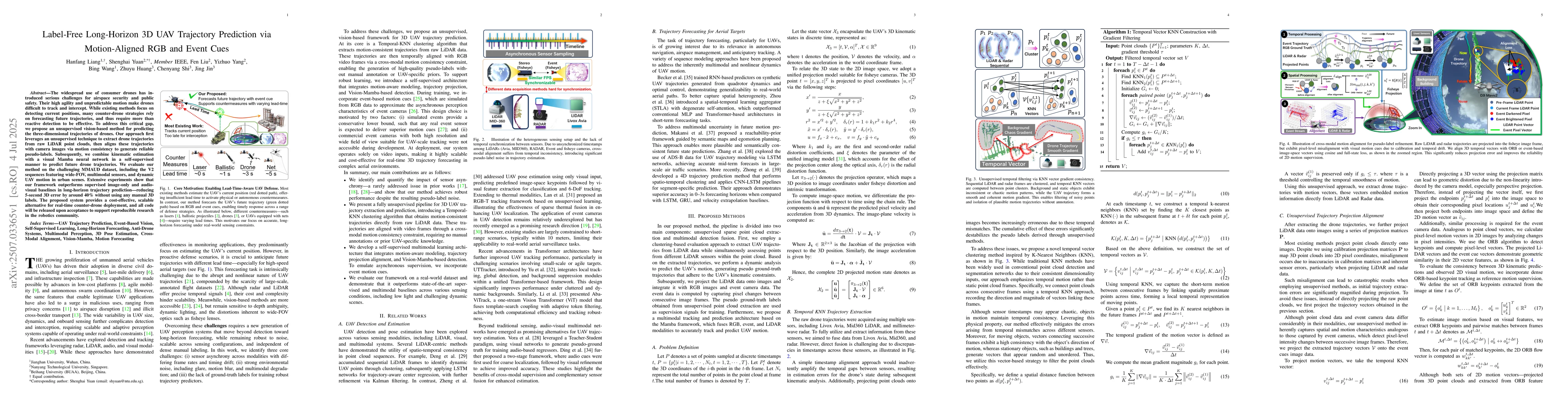
Reliable 3D trajectory estimation of unmanned aerial vehicles (UAVs) is a fundamental requirement for anti-UAV systems, yet the acquisition of large-scale and accurately annotated trajectory data rema...
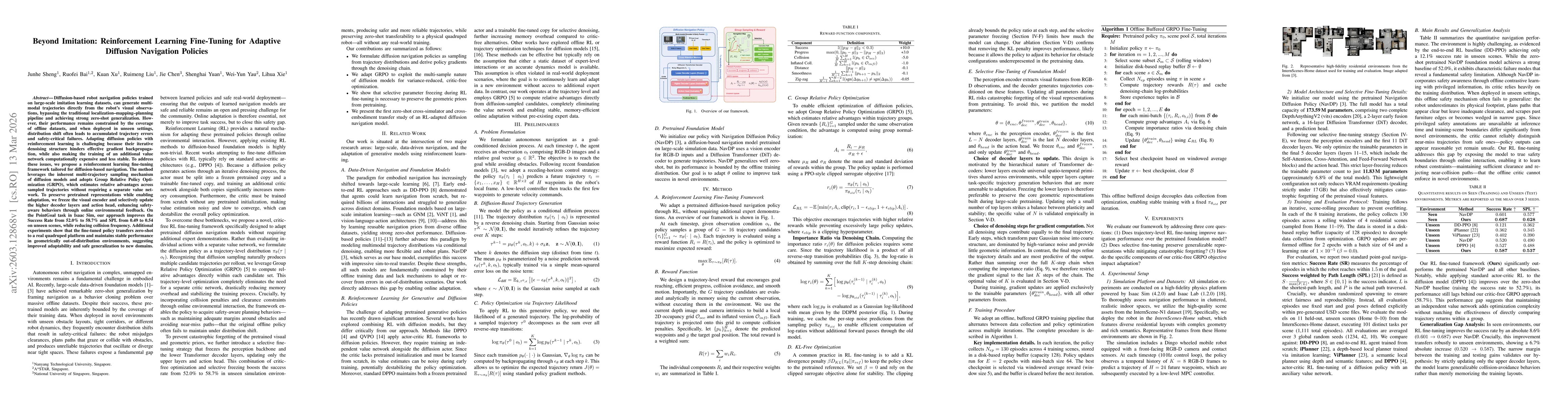
Diffusion-based robot navigation policies trained on large-scale imitation learning datasets, can generate multi-modal trajectories directly from the robot's visual observations, bypassing the traditi...
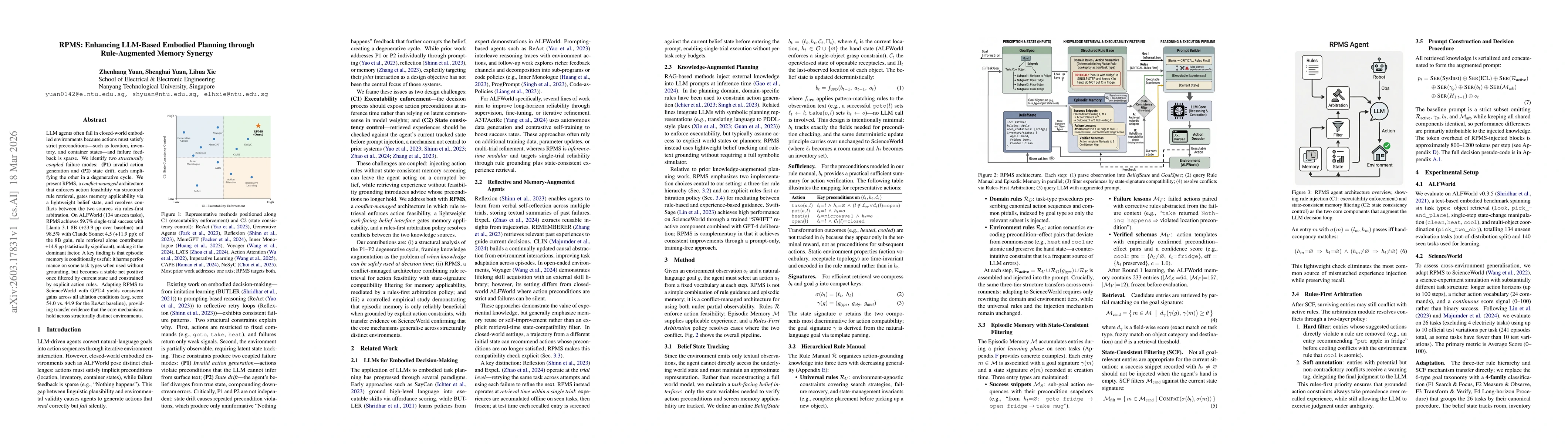
LLM agents often fail in closed-world embodied environments because actions must satisfy strict preconditions -- such as location, inventory, and container states -- and failure feedback is sparse. We...
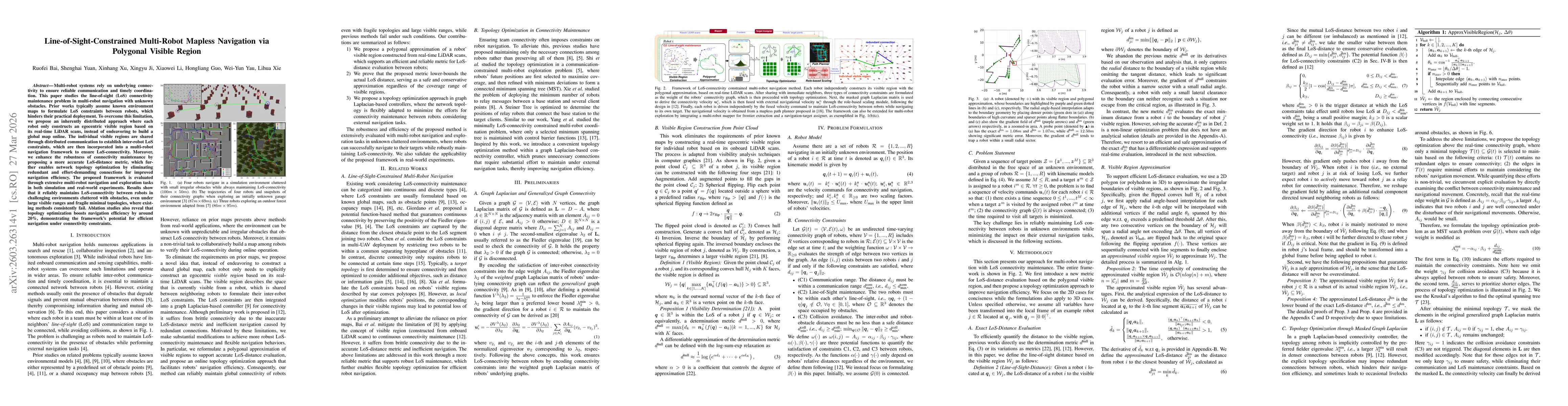
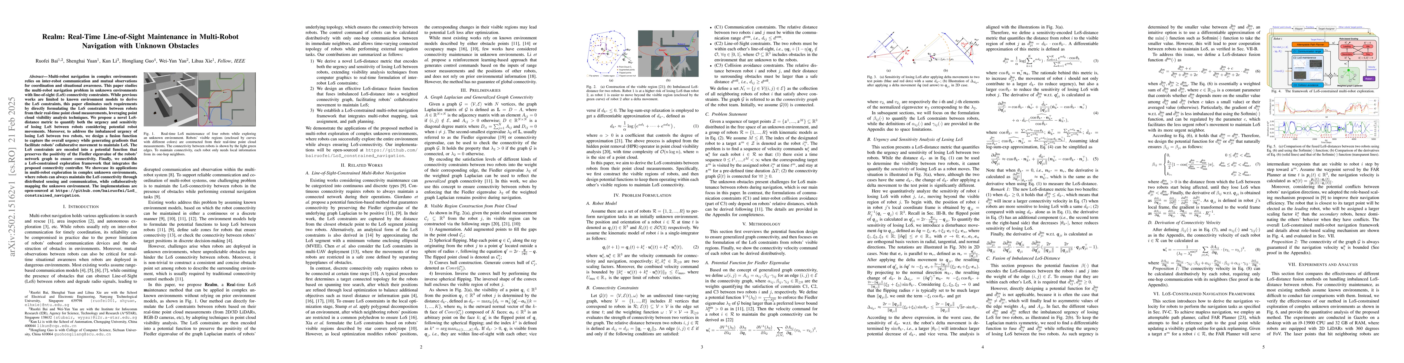
Multi-robot systems rely on underlying connectivity to ensure reliable communication and timely coordination. This paper studies the line-of-sight (LoS) connectivity maintenance problem in multi-robot...
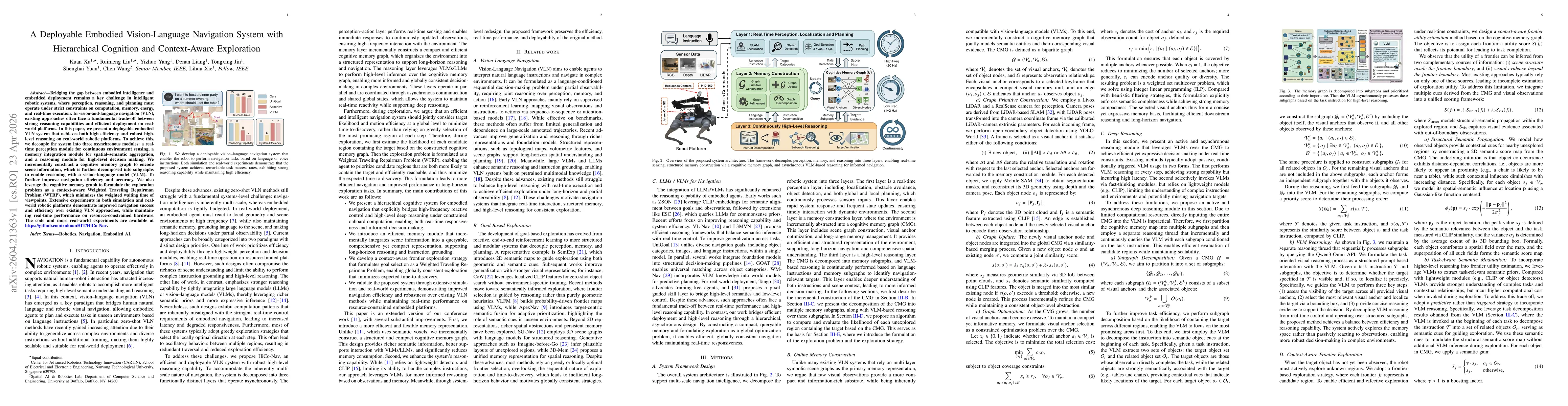
Bridging the gap between embodied intelligence and embedded deployment remains a key challenge in intelligent robotic systems, where perception, reasoning, and planning must operate under strict const...
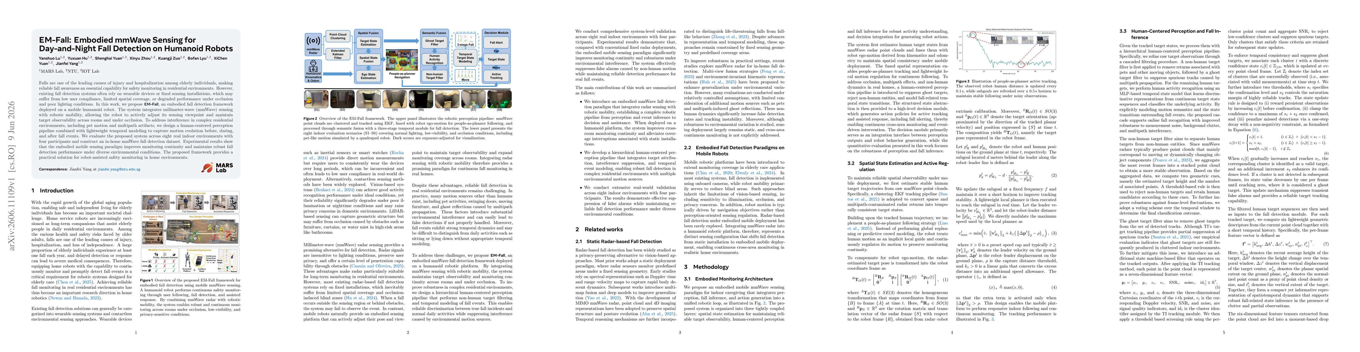
Falls are one of the leading causes of injury and hospitalization among elderly individuals, making reliable fall awareness an essential capability for safety monitoring in residential environments. H...

Reliable sound source localization is fundamental to robot audition, enabling autonomous robots to perceive spatial cues and operate effectively in dynamic environments. Classical methods such as Mult...
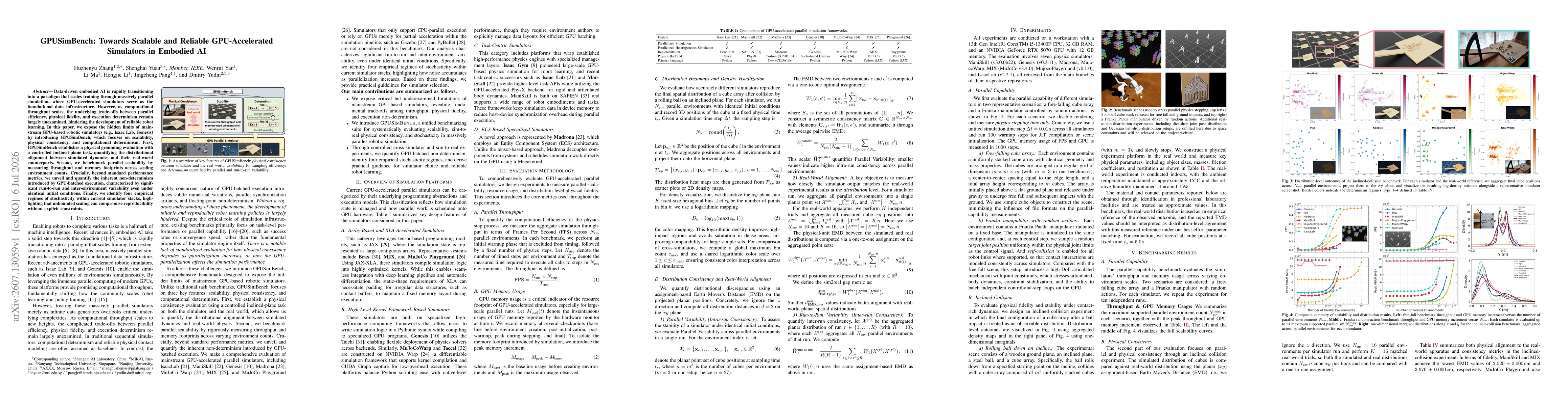
Data-driven embodied AI is rapidly transitioning into a paradigm that scales training through massively parallel simulation, where GPU-accelerated simulators serve as the foundational data infrastruct...