Academic Profile
Statistics
Similar Authors
Papers on arXiv
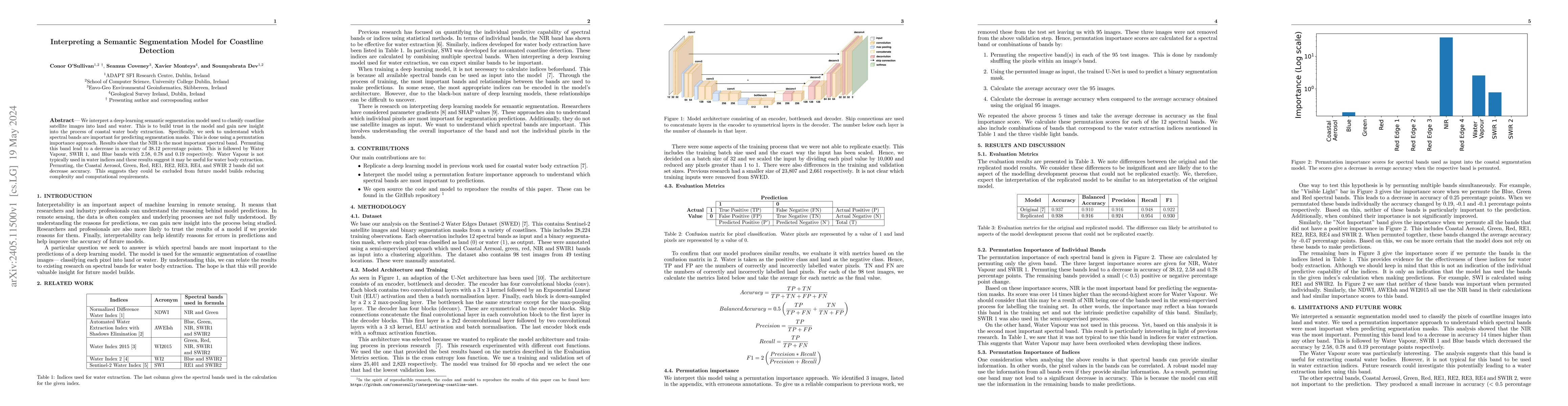
We interpret a deep-learning semantic segmentation model used to classify coastline satellite images into land and water. This is to build trust in the model and gain new insight into the process of...
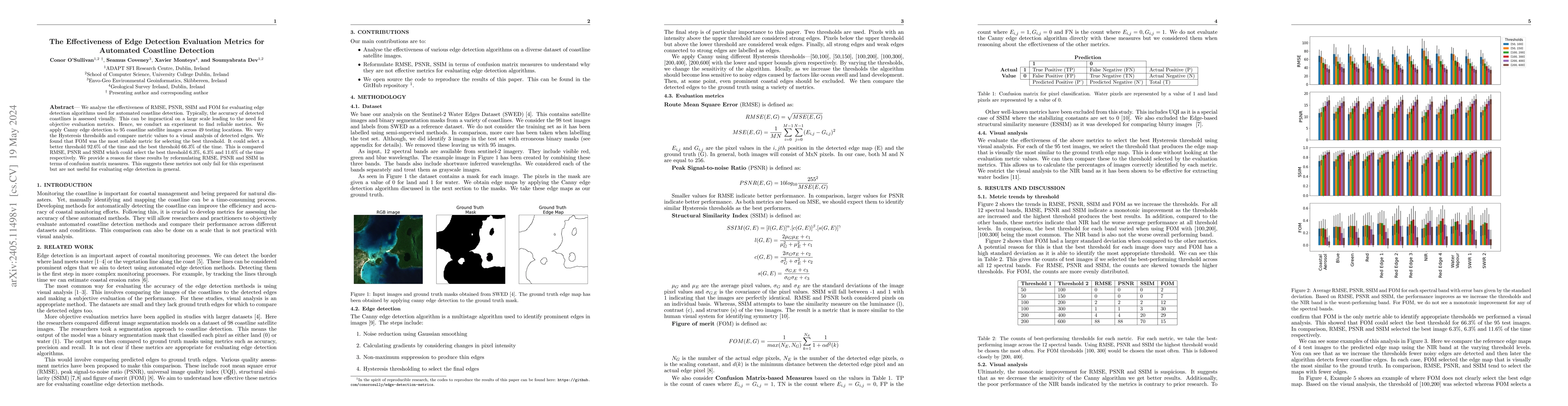
We analyse the effectiveness of RMSE, PSNR, SSIM and FOM for evaluating edge detection algorithms used for automated coastline detection. Typically, the accuracy of detected coastlines is assessed v...
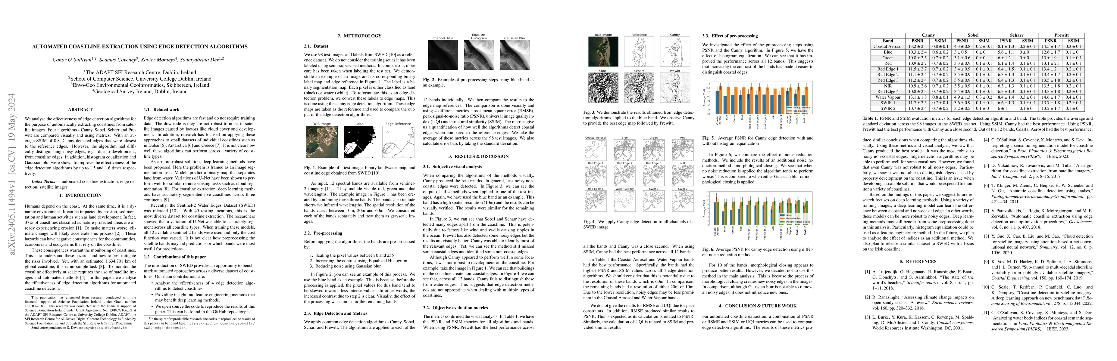
We analyse the effectiveness of edge detection algorithms for the purpose of automatically extracting coastlines from satellite images. Four algorithms - Canny, Sobel, Scharr and Prewitt are compare...
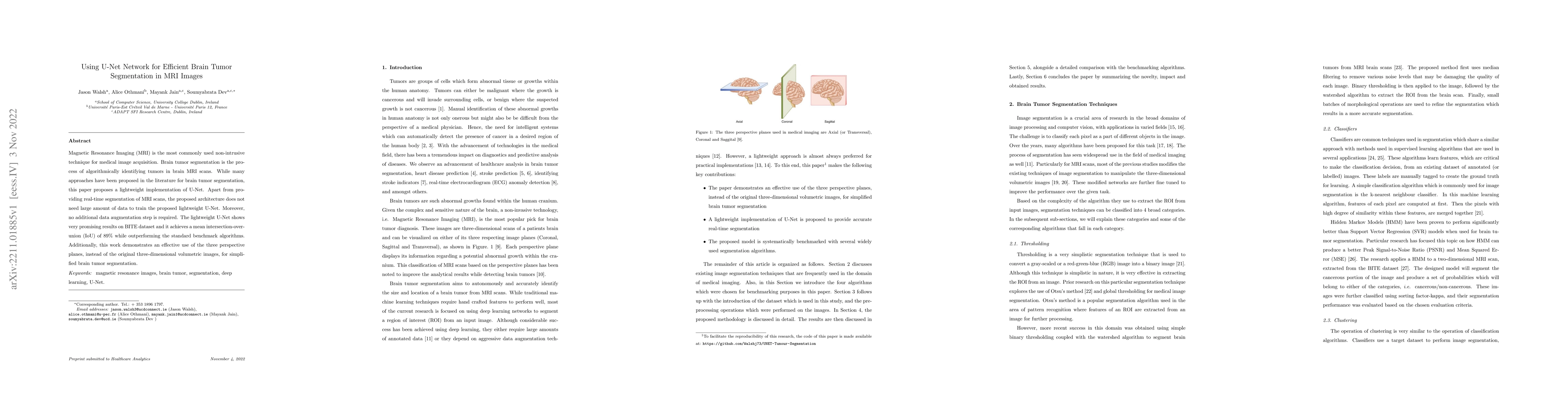
Magnetic Resonance Imaging (MRI) is the most commonly used non-intrusive technique for medical image acquisition. Brain tumor segmentation is the process of algorithmically identifying tumors in bra...
Climate science has become more ambitious in recent years as global awareness about the environment has grown. To better understand climate, historical climate (e.g. archived meteorological variable...
Ground-based sky imagers (GSIs) are increasingly becoming popular amongst the remote sensing analysts. This is because such imagers offer fantastic alternatives to satellite measurements for the pur...
In a decentralized household energy system comprised of various devices such as home appliances, electric vehicles, and solar panels, end-users are able to dig deeper into the system's details and f...
Air pollutants have long been known to cause major health problems across humans and all living organisms. Apart from that, they also play a crucial role in temperature inversion situations in the a...
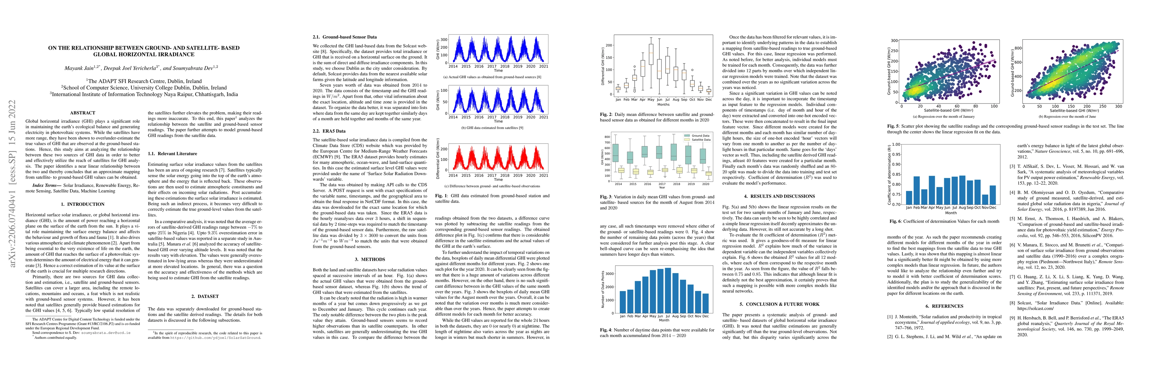
Global horizontal irradiance (GHI) plays a significant role in maintaining the earth's ecological balance and generating electricity in photovoltaic systems. While the satellites have more range, th...
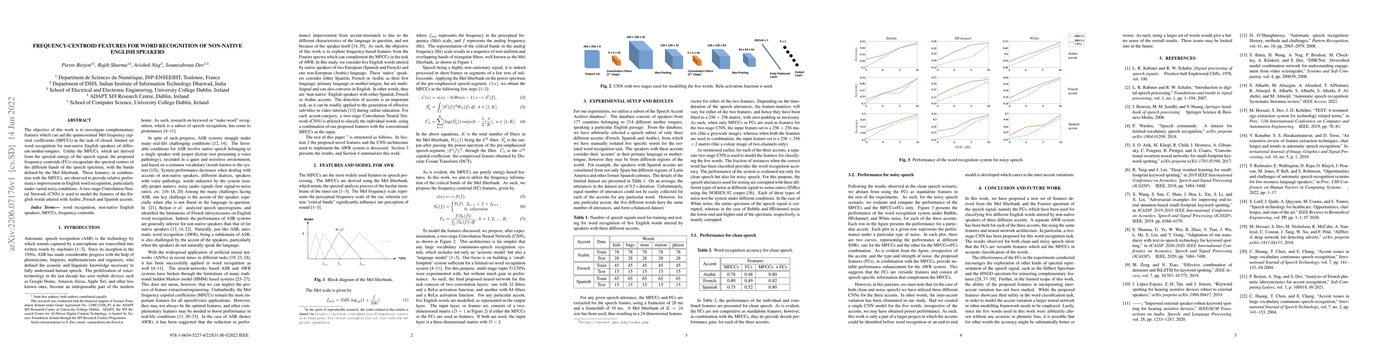
The objective of this work is to investigate complementary features which can aid the quintessential Mel frequency cepstral coefficients (MFCCs) in the task of closed, limited set word recognition f...
Heart Disease has become one of the most serious diseases that has a significant impact on human life. It has emerged as one of the leading causes of mortality among the people across the globe duri...
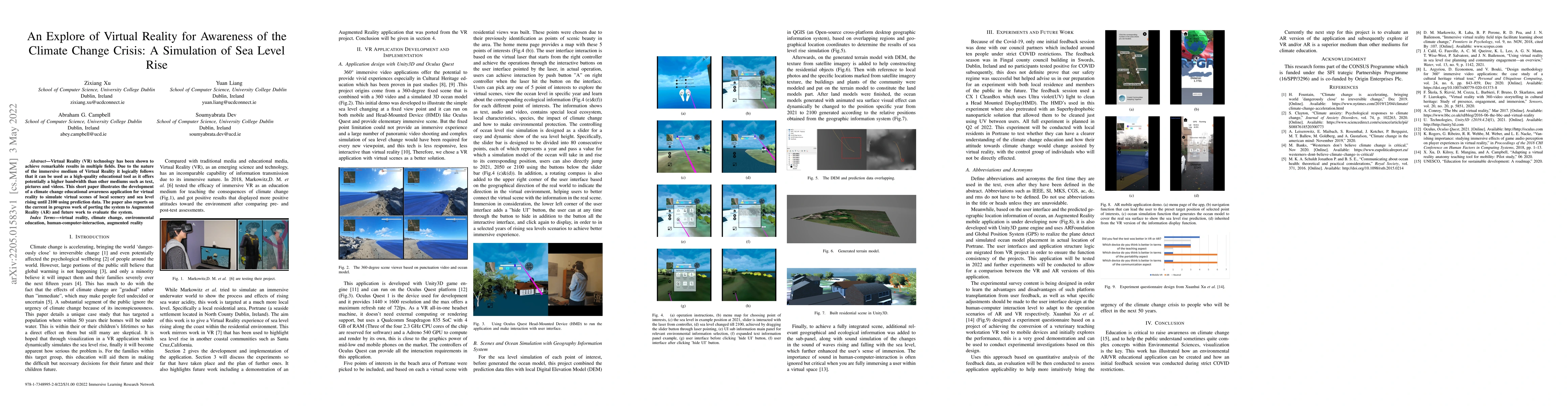
Virtual Reality (VR) technology has been shown to achieve remarkable results in multiple fields. Due to the nature of the immersive medium of Virtual Reality it logically follows that it can be used...
The reliability of ERA5 satellite-based air temperature data is under investigation in this paper. To evaluate this, the ERA5 data will be compared with land-based data obtained from weather station...
Engagement is an essential indicator of the Quality-of-Learning Experience (QoLE) and plays a major role in developing intelligent educational interfaces. The number of people learning through Massi...
Air pollution has been on continuous rise with increase in industrialization in metropolitan cities of the world. Several measures including strict climate laws and reduction in the number of vehicl...
The negative impact of stroke in society has led to concerted efforts to improve the management and diagnosis of stroke. With an increased synergy between technology and medical diagnosis, caregiver...
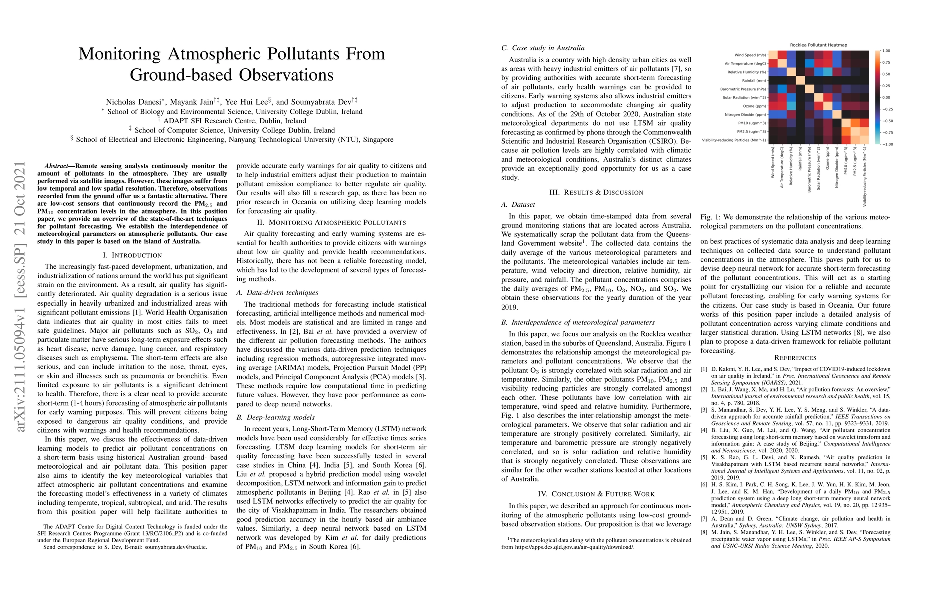
Remote sensing analysts continuously monitor the amount of pollutants in the atmosphere. They are usually performed via satellite images. However, these images suffer from low temporal and low spati...
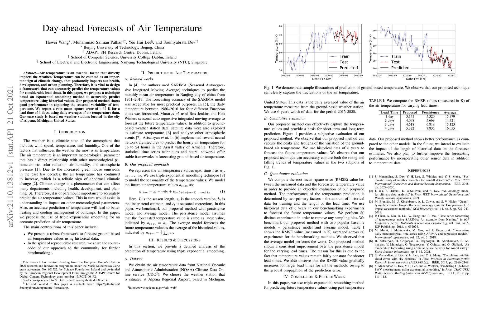
Air temperature is an essential factor that directly impacts the weather. Temperature can be counted as an important sign of climatic change, that profoundly impacts our health, development, and urb...
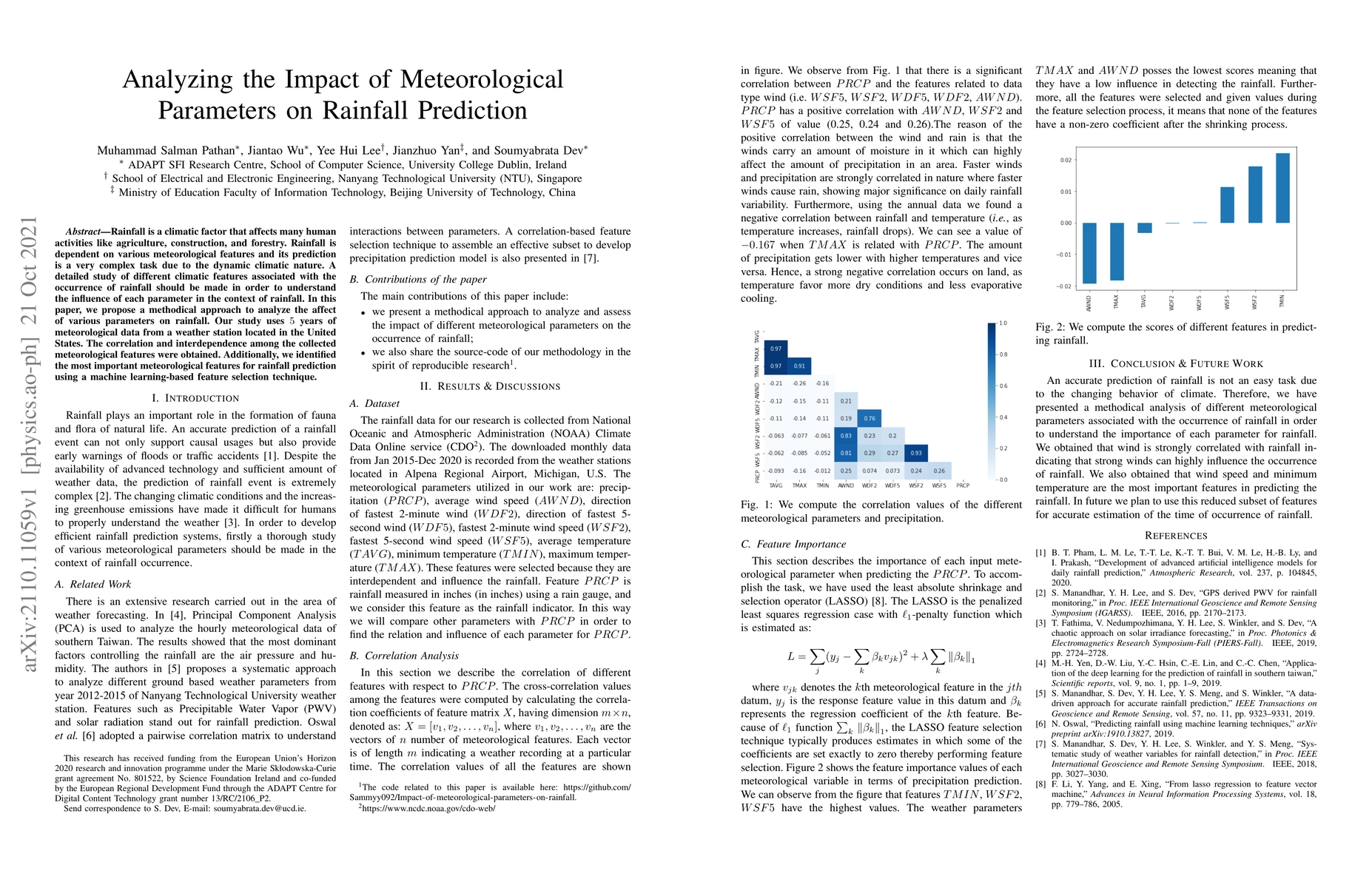
Rainfall is a climatic factor that affects many human activities like agriculture, construction, and forestry. Rainfall is dependent on various meteorological features and its prediction is a very c...
The FAIR (Findable, Accessible, Interoperable, Reusable) data principles are fundamental for climate researchers and all stakeholders in the current digital ecosystem. In this paper, we demonstrate ...
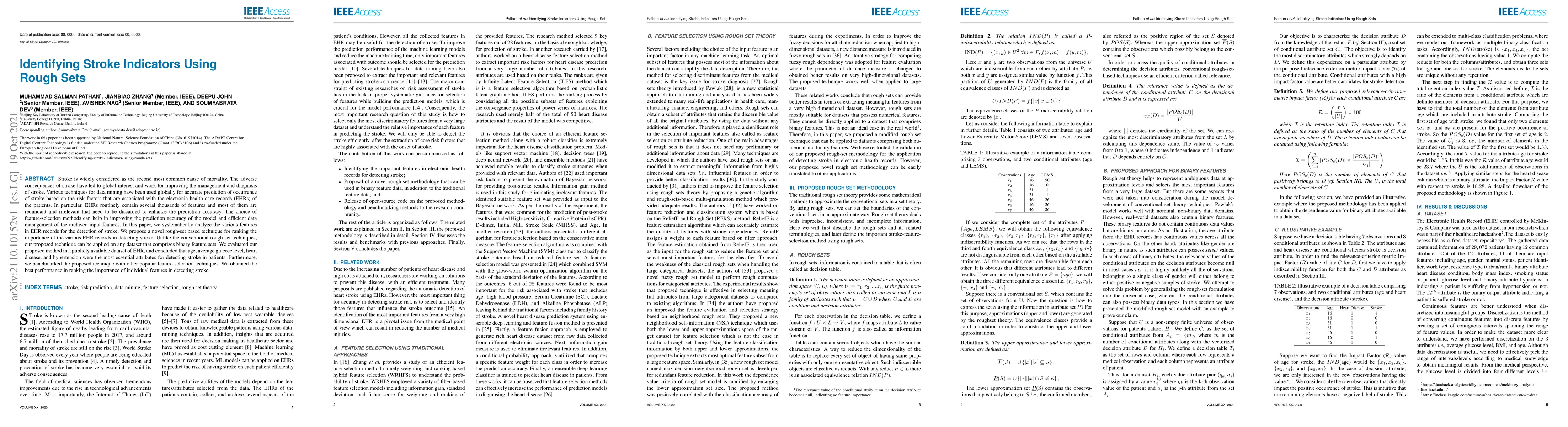
Stroke is widely considered as the second most common cause of mortality. The adverse consequences of stroke have led to global interest and work for improving the management and diagnosis of stroke...
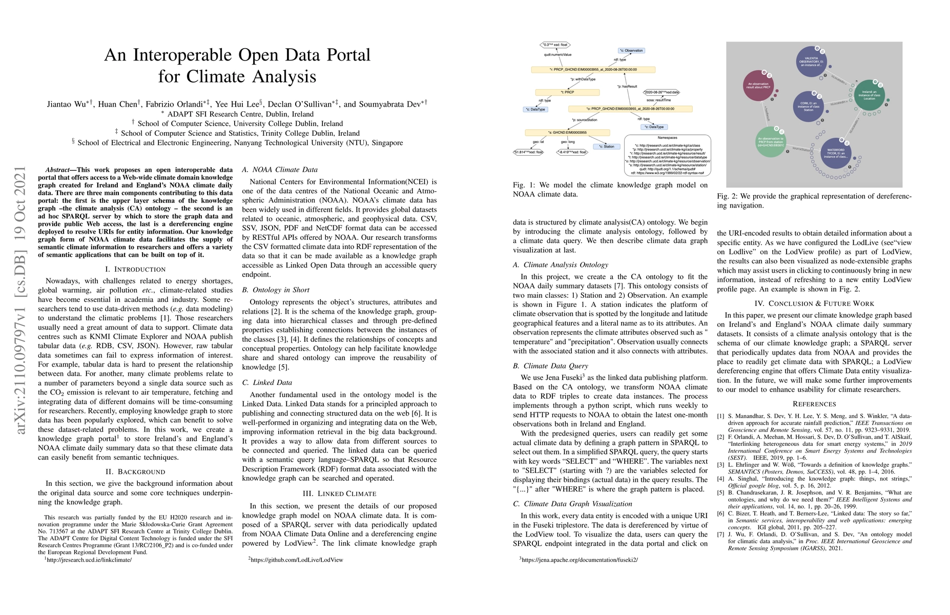
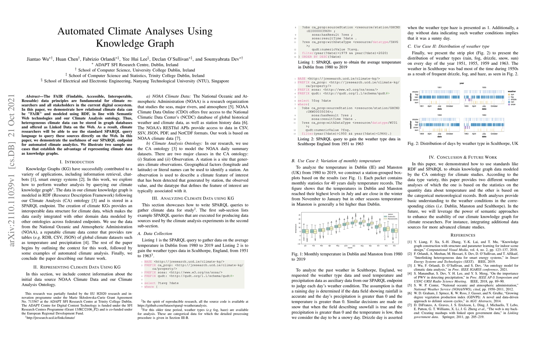
This work proposes an open interoperable data portal that offers access to a Web-wide climate domain knowledge graph created for Ireland and England's NOAA climate daily data. There are three main c...
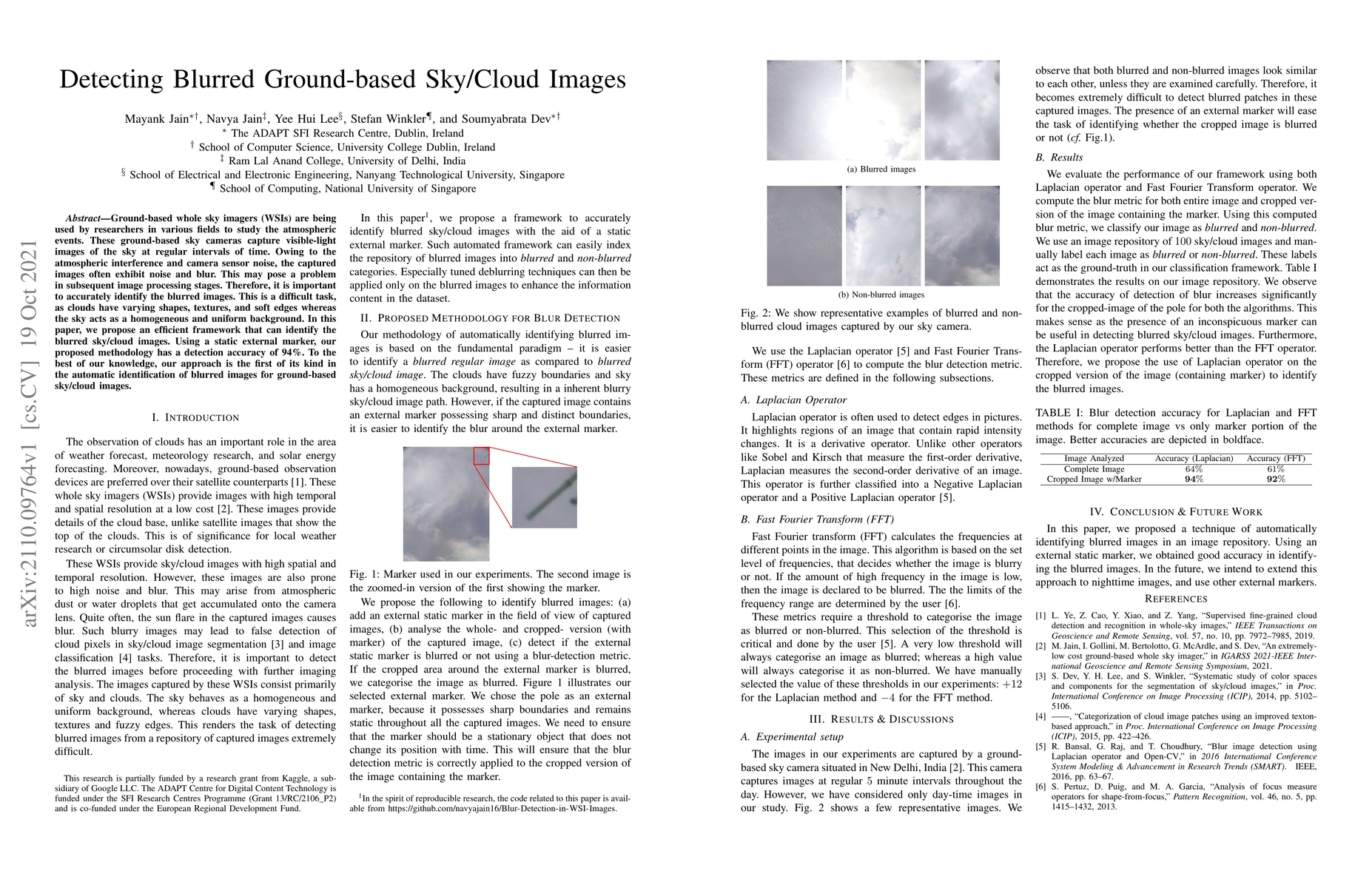
Ground-based whole sky imagers (WSIs) are being used by researchers in various fields to study the atmospheric events. These ground-based sky cameras capture visible-light images of the sky at regul...
In this paper, we demonstrate the importance of embedding temporal information for an accurate prediction of solar irradiance. We have used two sets of models for forecasting solar irradiance. The f...
In this paper, we introduce a novel graph-based method to classify the regions with similar climate in a local area. We refer our proposed method as Graph Partition Based Method (GPBM). Our proposed...
Speech recognition systems have made tremendous progress since the last few decades. They have developed significantly in identifying the speech of the speaker. However, there is a scope of improvem...
In a decentralized household energy system consisting of various devices such as washing machines, heat pumps, and solar panels, understanding the electric energy consumption and production data at ...
With the inclusion of smart meters, electricity load consumption data can be fetched for individual consumer buildings at high temporal resolutions. Availability of such data has made it possible to...
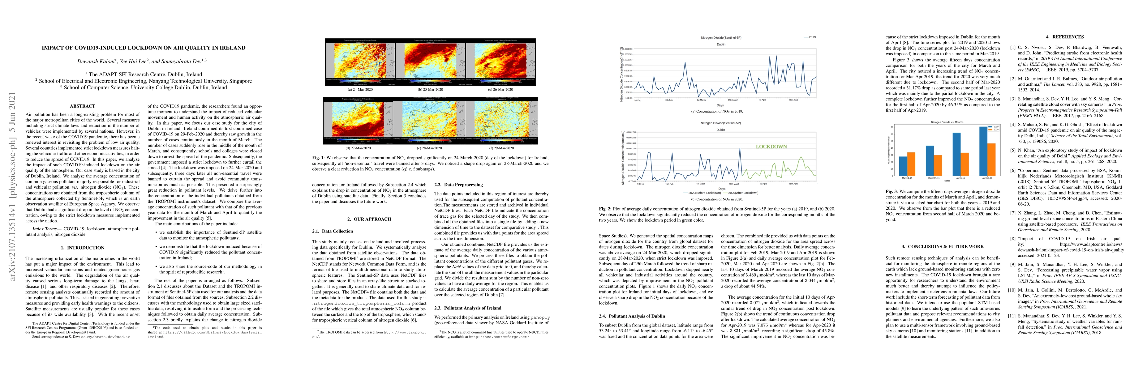
Air pollution has been a long-existing problem for most of the major metropolitan cities of the world. Several measures including strict climate laws and reduction in the number of vehicles were imp...
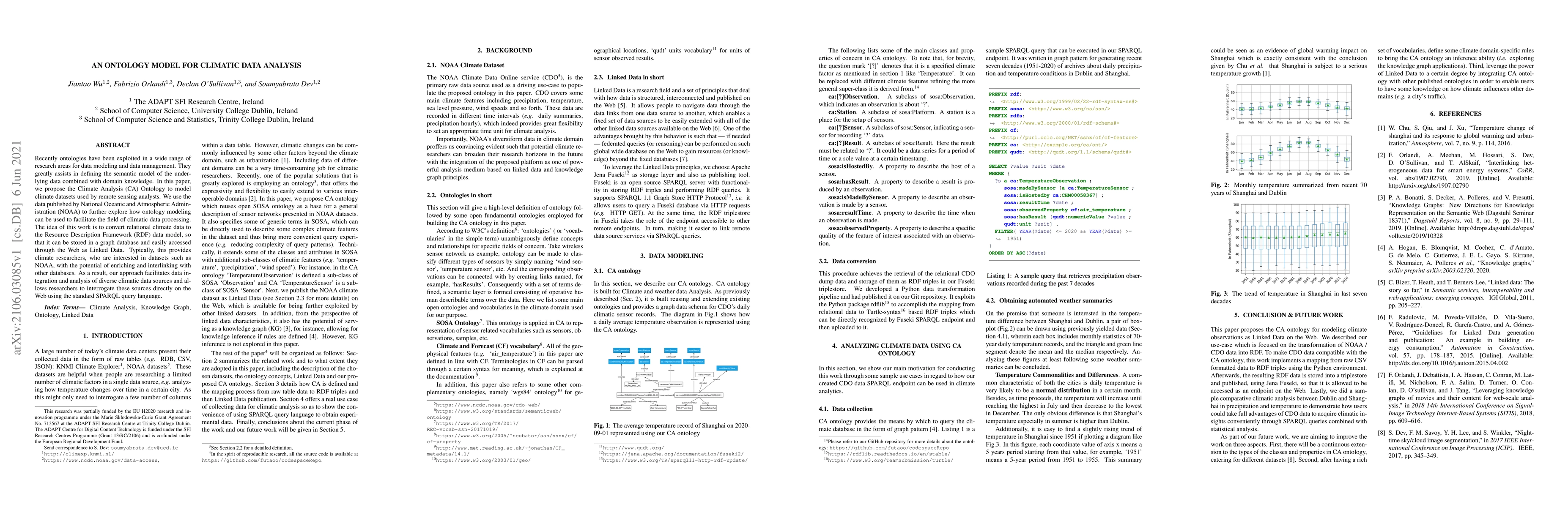
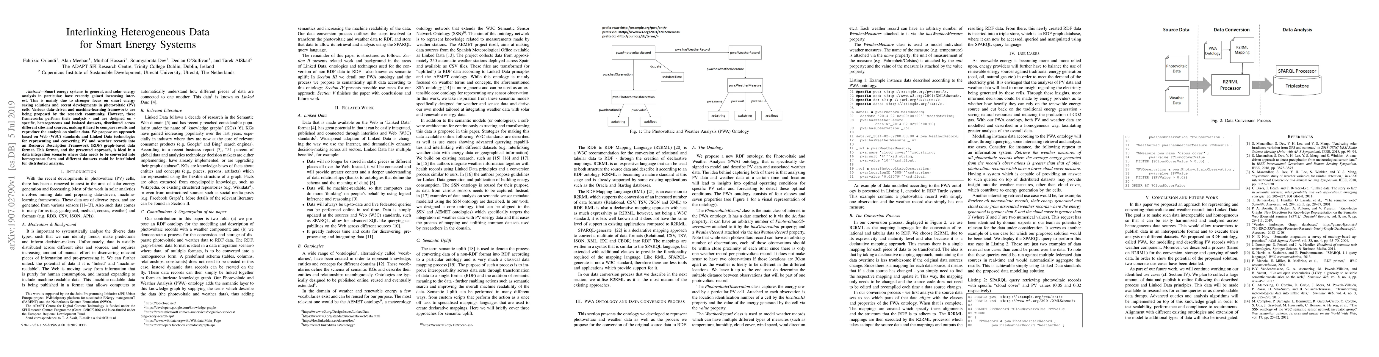
Recently ontologies have been exploited in a wide range of research areas for data modeling and data management. They greatly assists in defining the semantic model of the underlying data combined w...

Ground-based Whole Sky Imagers (WSIs) are increasingly being used for various remote sensing applications. While the fundamental requirements of a WSI are to make it climate-proof with an ability to...
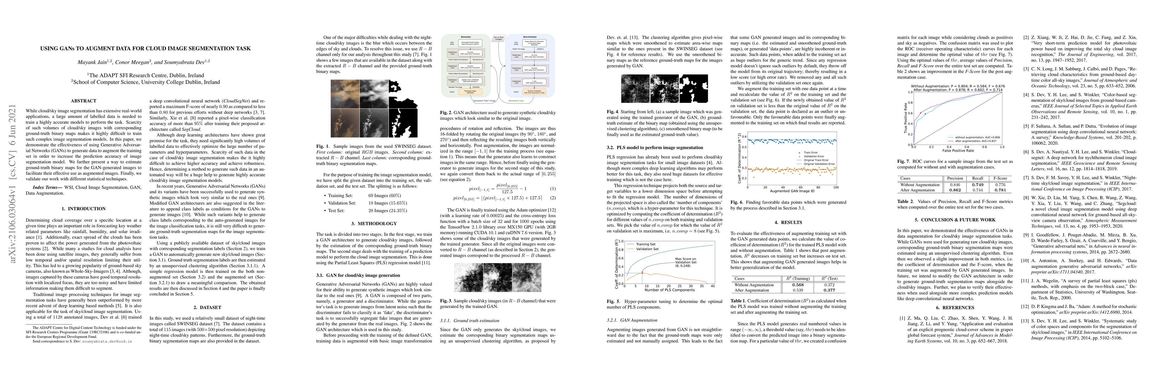
While cloud/sky image segmentation has extensive real-world applications, a large amount of labelled data is needed to train a highly accurate models to perform the task. Scarcity of such volumes of...
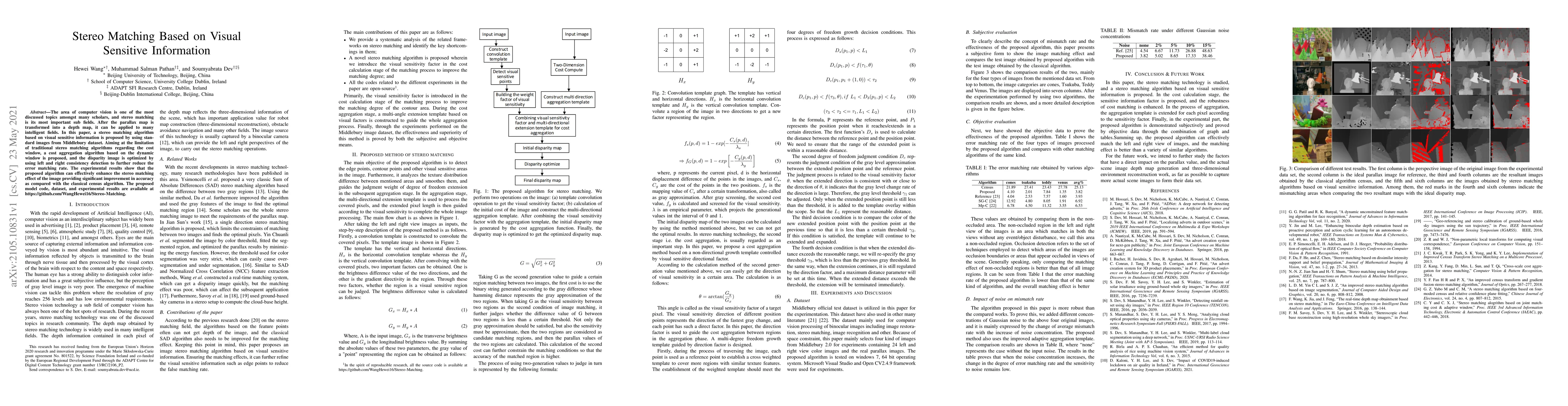
The area of computer vision is one of the most discussed topics amongst many scholars, and stereo matching is its most important sub fields. After the parallax map is transformed into a depth map, i...
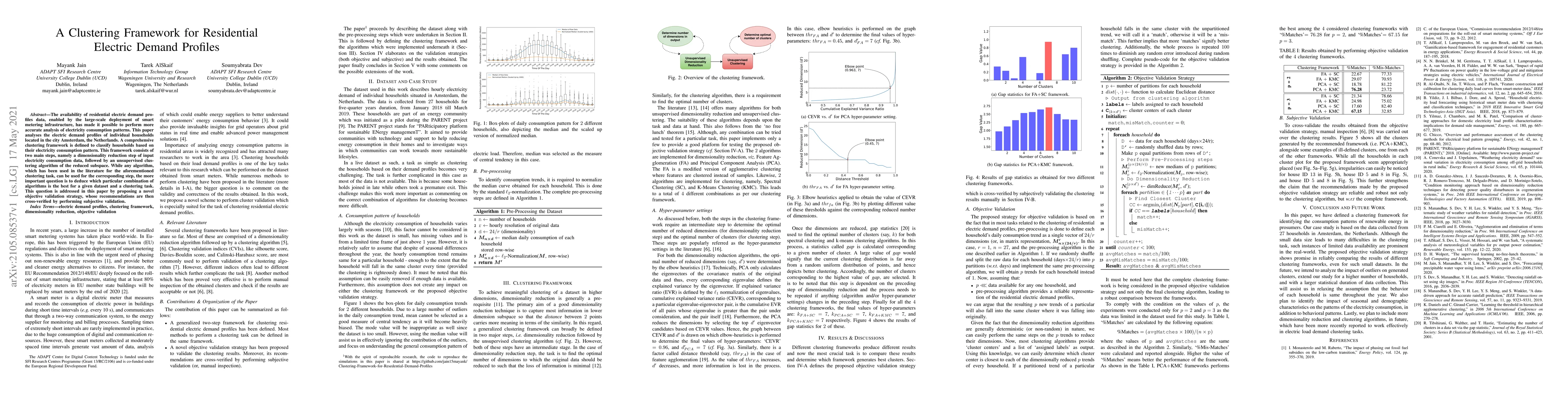
The availability of residential electric demand profiles data, enabled by the large-scale deployment of smart metering infrastructure, has made it possible to perform more accurate analysis of elect...
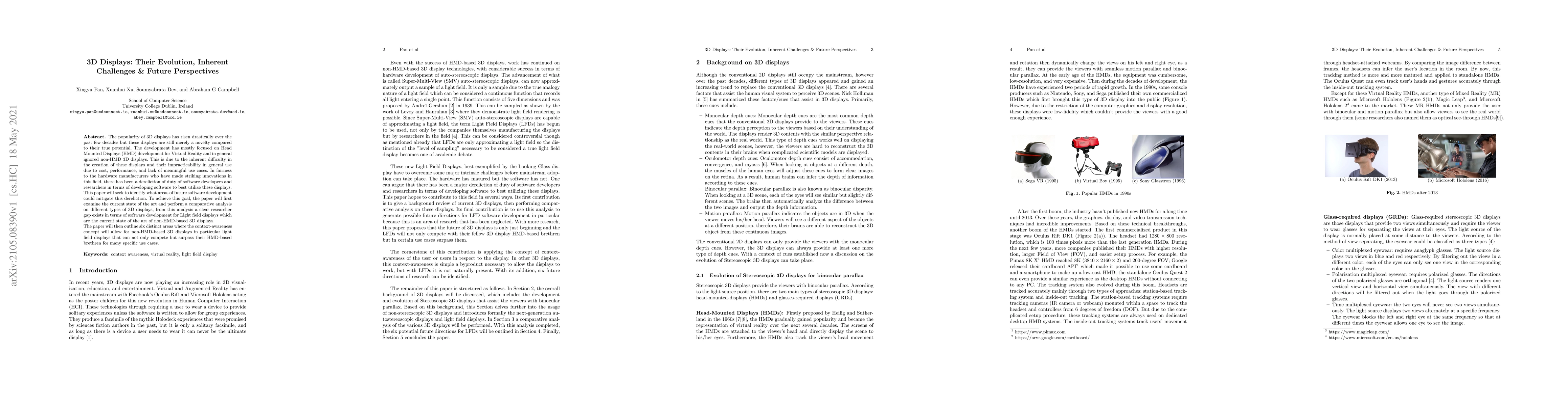
The popularity of 3D displays has risen drastically over the past few decades but these displays are still merely a novelty compared to their true potential. The development has mostly focused on He...
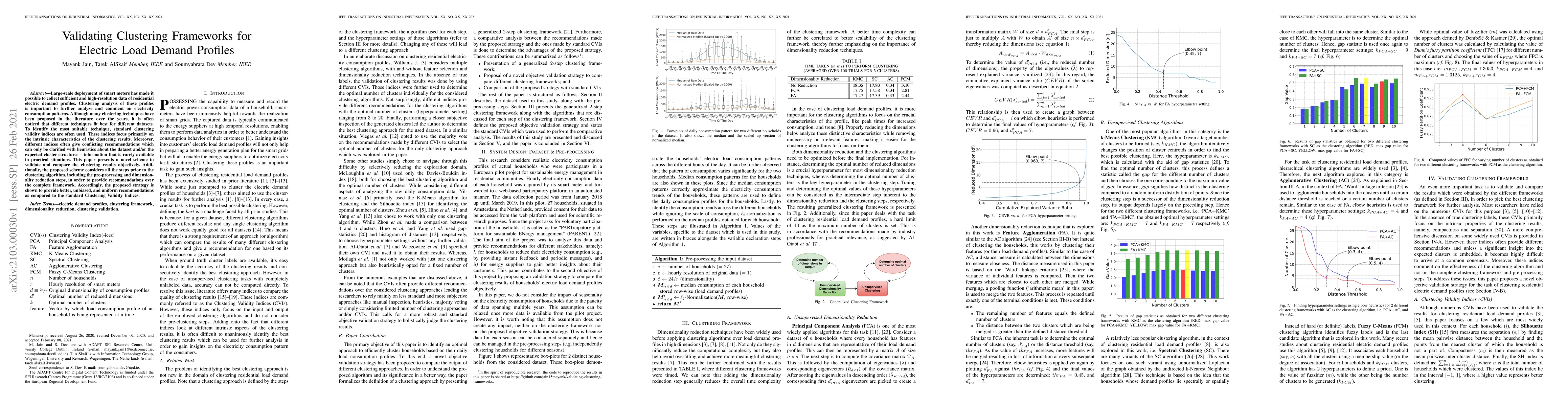
Large-scale deployment of smart meters has made it possible to collect sufficient and high-resolution data of residential electric demand profiles. Clustering analysis of these profiles is important...

With the rapid technological advancements, organizations need to rapidly scale up their information technology (IT) infrastructure viz. hardware, software, and services, at a low cost. However, the ...
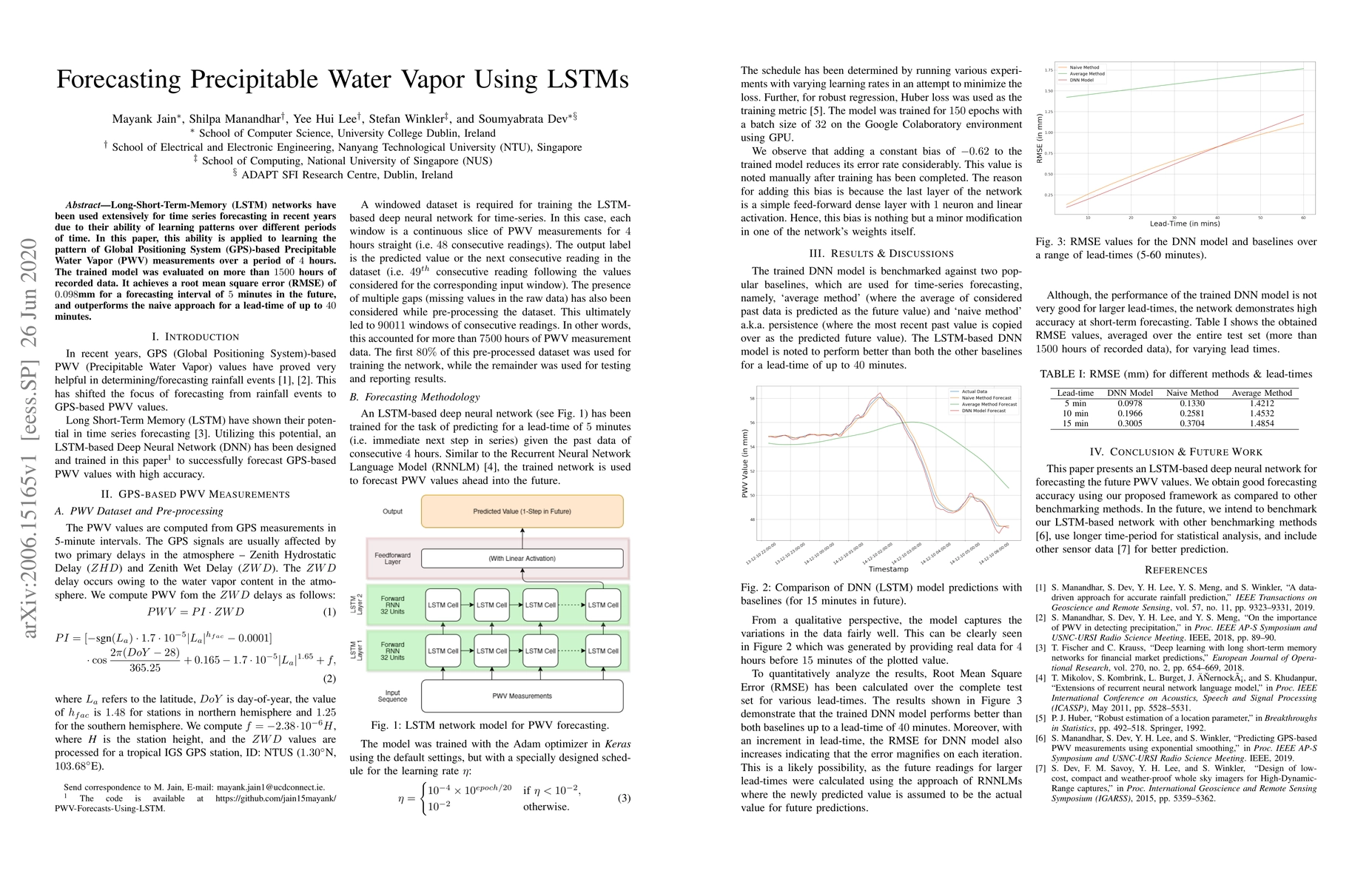
Long-Short-Term-Memory (LSTM) networks have been used extensively for time series forecasting in recent years due to their ability of learning patterns over different periods of time. In this paper,...
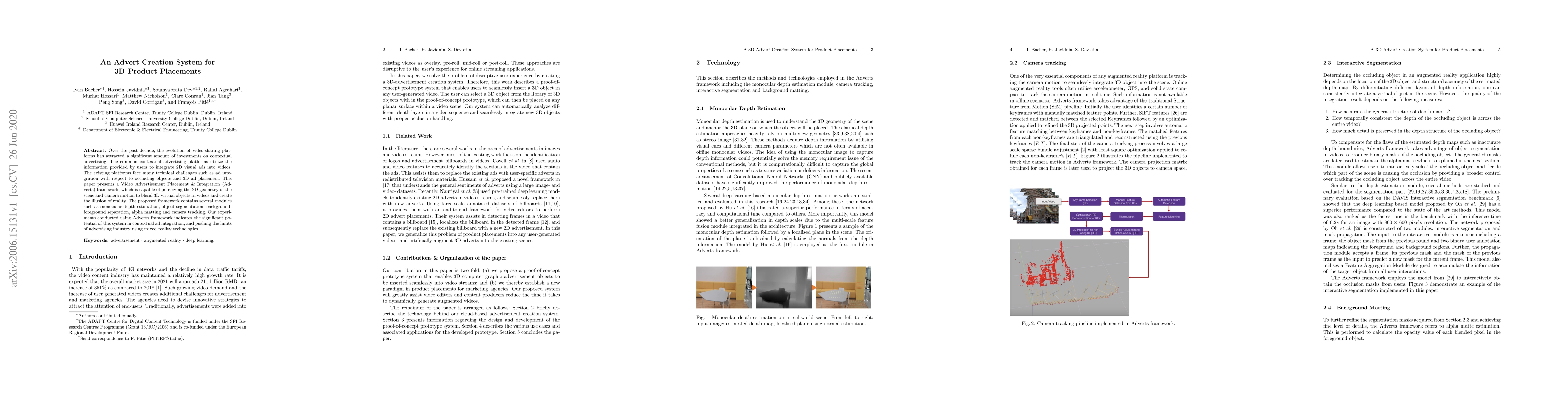
Over the past decade, the evolution of video-sharing platforms has attracted a significant amount of investments on contextual advertising. The common contextual advertising platforms utilize the in...
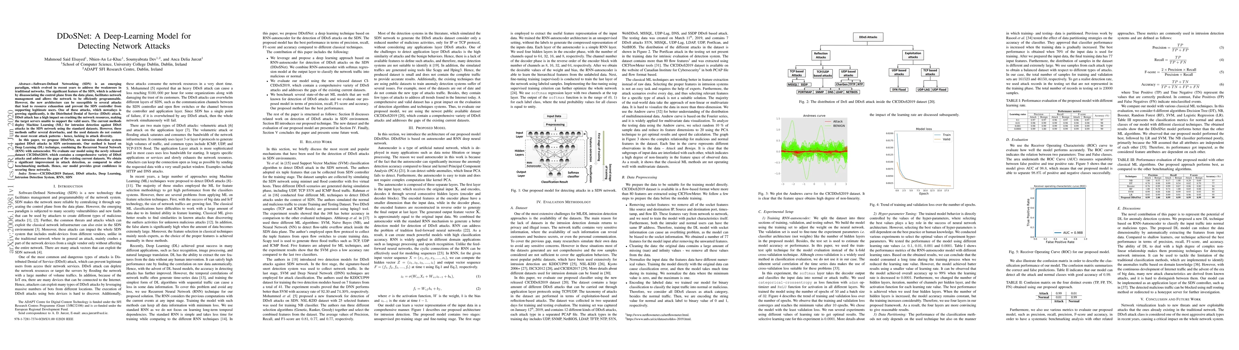
Software-Defined Networking (SDN) is an emerging paradigm, which evolved in recent years to address the weaknesses in traditional networks. The significant feature of the SDN, which is achieved by d...
Image quality assessment is critical to control and maintain the perceived quality of visual content. Both subjective and objective evaluations can be utilised, however, subjective image quality ass...
Solar irradiance is the primary input for all solar energy generation systems. The amount of available solar radiation over time under the local weather conditions helps to decide the optimal locati...
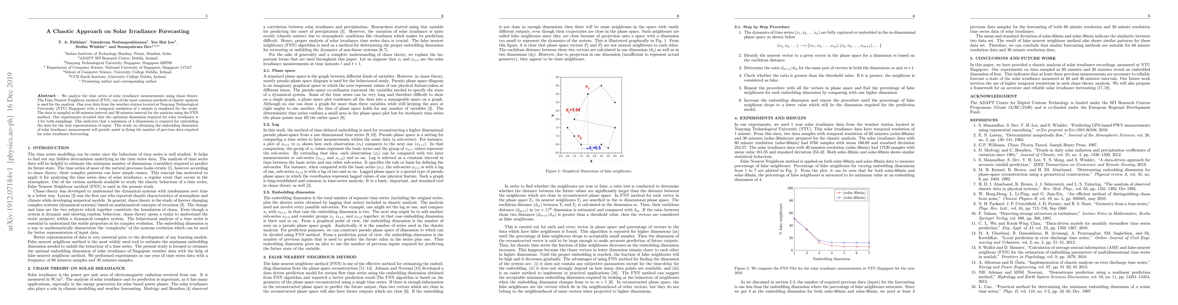
We analyse the time series of solar irradiance measurements using chaos theory. The False Nearest Neighbour method (FNN), one of the most common methods of chaotic analysis is used for the analysis....
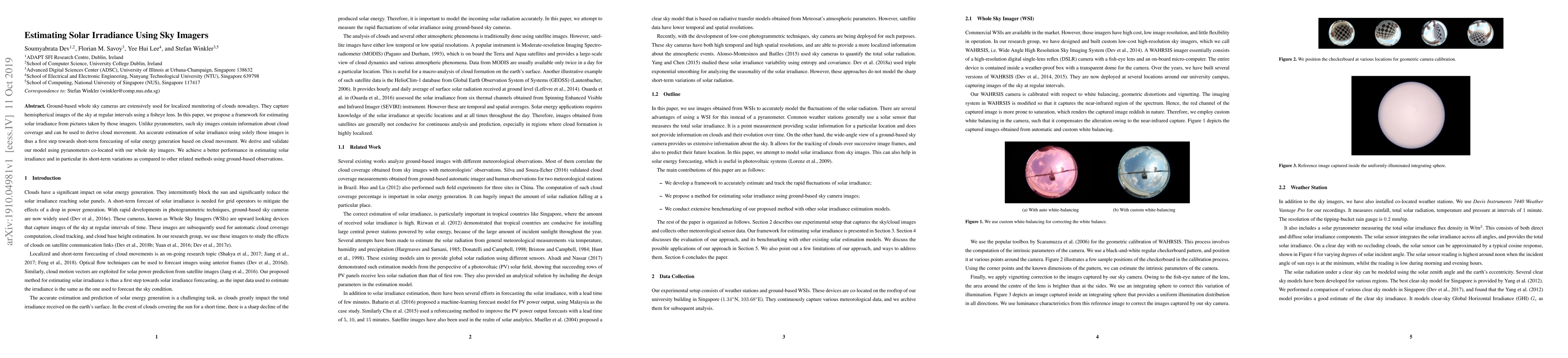
Ground-based whole sky cameras are extensively used for localized monitoring of clouds nowadays. They capture hemispherical images of the sky at regular intervals using a fisheye lens. In this paper...
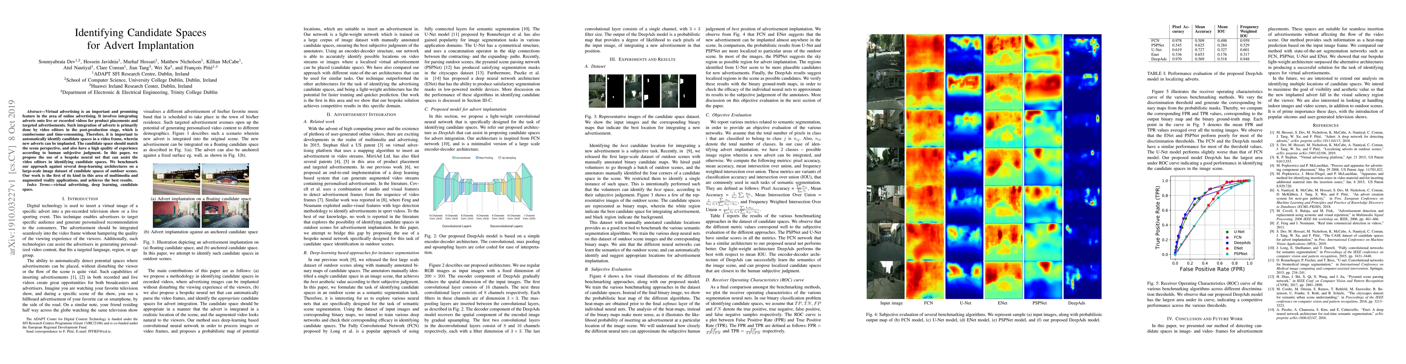
Virtual advertising is an important and promising feature in the area of online advertising. It involves integrating adverts onto live or recorded videos for product placements and targeted advertis...
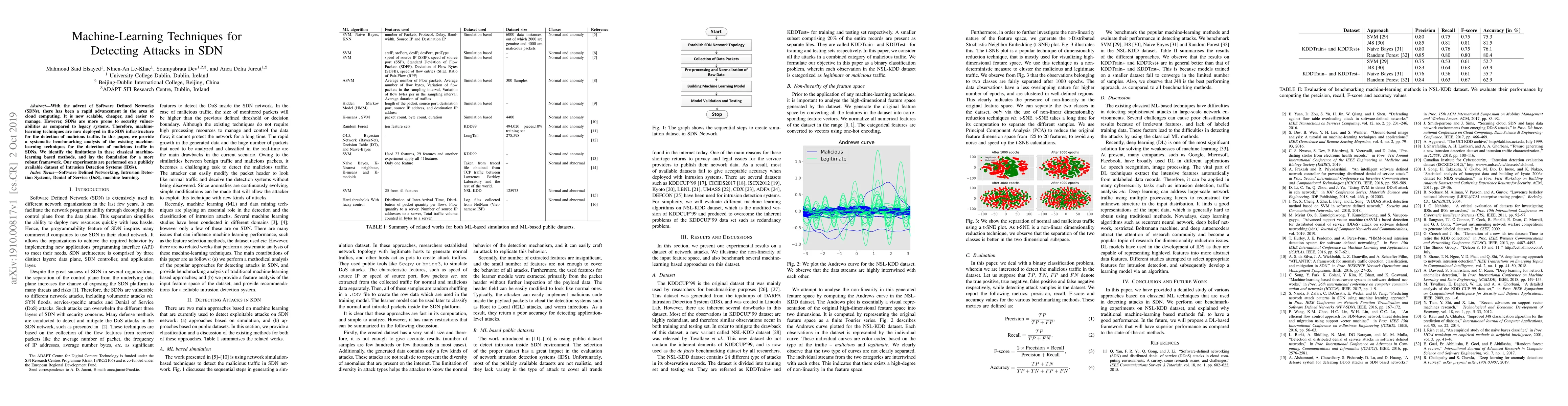
With the advent of Software Defined Networks (SDNs), there has been a rapid advancement in the area of cloud computing. It is now scalable, cheaper, and easier to manage. However, SDNs are more pron...
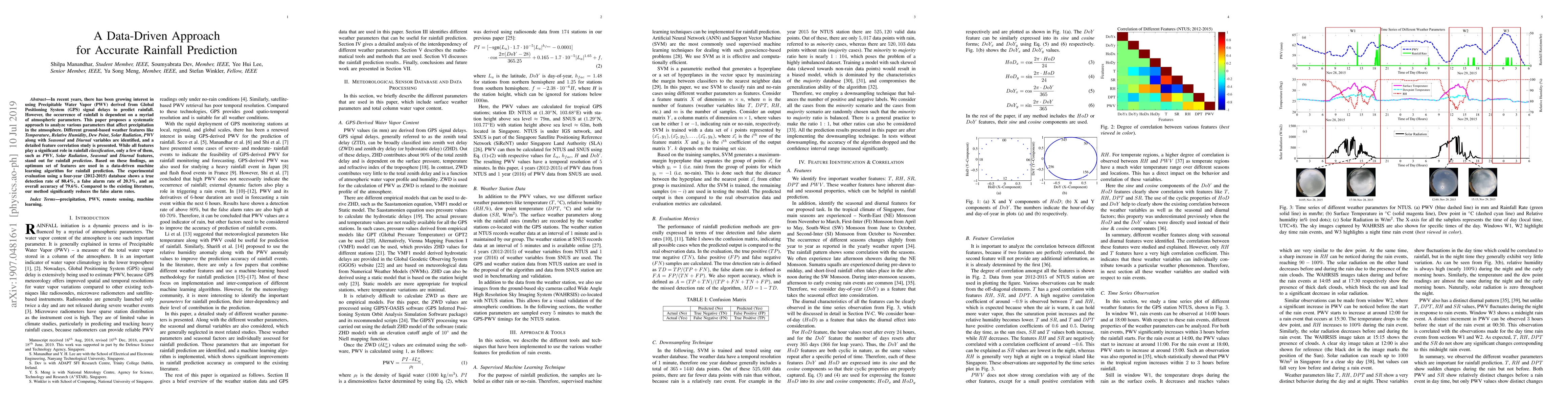
In recent years, there has been growing interest in using Precipitable Water Vapor (PWV) derived from Global Positioning System (GPS) signal delays to predict rainfall. However, the occurrence of ra...
Smart energy systems in general, and solar energy analysis in particular, have recently gained increasing interest. This is mainly due to stronger focus on smart energy saving solutions and recent d...
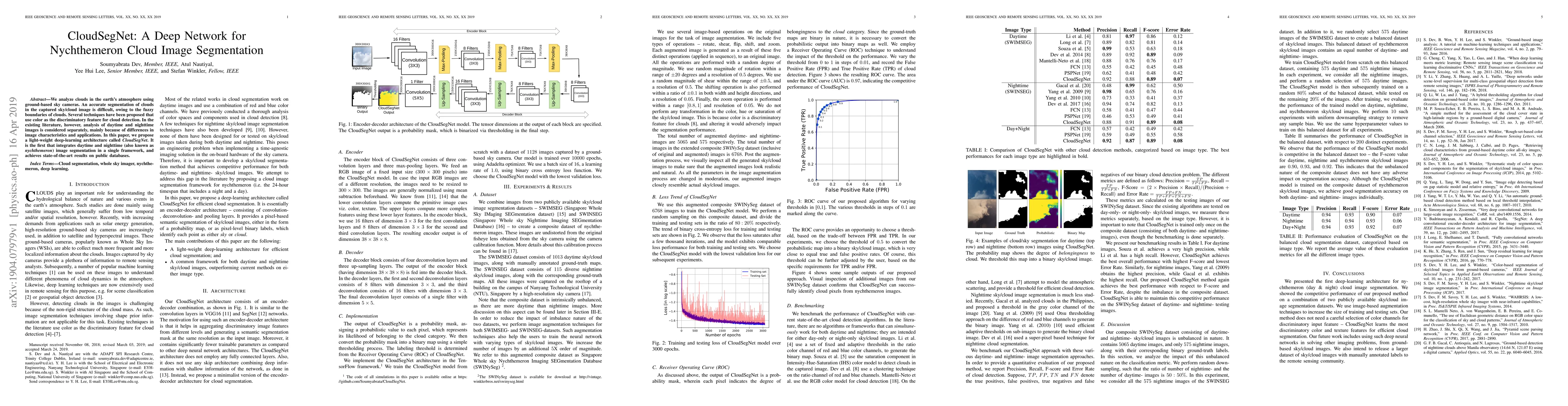
We analyze clouds in the earth's atmosphere using ground-based sky cameras. An accurate segmentation of clouds in the captured sky/cloud image is difficult, owing to the fuzzy boundaries of clouds. ...
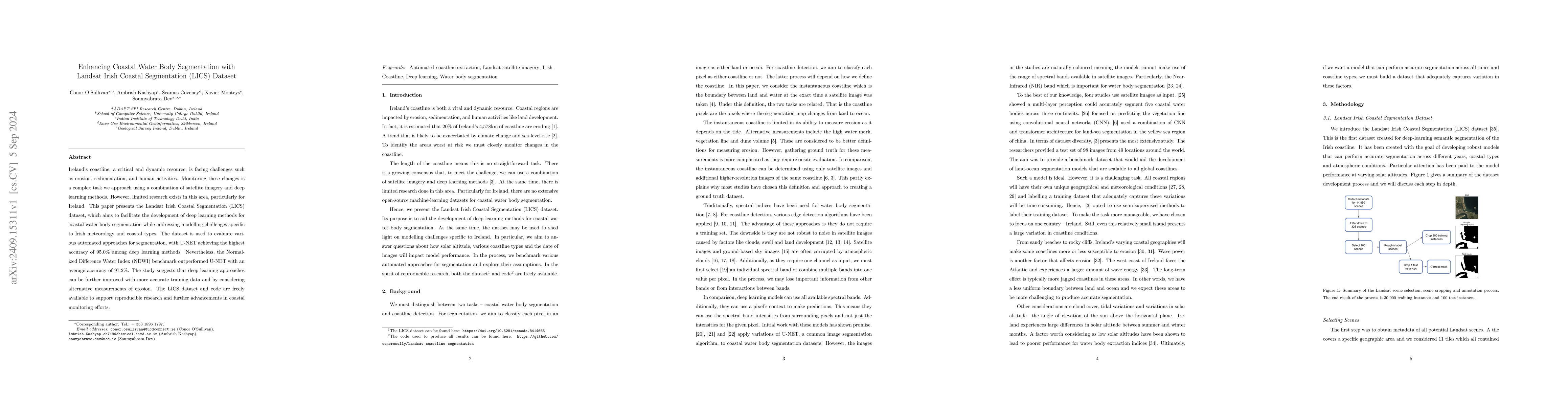
Ireland's coastline, a critical and dynamic resource, is facing challenges such as erosion, sedimentation, and human activities. Monitoring these changes is a complex task we approach using a combinat...
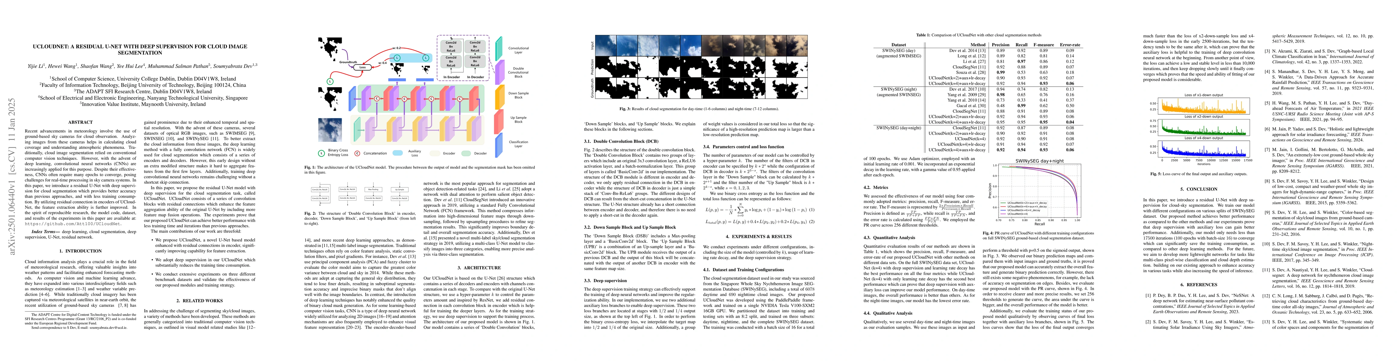
Recent advancements in meteorology involve the use of ground-based sky cameras for cloud observation. Analyzing images from these cameras helps in calculating cloud coverage and understanding atmosphe...
Cloud segmentation amounts to separating cloud pixels from non-cloud pixels in an image. Current deep learning methods for cloud segmentation suffer from three issues. (a) Constrain on their receptive...
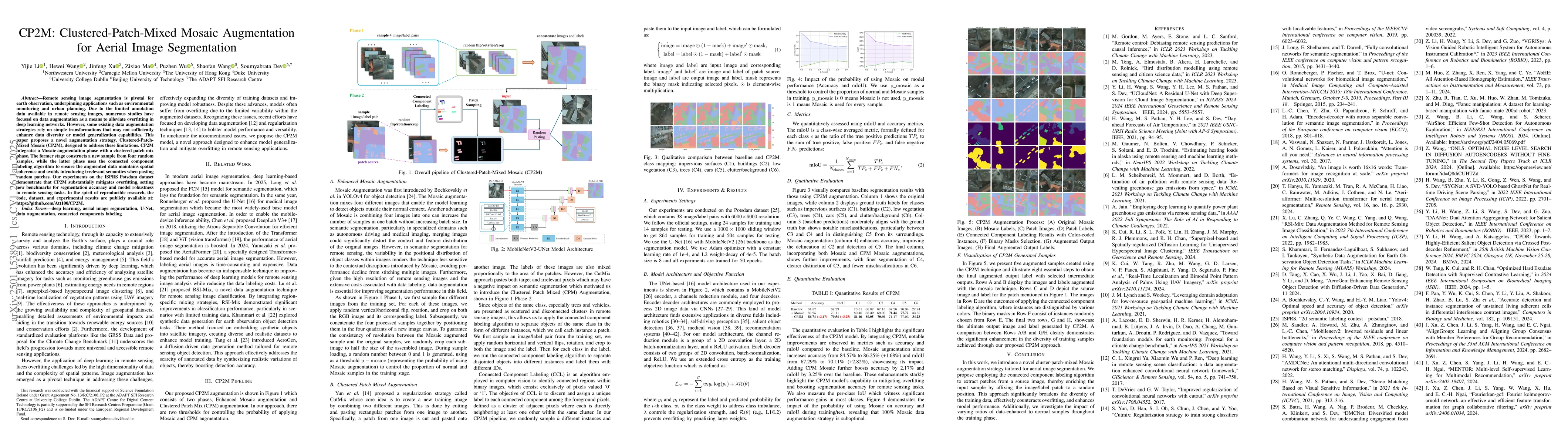
Remote sensing image segmentation is pivotal for earth observation, underpinning applications such as environmental monitoring and urban planning. Due to the limited annotation data available in remot...
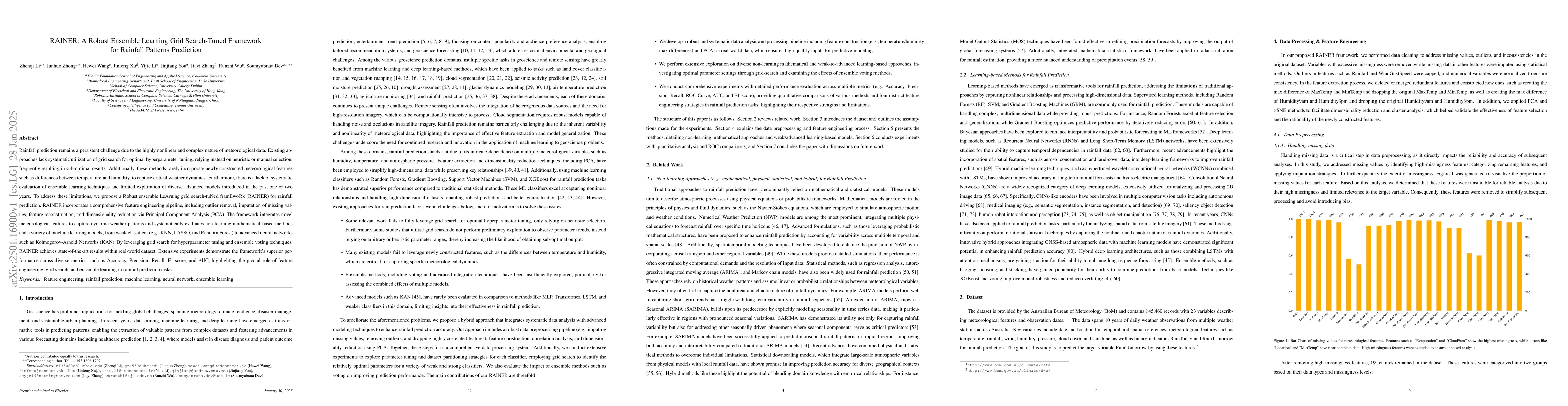
Rainfall prediction remains a persistent challenge due to the highly nonlinear and complex nature of meteorological data. Existing approaches lack systematic utilization of grid search for optimal hyp...
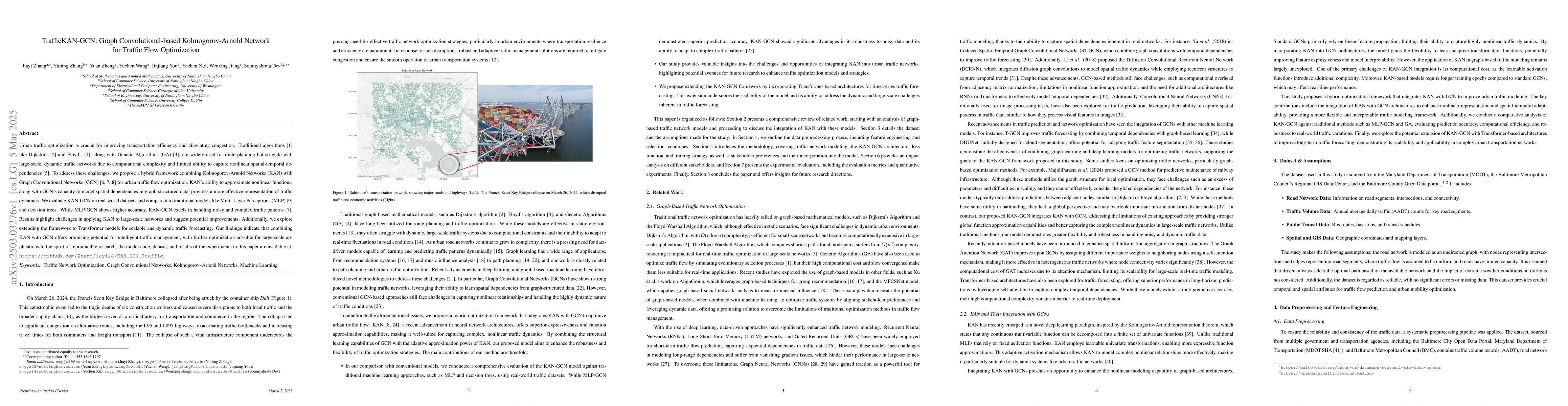
Urban traffic optimization is critical for improving transportation efficiency and alleviating congestion, particularly in large-scale dynamic networks. Traditional methods, such as Dijkstra's and Flo...

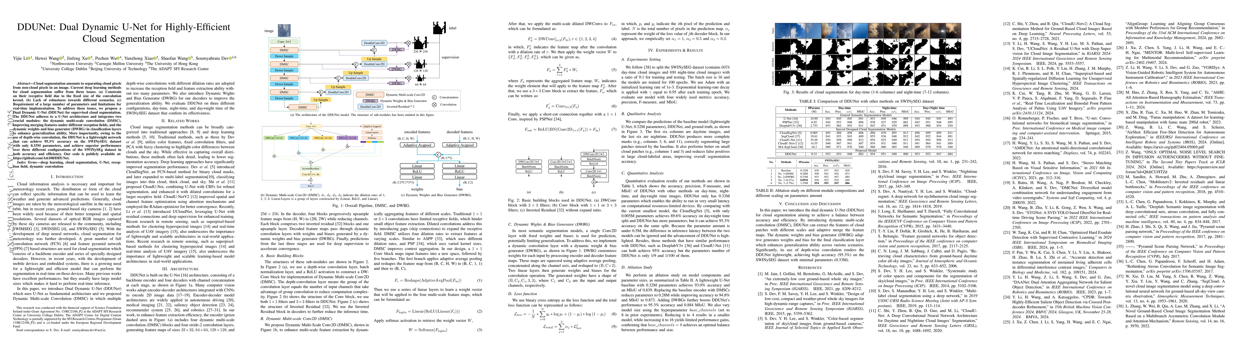
Cloud segmentation from intensity images is a pivotal task in atmospheric science and computer vision, aiding weather forecasting and climate analysis. Ground-based sky/cloud segmentation extracts clo...
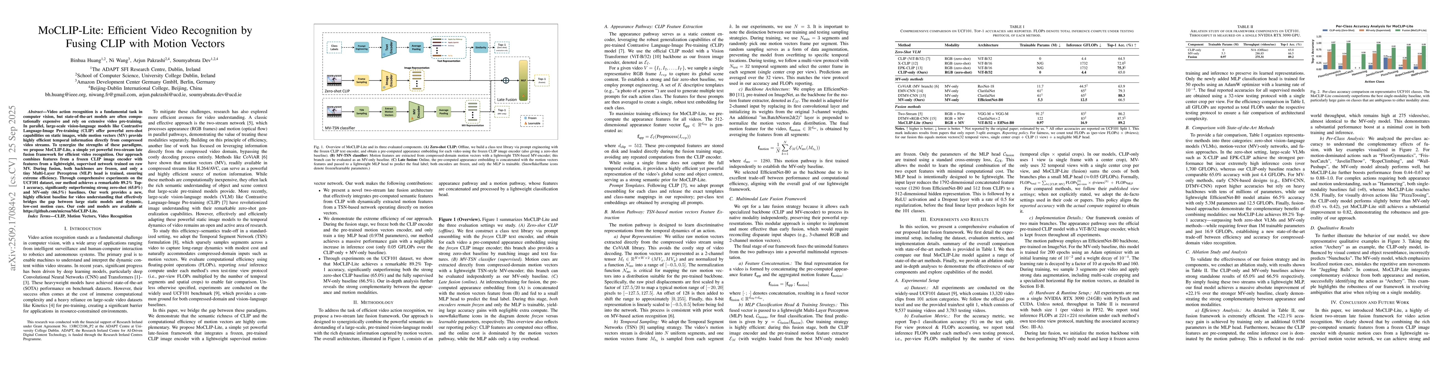
Video action recognition is a fundamental task in computer vision, but state-of-the-art models are often computationally expensive and rely on extensive video pre-training. In parallel, large-scale vi...
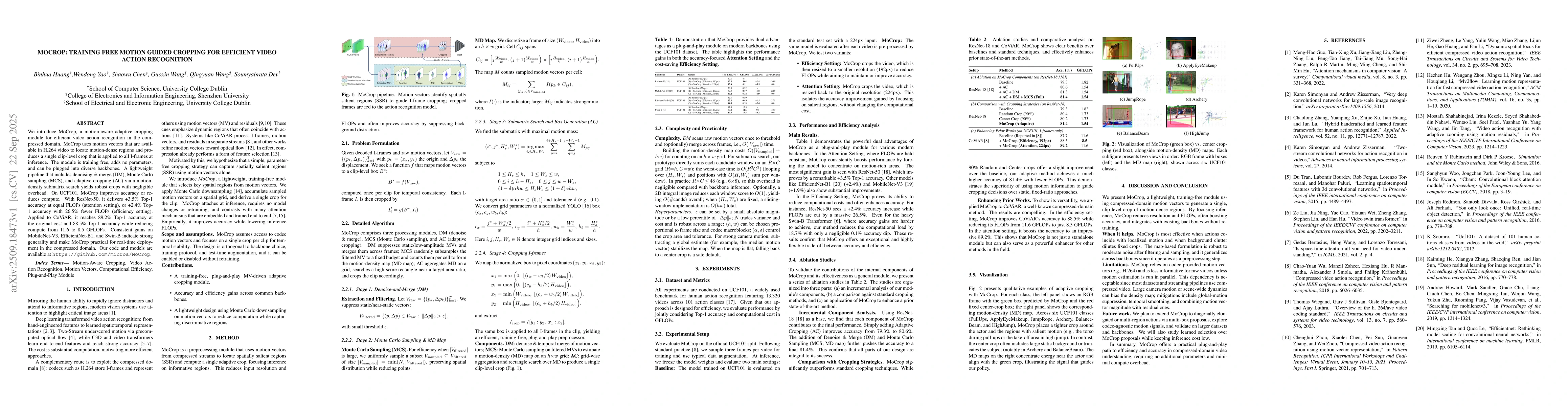
We introduce MoCrop, a motion-aware adaptive cropping module for efficient video action recognition in the compressed domain. MoCrop uses motion vectors that are available in H.264 video to locate mot...
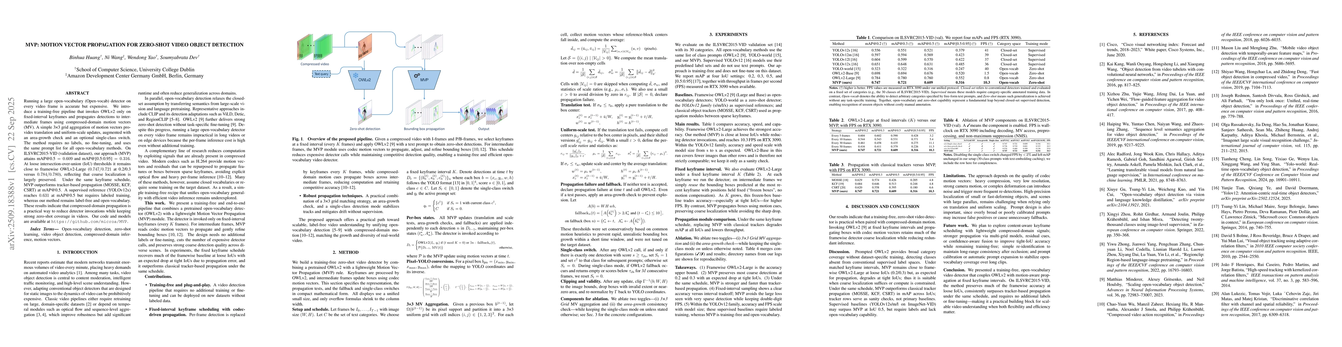
Running a large open-vocabulary (Open-vocab) detector on every video frame is accurate but expensive. We introduce a training-free pipeline that invokes OWLv2 only on fixed-interval keyframes and prop...
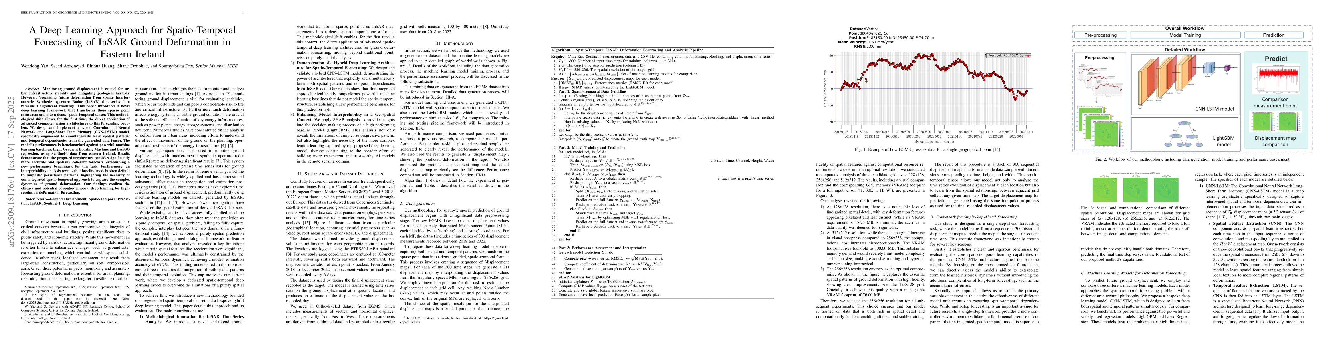
Monitoring ground displacement is crucial for urban infrastructure stability and mitigating geological hazards. However, forecasting future deformation from sparse Interferometric Synthetic Aperture R...
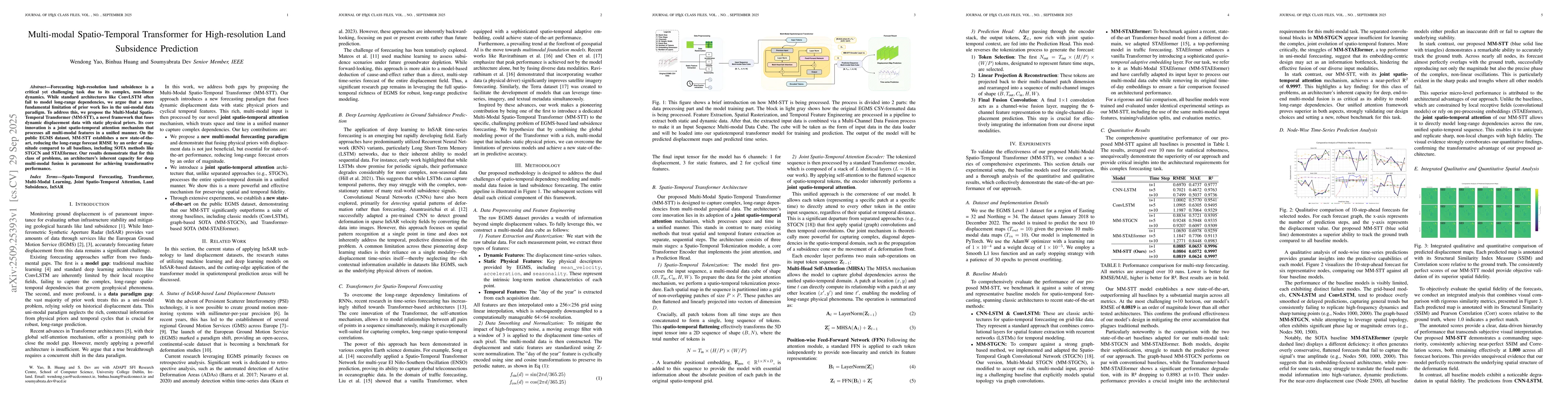
Forecasting high-resolution land subsidence is a critical yet challenging task due to its complex, non-linear dynamics. While standard architectures like ConvLSTM often fail to model long-range depend...
Near-real-time regional-scale monitoring of ground deformation is increasingly required to support urban planning, critical infrastructure management, and natural hazard mitigation. While Interferomet...
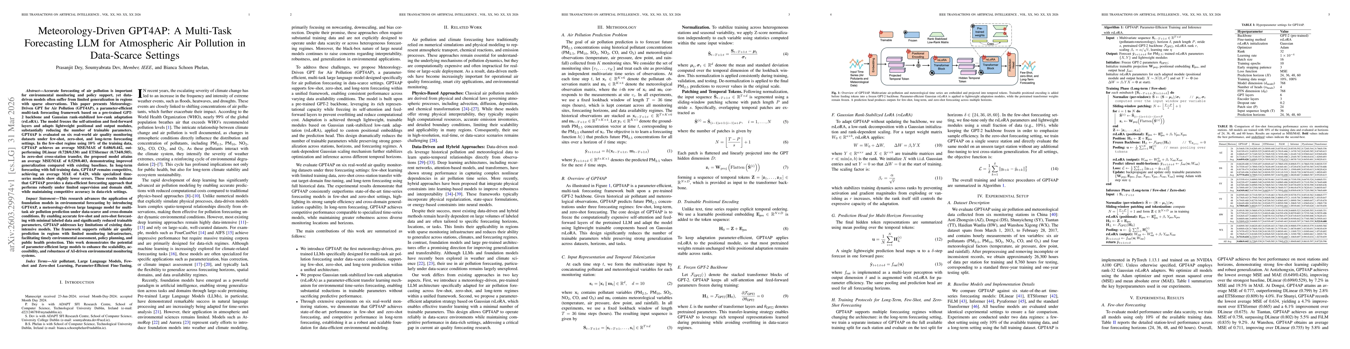
Accurate forecasting of air pollution is important for environmental monitoring and policy support, yet data-driven models often suffer from limited generalization in regions with sparse observations....
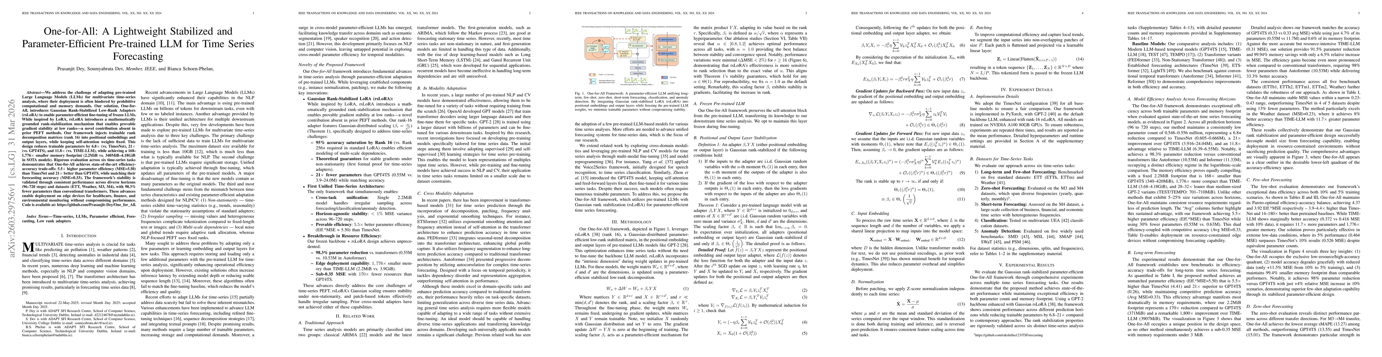
We address the challenge of adapting pre-trained Large Language Models (LLMs) for multivariate time-series analysis, where their deployment is often hindered by prohibitive computational and memory de...
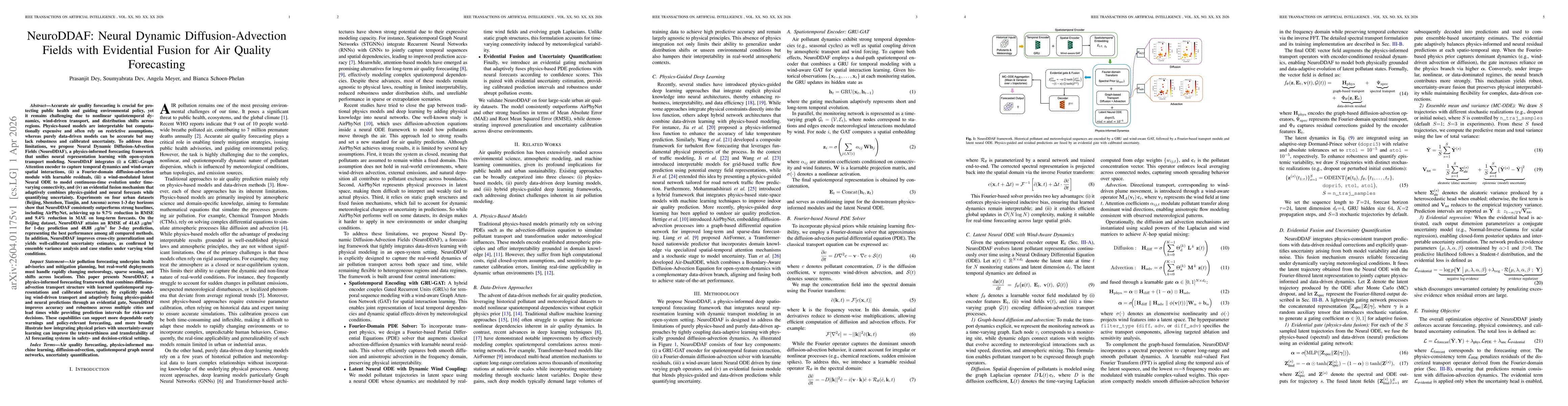
Accurate air quality forecasting is crucial for protecting public health and guiding environmental policy, yet it remains challenging due to nonlinear spatiotemporal dynamics, wind-driven transport, a...
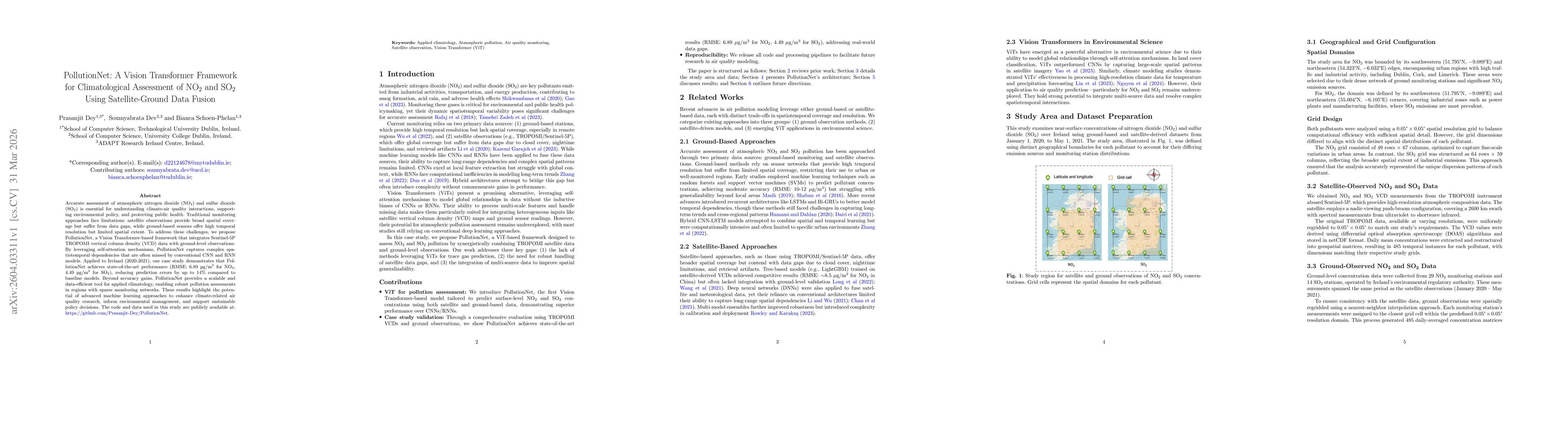
Accurate assessment of atmospheric nitrogen dioxide (NO$_2$) and sulfur dioxide (SO$_2$) is essential for understanding climate-air quality interactions, supporting environmental policy, and protectin...
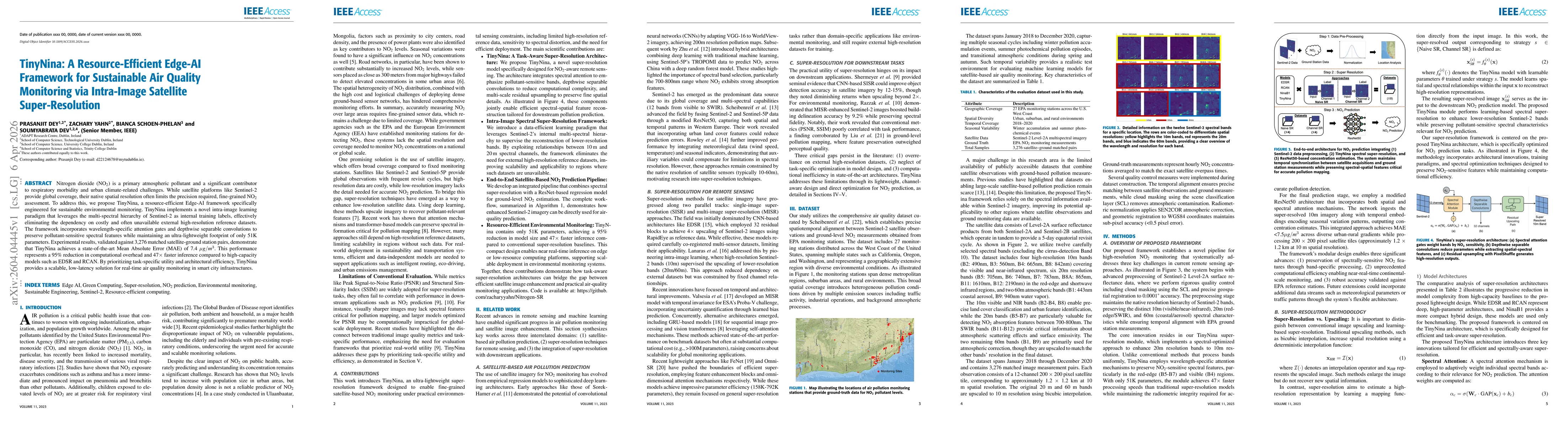
Nitrogen dioxide (NO$_2$) is a primary atmospheric pollutant and a significant contributor to respiratory morbidity and urban climate-related challenges. While satellite platforms like Sentinel-2 prov...