Steffen Knoblauch

10 papers on arXiv

Academic Profile

Name: Stefen Knoblauch
Total Papers: 4

Statistics

arXiv Papers 10
Total Publications 4

Papers on arXiv

Thumbnail for GeoDEN: A Visual Exploration Tool for Analysing the Geographic Spread of
  Dengue Serotypes

GeoDEN: A Visual Exploration Tool for Analysing the Geographic Spread of Dengue Serotypes

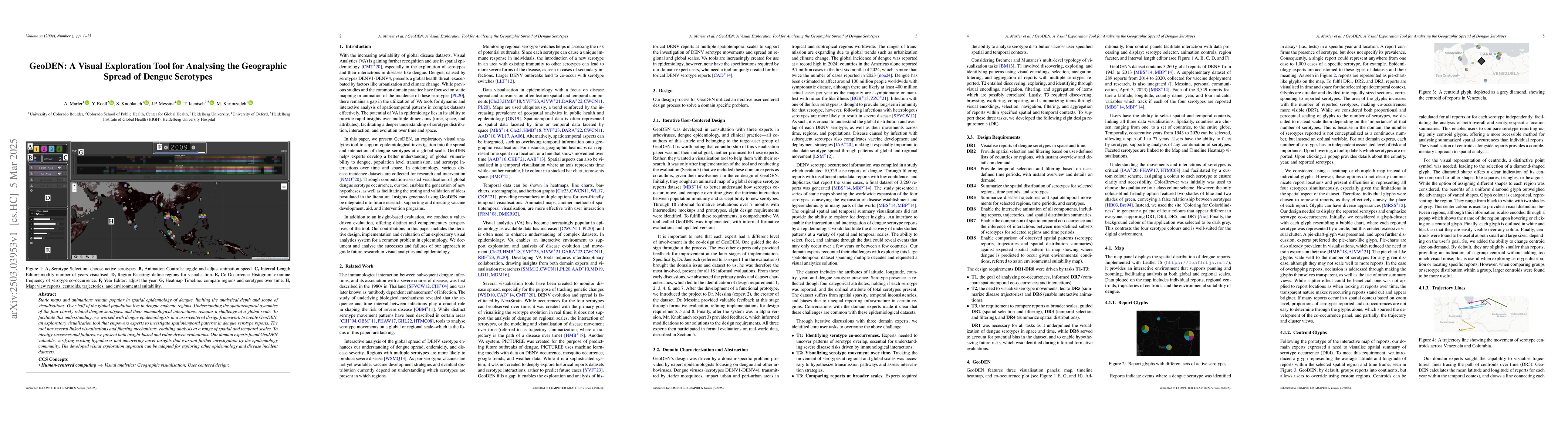
Static maps and animations remain popular in spatial epidemiology of dengue, limiting the analytical depth and scope of visualisations. Over half of the global population live in dengue endemic region...

Thumbnail for SHRUG-FM: Reliability-Aware Foundation Models for Earth Observation

SHRUG-FM: Reliability-Aware Foundation Models for Earth Observation

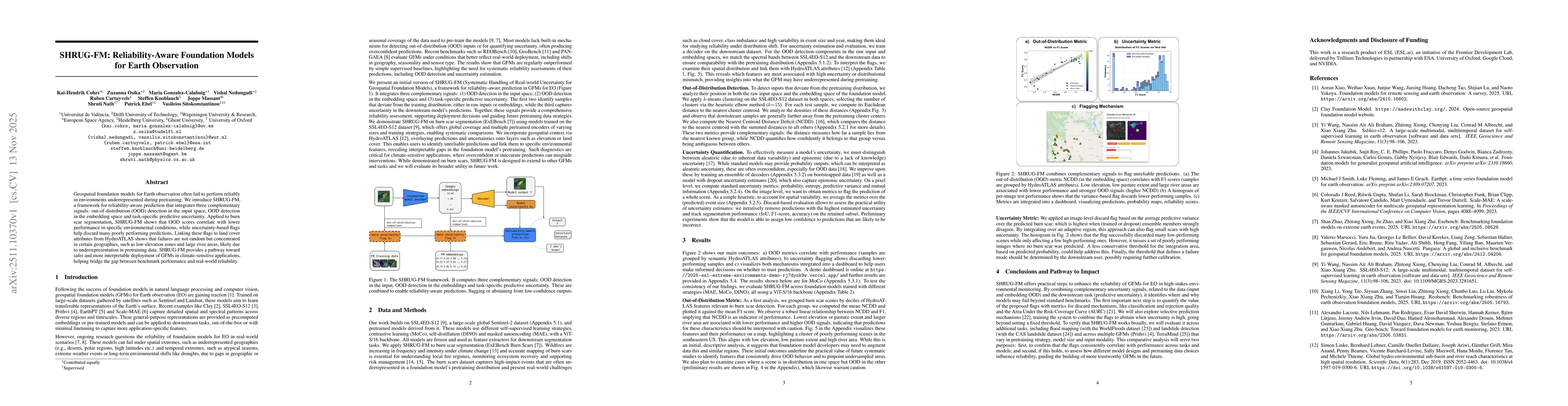
Geospatial foundation models for Earth observation often fail to perform reliably in environments underrepresented during pretraining. We introduce SHRUG-FM, a framework for reliability-aware predicti...

Thumbnail for Towards Generative Location Awareness for Disaster Response: A Probabilistic Cross-view Geolocalization Approach

Towards Generative Location Awareness for Disaster Response: A Probabilistic Cross-view Geolocalization Approach

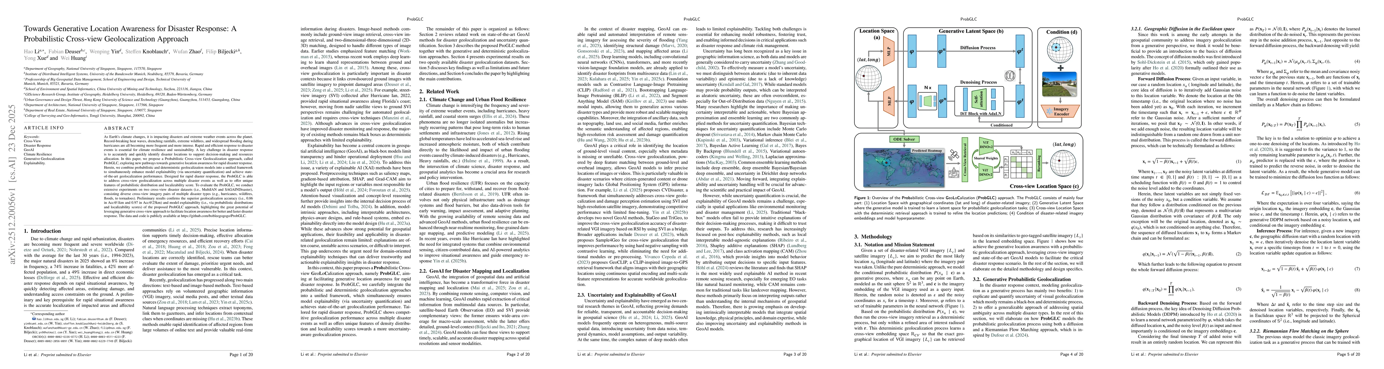
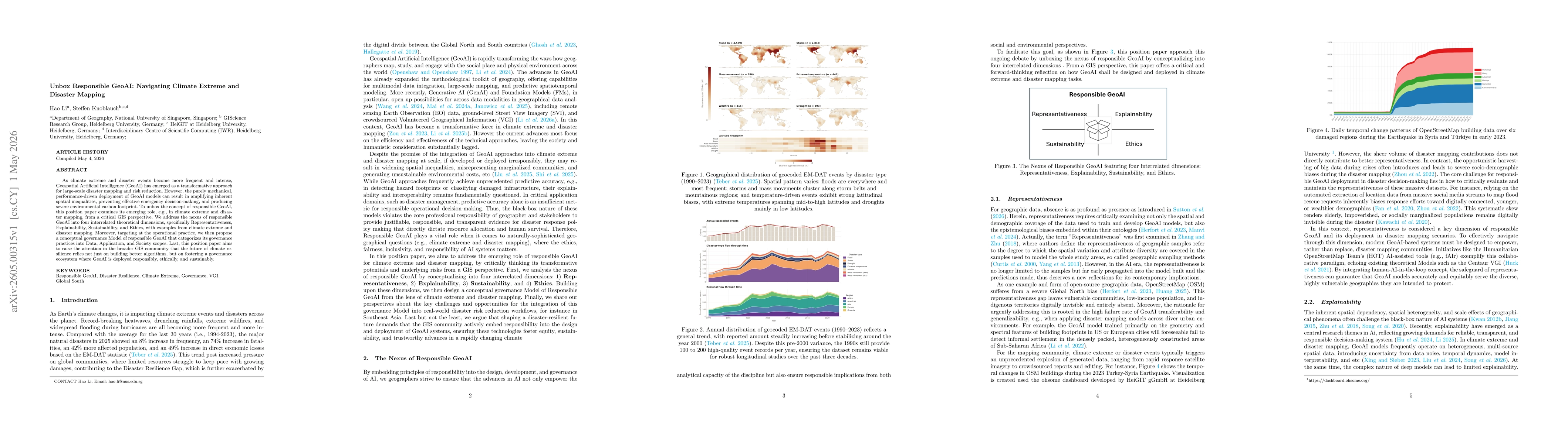
As Earth's climate changes, it is impacting disasters and extreme weather events across the planet. Record-breaking heat waves, drenching rainfalls, extreme wildfires, and widespread flooding during h...

Thumbnail for Assessing Building Heat Resilience Using UAV and Street-View Imagery with Coupled Global Context Vision Transformer

Assessing Building Heat Resilience Using UAV and Street-View Imagery with Coupled Global Context Vision Transformer

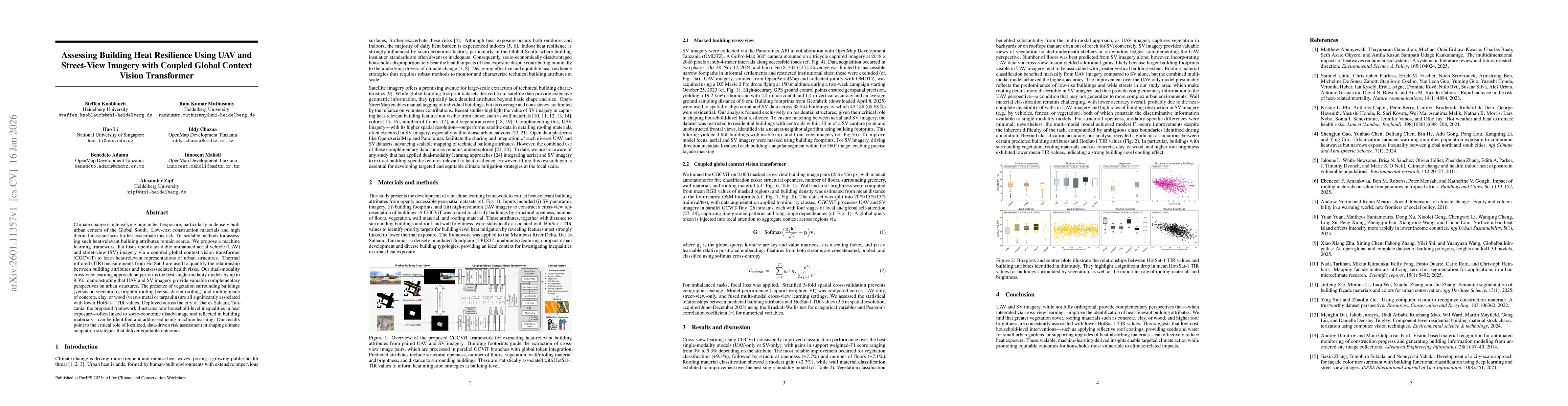
Climate change is intensifying human heat exposure, particularly in densely built urban centers of the Global South. Low-cost construction materials and high thermal-mass surfaces further exacerbate t...

Thumbnail for Automated Road Crack Localization to Guide Highway Maintenance

Automated Road Crack Localization to Guide Highway Maintenance

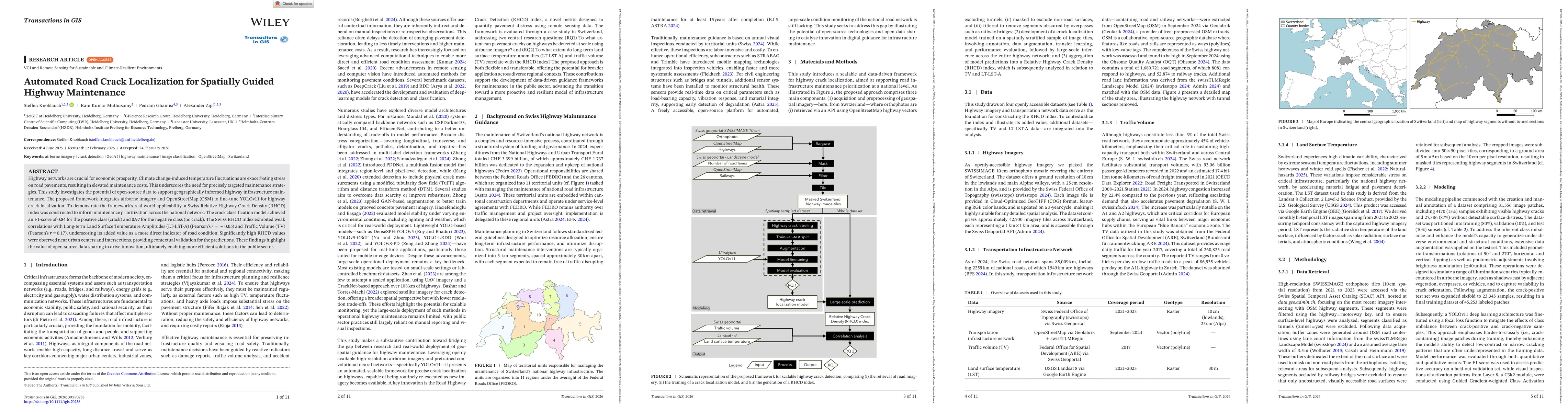
Highway networks are crucial for economic prosperity. Climate change-induced temperature fluctuations are exacerbating stress on road pavements, resulting in elevated maintenance costs. This underscor...

Thumbnail for AI-based Waste Mapping for Addressing Climate-Exacerbated Flood Risk

AI-based Waste Mapping for Addressing Climate-Exacerbated Flood Risk

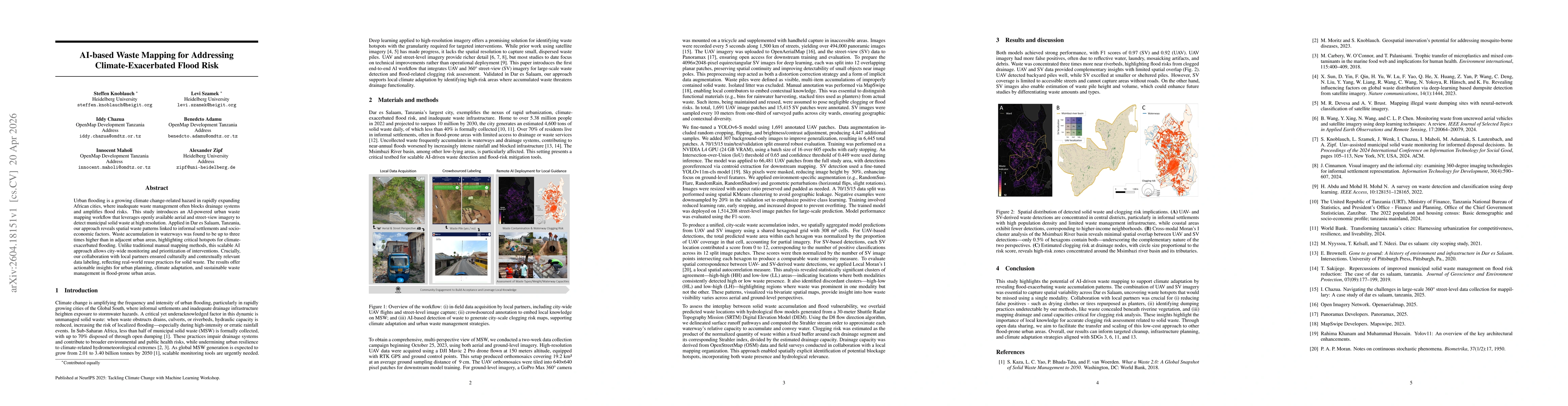
Urban flooding is a growing climate change-related hazard in rapidly expanding African cities, where inadequate waste management often blocks drainage systems and amplifies flood risks. This study int...

Thumbnail for Unbox Responsible GeoAI: Navigating Climate Extreme and Disaster Mapping

Unbox Responsible GeoAI: Navigating Climate Extreme and Disaster Mapping

As climate extreme and disaster events become more frequent and intense, Geospatial Artificial Intelligence (GeoAI) has emerged as a transformative approach for large-scale disaster mapping and risk r...

Thumbnail for Open-access model for detecting openly dumped dispersed municipal solid waste from crowdsourced UAV imagery in Sub-Saharan Africa

Open-access model for detecting openly dumped dispersed municipal solid waste from crowdsourced UAV imagery in Sub-Saharan Africa

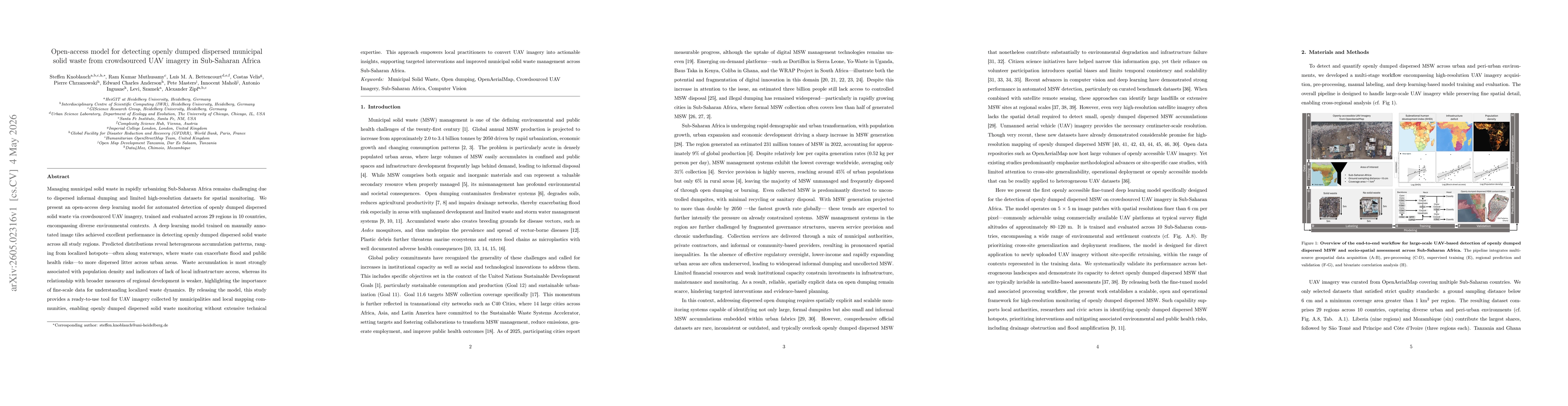
Managing municipal solid waste in rapidly urbanizing Sub-Saharan Africa remains challenging due to dispersed informal dumping and limited high-resolution datasets for spatial monitoring. We present an...

Thumbnail for The NetMob26 Dataset: A High-Resolution Multi-Source View of Public Bus Mobility in Niterói

The NetMob26 Dataset: A High-Resolution Multi-Source View of Public Bus Mobility in Niterói

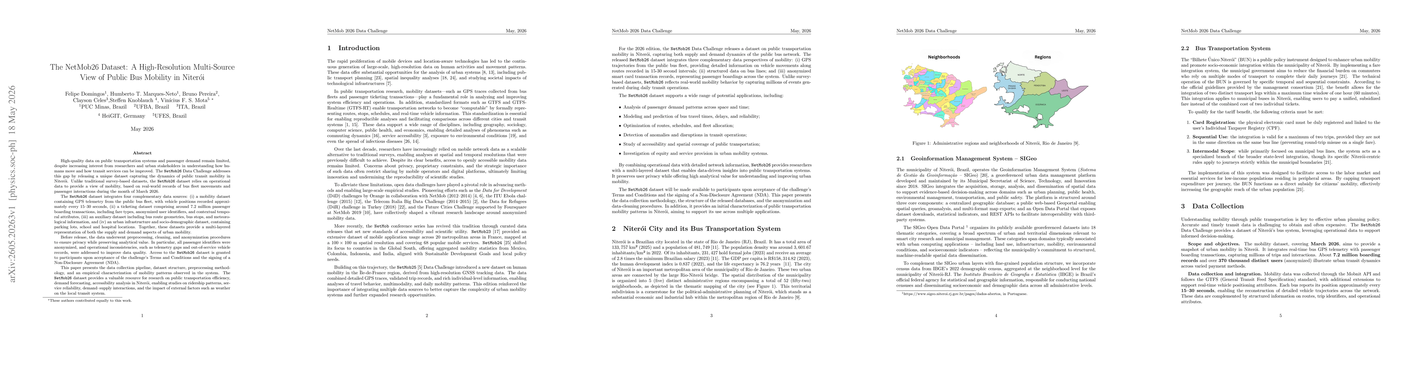
The NetMob Data Challenge releases a comprehensive public transportation dataset from Niterói, addressing the lack of high-quality mobility and passenger demand data. Based on operational records from...

Thumbnail for Spatial Representation Learning Beyond Pixels: Unifying Raster Data and Vector Semantics for Human-Centric Geospatial Foundation Models

Spatial Representation Learning Beyond Pixels: Unifying Raster Data and Vector Semantics for Human-Centric Geospatial Foundation Models

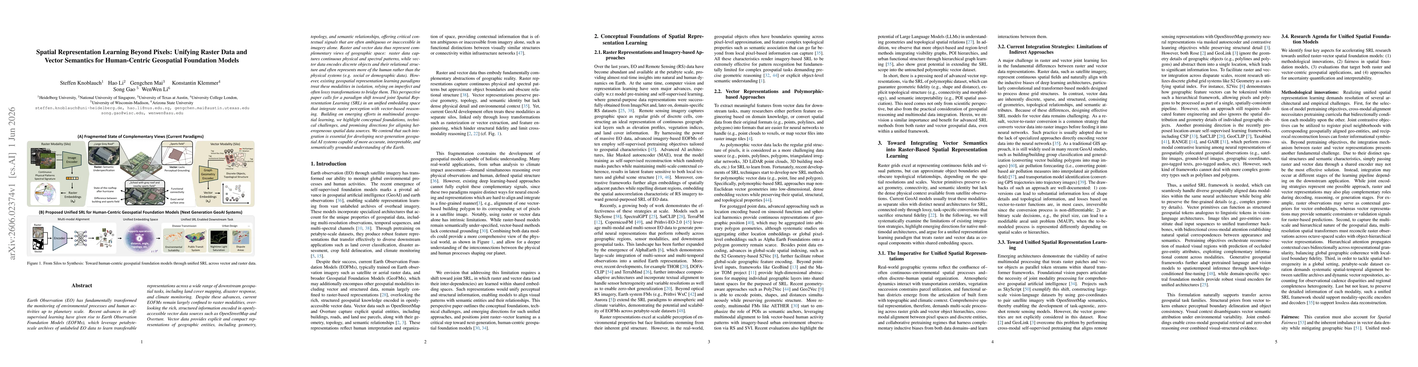
Earth Observation (EO) has fundamentally transformed the monitoring of environmental processes and human activities up to planetary scale. Recent advances in self-supervised learning have given rise t...

This website uses cookies to ensure you get the best experience. Learn more