ArxivLens
Y
Researcher

Yinrui Ren

5 papers on arXiv

5 arXiv Papers
Metrics

Statistics

5 arXiv Papers
Publications

Papers on arXiv

Thumbnail for Beyond a Single Light: A Large-Scale Aerial Dataset for Urban Scene Reconstruction Under Varying Illumination
arXiv
Beyond a Single Light: A Large-Scale Aerial Dataset for Urban Scene Reconstruction Under Varying Illumination

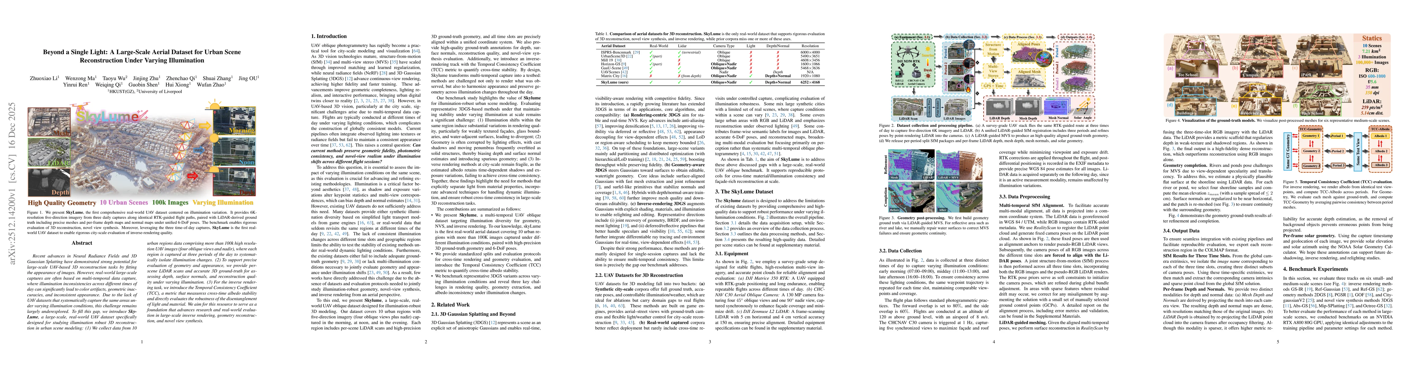
Recent advances in Neural Radiance Fields and 3D Gaussian Splatting have demonstrated strong potential for large-scale UAV-based 3D reconstruction tasks by fitting the appearance of images. However, r...

Thumbnail for EventVGGT: Exploring Cross-Modal Distillation for Consistent Event-based Depth Estimation
arXiv
EventVGGT: Exploring Cross-Modal Distillation for Consistent Event-based Depth Estimation

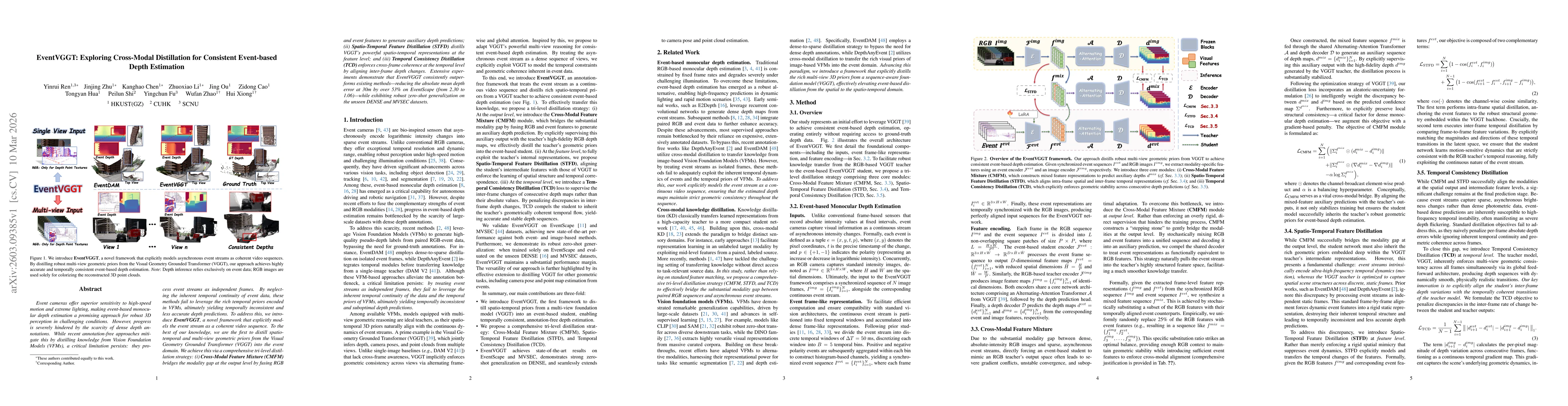
Event cameras offer superior sensitivity to high-speed motion and extreme lighting, making event-based monocular depth estimation a promising approach for robust 3D perception in challenging condition...

Thumbnail for Holo360D: A Large-Scale Real-World Dataset with Continuous Trajectories for Advancing Panoramic 3D Reconstruction and Beyond
arXiv
Holo360D: A Large-Scale Real-World Dataset with Continuous Trajectories for Advancing Panoramic 3D Reconstruction and Beyond

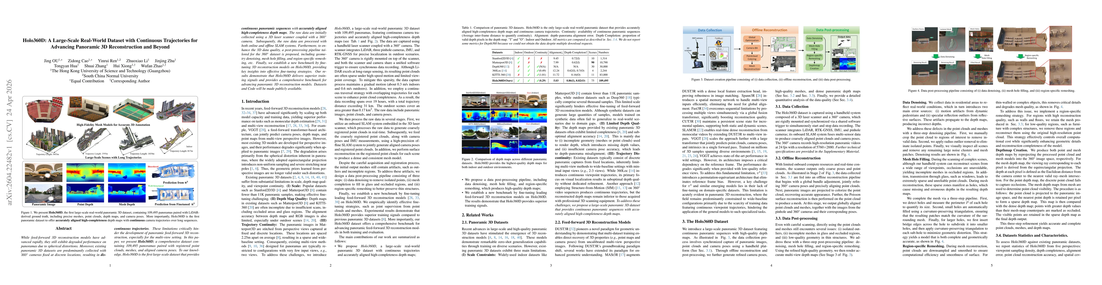
While feed-forward 3D reconstruction models have advanced rapidly, they still exhibit degraded performance on panoramas due to spherical distortions. Moreover, existing panoramic 3D datasets are predo...

Thumbnail for Feed-Forward Gaussian Splatting from Sparse Aerial Views
arXiv
Feed-Forward Gaussian Splatting from Sparse Aerial Views

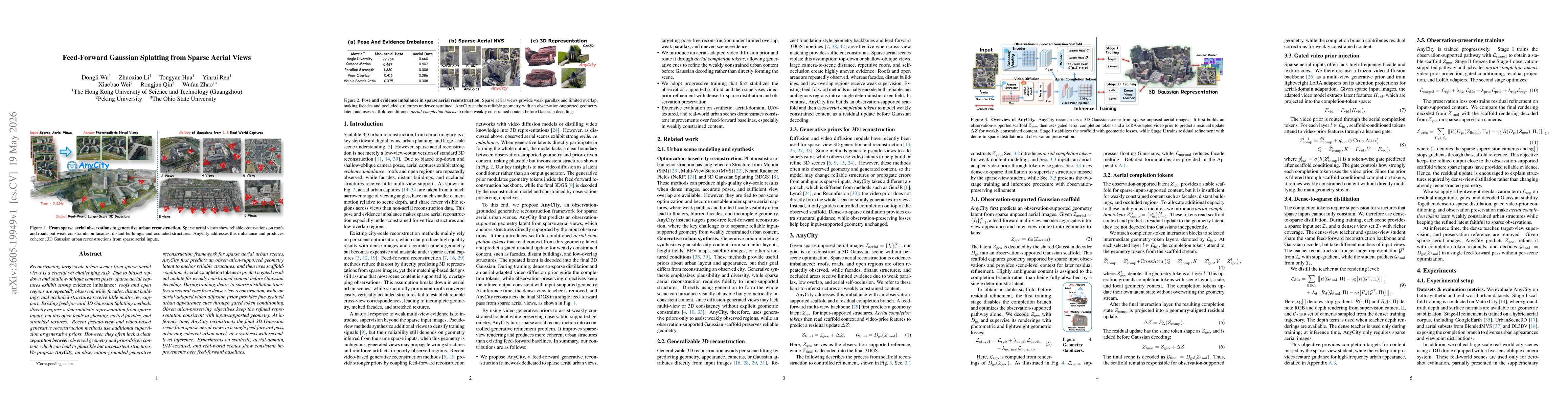
Reconstructing large-scale urban scenes from sparse aerial views is a crucial yet challenging task. Due to biased top-down and shallow-oblique camera poses, sparse aerial captures exhibit strong evide...

Thumbnail for Sat2City v2: Native 3D City Asset Generation from a Single Satellite Image
arXiv
Sat2City v2: Native 3D City Asset Generation from a Single Satellite Image

Generating explicit 3D city assets from a single satellite image is important for digital twins, urban simulation, and geospatial intelligence. Unlike satellite-to-street-view synthesis, the task requ...

This website uses cookies to ensure you get the best experience. Learn more