ArxivLens
Y
Researcher

Yury Brodskiy

10 papers on arXiv

10 arXiv Papers
8 Total Publications
Profile

Academic Profile

Name Y. Brodskiy
Total Papers 8
Scholar Profile View on Semantic Scholar
Metrics

Statistics

10 arXiv Papers
8 Total Publications
Publications

Papers on arXiv

Thumbnail for Uncertainty Driven Active Learning for Image Segmentation in Underwater
  Inspection
arXiv
Uncertainty Driven Active Learning for Image Segmentation in Underwater Inspection

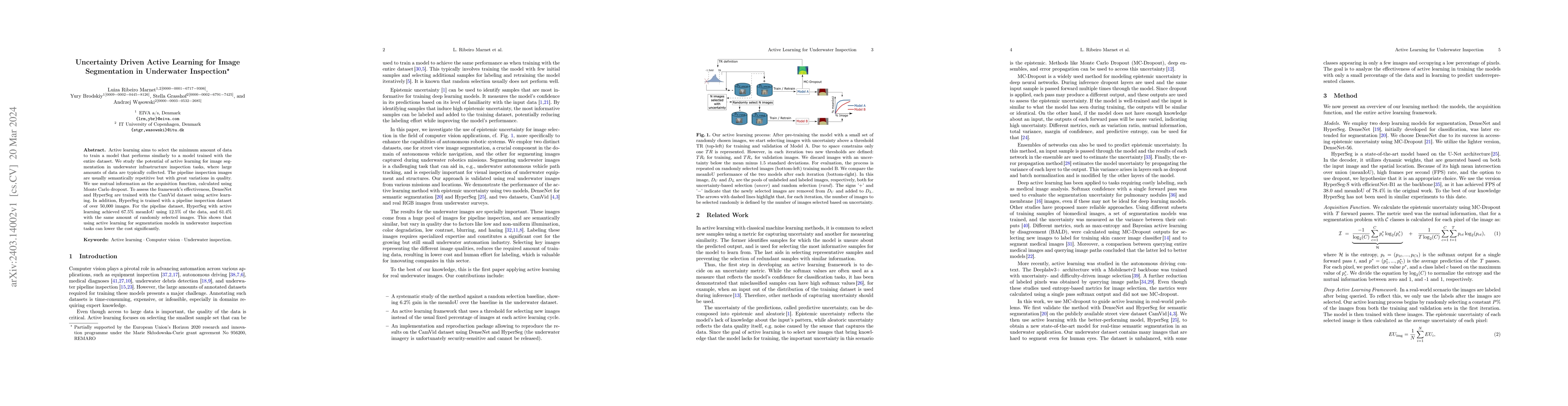
Active learning aims to select the minimum amount of data to train a model that performs similarly to a model trained with the entire dataset. We study the potential of active learning for image seg...

Thumbnail for Mission Planning and Safety Assessment for Pipeline Inspection Using
  Autonomous Underwater Vehicles: A Framework based on Behavior Trees
arXiv
Mission Planning and Safety Assessment for Pipeline Inspection Using Autonomous Underwater Vehicles: A Framework based on Behavior Trees

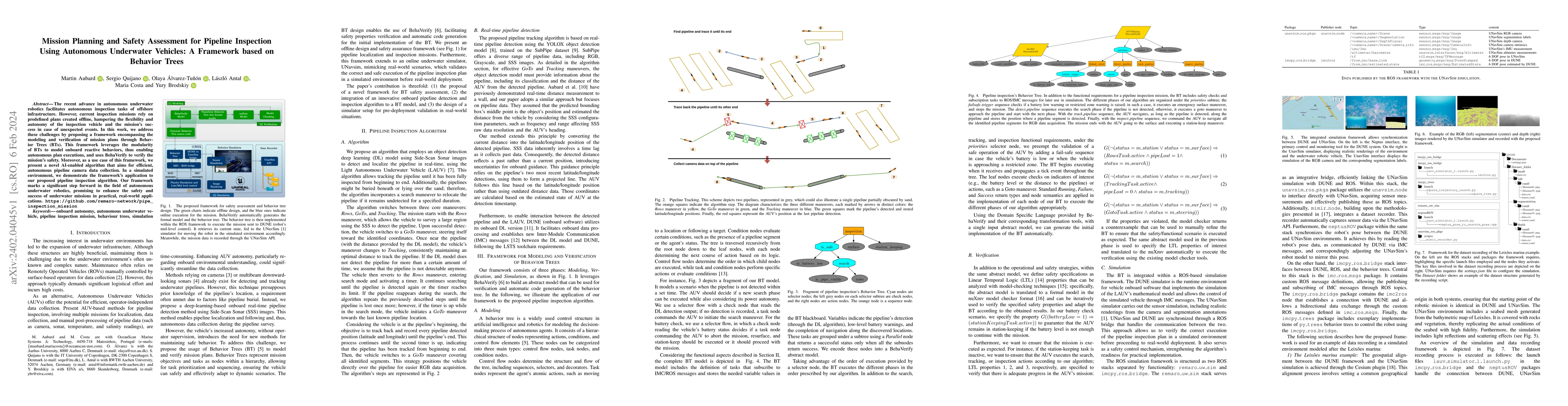
The recent advance in autonomous underwater robotics facilitates autonomous inspection tasks of offshore infrastructure. However, current inspection missions rely on predefined plans created offline...

Thumbnail for SubPipe: A Submarine Pipeline Inspection Dataset for Segmentation and
  Visual-inertial Localization
arXiv
SubPipe: A Submarine Pipeline Inspection Dataset for Segmentation and Visual-inertial Localization

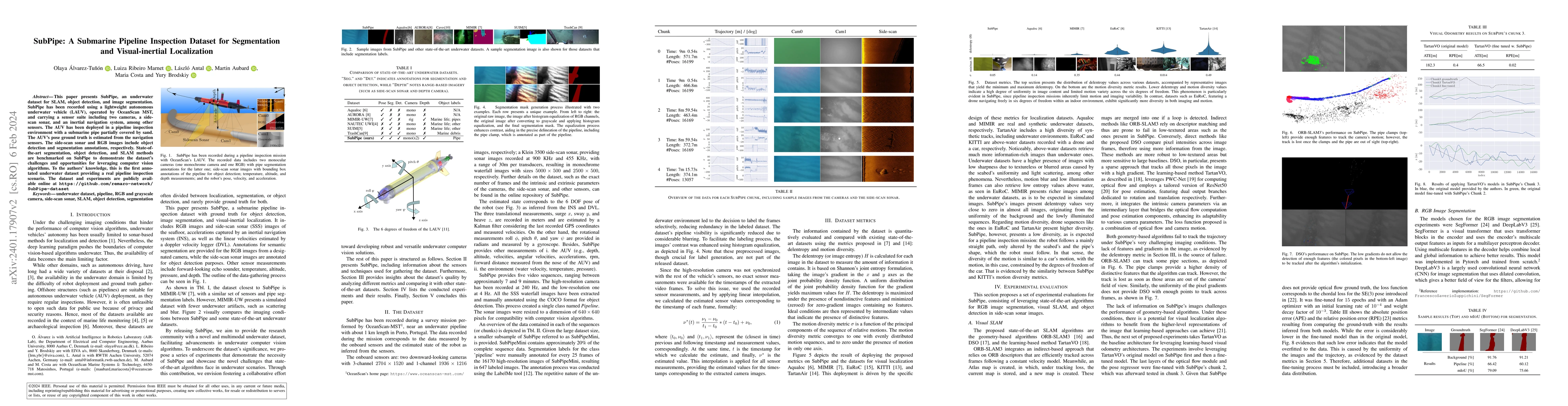
This paper presents SubPipe, an underwater dataset for SLAM, object detection, and image segmentation. SubPipe has been recorded using a \gls{LAUV}, operated by OceanScan MST, and carrying a sensor ...

Thumbnail for Loss it right: Euclidean and Riemannian Metrics in Learning-based Visual
  Odometry
arXiv
Loss it right: Euclidean and Riemannian Metrics in Learning-based Visual Odometry

This paper overviews different pose representations and metric functions in visual odometry (VO) networks. The performance of VO networks heavily relies on how their architecture encodes the informa...

Thumbnail for UNav-Sim: A Visually Realistic Underwater Robotics Simulator and
  Synthetic Data-generation Framework
arXiv
UNav-Sim: A Visually Realistic Underwater Robotics Simulator and Synthetic Data-generation Framework

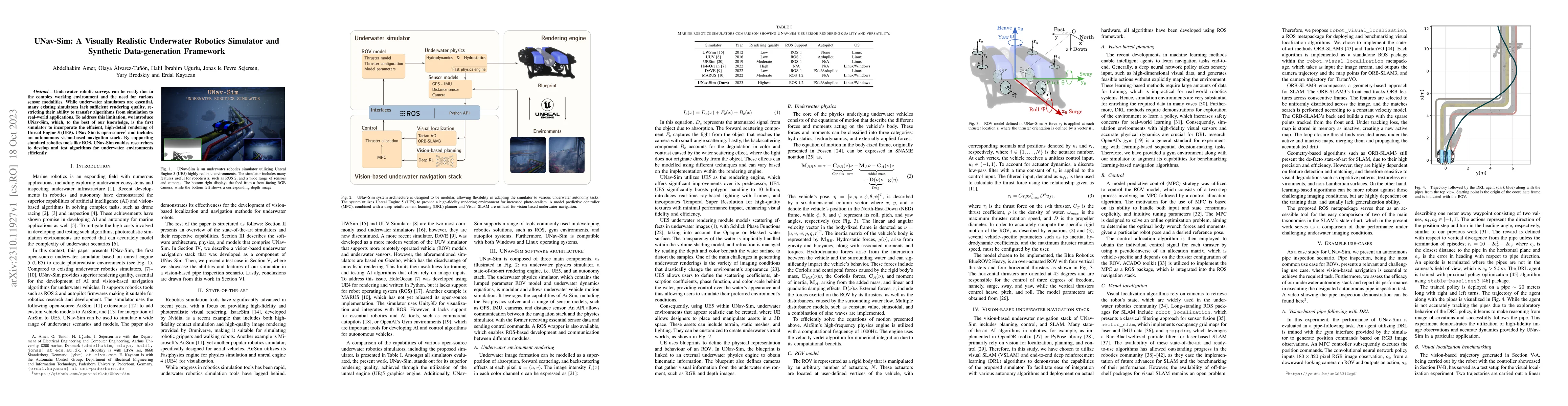
Underwater robotic surveys can be costly due to the complex working environment and the need for various sensor modalities. While underwater simulators are essential, many existing simulators lack s...

Thumbnail for UnsuperPoint: End-to-end Unsupervised Interest Point Detector and
  Descriptor
arXiv
UnsuperPoint: End-to-end Unsupervised Interest Point Detector and Descriptor

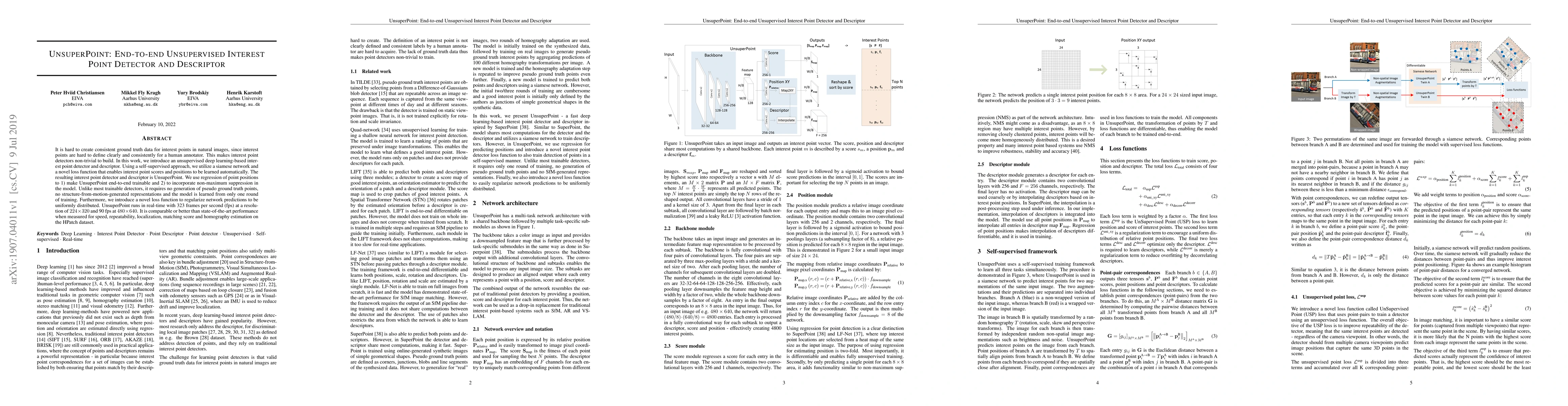
It is hard to create consistent ground truth data for interest points in natural images, since interest points are hard to define clearly and consistently for a human annotator. This makes interest ...

Thumbnail for Monocular visual simultaneous localization and mapping: (r)evolution
  from geometry to deep learning-based pipelines
arXiv
Monocular visual simultaneous localization and mapping: (r)evolution from geometry to deep learning-based pipelines

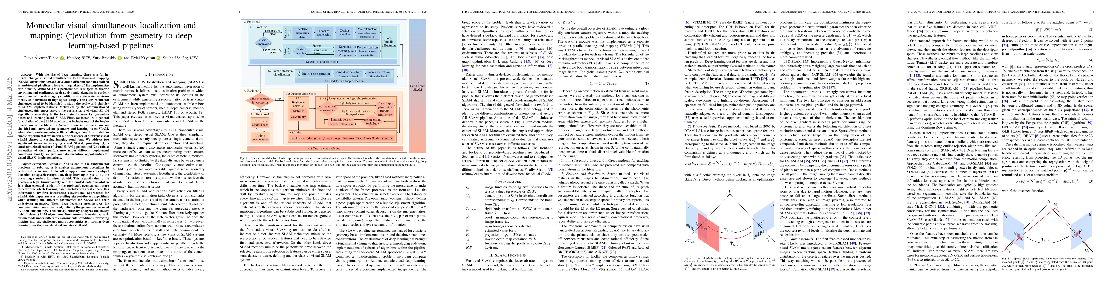
With the rise of deep learning, there is a fundamental change in visual SLAM algorithms toward developing different modules trained as end-to-end pipelines. However, regardless of the implementation d...

Thumbnail for Modelling of Underwater Vehicles using Physics-Informed Neural Networks
  with Control
arXiv
Modelling of Underwater Vehicles using Physics-Informed Neural Networks with Control

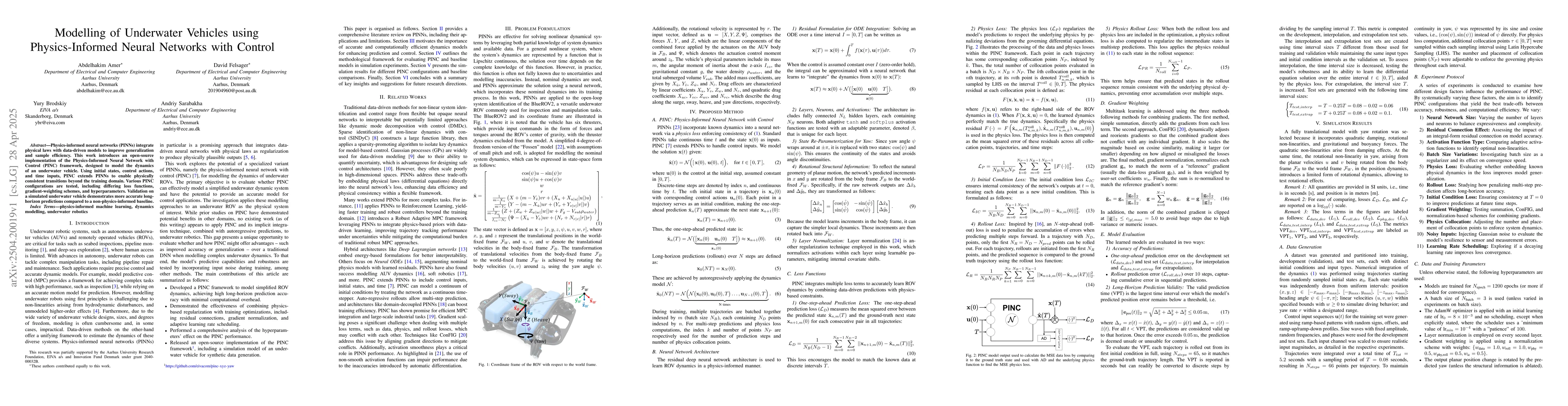
Physics-informed neural networks (PINNs) integrate physical laws with data-driven models to improve generalization and sample efficiency. This work introduces an open-source implementation of the Phys...

Thumbnail for REACT: Real-time Entanglement-Aware Coverage Path Planning for Tethered
  Underwater Vehicles
arXiv
REACT: Real-time Entanglement-Aware Coverage Path Planning for Tethered Underwater Vehicles

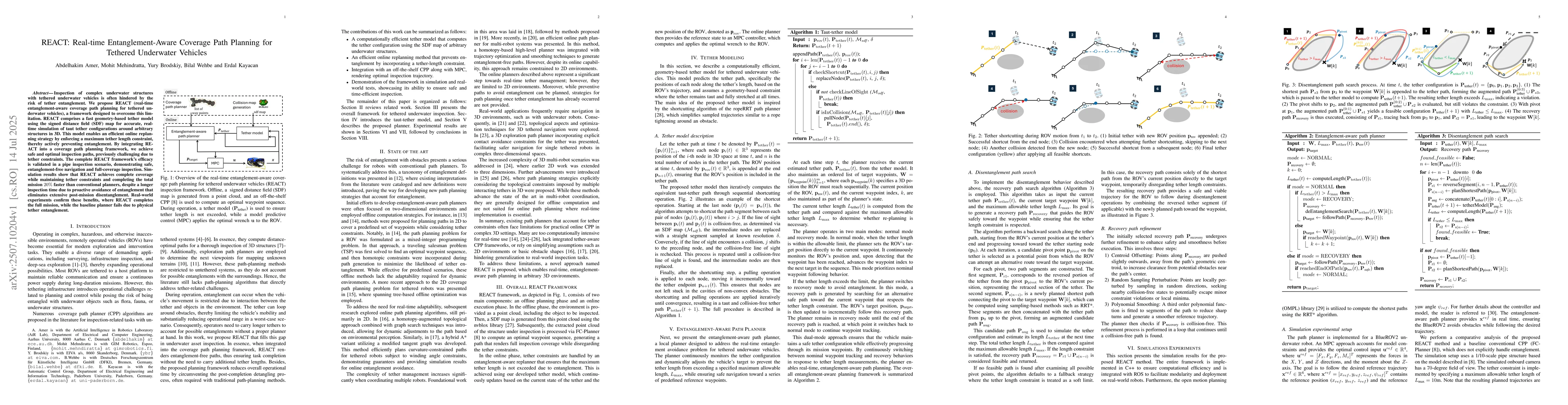
Inspection of complex underwater structures with tethered underwater vehicles is often hindered by the risk of tether entanglement. We propose REACT (real-time entanglement-aware coverage path plannin...

Thumbnail for SeaVis: Modeling and Control of a Remotely Operated Towed Vehicle for Seabed Visualization and Mapping
arXiv
SeaVis: Modeling and Control of a Remotely Operated Towed Vehicle for Seabed Visualization and Mapping

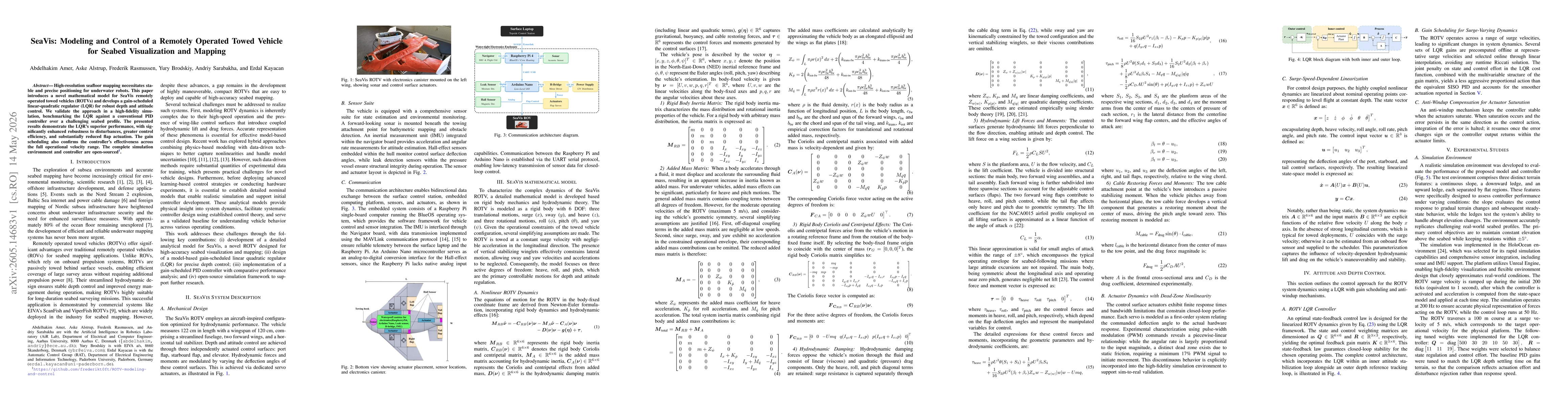
High-resolution seafloor mapping necessitates stable and precise positioning for underwater robots. This paper introduces a novel mathematical model for SeaVis remotely operated towed vehicles (ROTVs)...

This website uses cookies to ensure you get the best experience. Learn more