2-speed network ensemble for efficient classification of incremental land-use/land-cover satellite image chips
Publication
Metrics
AI Quick Summary
This research proposes an efficient ensemble model for classifying satellite image chips, combining a high-accuracy but slow-to-train vision transformer with a fast but less accurate convolutional neural network. The ensemble aims to address the challenges of scaling and retraining deep learning models for large satellite datasets, achieving a best accuracy of 65% on the So2Sat LCZ42 dataset. The study suggests a scalable, cost-effective solution for processing vast volumes of satellite imagery.
Paper Preview
Abstract
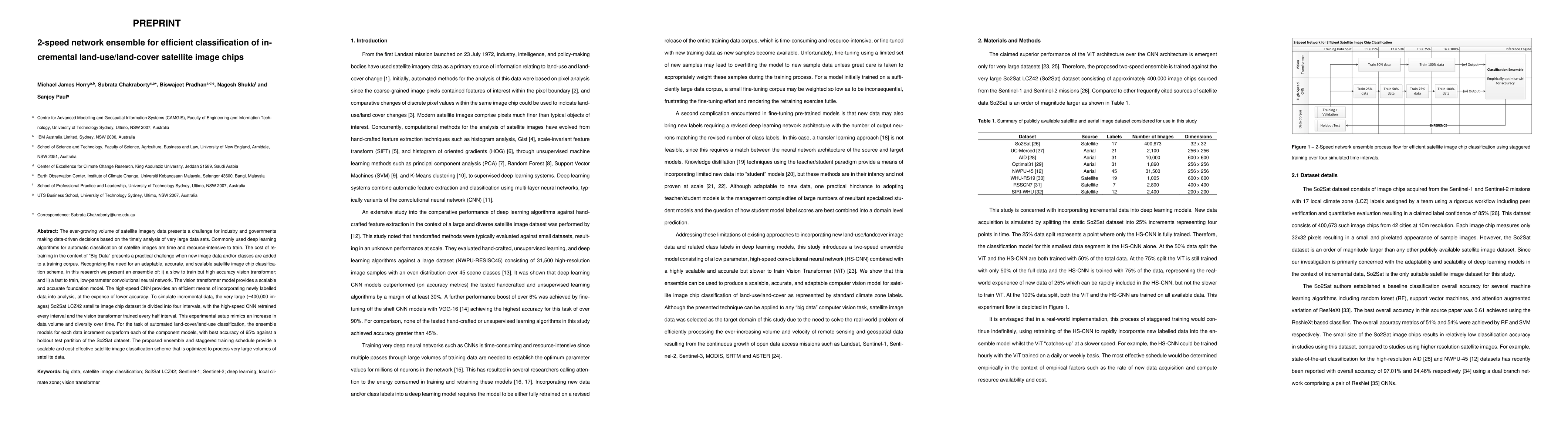
The ever-growing volume of satellite imagery data presents a challenge for industry and governments making data-driven decisions based on the timely analysis of very large data sets. Commonly used deep learning algorithms for automatic classification of satellite images are time and resource-intensive to train. The cost of retraining in the context of Big Data presents a practical challenge when new image data and/or classes are added to a training corpus. Recognizing the need for an adaptable, accurate, and scalable satellite image chip classification scheme, in this research we present an ensemble of: i) a slow to train but high accuracy vision transformer; and ii) a fast to train, low-parameter convolutional neural network. The vision transformer model provides a scalable and accurate foundation model. The high-speed CNN provides an efficient means of incorporating newly labelled data into analysis, at the expense of lower accuracy. To simulate incremental data, the very large (~400,000 images) So2Sat LCZ42 satellite image chip dataset is divided into four intervals, with the high-speed CNN retrained every interval and the vision transformer trained every half interval. This experimental setup mimics an increase in data volume and diversity over time. For the task of automated land-cover/land-use classification, the ensemble models for each data increment outperform each of the component models, with best accuracy of 65% against a holdout test partition of the So2Sat dataset. The proposed ensemble and staggered training schedule provide a scalable and cost-effective satellite image classification scheme that is optimized to process very large volumes of satellite data.
AI Key Findings
Get AI-generated insights about this paper's methodology, results, significance, and more — seven facets brought into focus.
Impact
Paper Details
Authors
PDF Preview
Key Terms
Citation Network
Current paper (gray), citations (green), references (blue)
Display is limited for performance on very large graphs.
Discussion 0