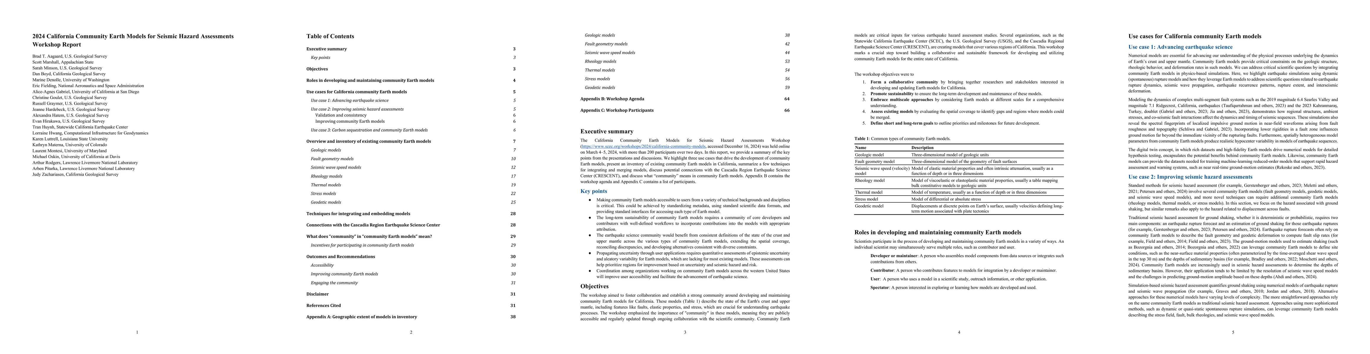
Quick Summary:

This workshop report summarizes key discussions from the California Community Earth Models for Seismic Hazard Assessments held online in March 2024, highlighting three use cases, an inventory of existing models, techniques for model integration, potential connections with CRESCENT, and the concept of "community" in these models. The report includes the workshop agenda and a list of participants.

Summary

The California Community Earth Models for Seismic Hazard Assessments Workshop (https://www.scec.org/workshops/2024/california-community-models, accessed December 16, 2024) was held online on March 4-5, 2024, with more than 200 participants over two days. In this report, we provide a summary of the key points from the presentations and discussions. We highlight three use cases that drive the development of community Earth models, present an inventory of existing community Earth models in California, summarize a few techniques for integrating and merging models, discuss potential connections with the Cascadia Region Earthquake Science Center (CRESCENT), and discuss what "community" means in community Earth models. Appendix B contains the workshop agenda and Appendix C contains a list of participants.

AI Key Findings

Generated Jun 10, 2025

Methodology

The workshop report summarizes the 2024 California Community Earth Models for Seismic Hazard Assessments, focusing on presentations, discussions, and use cases. It highlights existing models, integration techniques, potential CRESCENT connections, and the concept of 'community' in Earth model development.

Key Results

  • Three use cases drive the development of community Earth models: seismic hazard assessment, geological understanding, and supporting earthquake-related industries.
  • An inventory of existing geodetic models in California is provided, including NSHM Velocity Field, USGS GNSS Velocities, ARIA and OPERA products, UAVSAR geodetic displacement dataset, Sentinel-1 velocity and time series product, InSAR and GNSS combined velocity 3D velocity, SCEC CGM v2.0, and Eastern California Slip Rates.
  • Techniques for integrating and merging models are discussed, including aligning InSAR with GNSS, blending and tapering techniques, and building models with consistent techniques across domains.

Significance

This research is significant as it fosters collaboration and standardization in developing community Earth models, which are crucial for seismic hazard assessments, geological understanding, and supporting earthquake-related industries. It also presents opportunities for collaboration with CRESCENT, enhancing the west coast's seismic model coverage.

Technical Contribution

The workshop report presents a comprehensive overview of existing geodetic models in California, integration techniques, and the concept of 'community' in Earth model development, fostering collaboration and standardization.

Novelty

The report emphasizes the importance of community engagement and collaboration in developing Earth models, which differentiates it from individual research group-produced models by incorporating diverse datasets, community-defined goals, and accessible models for various applications.

Limitations

  • The report does not provide detailed technical specifications for each model.
  • It lacks comprehensive analysis of the accuracy and reliability of the models.

Future Work

  • Prioritize filling gaps in geographic coverage of models.
  • Reconcile discrepancies among overlapping models and document alternative interpretations.

Paper Details

PDF Preview

Download PDF

Key Terms

No key terms available for this paper.

Citation Network

Current paper (gray), citations (green), references (blue)

Current Paper
Citations
References
Click to view

Similar Papers

Found 4 papers

No citations found for this paper.

Comments (0)

This website uses cookies to ensure you get the best experience. Learn more