3DGS_LSR:Large_Scale Relocation for Autonomous Driving Based on 3D Gaussian Splatting
Publication
Metrics
Paper Preview
Abstract
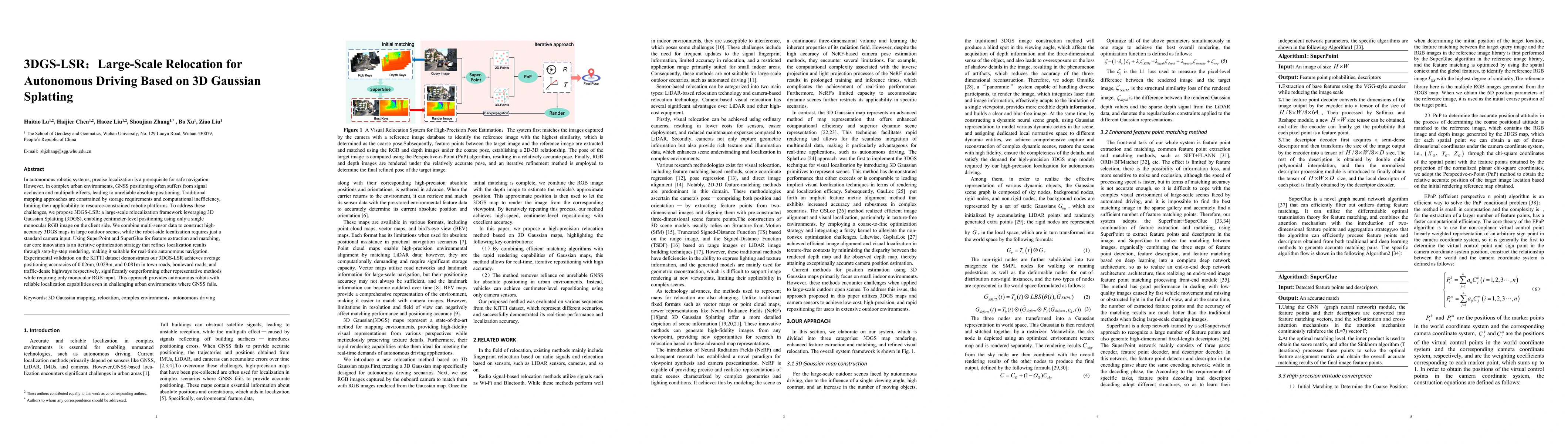
In autonomous robotic systems, precise localization is a prerequisite for safe navigation. However, in complex urban environments, GNSS positioning often suffers from signal occlusion and multipath effects, leading to unreliable absolute positioning. Traditional mapping approaches are constrained by storage requirements and computational inefficiency, limiting their applicability to resource-constrained robotic platforms. To address these challenges, we propose 3DGS-LSR: a large-scale relocalization framework leveraging 3D Gaussian Splatting (3DGS), enabling centimeter-level positioning using only a single monocular RGB image on the client side. We combine multi-sensor data to construct high-accuracy 3DGS maps in large outdoor scenes, while the robot-side localization requires just a standard camera input. Using SuperPoint and SuperGlue for feature extraction and matching, our core innovation is an iterative optimization strategy that refines localization results through step-by-step rendering, making it suitable for real-time autonomous navigation. Experimental validation on the KITTI dataset demonstrates our 3DGS-LSR achieves average positioning accuracies of 0.026m, 0.029m, and 0.081m in town roads, boulevard roads, and traffic-dense highways respectively, significantly outperforming other representative methods while requiring only monocular RGB input. This approach provides autonomous robots with reliable localization capabilities even in challenging urban environments where GNSS fails.
AI Key Findings
Get AI-generated insights about this paper's methodology, results, significance, and more — seven facets brought into focus.
Impact
Paper Details
Authors
PDF Preview
Citation Network
Current paper (gray), citations (green), references (blue)
Display is limited for performance on very large graphs.
Discussion 0