Summary

For utilizing autonomous vehicle in urban areas a reliable localization is needed. Especially when HD maps are used, a precise and repeatable method has to be chosen. Therefore accurate map generation but also re-localization against these maps is necessary. Due to best 3D reconstruction of the surrounding, LiDAR has become a reliable modality for localization. The latest LiDAR odometry estimation are based on iterative closest point (ICP) approaches, namely KISS-ICP and SAGE-ICP. We extend the capabilities of KISS-ICP by incorporating semantic information into the point alignment process using a generalizable approach with minimal parameter tuning. This enhancement allows us to surpass KISS-ICP in terms of absolute trajectory error (ATE), the primary metric for map accuracy. Additionally, we improve the Cartographer mapping framework to handle semantic information. Cartographer facilitates loop closure detection over larger areas, mitigating odometry drift and further enhancing ATE accuracy. By integrating semantic information into the mapping 
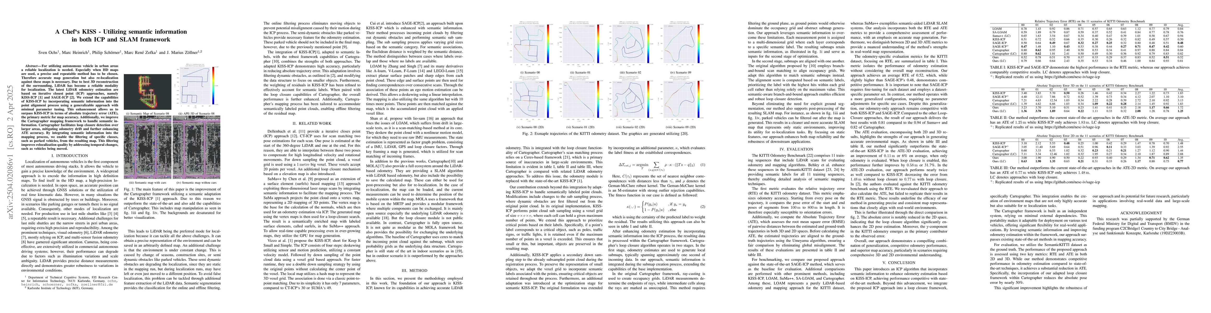
process, we enable the filtering of specific classes, such as parked vehicles, from the resulting map. This filtering improves relocalization quality by addressing temporal changes, such as vehicles being moved.

AI Key Findings

Generated Jun 10, 2025

Methodology

The research methodology involves extending KISS-ICP by incorporating semantic information into the point alignment process, and improving the Cartographer mapping framework to handle semantic information, facilitating loop closure detection and map filtering.

Key Results

  • The proposed approach surpasses KISS-ICP in terms of Absolute Trajectory Error (ATE), the primary metric for map accuracy.
  • Integration of semantic information into mapping enables filtering of specific classes like parked vehicles, improving relocalization quality by addressing temporal changes.

Significance

This research is significant as it enhances the accuracy of LiDAR-based localization and mapping for autonomous vehicles in urban environments, which is crucial for reliable operation in real-world scenarios.

Technical Contribution

The paper presents an extension of KISS-ICP that incorporates semantic information for improved LiDAR odometry and mapping, along with modifications to the Cartographer framework for semantic-aware loop closure and map filtering.

Novelty

The novelty lies in the integration of semantic information into both the ICP process and the Cartographer mapping framework, enhancing odometry accuracy and map reliability for relocalization tasks.

Limitations

  • The paper does not explicitly discuss limitations, but potential limitations could include reliance on high-quality semantic labels and computational overhead due to semantic processing.
  • Performance may vary with the quality and availability of semantic segmentations in diverse environments.

Future Work

  • Exploring more robust methods to handle varying quality of semantic labels.
  • Investigating methods to reduce computational complexity while maintaining accuracy.

Paper Details

PDF Preview

Download PDF

Key Terms

No key terms available for this paper.

Citation Network

Current paper (gray), citations (green), references (blue)

Current Paper
Citations
References
Click to view

Similar Papers

Found 4 papers
Title Authors Year Actions
The ATLAS of Traffic Lights: A Reliable Perception Framework for Autonomous Driving
Rupert Polley, Nikolai Polley, Dominik Heid, Marc Heinrich, Sven Ochs, J. Zollner
2025
View Paper

Comments (0)

This website uses cookies to ensure you get the best experience. Learn more