Publication

Published: Sep 15, 2025
Categories: stat.AP, stat.ML

Metrics

Source: ArXiv

Quick Actions

View PDF

Quick Answers

What methodology did the authors use?

The study compared geostatistical methods (kriging, land use regression) and machine learning models (random forests, support vector machines, neural networks) using PurpleAir sensor data to predict PM2.5 concentrations across California. Cross-validation was used to evaluate model performance with metrics like RMSE, SMAPE, and correlation. More in Methodology →

What are the key results?

Support Vector Regression (SVR) outperformed other non-geostatistical methods across all metrics. — Incorporating spatiotemporal predictors and geostatistical corrections (e.g., NNGP) significantly improved machine learning model performance. More in Key Results →

Why is this work significant?

This research enhances air quality prediction accuracy by integrating low-cost sensor data with advanced statistical and machine learning techniques, aiding in public health and environmental policy decisions. More in Significance →

What are the main limitations?

The study focused on California and may not generalize to other regions with different meteorological patterns. — Computational demands of geostatistical methods like Universal Kriging limited their practical application. More in Limitations →

Paper Preview

Abstract

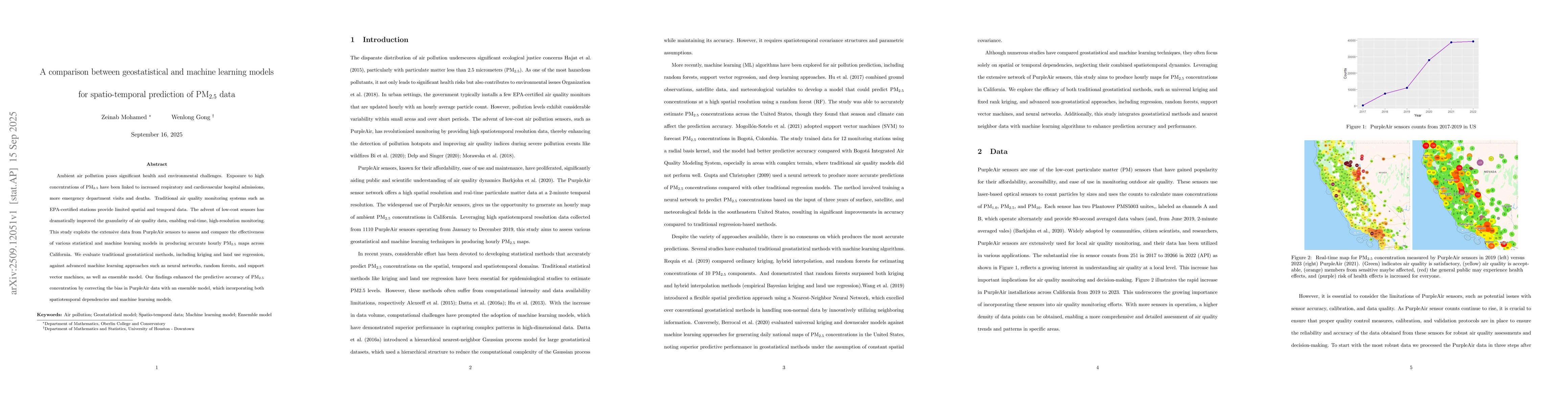
Ambient air pollution poses significant health and environmental challenges. Exposure to high concentrations of PM$_{2.5}$ have been linked to increased respiratory and cardiovascular hospital admissions, more emergency department visits and deaths. Traditional air quality monitoring systems such as EPA-certified stations provide limited spatial and temporal data. The advent of low-cost sensors has dramatically improved the granularity of air quality data, enabling real-time, high-resolution monitoring. This study exploits the extensive data from PurpleAir sensors to assess and compare the effectiveness of various statistical and machine learning models in producing accurate hourly PM$_{2.5}$ maps across California. We evaluate traditional geostatistical methods, including kriging and land use regression, against advanced machine learning approaches such as neural networks, random forests, and support vector machines, as well as ensemble model. Our findings enhanced the predictive accuracy of PM2.5 concentration by correcting the bias in PurpleAir data with an ensemble model, which incorporating both spatiotemporal dependencies and machine learning models.

AI Key Findings

Generated Oct 02, 2025

Methodology — What approach did the authors take?

The study compared geostatistical methods (kriging, land use regression) and machine learning models (random forests, support vector machines, neural networks) using PurpleAir sensor data to predict PM2.5 concentrations across California. Cross-validation was used to evaluate model performance with metrics like RMSE, SMAPE, and correlation.

Key Results — What are the main findings?

  • Support Vector Regression (SVR) outperformed other non-geostatistical methods across all metrics.
  • Incorporating spatiotemporal predictors and geostatistical corrections (e.g., NNGP) significantly improved machine learning model performance.
  • Universal Kriging (UK) showed the best performance among geostatistical methods, followed by NNGP and FRK.

Significance — Why does this research matter?

This research enhances air quality prediction accuracy by integrating low-cost sensor data with advanced statistical and machine learning techniques, aiding in public health and environmental policy decisions.

Technical Contribution — What is the technical contribution?

The study introduced a hybrid approach combining geostatistical corrections with machine learning, demonstrating improved prediction accuracy through spatiotemporal basis functions and ensemble methods.

Novelty — What is new about this work?

The work uniquely combines geostatistical techniques with machine learning models, leveraging both spatial-temporal dependencies and non-linear patterns in PM2.5 data.

Limitations — What are the limitations of this study?

  • The study focused on California and may not generalize to other regions with different meteorological patterns.
  • Computational demands of geostatistical methods like Universal Kriging limited their practical application.

Future Work — What did the authors propose for future work?

  • Integrate real-time traffic and industrial emissions data to improve spatiotemporal dynamics modeling.
  • Develop more efficient algorithms for processing large-scale environmental datasets.

Paper Details

Paper ID: 2509.12051
Categories:
stat.AP stat.ML

How to Cite This Paper

BibTeX
@article{gong2025a,
  title         = {A comparison between geostatistical and machine learning models for
  spatio-temporal prediction of PM2.5 data},
  author        = {Gong, Wenlong and Mohamed, Zeinab},
  year          = {2025},
  eprint        = {2509.12051},
  archivePrefix = {arXiv},
  primaryClass  = {stat.AP},
}
APA 7
Gong, W., & Mohamed, Z. (2025). A comparison between geostatistical and machine learning models for
  spatio-temporal prediction of PM2.5 data. arXiv. https://arxiv.org/abs/2509.12051
MLA 9
Gong, Wenlong, and Zeinab Mohamed. "A comparison between geostatistical and machine learning models for
  spatio-temporal prediction of PM2.5 data." arXiv, 2025, arxiv.org/abs/2509.12051.

Comments (0)

This website uses cookies to ensure you get the best experience. Learn more