Quick Summary:

This paper provides a comprehensive review of remote sensing technologies for wetland classification and mapping, analyzing over 1,200 papers to synthesize current methods, data, and trends. It highlights the scientific importance of wetlands, driving factors of changes, and discusses limitations and future directions in response to global environmental shifts and technological advancements.

Summary

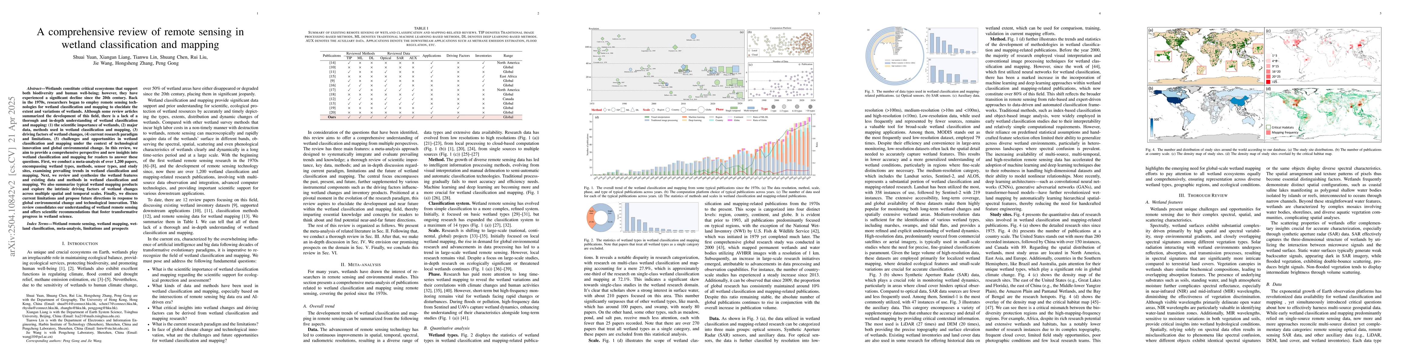
Wetlands constitute critical ecosystems that support both biodiversity and human well-being; however, they have experienced a significant decline since the 20th century. Back in the 1970s, researchers began to employ remote sensing technologies for wetland classification and mapping to elucidate the extent and variations of wetlands. Although some review articles summarized the development of this field, there is a lack of a thorough and in-depth understanding of wetland classification and mapping: (1) the scientific importance of wetlands, (2) major data, methods used in wetland classification and mapping, (3) driving factors of wetland changes, (4) current research paradigm and limitations, (5) challenges and opportunities in wetland classification and mapping under the context of technological innovation and global environmental change. In this review, we aim to provide a comprehensive perspective and new insights into wetland classification and mapping for readers to answer these questions. First, we conduct a meta-analysis of over 1,200 papers, encompassing wetland types, methods, sensor types, and study sites, examining prevailing trends in wetland classification and mapping. Next, we review and synthesize the wetland features and existing data and methods in wetland classification and mapping. We also summarize typical wetland mapping products and explore the intrinsic driving factors of wetland changes across multiple spatial and temporal scales. Finally, we discuss current limitations and propose future directions in response to global environmental change and technological innovation. This review consolidates our understanding of wetland remote sensing and offers scientific recommendations that foster transformative progress in wetland science.

AI Key Findings

Generated Jun 09, 2025

Methodology

The paper provides a comprehensive review of remote sensing techniques used in wetland classification and mapping, analyzing over 1,200 papers. It covers various methods, data types, sensor types, and study sites, categorizing them into traditional image processing, machine learning, and deep learning approaches.

Key Results

  • A meta-analysis of 1,200+ papers summarizing trends in wetland classification and mapping methods.
  • Identification of typical wetland mapping products and driving factors of wetland changes across scales.
  • Discussion on current limitations and future directions in response to global environmental change and technological innovation.

Significance

This review consolidates understanding of wetland remote sensing and offers scientific recommendations to foster transformative progress in wetland science, crucial for biodiversity conservation, water quality management, flood control, and methane emission estimation.

Technical Contribution

The paper presents a thorough review of existing methods, data, and sensors used in wetland remote sensing, providing a comprehensive understanding of the field's evolution and current state.

Novelty

This review offers new insights into wetland classification and mapping by synthesizing extensive literature, addressing gaps in current methodologies, and proposing future research directions.

Limitations

  • Lack of dynamic wetland products obscures critical hydrological and ecological processes.
  • Gap between spatial scale and classification specificity in existing products.
  • Current products remain siloed from downstream applications, limiting their operational value.

Future Work

  • Development of multi-source and multi-resolution remote sensing data fusion methods.
  • Implementation of knowledge-guided explainable deep learning methods for wetland classification and mapping.

Paper Details

PDF Preview

Download PDF

Key Terms

No key terms available for this paper.

Citation Network

Current paper (gray), citations (green), references (blue)

Current Paper
Citations
References
Click to view

No citations found for this paper.

Comments (0)

This website uses cookies to ensure you get the best experience. Learn more