Quick Summary:

A 1D-fully convolutional network improves semantic labeling of 3D point clouds with an accuracy of 81.6% in the ISPRS contest, surpassing previous methods.

Summary

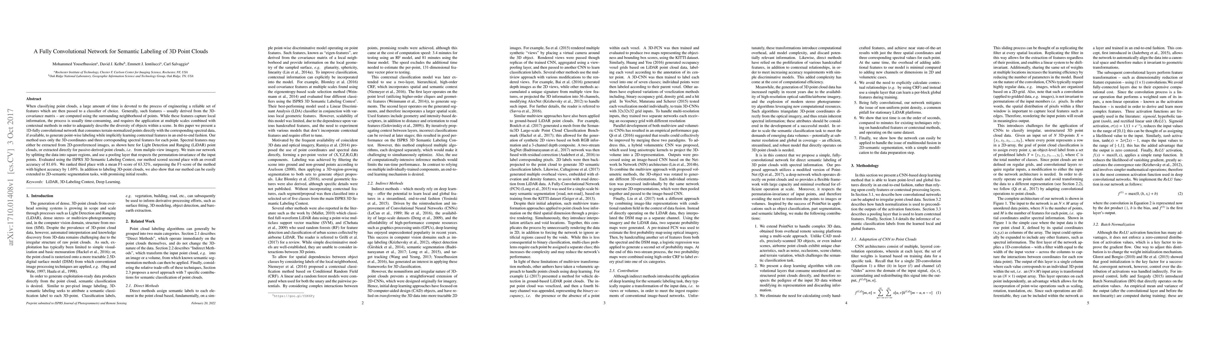
When classifying point clouds, a large amount of time is devoted to the process of engineering a reliable set of features which are then passed to a classifier of choice. Generally, such features - usually derived from the 3D-covariance matrix - are computed using the surrounding neighborhood of points. While these features capture local information, the process is usually time-consuming, and requires the application at multiple scales combined with contextual methods in order to adequately describe the diversity of objects within a scene. In this paper we present a 1D-fully convolutional network that consumes terrain-normalized points directly with the corresponding spectral data,if available, to generate point-wise labeling while implicitly learning contextual features in an end-to-end fashion. Our method uses only the 3D-coordinates and three corresponding spectral features for each point. Spectral features may either be extracted from 2D-georeferenced images, as shown here for Light Detection and Ranging (LiDAR) point clouds, or extracted directly for passive-derived point clouds,i.e. from muliple-view imagery. We train our network by splitting the data into square regions, and use a pooling layer that respects the permutation-invariance of the input points. Evaluated using the ISPRS 3D Semantic Labeling Contest, our method scored second place with an overall accuracy of 81.6%. We ranked third place with a mean F1-score of 63.32%, surpassing the F1-score of the method with highest accuracy by 1.69%. In addition to labeling 3D-point clouds, we also show that our method can be easily extended to 2D-semantic segmentation tasks, with promising initial results.

AI Key Findings

Get AI-generated insights about this paper's methodology, results, and significance.

Paper Details

PDF Preview

Download PDF

Key Terms

labeling (0.237)
clouds (0.227)
contextual (0.180)
features (0.177)
point (0.168)
score (0.165)
extracted (0.150)
points (0.150)
semantic (0.149)
place (0.147)
usually (0.145)
spectral (0.143)
directly (0.128)
end (0.123)
derived (0.118)
semantic segmentation (0.115)
lidar (0.114)
permutation (0.114)
method (0.114)
accuracy (0.113)
Title Authors Year Actions
Semantic Segmentation of Urban Airborne LiDAR Point Clouds Based on Fusion Attention Mechanism and Multi-Scale Features
Jingxue Wang, Huan Li, Zhenghui Xu, Xiao Xie
2023
View Paper
IPCONV: Convolution with Multiple Different Kernels for Point Cloud Semantic Segmentation
Ruixiang Zhang, Siyang Chen, Xuying Wang, Yunsheng Zhang
2023
View Paper
Deep learning-based 3D point cloud classification: A systematic survey and outlook
Huang Zhang, Changshuo Wang, Shengwei Tian, Baoli Lu, Liping Zhang, X. Ning, Xiao Bai
2023
View Paper
Data Preparation Impact on Semantic Segmentation of 3D Mobile LiDAR Point Clouds Using Deep Neural Networks
Reza Mahmoudi Kouhi, S. Daniel, P. Giguère
2023
View Paper
A co-learning method to utilize optical images and photogrammetric point clouds for building extraction
Yuxing Xie, Jiaojiao Tian, Xiaoxiang Zhu
2023
View Paper
A Multiscale Multi-Feature Deep Learning Model for Airborne Point-Cloud Semantic Segmentation
Peipei He, Zheng Ma, Meiqi Fei, Wenkai Liu, Guihai Guo, Mingwei Wang
2022
View Paper
A Prior Level Fusion Approach for the Semantic Segmentation of 3D Point Clouds Using Deep Learning
Z. Ballouch, R. Hajji, Florent Poux, A. Kharroubi, R. Billen
2022
View Paper
Beyond single receptive field: A receptive field fusion-and-stratification network for airborne laser scanning point cloud classification
Yongqiang Mao, Kaiqiang Chen, Wenhui Diao, Xian Sun, Xiaonan Lu, Kun Fu, M. Weinmann
2022
View Paper
Weakly supervised semantic segmentation of airborne laser scanning point clouds
Yaping Lin, G. Vosselman, M. Yang
2022
View Paper
VD-LAB: A view-decoupled network with local-global aggregation bridge for airborne laser scanning point cloud classification
Jihao Li, M. Weinmann, Xian Sun, Wenhui Diao, Yingchao Feng, S. Hinz, Kun Fu
2022
View Paper
Three-Dimensional Urban Land Cover Classification by Prior-Level Fusion of LiDAR Point Cloud and Optical Imagery
Yanming Chen, Xiaoqiang Liu, Yijia Xiao, Qiqi Zhao, Sida Wan
2021
View Paper
A hierarchical deep neural network with iterative features for semantic labeling of airborne LiDAR point clouds
Yetao Yang, Rong Tang, Jinglei Wang, Mengjiao Xia
2021
View Paper
Automated near-field deformation detection from mobile laser scanning for the 2014 Mw 6.0 South Napa earthquake
Xinxiang Zhu, C. Glennie, B. Brooks
2021
View Paper
RETRACTED: A novel semi-supervised method for airborne LiDAR point cloud classification
Xiang Li, Congcong Wen, Qiming Cao, Yanlei Du, Yi Fang
2021
View Paper
Graph Attention Feature Fusion Network for ALS Point Cloud Classification
Jie Yang, Xinchang Zhang, Yun Huang
2021
View Paper
GraNet: Global relation-aware attentional network for semantic segmentation of ALS point clouds
Rong Huang, Yusheng Xu, Uwe Stilla
2021
View Paper
Point2color: 3D Point Cloud Colorization Using a Conditional Generative Network and Differentiable Rendering for Airborne LiDAR
T. Shinohara, H. Xiu, M. Matsuoka
2021
View Paper
An Efficient and General Framework for Aerial Point Cloud Classification in Urban Scenarios
E. Özdemir, F. Remondino, A. Golkar
2021
View Paper
Airborne LiDAR point cloud classification with global-local graph attention convolution neural network
Congcong Wen, Xiang Li, Xiaojing Yao, Ling Peng, T. Chi
2021
View Paper
An anchor-based graph method for detecting and classifying indoor objects from cluttered 3D point clouds
Fei Su, Haihong Zhu, Chen Taoyi, Lin Li, Fan Yang, Huixiang Peng, Lei Tang, Xinkai Zuo, Liang Yifan, Shen Ying
2021
View Paper
MLNet: Multi-level Classification Network
Doudou Xue, Ying-lei Cheng, Pei Wen, Liyin Zhang
2021
View Paper
LGENet: Local and Global Encoder Network for Semantic Segmentation of Airborne Laser Scanning Point Clouds
Yaping Lin, G. Vosselman, Yanpeng Cao, M. Yang
2020
View Paper
ALS Point Cloud Classification by Integrating an Improved Fully Convolutional Network into Transfer Learning with Multi-Scale and Multi-View Deep Features
Xiangda Lei, Hongtao Wang, Cheng Wang, Zongze Zhao, Jianqi Miao, Puguang Tian
2020
View Paper
Incorporating Handcrafted Features into Deep Learning for Point Cloud Classification
P. Hsu, Zong-Yi Zhuang
2020
View Paper
Semi-automated framework for generating cycling lane centerlines on roads with roadside barriers from noisy MLS data
Yang Ma, Yubing Zheng, S. Easa, Jianchuan Cheng
2020
View Paper
A geometry-attentional network for ALS point cloud classification
Wuzhao Li, Fudong Wang, Guisong Xia
2020
View Paper
An Object-Based Bidirectional Method for Integrated Building Extraction and Change Detection between Multimodal Point Clouds
C. Dai, Zhenchao Zhang, D. Lin
2020
View Paper
Deep point embedding for urban classification using ALS point clouds: A new perspective from local to global
Rong Huang, Yusheng Xu, D. Hong, Wei Yao, Pedram Ghamisi, Uwe Stilla
2020
View Paper
Airborne LiDAR Point Cloud Classification with Graph Attention Convolution Neural Network
Congcong Wen, Xiang Li, Xiaojing Yao, Ling Peng, T. Chi
2020
View Paper
Fisher Vector Encoding of Supervoxel-Based Features for Airborne LiDAR Data Classification
Perpetual Hope Akwensi, Z. Kang, Juntao Yang
2020
View Paper
Large wood (LW) 3D accumulation mapping and assessment using structure from Motion photogrammetry in the laboratory
G. Spreitzer, J. Tunnicliffe, H. Friedrich
2020
View Paper
AERIAL POINT CLOUD CLASSIFICATION WITH DEEP LEARNING AND MACHINE LEARNING ALGORITHMS
E. Özdemir, Fabio Remondino, A. Golkar
2019
View Paper
Classification of ALS Point Clouds Using End-to-End Deep Learning
L. Winiwarter, G. Mandlburger, S. Schmohl, N. Pfeifer
2019
View Paper
An improved deep convolutional neural network with multi-scale information for bearing fault diagnosis
Wenyi Huang, Junsheng Cheng, Yu Yang, Gaoyuan Guo
2019
View Paper
Directionally Constrained Fully Convolutional Neural Network For Airborne Lidar Point Cloud Classification
Congcong Wen, Lina Yang, Ling Peng, Xiang Li, T. Chi
2019
View Paper
A Novel Octree-Based 3-D Fully Convolutional Neural Network for Point Cloud Classification in Road Environment
Binbin Xiang, Jingmin Tu, Jian Yao, Li Li
2019
View Paper
CLASSIFICATION OF AERIAL POINT CLOUDS WITH DEEP LEARNING
E. Özdemir, Fabio Remondino
2019
View Paper
SUBMANIFOLD SPARSE CONVOLUTIONAL NETWORKS FOR SEMANTIC SEGMENTATION OF LARGE-SCALE ALS POINT CLOUDS
S. Schmohl, U. Sörgel
2019
View Paper
A graph convolutional neural network for classification of building patterns using spatial vector data
Xiongfeng Yan, T. Ai, Min Yang, Hongmei Yin
2019
View Paper
Addressing Overfitting on Pointcloud Classification using Atrous XCRF
Hasan Asy’ari Arief, U. Indahl, G. Strand, H. Tveite
2019
View Paper
Object Classification using Deep Learning on Extremely Low-Resolution Time-of-Flight Data
Ana Daysi Ruvalcaba-Cardenas, T. Scoleri, Geoffrey Day
2018
View Paper
Classifying 3D objects in LiDAR point clouds with a back-propagation neural network
Wei Song, Shuanghui Zou, Yifei Tian, S. Fong, Kyungeun Cho
2018
View Paper
Segmentation and Multi-Scale Convolutional Neural Network-Based Classification of Airborne Laser Scanner Data
Zhishuang Yang, Bo Tan, Huikun Pei, Wanshou Jiang
2018
View Paper
Deep Learning-Based Fully Automated Pavement Crack Detection on 3D Asphalt Surfaces with an Improved CrackNet
Allen A. Zhang, Kelvin C. P. Wang, Yue Fei, Yang Liu, Siyu Tao, Cheng Chen, J. Li, Baoxian Li
2018
View Paper
Classification of 3 D Point Clouds using Deep Neural Networks
L. Winiwarter, G. Mandlburger
2019
View Paper
End-to-end learning and sensor fusion with deep convolutional networks for steering an off-road unmanned ground vehicle
Johann A. Dirdal
2018
View Paper

Comments (0)

This website uses cookies to ensure you get the best experience. Learn more