A Graph-Based Modeling Framework for Tracing Hydrological Pollutant Transport in Surface Waters
Publication
Metrics
AI Quick Summary
This paper introduces a graph-based modeling framework called ${\tt HydroGraphs}$ to trace pollutant transport in surface waters using open-source data. It aims to simplify complex hydrological systems for effective pollution prevention and mitigation by identifying pollutant sources and tracing impacts.
Paper Preview
Abstract
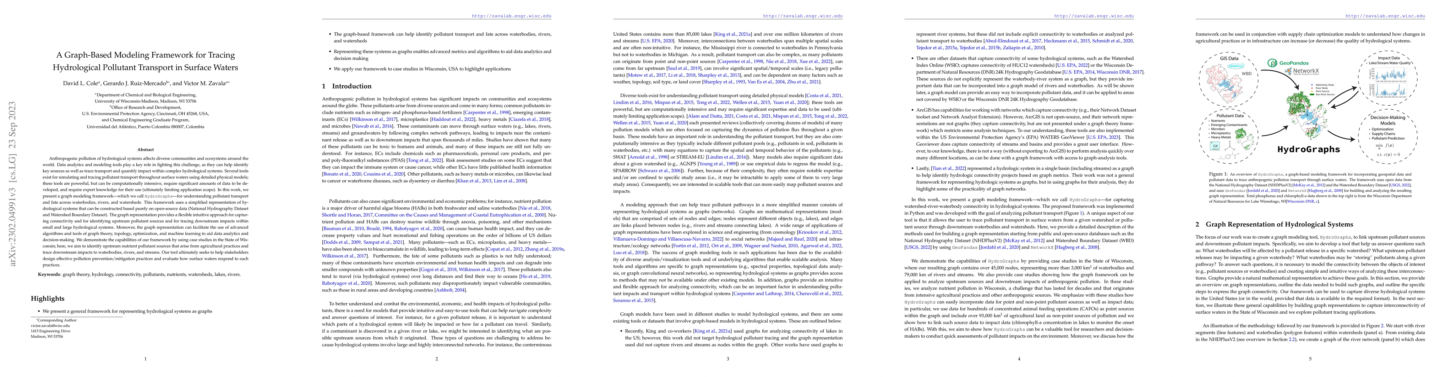
Anthropogenic pollution of hydrological systems affects diverse communities and ecosystems around the world. Data analytics and modeling tools play a key role in fighting this challenge, as they can help identify key sources as well as trace transport and quantify impact within complex hydrological systems. Several tools exist for simulating and tracing pollutant transport throughout surface waters using detailed physical models; these tools are powerful, but can be computationally intensive, require significant amounts of data to be developed, and require expert knowledge for their use (ultimately limiting application scope). In this work, we present a graph modeling framework -- which we call ${\tt HydroGraphs}$ -- for understanding pollutant transport and fate across waterbodies, rivers, and watersheds. This framework uses a simplified representation of hydrological systems that can be constructed based purely on open-source data (National Hydrography Dataset and Watershed Boundary Dataset). The graph representation provides an flexible intuitive approach for capturing connectivity and for identifying upstream pollutant sources and for tracing downstream impacts within small and large hydrological systems. Moreover, the graph representation can facilitate the use of advanced algorithms and tools of graph theory, topology, optimization, and machine learning to aid data analytics and decision-making. We demonstrate the capabilities of our framework by using case studies in the State of Wisconsin; here, we aim to identify upstream nutrient pollutant sources that arise from agricultural practices and trace downstream impacts to waterbodies, rivers, and streams. Our tool ultimately seeks to help stakeholders design effective pollution prevention/mitigation practices and evaluate how surface waters respond to such practices.
AI Key Findings
Get AI-generated insights about this paper's methodology, results, significance, and more — seven facets brought into focus.
Impact
Paper Details
Authors
PDF Preview
Key Terms
Citation Network
Current paper (gray), citations (green), references (blue)
Display is limited for performance on very large graphs.
Discussion 0