A Machine Learning Data Fusion Model for Soil Moisture Retrieval
Publication
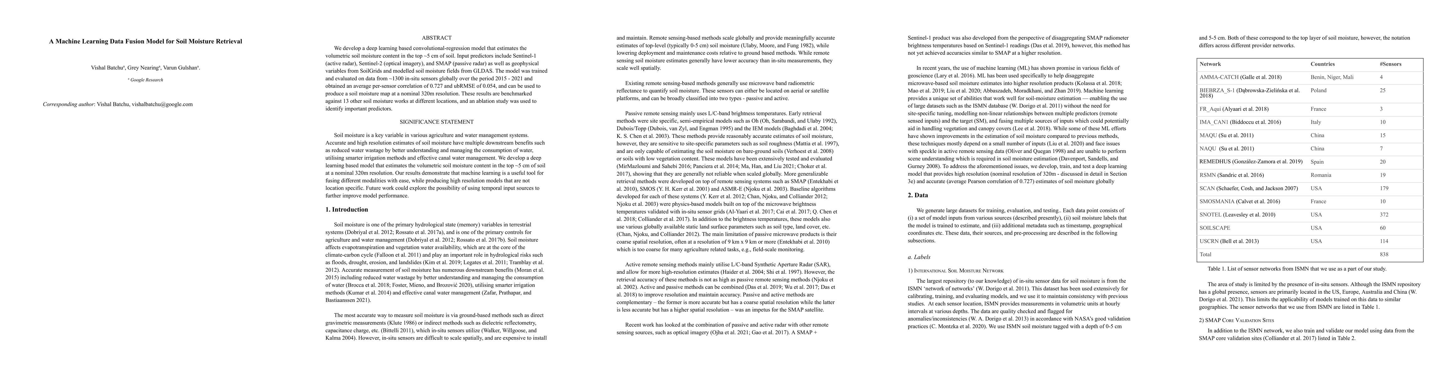
Metrics
AI Quick Summary
This research presents a convolutional-regression deep learning model for estimating soil moisture using multi-source data fusion, achieving a correlation of 0.727 and ubRMSE of 0.054, and providing soil moisture maps at 320m resolution. The model's effectiveness is benchmarked against 13 other studies.
Paper Preview
Abstract
We develop a deep learning based convolutional-regression model that estimates the volumetric soil moisture content in the top ~5 cm of soil. Input predictors include Sentinel-1 (active radar), Sentinel-2 (optical imagery), and SMAP (passive radar) as well as geophysical variables from SoilGrids and modelled soil moisture fields from GLDAS. The model was trained and evaluated on data from ~1300 in-situ sensors globally over the period 2015 - 2021 and obtained an average per-sensor correlation of 0.727 and ubRMSE of 0.054, and can be used to produce a soil moisture map at a nominal 320m resolution. These results are benchmarked against 13 other soil moisture works at different locations, and an ablation study was used to identify important predictors.
AI Key Findings
Get AI-generated insights about this paper's methodology, results, significance, and more — seven facets brought into focus.
Impact
Paper Details
Authors
PDF Preview
Key Terms
Citation Network
Current paper (gray), citations (green), references (blue)
Display is limited for performance on very large graphs.
Discussion 0