Summary

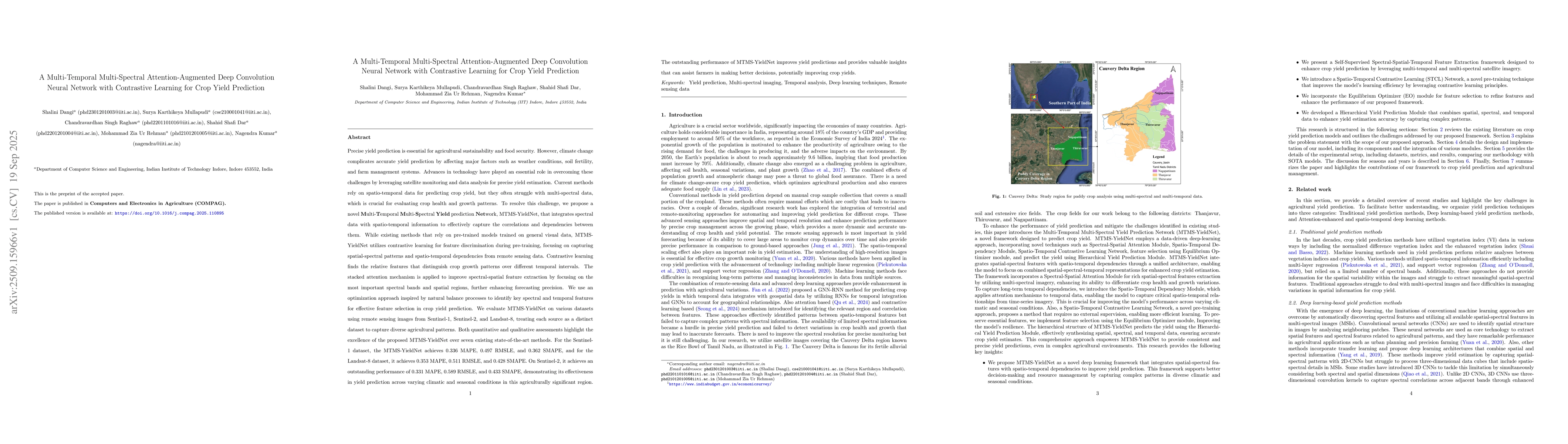
Precise yield prediction is essential for agricultural sustainability and food security. However, climate change complicates accurate yield prediction by affecting major factors such as weather conditions, soil fertility, and farm management systems. Advances in technology have played an essential role in overcoming these challenges by leveraging satellite monitoring and data analysis for precise yield estimation. Current methods rely on spatio-temporal data for predicting crop yield, but they often struggle with multi-spectral data, which is crucial for evaluating crop health and growth patterns. To resolve this challenge, we propose a novel Multi-Temporal Multi-Spectral Yield Prediction Network, MTMS-YieldNet, that integrates spectral data with spatio-temporal information to effectively capture the correlations and dependencies between them. While existing methods that rely on pre-trained models trained on general visual data, MTMS-YieldNet utilizes contrastive learning for feature discrimination during pre-training, focusing on capturing spatial-spectral patterns and spatio-temporal dependencies from remote sensing data. Both quantitative and qualitative assessments highlight the excellence of the proposed MTMS-YieldNet over seven existing state-of-the-art methods. MTMS-YieldNet achieves MAPE scores of 0.336 on Sentinel-1, 0.353 on Landsat-8, and an outstanding 0.331 on Sentinel-2, demonstrating effective yield prediction performance across diverse climatic and seasonal conditions. The outstanding performance of MTMS-YieldNet improves yield predictions and provides valuable insights that can assist farmers in making better decisions, potentially improving crop yields.

AI Key Findings

Generated Sep 30, 2025

Methodology

The study proposes the MTMS-YieldNet framework, which integrates multi-spectral data with spatio-temporal dependencies using a two-step training process. It employs contrastive learning for feature extraction and incorporates stacked attention mechanisms to refine spatial variations in soil properties.

Key Results

  • MTMS-YieldNet achieved significant improvements in crop yield prediction across Sentinel-1, Sentinel-2, and Landsat-8 datasets
  • The framework demonstrated better performance in specific seasons like Sep-Feb with lower MAPE, RMSLE, and SMAPE values
  • Synthetic image generation using diffusion models with TCD schedulers showed the most substantial performance gains

Significance

This research provides an advanced framework for accurate crop yield prediction using satellite imagery, which can support precision agriculture and food security planning by improving the reliability of yield forecasts.

Technical Contribution

The framework introduces a novel combination of spatio-temporal dependency modules and spectral-spatial attention mechanisms, along with advanced diffusion-based synthetic image generation techniques for improved feature extraction and model performance.

Novelty

This work stands out by integrating contrastive learning with stacked attention mechanisms and demonstrating the effectiveness of diffusion models with TCD schedulers for satellite imagery enhancement in crop yield prediction tasks.

Limitations

  • Performance metrics showed deviations at higher yield values across datasets
  • Atmospheric correction introduced artifacts that hindered model performance
  • The study focused on specific satellite datasets which may limit generalizability

Future Work

  • Exploring hybrid models with more sophisticated attention mechanisms
  • Investigating the impact of different satellite sensor configurations
  • Enhancing data preprocessing techniques to mitigate noise and artifacts
  • Expanding the framework to include more crop types and geographic regions

Paper Details

PDF Preview

Download PDF

Comments (0)

This website uses cookies to ensure you get the best experience. Learn more