Summary
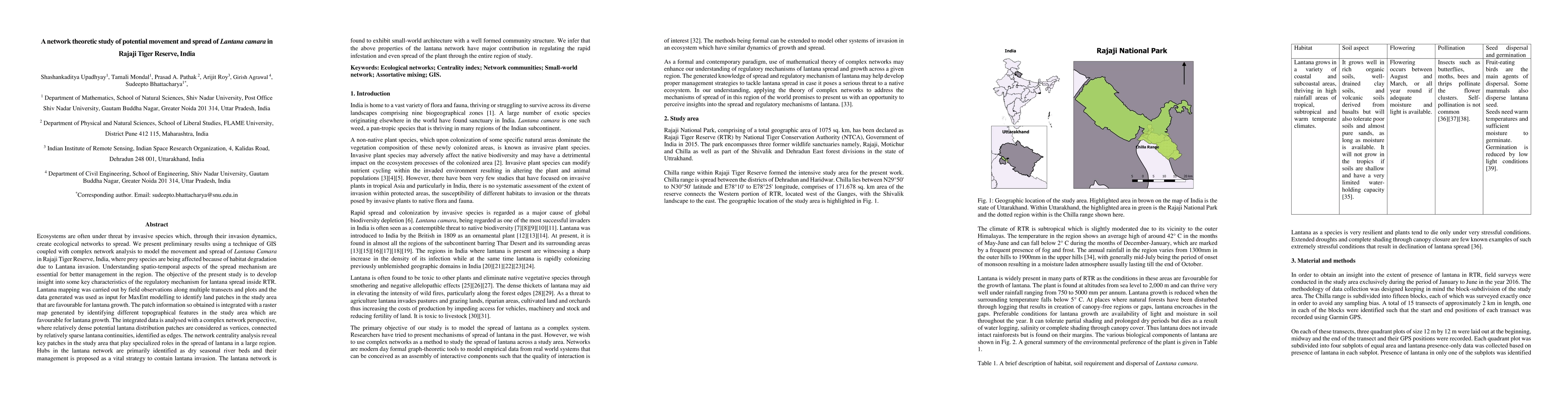
Ecosystems are often under threat by invasive species which, through their invasion dynamics, create ecological networks to spread. We present preliminary results using a technique of GIS coupled with complex network analysis to model the movement and spread of Lantana Camara in Rajaji Tiger Reserve, India, where prey species are being affected because of habitat degradation due to Lantana invasion. Understanding spatio-temporal aspects of the spread mechanism are essential for better management in the region. The objective of the present study is to develop insight into some key characteristics of the regulatory mechanism for lantana spread inside RTR. Lantana mapping was carried out by field observations along multiple transects and plots and the data generated was used as input for MaxEnt modelling to identify land patches in the study area that are favourable for lantana growth. The patch information so obtained is integrated with a raster map generated by identifying different topographical features in the study area which are favourable for lantana growth. The integrated data is analysed with a complex network perspective, where relatively dense potential lantana distribution patches are considered as vertices, connected by relatively sparse lantana continuities, identified as edges. The network centrality analysis reveal key patches in the study area that play specialized roles in the spread of lantana in a large region. Hubs in the lantana network are primarily identified as dry seasonal river beds and their management is proposed as a vital strategy to contain lantana invasion. The lantana network is found to exhibit small-world architecture with a well formed community structure. We infer that the above properties of the lantana network have major contribution in regulating the rapid infestation and even spread of the plant through the entire region of study.
AI Key Findings
Get AI-generated insights about this paper's methodology, results, and significance.
Paper Details
PDF Preview
Key Terms
Citation Network
Current paper (gray), citations (green), references (blue)
Display is limited for performance on very large graphs.
Similar Papers
Found 4 papersNetwork based control strategies for sustainable management of Lantana camara
R. K. Brojen Singh, Preet Mishra, Shyam Kumar
Optimal Control of Lantana camara: An Entropy-Based Sustainable Strategy
Preet Mishra, Shyam Kumar, R K Brojen Singh
Metschnikowia ratanii f.a. sp. nov., an ascomycetous yeast species isolated from flowers of Lantana camara in India.
Avchar, Rameshwar, Pontes, Ana, Lachance, Marc-André et al.
No citations found for this paper.
Comments (0)