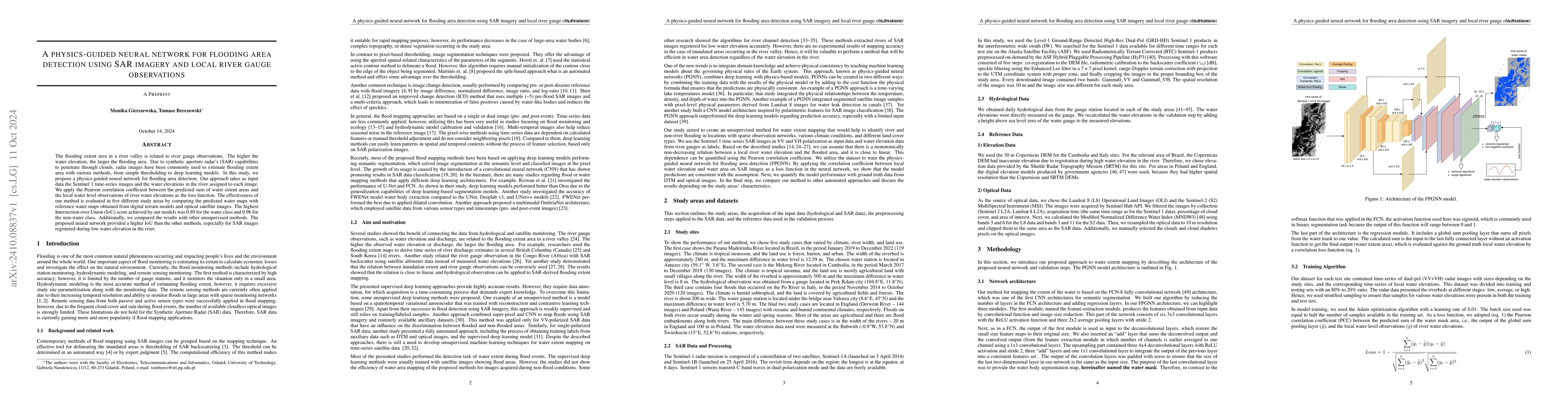
A physics-guided neural network for flooding area detection using SAR imagery and local river gauge observations
Publication
Metrics
AI Quick Summary
This study introduces a physics-guided neural network using SAR imagery and river gauge data to detect flooding areas, achieving an Intersection over Union (IoU) score of 0.89 for water areas and 0.96 for non-water areas, outperforming other unsupervised methods.
Paper Preview
Abstract
The flooding extent area in a river valley is related to river gauge observations. The higher the water elevation, the larger the flooding area. Due to synthetic aperture radar\textquoteright s (SAR) capabilities to penetrate through clouds, radar images have been commonly used to estimate flooding extent area with various methods, from simple thresholding to deep learning models. In this study, we propose a physics-guided neural network for flooding area detection. Our approach takes as input data the Sentinel 1 time-series images and the water elevations in the river assigned to each image. We apply the Pearson correlation coefficient between the predicted sum of water extent areas and the local water level observations of river water elevations as the loss function. The effectiveness of our method is evaluated in five different study areas by comparing the predicted water maps with reference water maps obtained from digital terrain models and optical satellite images. The highest Intersection over Union (IoU) score achieved by our models was 0.89 for the water class and 0.96 for the non-water class. Additionally, we compared the results with other unsupervised methods. The proposed neural network provided a higher IoU than the other methods, especially for SAR images registered during low water elevation in the river.
AI Key Findings
Get AI-generated insights about this paper's methodology, results, significance, and more — seven facets brought into focus.
Impact
Paper Details
Authors
PDF Preview
Citation Network
Current paper (gray), citations (green), references (blue)
Display is limited for performance on very large graphs.
Discussion 0