A Radar-Based Hail Climatology of Australia

Source: ArXiv

AI Quick Summary

This study develops Australia's first nationwide radar-based hail climatology using an empirical correction technique and object-based hail analysis, revealing spatiotemporal distribution, frequency, and regional variations of hailstorms. The methodology addresses the heterogeneous radar network and provides a more accurate hailfall understanding.

Share: Share on X LinkedIn

Summary

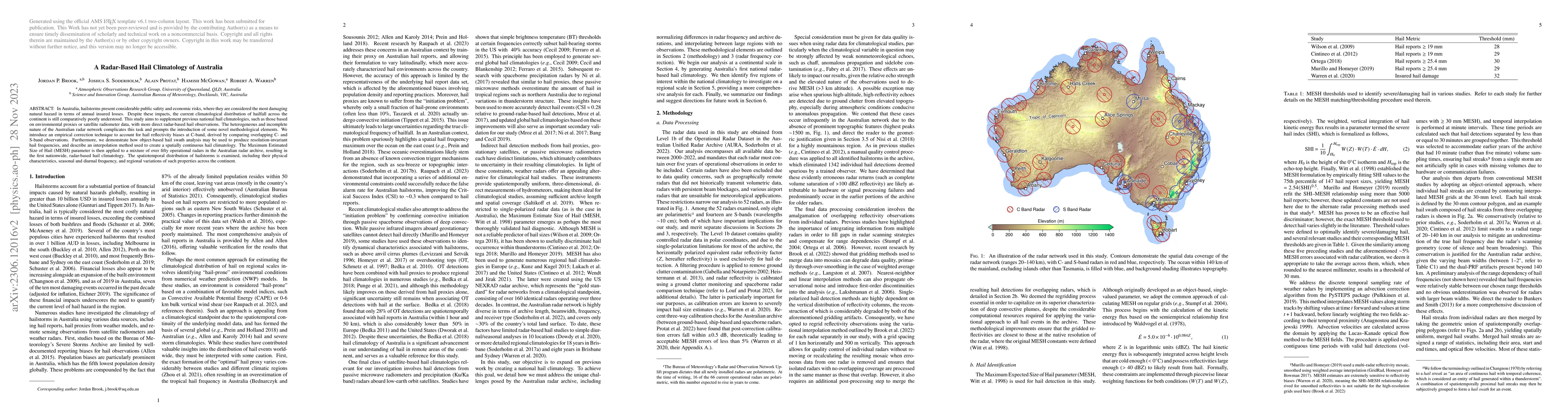
In Australia, hailstorms present considerable public safety and economic risks, where they are considered the most damaging natural hazard in terms of annual insured losses. Despite these impacts, the current climatological distribution of hailfall across the continent is still comparatively poorly understood. This study aims to supplement previous national hail climatologies, such as those based on environmental proxies or satellite radiometer data, with more direct radar-based hail observations. The heterogeneous and incomplete nature of the Australian radar network complicates this task and prompts the introduction of some novel methodological elements. We introduce an empirical correction technique to account for hail reflectivity biases at C-band, derived by comparing overlapping C- and S-band observations. Furthermore, we demonstrate how object-based hail swath analysis may be used to produce resolution-invariant hail frequencies, and describe an interpolation method used to create a spatially continuous hail climatology. The Maximum Estimated Size of Hail (MESH) parameter is then applied to a mixture of over fifty operational radars in the Australian radar archive, resulting in the first nationwide, radar-based hail climatology. The spatiotemporal distribution of hailstorms is examined, including their physical characteristics, seasonal and diurnal frequency, and regional variations of such properties across the continent.

AI Key Findings

Generated Sep 02, 2025

Methodology

This study introduces an object-based hail processing algorithm for resolution-invariant hail frequencies, proposes a hail reflectivity correction for C-band MESH calculations, and develops a novel variational interpolation method for a spatially continuous national hail climatology.

Key Results

  • A broad hail maximum was found on Australia's east coast, between Mackay and Sydney, with hailstorms occurring once every 3-5 years at individual locations.
  • Elevated hail frequencies also occur on the northwest coast and inland stretches of southwest Australia, but are less frequent than those on the east coast.
  • Hailstorms are most frequent on the easterly slopes of the Great Dividing Range around Brisbane and Sydney, with one hail event occurring roughly every 1-2 years.
  • Tropical hailstorms are shorter in terms of length and initiate later in the day with a strong land-sea contrast.
  • Subtropical hailstorms on the East Coast shift poleward throughout the summer, starting in Queensland in November and progressing toward Sydney by March.

Significance

This research provides a comprehensive radar-based hail climatology for Australia, contributing to understanding hailstorm risks, informing public safety measures, and supporting economic planning.

Technical Contribution

The study introduces an object-based hail processing algorithm, a C-band hail reflectivity correction, and a novel variational interpolation method for producing a spatially continuous national hail climatology.

Novelty

This research stands out by addressing the unique challenges posed by the Australian radar archive, introducing novel methodological elements, and providing a nationwide, radar-based hail climatology for Australia.

Limitations

  • The study is limited by the heterogeneous and incomplete nature of the Australian radar network.
  • Methodological differences in frequency estimation between this study and previous hail climatologies make direct comparisons challenging.
  • The accuracy of MESH for hail identification in different climatic regions, such as the tropics and southern Australia, remains to be validated.

Future Work

  • Investigate the use of secondary data sources, like weather model proxies or satellite-based products, to constrain hail frequency estimates in areas with poor radar coverage.
  • Examine the accuracy of MESH for hail identification in various climatic regions using hail reports and comparisons with satellite-based remote sensing products.
  • Explore the effects of storm-driven hail advection, melting, and size sorting on radar-based climatological assessments.

Paper Details

PDF Preview

Download PDF

Key Terms

radar (0.350)
band (0.171)
prompts (0.152)
national (0.147)
overlapping (0.143)
observations (0.142)
method used (0.139)
mesh (0.138)

Citation Network

Current paper (gray), citations (green), references (blue)

Display is limited for performance on very large graphs.

Current Paper
Citations
References
Click to view
Title Authors Year Actions

Comments (0)

This website uses cookies to ensure you get the best experience. Learn more