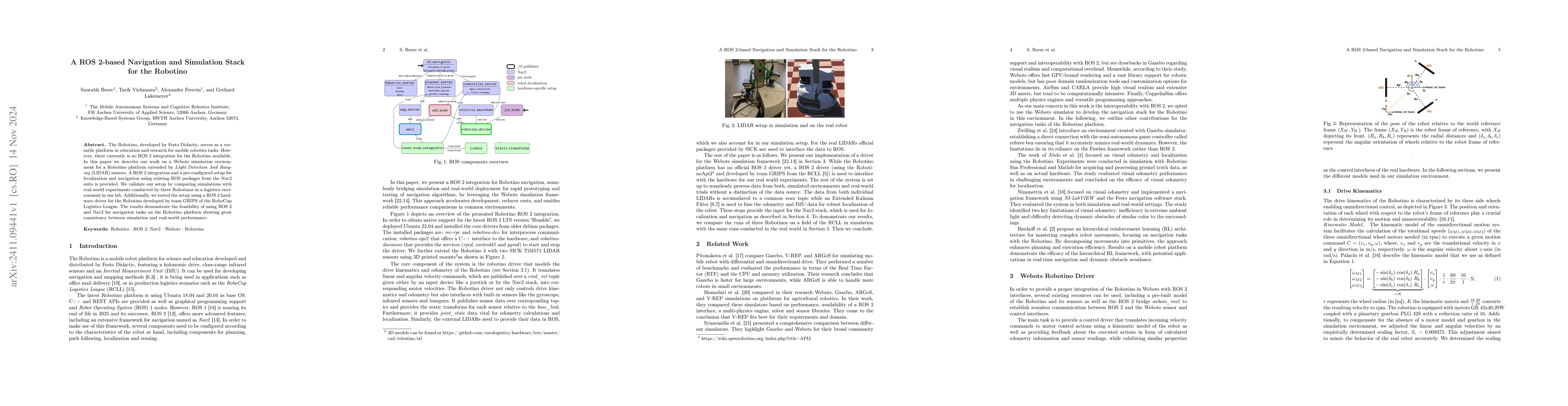
A ROS~2-based Navigation and Simulation Stack for the Robotino

Source: ArXiv

AI Quick Summary

This paper presents a ROS2-based navigation and simulation stack for the Robotino, integrating it with Webots and LIDAR sensors, and validating the setup through lab experiments and a comparison of simulated and real-world performance, demonstrating consistent results.

Share: Share on X LinkedIn

Summary

The Robotino, developed by Festo Didactic, serves as a versatile platform in education and research for mobile robotics tasks. However, there currently is no ROS2 integration for the Robotino available. In this paper, we describe our work on a Webots simulation environment for a Robotino platform extended by LIDAR sensors. A ROS2 integration and a pre-configured setup for localization and navigation using existing ROS packages from the Nav2 suite are provided. We validate our setup by comparing simulations with real-world experiments conducted by three Robotinos in a logistics environment in our lab. Additionally, we tested the setup using a ROS 2 hardware driver for the Robotino developed by team GRIPS of the RoboCup Logistics League. The results demonstrate the feasibility of using ROS2 and Nav2 for navigation tasks on the Robotino platform showing great consistency between simulation and real-world performance.

AI Key Findings

Generated Sep 02, 2025

Methodology

The research presents a ROS2-based navigation and simulation stack for the Robotino platform, utilizing a Webots simulation environment with LIDAR sensors and existing ROS packages from the Nav2 suite. The setup is validated through comparisons between simulations and real-world experiments with three Robotinos in a logistics environment.

Key Results

  • The setup demonstrates the feasibility of using ROS2 and Nav2 for navigation tasks on the Robotino platform, showing great consistency between simulation and real-world performance.
  • The study compares various simulation environments (Gazebo, AirSim, CARLA, CoppeliaSim) and selects Webots for its interoperability with ROS2 and fast GPU-bound rendering.
  • The proposed control driver successfully translates incoming velocity commands to motor control actions using a kinematic model of the robot.
  • The odometry in simulations exhibits notable inaccuracies due to wheel slippage and time discretization issues, prompting the implementation of an alternative GPS sensor-based odometry method.
  • The MPPI controller, chosen for its flexibility and predictive trajectory optimization, outperforms the DWB controller in navigating dynamic environments with frequent obstacles.

Significance

This research is significant as it provides a ROS2-based navigation and simulation stack for the Robotino platform, enabling consistent performance between simulation and real-world environments. This contributes to the advancement of mobile robotics education and research by offering a reliable, customizable, and efficient solution.

Technical Contribution

The main technical contribution is a ROS2-based navigation and simulation stack for the Robotino platform, integrating a Webots simulation environment with LIDAR sensors and ROS2 packages from the Nav2 suite, along with a custom control driver and odometry methods.

Novelty

This work is novel in its comprehensive approach to ROS2 integration for the Robotino platform, utilizing Webots for its advantages in interoperability with ROS2 and fast rendering, and implementing a custom control driver and odometry methods to address specific challenges in simulation and real-world performance.

Limitations

  • The study observed unexpected wheel slippage in simulation trials that does not occur in real trials.
  • The performance of recovery behaviors might need tweaking for domain-specific needs.
  • Turning behavior in both simulation and real-world trials could be improved, especially for real-world trials.

Future Work

  • Develop custom recovery behaviors that consider costmap data for collision-free driving.
  • Explore the use of the robots' infrared sensors for collision monitoring and leverage bumper sensors to reduce collision impact and aid in recovery.
  • Investigate Multi-Agent Path Finding (MAPF) for planning optimal collision-free paths for groups of robots.

Paper Details

PDF Preview

Download PDF

Citation Network

Current paper (gray), citations (green), references (blue)

Display is limited for performance on very large graphs.

Current Paper
Citations
References
Click to view

No citations found for this paper.

Comments (0)

This website uses cookies to ensure you get the best experience. Learn more