A SLAM Map Restoration Algorithm Based on Submaps and an Undirected Connected Graph
Publication
Metrics
AI Quick Summary
This paper presents a SLAM map restoration algorithm that reconstructs a complete global map for UAV datasets after tracking loss by merging submaps through an undirected connected graph. The method uses submaps and common map points determined via the bag-of-words method, showing improved map integrity compared to mainstream SLAM methods in UAV experiments.
Paper Preview
Abstract
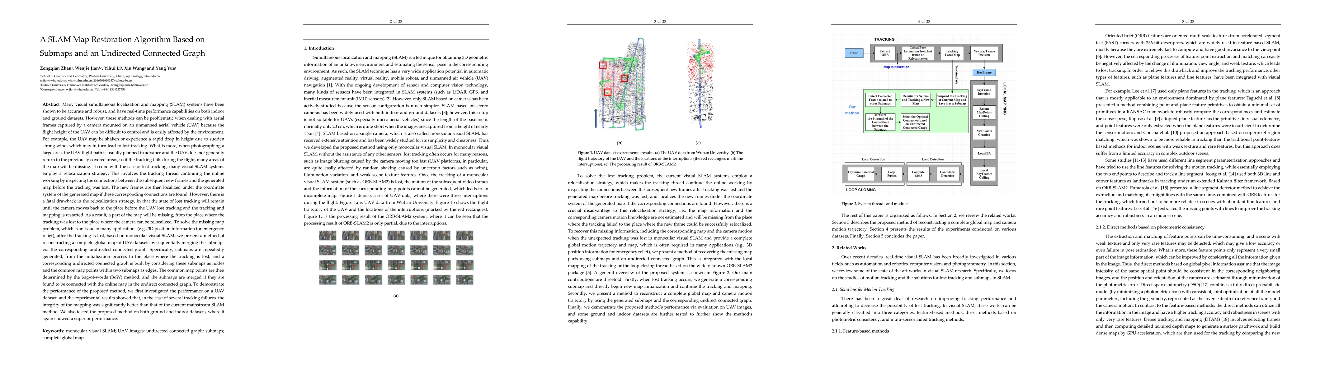
Many visual simultaneous localization and mapping (SLAM) systems have been shown to be accurate and robust, and have real-time performance capabilities on both indoor and ground datasets. However, these methods can be problematic when dealing with aerial frames captured by a camera mounted on an unmanned aerial vehicle (UAV) because the flight height of the UAV can be difficult to control and is easily affected by the environment.To cope with the case of lost tracking, many visual SLAM systems employ a relocalization strategy. This involves the tracking thread continuing the online working by inspecting the connections between the subsequent new frames and the generated map before the tracking was lost. To solve the missing map problem, which is an issue in many applications , after the tracking is lost, based on monocular visual SLAM, we present a method of reconstructing a complete global map of UAV datasets by sequentially merging the submaps via the corresponding undirected connected graph. Specifically, submaps are repeatedly generated, from the initialization process to the place where the tracking is lost, and a corresponding undirected connected graph is built by considering these submaps as nodes and the common map points within two submaps as edges. The common map points are then determined by the bag-of-words (BoW) method, and the submaps are merged if they are found to be connected with the online map in the undirect connected graph. To demonstrate the performance of the proposed method, we first investigated the performance on a UAV dataset, and the experimental results showed that, in the case of several tracking failures, the integrity of the mapping was significantly better than that of the current mainstream SLAM method.
AI Key Findings
Get AI-generated insights about this paper's methodology, results, significance, and more — seven facets brought into focus.
Impact
Paper Details
Authors
PDF Preview
Key Terms
Citation Network
Current paper (gray), citations (green), references (blue)
Display is limited for performance on very large graphs.
Discussion 0