A Spatial Agent-Based Model for Preemptive Evacuation Decisions During Typhoon

Source: ArXiv

AI Quick Summary

This paper presents an agent-based model to simulate preemptive evacuation decisions during typhoons in the Philippines, where civilians' evacuation choices are based on perceived risk influenced by decision maker characteristics, capacity factors, and hazard factors. The model uses census and geospatial data to simulate evacuation scenarios, demonstrating the significance of these factors through sensitivity analysis.

Share: Share on X LinkedIn

Summary

Natural disasters continue to cause tremendous damage to human lives and properties. The Philippines, due to its geographic location, is considered a natural disaster-prone country experiencing an average of 20 tropical cyclones annually. Understanding what factors significantly affect decision making during crucial evacuation stages could help in making decisions on how to prepare for disasters, how to act appropriately and strategically respond during and after a calamity. In this work, an agent-based model for preemptive 
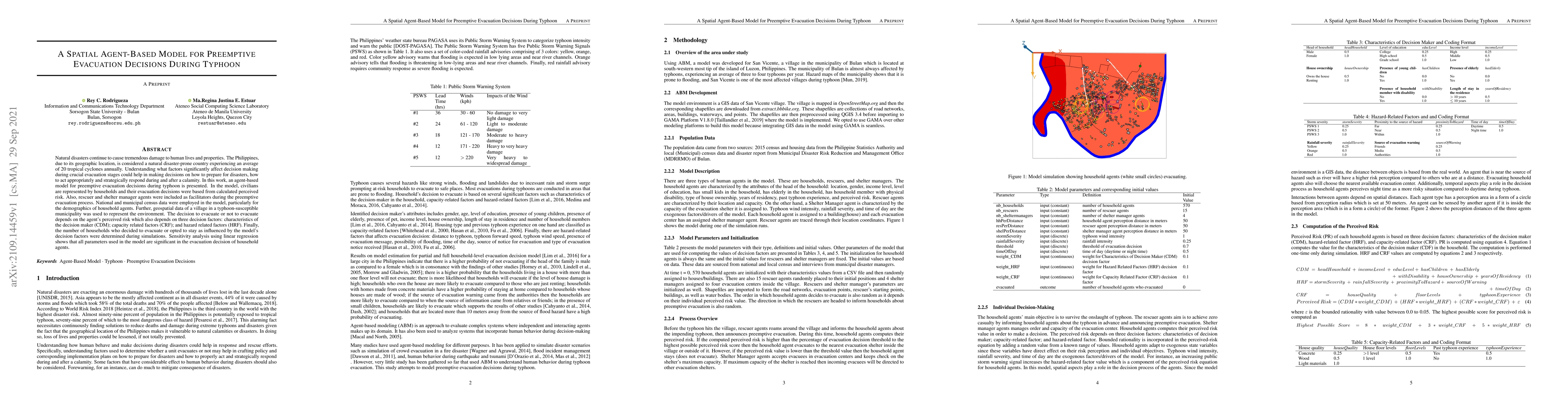
evacuation decisions during typhoon is presented. In the model, civilians are represented by households and their evacuation decisions were based from calculated perceived risk. Also, rescuer and shelter manager agents were included as facilitators during the preemptive evacuation process. National and municipal census data were employed in the model, particularly for the demographics of household agents. Further, geospatial data of a village in a typhoon-susceptible municipality was used to represent the environment. The decision to evacuate or not to evacuate depends on the agent's perceived risk which also depends on three decision factors: characteristics of the decision maker (CDM); capacity related factors (CRF); and hazard related factors (HRF). Finally, the number of households who decided to evacuate or opted to stay as influenced by the model`s decision factors were determined during simulations. Sensitivity analysis using linear regression shows that all parameters used in the model are significant in the evacuation decision of household agents.

AI Key Findings

Generated Sep 02, 2025

Methodology

This research employs a spatial agent-based model to simulate preemptive evacuation decisions during typhoons. The model incorporates household agents whose decisions are based on perceived risk, influenced by characteristics of decision-makers, capacity-related factors, and hazard-related factors. Exogenous factors such as typhoon wind intensity, rainfall severity, and time of day affect agents' risk perception. Spatial and temporal aspects are integrated into the decision-making process, with agents sensing others within a 50-meter perception area.

Key Results

  • All model parameters (weight_CDM, weight_HRF, weight_CRF, storm severity, rainfall severity, time of day, and threshold) significantly influence household agents' evacuation decisions.
  • The total evacuation decision is more sensitive to the threshold and weights assigned to capacity-related factors, such as house type, floor levels, and past typhoon experience.
  • Simulation results closely resemble real-world preemptive evacuation data, with one simulation (at 90% threshold) reflecting a typhoon event in San Vicente village in 2019 where 66 households preemptively evacuated.
  • Increasing weights for capacity-related factors consistently increases the number of households deciding to evacuate, while the effect of increasing weights for characteristics of decision-makers and hazard-related factors is not evident.
  • The model can be segmented into three parts based on the threshold of evacuation decision (70%, 80%, and 90%), with the 90% threshold scenario showing the closest alignment with real-world data.

Significance

This research provides insights for disaster managers and health emergency officers on why households decide to preemptively evacuate or stay, contributing to a better understanding of how perceived risk and its decision factors affect human behavior during disasters like typhoons.

Technical Contribution

The paper presents a spatial agent-based model that effectively simulates preemptive evacuation decisions during typhoons, integrating geospatial data and agent interactions based on perceived risk and decision factors.

Novelty

This work distinguishes itself by focusing on the heterogeneity of household agents and their perceived risk during typhoons, emphasizing the significant role of capacity-related factors in evacuation decisions, and validating the model against real-world preemptive evacuation data.

Limitations

  • The model focuses on a single typhoon-susceptible village, which may limit its generalizability to other geographical areas or disaster types.
  • The study does not account for factors such as communication infrastructure, transportation availability, or social networks that could influence evacuation decisions.

Future Work

  • Expand the model to include more diverse geographical locations and disaster types to enhance its generalizability.
  • Incorporate additional factors like communication infrastructure, transportation availability, and social networks to create a more comprehensive evacuation decision model.

Paper Details

PDF Preview

Download PDF

Key Terms

decision (0.313)
decision (0.297)
decisions (0.276)
factors (0.265)
decisions (0.260)
factors (0.260)
agents (0.254)
agents (0.249)

Citation Network

Current paper (gray), citations (green), references (blue)

Display is limited for performance on very large graphs.

Current Paper
Citations
References
Click to view
Title Authors Year Actions

Comments (0)

This website uses cookies to ensure you get the best experience. Learn more