Publication
Metrics
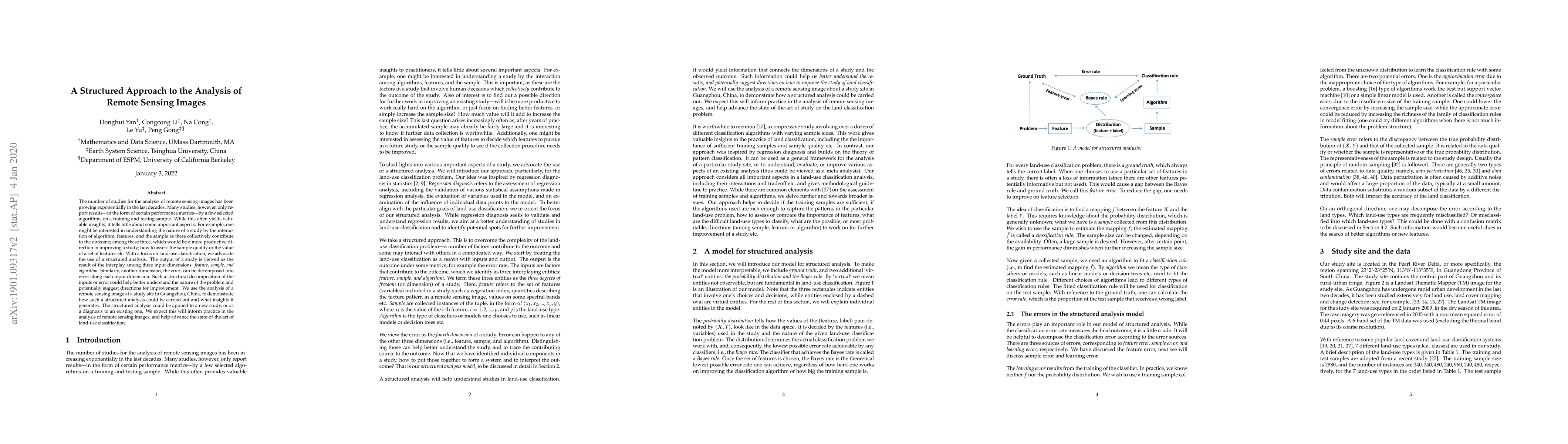
Paper Preview
Abstract
The number of studies for the analysis of remote sensing images has been growing exponentially in the last decades. Many studies, however, only report results---in the form of certain performance metrics---by a few selected algorithms on a training and testing sample. While this often yields valuable insights, it tells little about some important aspects. For example, one might be interested in understanding the nature of a study by the interaction of algorithm, features, and the sample as these collectively contribute to the outcome; among these three, which would be a more productive direction in improving a study; how to assess the sample quality or the value of a set of features etc. With a focus on land-use classification, we advocate the use of a structured analysis. The output of a study is viewed as the result of the interplay among three input dimensions: feature, sample, and algorithm. Similarly, another dimension, the error, can be decomposed into error along each input dimension. Such a structural decomposition of the inputs or error could help better understand the nature of the problem and potentially suggest directions for improvement. We use the analysis of a remote sensing image at a study site in Guangzhou, China, to demonstrate how such a structured analysis could be carried out and what insights it generates. The structured analysis could be applied to a new study, or as a diagnosis to an existing one. We expect this will inform practice in the analysis of remote sensing images, and help advance the state-of-the-art of land-use classification.
AI Key Findings
Get AI-generated insights about this paper's methodology, results, significance, and more — seven facets brought into focus.
Impact
Paper Details
Authors
PDF Preview
Key Terms
Citation Network
Current paper (gray), citations (green), references (blue)
Display is limited for performance on very large graphs.
Discussion 0