Summary
Residential location choices are traditionally modelled using factors related to accessibility and socioeconomic environments, neglecting the importance of local street-level conditions. Arguably, this neglect is due to data practices. Today, however, street-level images -- which are highly effective at encoding street-level conditions -- are widely available. Additionally, recent advances in discrete choice models incorporating computer vision capabilities offer opportunities to integrate street-level conditions into residential location choice analysis. This study leverages these developments to investigate the spatial distribution of utility derived from street-level conditions in residential location choices on a city-wide scale. In our case study of Rotterdam, the Netherlands, we find that the utility derived from street-level conditions varies significantly on a highly localised scale, with conditions rapidly changing even within neighbourhoods. Our results also reveal that the high real-estate prices in the city centre cannot be attributed to attractive street-level conditions. Furthermore, whereas the city centre is characterised by relatively unattractive residential street-level conditions, neighbourhoods in the southern part of the city -- often perceived as problematic -- exhibit surprisingly appealing street-level environments. The methodological contribution of this paper is that it advances the discrete choice models incorporating computer vision capabilities by introducing a semantic regularisation layer to the model. Thereby, it adds explainability and eliminates the need for a separate pipeline to extract information from images, streamlining the analysis. As such, this paper's findings and methodological advancements pave the way for further studies to explore integrating street-level conditions in urban planning.
AI Key Findings
Get AI-generated insights about this paper's methodology, results, and significance.
Paper Details
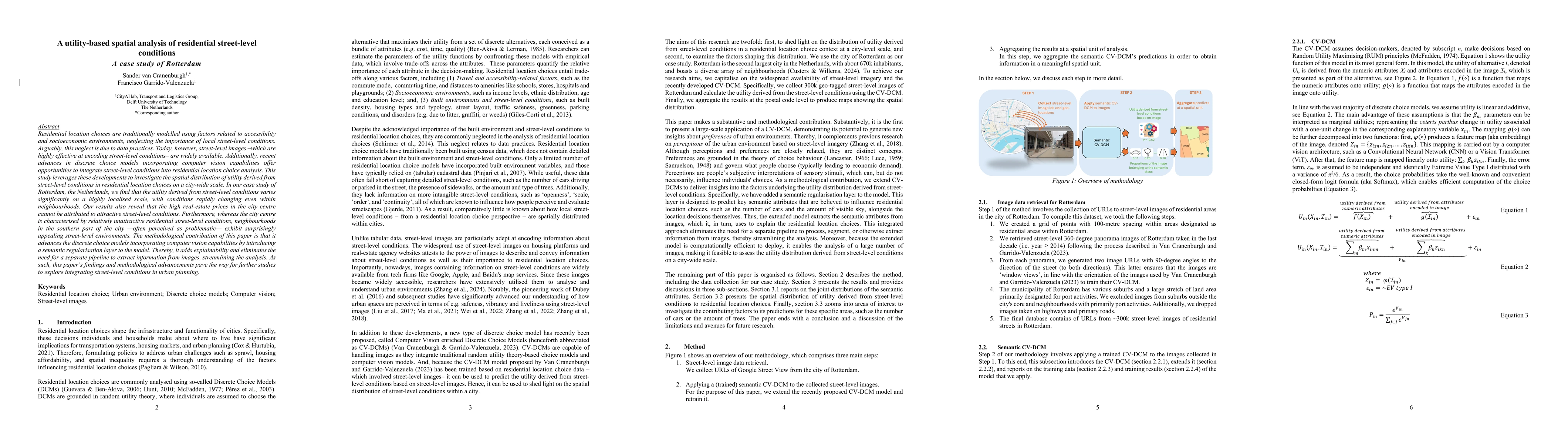
PDF Preview
Citation Network
Current paper (gray), citations (green), references (blue)
Display is limited for performance on very large graphs.
Similar Papers
Found 4 papersResidential greenspace and multiple chronic health conditions in China: a cross-sectional study.
Jan, Stephen, Wang, Siyuan, Si, Lei et al.
No citations found for this paper.
Comments (0)