Aboveground carbon biomass estimate with Physics-informed deep network
Publication
Metrics
AI Quick Summary
This paper develops a deep neural network to estimate aboveground carbon biomass in the Continental USA using radar, optical hyperspectral imagery, and SIF-based GPP. The model achieves a lower RMSE than traditional methods, demonstrating improved accuracy and applicability in measuring biomass losses from wildfires.
Paper Preview
Abstract
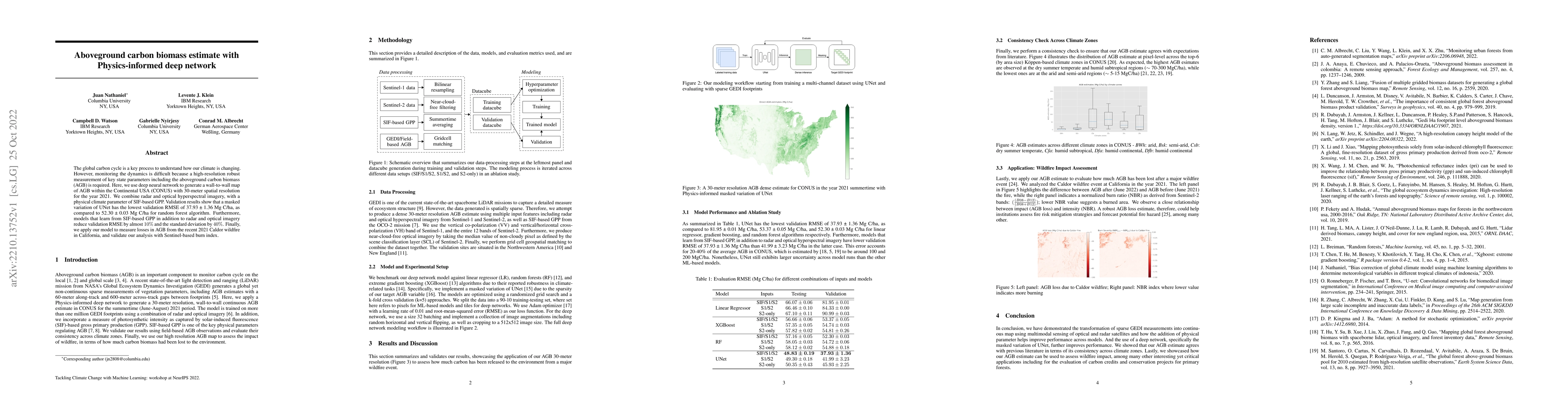
The global carbon cycle is a key process to understand how our climate is changing. However, monitoring the dynamics is difficult because a high-resolution robust measurement of key state parameters including the aboveground carbon biomass (AGB) is required. Here, we use deep neural network to generate a wall-to-wall map of AGB within the Continental USA (CONUS) with 30-meter spatial resolution for the year 2021. We combine radar and optical hyperspectral imagery, with a physical climate parameter of SIF-based GPP. Validation results show that a masked variation of UNet has the lowest validation RMSE of 37.93 $\pm$ 1.36 Mg C/ha, as compared to 52.30 $\pm$ 0.03 Mg C/ha for random forest algorithm. Furthermore, models that learn from SIF-based GPP in addition to radar and optical imagery reduce validation RMSE by almost 10% and the standard deviation by 40%. Finally, we apply our model to measure losses in AGB from the recent 2021 Caldor wildfire in California, and validate our analysis with Sentinel-based burn index.
AI Key Findings
Get AI-generated insights about this paper's methodology, results, significance, and more — seven facets brought into focus.
Impact
Paper Details
Authors
PDF Preview
Key Terms
Citation Network
Current paper (gray), citations (green), references (blue)
Display is limited for performance on very large graphs.
Discussion 0