The research proposes a risk-averse navigation framework for unknown 3D environments using active perception with 3D Gaussian Splatting (3DGS). It integrates safety-aware path planning with next-best-view (NBV) optimization on the SE(3) manifold, combining uncertainty reduction through active exploration and risk assessment based on Average Value-at-Risk (AV@R).
Active Next-Best-View Optimization for Risk-Averse Path Planning
Publication
Metrics
Quick Answers
What methodology did the authors use?
The research proposes a risk-averse navigation framework for unknown 3D environments using active perception with 3D Gaussian Splatting (3DGS). It integrates safety-aware path planning with next-best-view (NBV) optimization on the SE(3) manifold, combining uncertainty reduction through active exploration and risk assessment based on Average Value-at-Risk (AV@R). More in Methodology →
What are the key results?
The framework achieves safer trajectories with significantly higher AV@R scores compared to shortest-path baselines — Environment reconstruction quality improves with risk-aware masking strategies, showing better PSNR/SSIM and lower MAE/LPIPS metrics near robot trajectories More in Key Results →
Why is this work significant?
This work advances safe and efficient navigation in complex environments by directly quantifying risk from 3DGS representations. The integration of mapping, risk assessment, and viewpoint optimization enables both safety and reconstruction quality preservation, with potential applications in real-world autonomous systems. More in Significance →
What are the main limitations?
Performance depends heavily on the quality of the initial 3DGS map — Computational complexity may limit real-time deployment in highly dynamic environments More in Limitations →
Abstract
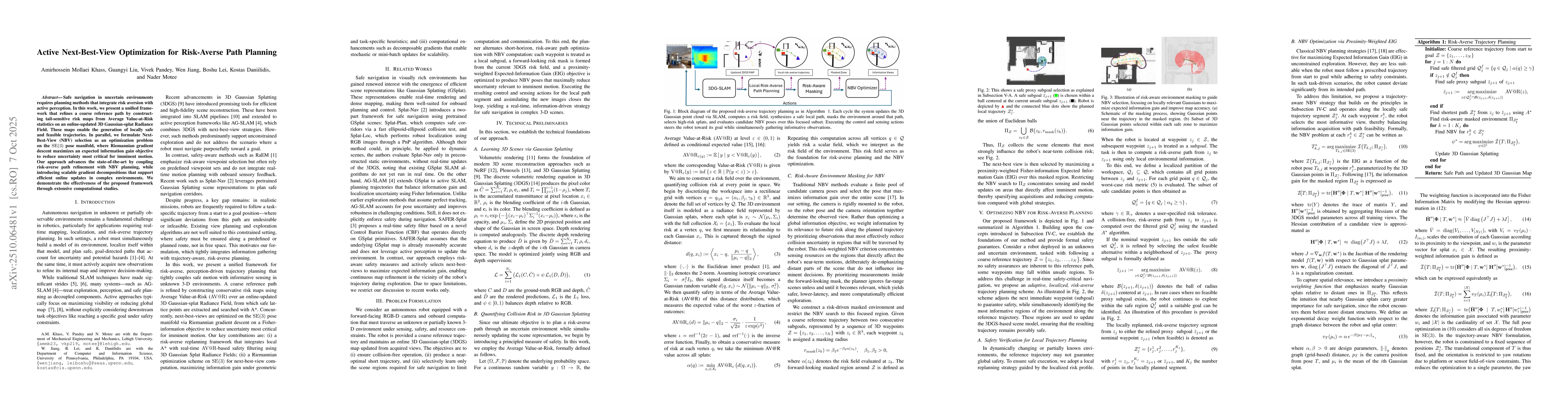
Safe navigation in uncertain environments requires planning methods that integrate risk aversion with active perception. In this work, we present a unified framework that refines a coarse reference path by constructing tail-sensitive risk maps from Average Value-at-Risk statistics on an online-updated 3D Gaussian-splat Radiance Field. These maps enable the generation of locally safe and feasible trajectories. In parallel, we formulate Next-Best-View (NBV) selection as an optimization problem on the SE(3) pose manifold, where Riemannian gradient descent maximizes an expected information gain objective to reduce uncertainty most critical for imminent motion. Our approach advances the state-of-the-art by coupling risk-averse path refinement with NBV planning, while introducing scalable gradient decompositions that support efficient online updates in complex environments. We demonstrate the effectiveness of the proposed framework through extensive computational studies.
Key Findings, in focus
Seven facets of this paper, analysed and brought into focus by AI.
This work advances safe and efficient navigation in complex environments by directly quantifying risk from 3DGS representations.
- The framework achieves safer trajectories with significantly higher AV@R scores compared to shortest-path baselines
- Environment reconstruction quality improves with risk-aware masking strategies, showing better PSNR/SSIM and lower MAE/LPIPS metrics near robot trajectories
- Optimized NBV methods show up to 64% increase in expected information gain compared to nominal views
This work advances safe and efficient navigation in complex environments by directly quantifying risk from 3DGS representations. The integration of mapping, risk assessment, and viewpoint optimization enables both safety and reconstruction quality preservation, with potential applications in real-world autonomous systems.
A novel SE(3)-optimized NBV strategy that actively reduces uncertainty while maintaining safety constraints, combined with risk-aware environment reconstruction through 3DGS mapping
First integration of risk assessment with active perception in 3DGS-based navigation, using AV@R metrics for safety quantification and SE(3)-manifold optimization for viewpoint selection
- Performance depends heavily on the quality of the initial 3DGS map
- Computational complexity may limit real-time deployment in highly dynamic environments
- Exploring adaptive risk thresholds for different mission priorities
- Integrating multi-sensor fusion with 3DGS for enhanced perception
- Developing lightweight implementations for edge computing
Discussion 0