AI Quick Summary
This paper proposes an adaptive sampling method using an Autonomous Underwater Vehicle (AUV) and satellite imagery to track algal bloom fronts in the Baltic Sea. The method employs a Gaussian process model to predict chlorophyll a concentration, guiding the AUV's sampling. Experimental validation in the Stockholm archipelago demonstrated the effectiveness of the approach.
Paper Preview
Abstract
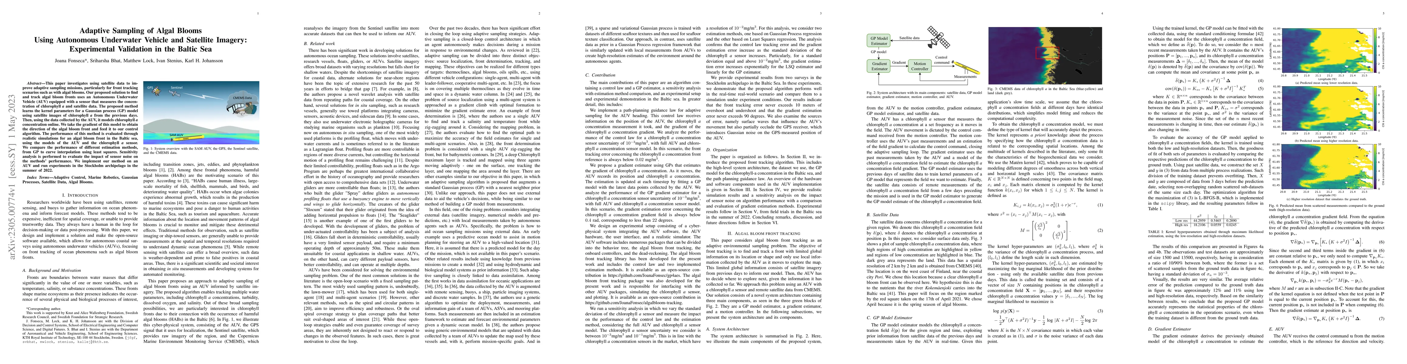
This paper investigates using satellite data to improve adaptive sampling missions, particularly for front tracking scenarios such as with algal blooms. Our proposed solution to find and track algal bloom fronts uses an Autonomous Underwater Vehicle (AUV) equipped with a sensor that measures the concentration of chlorophyll a and satellite data. The proposed method learns the kernel parameters for a Gaussian process model using satellite images of chlorophyll a from the previous days. Then, using the data collected by the AUV, it models chlorophyll a concentration online. We take the gradient of this model to obtain the direction of the algal bloom front and feed it to our control algorithm. The performance of this method is evaluated through realistic simulations for an algal bloom front in the Baltic sea, using the models of the AUV and the chlorophyll a sensor. We compare the performance of different estimation methods, from GP to curve interpolation using least squares. Sensitivity analysis is performed to evaluate the impact of sensor noise on the methods performance. We implement our method on an AUV and run experiments in the Stockholm archipelago in the summer of 2022.
AI Key Findings
Get AI-generated insights about this paper's methodology, results, and significance.
Paper Details
PDF Preview
Key Terms
Citation Network
Current paper (gray), citations (green), references (blue)
Display is limited for performance on very large graphs.
Similar Papers
Found 4 papersDetecting Endangered Marine Species in Autonomous Underwater Vehicle Imagery Using Point Annotations and Few-Shot Learning
Heather Doig, Oscar Pizarro, Jacquomo Monk et al.
Sea Trial Validation of the ROS-DESERT Middleware with Autonomous Underwater Vehicles
Davide Cosimo, Davide Costa, Riccardo Costanzi et al.
No citations found for this paper.
Comments (0)