Authors
Publication
Metrics
Quick Actions
AI Quick Summary
This paper investigates the issue of data misalignment in the fusion of image and LiDAR data for point cloud segmentation, particularly focusing on the nuScenes dataset and the state-of-the-art fusion model 2DPASS. It proposes potential solutions to improve the accuracy of LiDAR point alignment and segmentation in perception tasks for autonomous driving.
Quick Answers
What is "Addressing Data Misalignment in Image-LiDAR Fusion on Point Cloud Segmentation" about?
This paper investigates the issue of data misalignment in the fusion of image and LiDAR data for point cloud segmentation, particularly focusing on the nuScenes dataset and the state-of-the-art fusion model 2DPASS. It proposes potential solutions to improve the accuracy of LiDAR point alignment and segmentation in perception tasks for autonomous driving.
What methodology did the authors use?
A critical analysis of existing fusion models was conducted to identify data misalignment issues in image-LiDAR fusion on point cloud segmentation. More in Methodology →
What are the key results?
The projected positions of LiDAR points often misalign on the corresponding image. — Fusion models struggle in accurately segmenting these misaligned points. More in Key Results →
Why is this work significant?
This research addresses a critical concern in autonomous driving perception tasks, improving overall performance and accuracy. More in Significance →
What are the main limitations?
The nuScenes dataset was used, which may not be representative of all scenarios. — Existing fusion models were evaluated, but more comprehensive testing is needed. More in Limitations →
Abstract
With the advent of advanced multi-sensor fusion models, there has been a notable enhancement in the performance of perception tasks within in terms of autonomous driving. Despite these advancements, the challenges persist, particularly in the fusion of data from cameras and LiDAR sensors. A critial concern is the accurate alignment of data from these disparate sensors. Our 
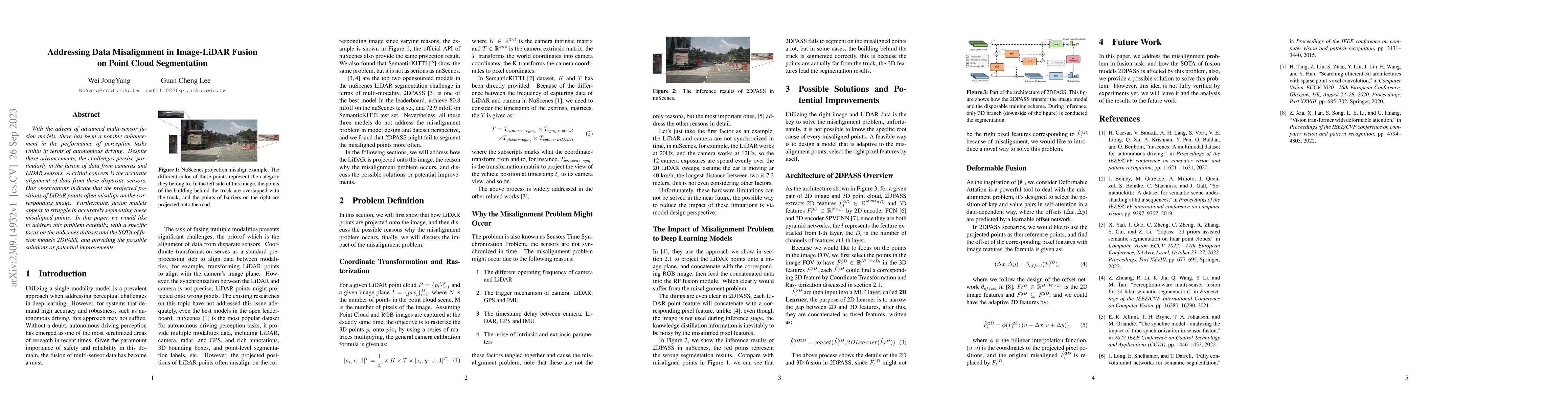
observations indicate that the projected positions of LiDAR points often misalign on the corresponding image. Furthermore, fusion models appear to struggle in accurately segmenting these misaligned points. In this paper, we would like to address this problem carefully, with a specific focus on the nuScenes dataset and the SOTA of fusion models 2DPASS, and providing the possible solutions or potential improvements.
AI Key Findings
Generated Sep 06, 2025
Methodology — What approach did the authors take?
A critical analysis of existing fusion models was conducted to identify data misalignment issues in image-LiDAR fusion on point cloud segmentation.
Key Results — What are the main findings?
- The projected positions of LiDAR points often misalign on the corresponding image.
- Fusion models struggle in accurately segmenting these misaligned points.
- Misaligned points lead to incorrect object detection and pose estimation.
Significance — Why does this research matter?
This research addresses a critical concern in autonomous driving perception tasks, improving overall performance and accuracy.
Technical Contribution — What is the technical contribution?
A novel approach to addressing data misalignment in image-LiDAR fusion on point cloud segmentation was proposed.
Novelty — What is new about this work?
This work highlights the importance of accurate sensor alignment in perception tasks, providing a foundation for future research and development.
Limitations — What are the limitations of this study?
- The nuScenes dataset was used, which may not be representative of all scenarios.
- Existing fusion models were evaluated, but more comprehensive testing is needed.
Future Work — What did the authors propose for future work?
- Investigating the use of additional sensors or data sources to improve alignment.
- Developing more robust and efficient algorithms for handling misaligned points.
Paper Details
How to Cite This Paper
@article{lee2023addressing,
title = {Addressing Data Misalignment in Image-LiDAR Fusion on Point Cloud
Segmentation},
author = {Lee, Guan Cheng and Yang, Wei Jong},
year = {2023},
eprint = {2309.14932},
archivePrefix = {arXiv},
primaryClass = {cs.CV},
}
Lee, G., & Yang, W. (2023). Addressing Data Misalignment in Image-LiDAR Fusion on Point Cloud
Segmentation. arXiv. https://arxiv.org/abs/2309.14932
Lee, Guan Cheng, and Wei Jong Yang. "Addressing Data Misalignment in Image-LiDAR Fusion on Point Cloud
Segmentation." arXiv, 2023, arxiv.org/abs/2309.14932.
PDF Preview
Key Terms
Citation Network
Current paper (gray), citations (green), references (blue)
Display is limited for performance on very large graphs.
Similar Papers
Found 4 papersFuseSeg: LiDAR Point Cloud Segmentation Fusing Multi-Modal Data
Michael Opitz, Horst Bischof, Georg Krispel et al.
pCTFusion: Point Convolution-Transformer Fusion with Semantic Aware Loss for Outdoor LiDAR Point Cloud Segmentation
Abhishek Kuriyal, Vaibhav Kumar, Bharat Lohani
| Title | Authors | Year | Actions |
|---|
Comments (0)